
Best Study Material for WBCS (West Bengal) Exam
WBCS (West Bengal) Exam > WBCS (West Bengal) Notes > WBCS Preparation: All Subjects > Rivers of West Bengal
Rivers of West Bengal | WBCS Preparation: All Subjects - WBCS (West Bengal) PDF Download
Drainage systems
River systems, or drainage systems, refer to the arrangements created by the streams, rivers, and lakes within a specific drainage basin. Their formation is influenced by the topography of the terrain, the prevalence of hard or soft rocks in a region, and the slope of the land.
River system as a Introduction
- As the Ganges enters West Bengal near Rajmahal, it flows southeastward, splitting into two near Dhulian in Murshidabad district. One branch becomes the Padma in Bangladesh, while the other becomes the Bhagirathi River and Hooghly River, flowing southward through West Bengal. The Bhagirathi is the primary river in West Bengal, passing important cities before releasing into the Bay of Bengal near Sagar Island.
- Various rivers such as the Mayurakshi, Ajay, Damodar, Kangsabati, and Rupnarayan, originating in the Western plateau, join the Bhagirathi on its right bank. The Damodar, controlled by the Damodar Valley Project, is known as the sorrow of Bengal. Distributaries of the Padma River, like Bhairab, Jalangi, and Mathabhanga, enter West Bengal and join the Bhagirathi on its left bank. Silting caused by these rivers poses challenges to the Kolkata Port and leads to flooding during heavy rains.
- The Sunderbans region is characterized by numerous estuaries and streams, mainly distributaries of major rivers like Hoogly, Matla, Gosaba, and others. The Teesta, Torsa, Jaldhaka, Kaljani, Raidak, Sankosh, and Mahananda rivers in the northern hilly region, originating in the Himalayas, flow southward through various districts before entering Bangladesh.
- Most rivers in the region are snow-fed, making them perennial and prone to flooding during the rainy season. The region is composed of sand, gravel, and pebbles deposited by these rivers.
RIVER BASINS of Rivers of West Bengal
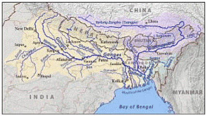
The state is divided into three drainage basins under the Ganga, Brahmaputra, and Subarnarekha systems, each further divided into sub-basins with individual catchments. The area-wise distribution of the main basins includes the Brahmaputra Basin, Ganga Basin (including Sundarban Area), and Subarnarekha Basin.
 |
Download the notes
Rivers of West Bengal
|
Download as PDF |
Download as PDF
Brahmaputra Basin Drainage System
The northern region of the state experiences high rainfall, particularly in the Sub-Himalayan regions of the northern districts. The Brahmaputra Basin covers an area of 11,860 sq.km, constituting approximately 14% of the state's geographical area. This basin includes numerous drainage channels that join main arteries such as the rivers Teesta, Torsa, Raidak, Mansai, and Jaldhaka. These rivers, originating in Bhutan/Sikkim, traverse the Terai region before reaching the plains of West Bengal and ultimately joining the Brahmaputra in Bangladesh. The Brahmaputra's tributaries include various rivers originating from the Himalayas in Bhutan/Sikkim.
 |
Take a Practice Test
Test yourself on topics from WBCS (West Bengal) exam
|
Practice Now |
Practice Now
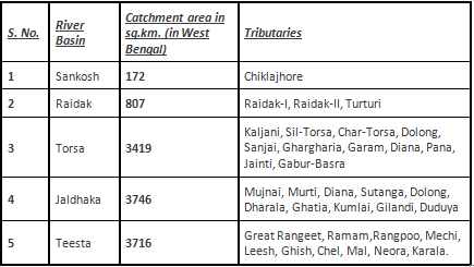
BRIEF DESCRIPTION OF RIVERS UNDER BRAHMAPUTRA BASIN
SANKOSH
Originating in Bhutan, the river Sankosh is the easternmost tributary of the Brahmaputra river basin. It acts as the boundary between the states of West Bengal and Assam. Eventually, it merges with Raidak-II and ultimately flows into the Brahmaputra in Bangladesh under the name Gangadhar.
RAIDAK
Beginning at an altitude of 6400 m in Mt. Akungphu in Bhutan, the Raidak River divides into two channels, Raidak-I and Raidak-II, near the Indo-Bangladesh border at Bhutanghat. Raidak-I combines with the Torsa and Kaljani streams, while Raidak-II is joined by the Sankosh, finally emptying into the Brahmaputra in Bangladesh as the Gangadhar.
TORSA
With its source in the Chumbi Valley of southern Tibet at 7065 m, the Torsa River traverses Tibet, Bhutan, West Bengal, and Bangladesh. After splitting into Sil-Torsa and Char-Torsa below the Hasimara bridge, the two channels reunite at Patla Khowa forest. Passing by Coochbehar town, the river is joined by the Kaljani and Raidak-I before flowing into the Brahmaputra near Nageswari in Rangpur, Bangladesh.
JALDHAKA
Originating at Bitang Lake in Sikkim at an altitude of 4400 m, the Jaldhaka River flows through Sikkim, Bhutan, West Bengal, and Bangladesh. After merging with various streams and tributaries, including the Dharala, it ultimately joins the Brahmaputra in Bangladesh.
TEESTA
The formidable North Bengal river, Teesta, begins in the glaciers of North Sikkim at an altitude of 6400 m. Formed by the union of Lachen and Lachung streams at Chungthung in Sikkim, it serves as the boundary between West Bengal and Sikkim up to Mechi. Tributaries like the Great Rangit and Rammam also act as natural boundaries. The river eventually flows into the Brahmaputra in the Rangpur district of Bangladesh.
GANGA BASIN
- The sacred rivers Bhagirathi and Alakananda, originating from Himalayan glaciers at 7000 m, merge at Devprayag to form the Ganga. After entering the plains at Rishikesh in Uttaranchal, it flows through Uttaranchal and Uttar Pradesh, receiving the Yamuna's flow at Allahabad. The Ganga then becomes the boundary between Uttar Pradesh and Bihar before entering Bihar and subsequently West Bengal. After joining the Kosi, the river continues eastward in Bihar and then enters West Bengal, where it divides into two arms below Farakka.
- The left arm, known as the Padma, flows eastward into Bangladesh, while the right arm, Bhagirathi, continues south through West Bengal. Beyond Nabadwip, the river is called Hooghly and ultimately meets the Bay of Bengal near Sagar Island. The Ganga Basin encompasses the central, southern, and southwestern parts of West Bengal, covering a total area of 74,732 sq.km within the state. The river's total length, measured along Bhagirathi and the Hooghly, is approximately 2575 km, with specific lengths in different states.
MAHANANDA
- The Mahananda River originates near Darjeeling town in the Darjeeling district, specifically from Ghoom. This river system is situated between latitude 25º15′ N to 26º15′ N and longitude 87º45′ E to 88º15′ E. It is bordered by the Himalayas to the north, ridges separating it from the Teesta river system to the east, the Ganga to the south, and the Kosi river system to the west.
- The river divides into two channels at Barsoi in Bihar, with one branch, named Fulahar, flowing through Bihar, and the other, named Mahananda, flowing through West Bengal. The Mahananda river, fed by tributaries such as Nagar, Kalindri, Tangon, and Punarbhaba, eventually joins the Ganga from the North-Western side at Godogarighat, just downstream of where the Ganga leaves the boundary of West Bengal.
ATRAI-PUNARBHABA
- Several rivers, including Sahu, Neem, Talma, Chaoai, and Panga, originate in the highlands of Jalpaiguri district and converge to form a stream called Karotowa. This stream enters Bangladesh as Atrai, which then bifurcates into Dheepa and Atrai channels. The Atrai channel re-enters West Bengal in South Dinajpur district, covering a length of 40 km, before entering Bangladesh again and eventually joining the Brahmaputra.
- The Dheepa channel takes a South-Western course, enters Gangarampur P.S. in South Dinajpur district, and becomes the Punarbhaba, flowing through Maldah district before entering Bangladesh. In Bangladesh, Punarbhaba meets the Mahananda river.
NAGAR-KULICK, GAMARI-CHIRAMATI, TANGON, KALINDRI
- Rivers such as Nagar, Kullick, Gamari, Chiramati, Tangon, and Kalindri flow through the districts of Malda and North Dinajpur. They often form boundaries between West Bengal and Bihar or West Bengal and Bangladesh. Nagar, originating in Bangladesh, flows along the West Bengal boundary, receiving a spill channel from Mahananda, and is joined by Kullick.
- Gamari and Chiramati, two smaller rivers, unite in North Dinajpur before joining Mahananda. Tangon, a Mahananda tributary, originates in Bangladesh, flows through North Dinajpur and Malda, and meets Mahananda on the boundary of Malda and Bangladesh.
PAGLA-BANSLOI-BRAHMANI
Rivers like Pagla, Bansloi, and Brahmani originate in the Rajmahal hills in Bihar. After flowing across Birbhum district, they become tributaries of the river Bhagirathi.
JALANGI-BHAIRAB
- Jalangi originates from the right bank of the Padma in Murshidabad district, downstream of Farakka. It remains dry except during the rainy season when it receives water from the Padma. Jalangi eventually flows into the Hooghly near Nabadwip.
- Bhairab starts from the Ganga in Lalbag P.S. of Murshidabad and, although mostly dry, receives water from the Padma during the rainy season.
ICHAMATI-CHURNI
- The Mathabhanga river begins at the mouth of the Jalangi of Padma and, while not significant in Nadia district, bifurcates into two streams - Churni and Ichamati.
- Churni and Ichamati flow through the districts in a south-east direction, with Ichamati receiving some supply from the Padma and relying on tidal flows for sustenance.
BHAGIRATHI-HOOGHLY
- The Ganga Brahmaputra Meghna river system is one of the world's largest, with the Ganga originating in the Himalayas and draining a vast area. Near Farakka, it divides into two channels, Bhagirathi-Hooghly and Padma. Bhagirathi-Hooghly flows through West Bengal and drains into the Bay of Bengal, while Padma crosses into Bangladesh, joining the Brahmaputra at Goalundo.
- Bhagirathi divides Murshidabad district and, after receiving right bank tributaries like Bagmari-Pagla, Mayurakshi, and Ajoy, becomes Hooghly. The river, formerly the main course of the Ganga, now serves as the main drainage artery for southern districts.
MAYURAKSHI-BABLA
- Mayurakshi originates in the Santhal Parganas highlands and is the primary river of Birbhum district. It gives rise to spill channels like Manikornika, Kana Mor, and Gambhira, which ultimately flow into Hijal Beel in Murshidabad.
- From Hijal Beel, the Babla river emerges, eventually draining into the Bhagirathi. The flood level in Hijal Beel is influenced by the Bhagirathi's level.
AJOY
Ajoy originates near Deoghar in Jharkhand and has principal tributaries like Hinghlow, Kunoor, Pathro, and Jayanti.
DAMODAR
Damodar originates in the Palamau hills and bifurcates at Beguahana, with one channel passing through Mundeswari and discharging into Rupnarayan, and the other, Amta channel, carrying high flood discharge and outfalling into the Hooghly.
DWARAKESWAR-SILABATI-RUPNARAYAN
- Dwarakeswar originates from the high lands of Purulia district.
- River Ganddheswari rising from Bankura district meets Dwarakeswar near Bankura town receiving water from streams like Arkasha, Berai, enters Hooghly district and meets Silabati to form Rupnarayan. Silabati also originates in Purulia district.
- It traverses through the district of Midnapore.
- The river receives water of Joypanda and meets with Dwarakeswar to form Rupnarayan. Rupnarayan is a combination of number of streams.
- The tidal reach below confluence of Dwarakeswar and Silabati is known as Rupnarayan.
- It outfalls into Hooghly after receiving mainflow of Damodar through Mundeswari and branch of Kangsabati.
- The river is tidal throughout its entire course.
KANGSABATI-KALIAGHAI-HALDI
- Kangsabati originates in Purulia and is joined by Kumari in Bankura. It later bifurcates into Old Cossye/Palaspai Khal, flowing into Rupnarayan, and New Cossye. Kaliaghai, originating from Jhargram, joins New Cossye to form Haldi, which ultimately falls into the Hooghly.
- The lower part of Haldi is prone to overbank spills and drainage issues during the monsoon.
RASULPUR
Rasulpur is formed by Bagda, Sarpai, and Madhakhali streams, serving as the main river in Contai Sub-Division of Midnapore district. It drains Dwarakeswar, Silabati, and a significant portion of Kangsabati rivers, causing flooding in Dubda and Contai areas before falling into the Hooghly.
TIDAL RIVERS OF SOUTHERN WEST BENGAL
- Apart from the rivers described earlier within the Ganga and the Brahmaputra river systems, there is a group of rivers in Southern part of the State which falls in the deltaic zone.
- These rivers mostly lie in the deltaic zone to the east of the Hooghly river popularly known as Sundarbans and form an intricate network with a number of criss-cross inter connecting channels, thus dividing the land spill channels of Ganga, then upland supply running dry, during winter months. But gradually their off-takes from Ganga have deteriorated and in some cases being cut-off from the river.
- Now these rivers drain off whatsoever fresh discharge comes from country sides, thus ultimately draining into Bay of Bengal through one or other of the principal estuaries in the area which are, starting from Hooghly river successively the Bartala of Muriganga or channel creek, Saptamukhi, Matla, Gosaba, Hariabhanga, Raimongal etc.
- The Tolly’s Nullah or the Adi Ganga, as it is sometimes called is a small but important tidal creek draining into the Hooghly from the left in the vicinity of the city of Kolkata.
The document Rivers of West Bengal | WBCS Preparation: All Subjects - WBCS (West Bengal) is a part of the WBCS (West Bengal) Course WBCS Preparation: All Subjects.
All you need of WBCS (West Bengal) at this link: WBCS (West Bengal)
|
77 videos|109 docs
|


FAQs on Rivers of West Bengal - WBCS Preparation: All Subjects - WBCS (West Bengal)
| 1. What are the major rivers in West Bengal? |  |
| 2. How do the rivers in West Bengal contribute to the state's economy? | |
Ans. The rivers in West Bengal play a significant role in the state's economy. They are used for irrigation, providing water for agriculture, generating hydroelectric power, and transportation of goods and people.
| 3. Are the rivers in West Bengal prone to flooding? | |
Ans. Yes, some rivers in West Bengal, such as the Ganges and Brahmaputra, are prone to flooding. The monsoon rains and the discharge of water from upstream areas can cause these rivers to overflow and result in widespread flooding in the state.
| 4. Are there any dams constructed on the rivers in West Bengal? | |
Ans. Yes, there are several dams constructed on the rivers in West Bengal. The major ones include the Farakka Barrage on the Ganges, the Teesta Barrage, and the Maithon Dam on the Damodar River. These dams serve various purposes like irrigation, flood control, and power generation.
| 5. How do the rivers in West Bengal contribute to the biodiversity of the state? | |
Ans. The rivers in West Bengal support a diverse range of aquatic life and provide habitats for various species of fish, turtles, dolphins, and migratory birds. The fertile floodplains created by these rivers also support agriculture and provide suitable conditions for the growth of various crops.
Related Exams
About this Document

4.89/5
Rating

Mar 31, 2025
Last updated
Document Description: Rivers of West Bengal for WBCS (West Bengal) 2025 is part of WBCS Preparation: All Subjects preparation.
The notes and questions for Rivers of West Bengal have been prepared according to the WBCS (West Bengal) exam syllabus. Information about Rivers of West Bengal covers topics
like and Rivers of West Bengal Example, for WBCS (West Bengal) 2025 Exam. Find important definitions, questions, notes, meanings, examples, exercises and tests below for Rivers of West Bengal.
Introduction of Rivers of West Bengal in English is available as part of our WBCS Preparation: All Subjects
for WBCS (West Bengal) & Rivers of West Bengal in Hindi for WBCS Preparation: All Subjects course.
Download more important topics related with notes, lectures and mock test series for WBCS (West Bengal)
Exam by signing up for free. WBCS (West Bengal): Rivers of West Bengal | WBCS Preparation: All Subjects - WBCS (West Bengal)
Description
Full syllabus notes, lecture & questions for Rivers of West Bengal | WBCS Preparation: All Subjects - WBCS (West Bengal) - WBCS (West Bengal) | Plus excerises question with solution to help you revise complete syllabus for WBCS Preparation: All Subjects | Best notes, free PDF download
Information about Rivers of West Bengal
In this doc you can find the meaning of Rivers of West Bengal defined & explained in the simplest way possible. Besides explaining types of
Rivers of West Bengal theory, EduRev gives you an ample number of questions to practice Rivers of West Bengal tests, examples and also practice WBCS (West Bengal)
tests

Related Searches
Exam
,Rivers of West Bengal | WBCS Preparation: All Subjects - WBCS (West Bengal)
,study material
,mock tests for examination
,shortcuts and tricks
,Previous Year Questions with Solutions
,past year papers
,ppt
,practice quizzes
,Rivers of West Bengal | WBCS Preparation: All Subjects - WBCS (West Bengal)
,Free
,Objective type Questions
,video lectures
,Viva Questions
,Extra Questions
,Semester Notes
,Sample Paper
,MCQs
,Summary
,Rivers of West Bengal | WBCS Preparation: All Subjects - WBCS (West Bengal)
,Important questions
;


Additional Information about Rivers of West Bengal for WBCS (West Bengal) Preparation
Rivers of West Bengal Free PDF Download
The Rivers of West Bengal is an invaluable resource that delves deep into the core of the WBCS (West Bengal) exam.
These study notes are curated by experts and cover all the essential topics and concepts, making your preparation more efficient and effective.
With the help of these notes, you can grasp complex subjects quickly, revise important points easily,
and reinforce your understanding of key concepts. The study notes are presented in a concise and easy-to-understand manner,
allowing you to optimize your learning process. Whether you're looking for best-recommended books, sample papers, study material,
or toppers' notes, this PDF has got you covered. Download the Rivers of West Bengal now and kickstart your journey towards success in the WBCS (West Bengal) exam.
Importance of Rivers of West Bengal
The importance of Rivers of West Bengal cannot be overstated, especially for WBCS (West Bengal) aspirants.
This document holds the key to success in the WBCS (West Bengal) exam.
It offers a detailed understanding of the concept, providing invaluable insights into the topic.
By knowing the concepts well in advance, students can plan their preparation effectively.
Utilize this indispensable guide for a well-rounded preparation and achieve your desired results.
Rivers of West Bengal Notes
Rivers of West Bengal Notes offer in-depth insights into the specific topic to help you master it with ease.
This comprehensive document covers all aspects related to Rivers of West Bengal.
It includes detailed information about the exam syllabus, recommended books, and study materials for a well-rounded preparation.
Practice papers and question papers enable you to assess your progress effectively.
Additionally, the paper analysis provides valuable tips for tackling the exam strategically.
Access to Toppers' notes gives you an edge in understanding complex concepts.
Whether you're a beginner or aiming for advanced proficiency, Rivers of West Bengal Notes on EduRev are your ultimate resource for success.
Rivers of West Bengal WBCS (West Bengal) Questions
The "Rivers of West Bengal WBCS (West Bengal) Questions" guide is a valuable resource for all aspiring students preparing for the
WBCS (West Bengal) exam. It focuses on providing a wide range of practice questions to help students gauge
their understanding of the exam topics. These questions cover the entire syllabus, ensuring comprehensive preparation.
The guide includes previous years' question papers for students to familiarize themselves with the exam's format and difficulty level.
Additionally, it offers subject-specific question banks, allowing students to focus on weak areas and improve their performance.
Study Rivers of West Bengal on the App
Students of WBCS (West Bengal) can study Rivers of West Bengal alongwith tests & analysis from the EduRev app,
which will help them while preparing for their exam. Apart from the Rivers of West Bengal,
students can also utilize the EduRev App for other study materials such as previous year question papers, syllabus, important questions, etc.
The EduRev App will make your learning easier as you can access it from anywhere you want.
The content of Rivers of West Bengal is prepared as per the latest WBCS (West Bengal) syllabus.
|
© EduRev
|
Education Revolution
|


|


Signup on EduRev and stay on top of your study goals
10M+ students crushing their study goals daily