IGCSE Year 10 > Year 10 Notes > Geography for GCSE/ > River Management
River Management

Managing the Impacts of River Flooding
Flood prediction
- Prediction of flooding enables proactive flood management
- Flood hydrographs help anticipate river discharge responses to rainfall
- A flood hydrograph illustrates variations in river discharge post a storm
- Typically spanning 24 hours, the graph represents short-term changes
- Essential features of a flood hydrograph include:
- Base flow
- Peak rainfall
- Rising limb
- Peak discharge
- Lag time
- Recessional limb
Flood Hydrograph in an Urban Area
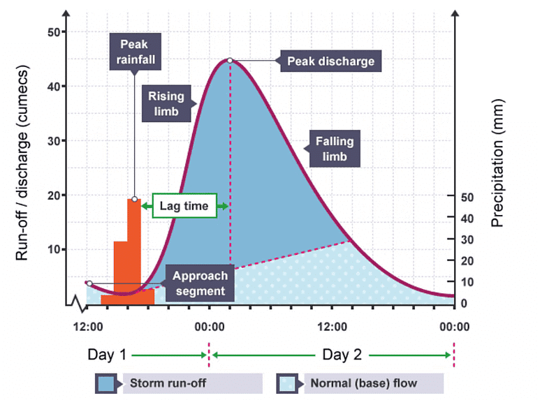
- The primary factor in evaluating flood risk is the lag time, which is the duration it takes for precipitation to reach the river from its point of origin.
- Rivers characterized by a short lag time and steep rising limbs face a heightened risk of flooding.
- In such cases, water swiftly reaches the river, potentially overwhelming its capacity to manage the influx.
- Conversely, rivers with a long lag time and gentle rising limbs experience lower flood risks.
- Here, water reaches the river more gradually, resulting in a steady increase in discharge.
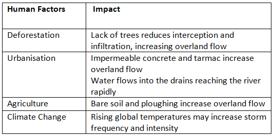
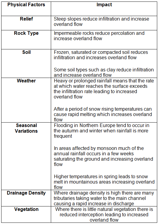
- The lag time is influenced by various human and natural factors, which contribute to increased overland flow, thereby shortening the lag time.
Human and Physical Factors which Increase the Risk of Flooding
MULTIPLE CHOICE QUESTIONTry yourself: Which factor plays a significant role in determining the risk of flooding in rivers?
Flood management
- The primary cause of flooding is the quantity and duration of precipitation, which is beyond alteration.
- Various methods exist for flood management aimed at mitigating severity and impact.
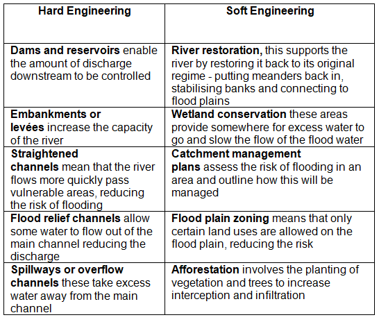
- Flood management strategies are typically categorized into two main types: hard and soft engineering.
- Hard engineering entails constructing infrastructure or altering the river course.
- Soft engineering, on the other hand, relies on natural river processes and the surrounding environment.
- Soft engineering methods are gaining popularity.
- Soft engineering exemplifies mitigation efforts, focusing on minimizing damage rather than entirely preventing flooding.
- Examples of Hard and Soft Engineering:
- Other methods that can be used to decrease the risk of flooding are:
- Retaining stubble on fields post-harvest aids in soil stabilization and enhances water infiltration.
- Contour plowing, where fields are plowed horizontally across slopes rather than vertically, prolongs water infiltration time and prevents plowed furrows from becoming water channels.
- Enhanced prediction systems and flood alerts improve forecasting accuracy and warning dissemination.
- Dredging rivers to boost capacity is another method, although it often necessitates reinforcing riverbanks with concrete.
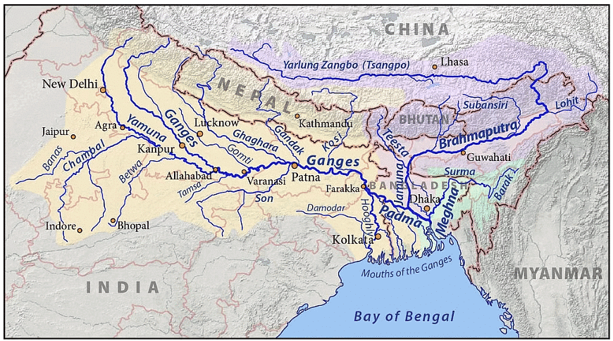
Case Study: Ganges/Brahmaputra
- The Ganges River spans a length of 2,510km, flowing through the countries of India and Bangladesh. In Bangladesh, it merges with the Brahmaputra River to form the River Padma.
- The Ganges' extensive drainage basin covers an area of 1.2 million square kilometers, supporting a population exceeding 650 million individuals.
- On the other hand, the Brahmaputra River stretches for 3,969 km, traversing through Tibet, India, and Bangladesh before converging with the River Padma.
- The Brahmaputra's drainage basin encompasses 651,334 square kilometers.
- Both rivers originate in the majestic Himalayan Mountains and eventually discharge their waters into the Bay of Bengal.
Opportunities
Water Supply
- Several cities, like New Delhi and Kolkata, rely on the Ganges/Brahmaputra rivers for their water sources.
Agriculture and Fishing
- The periodic flooding in the river basins results in nutrient-rich alluvial deposits, ideal for cultivating crops such as rice and jute.
- The rivers support irrigation needs and flooding of rice paddies.
- Fish sourced from the rivers not only provide sustenance but also create employment opportunities for locals.
Culture
- The Ganges holds deep religious significance for Hindus, revered as the goddess Ganga.
Tourism
- Key Hindu pilgrimage sites like Haridwar, Allahabad, and Varanasi are situated along the Ganges, attracting millions of visitors annually.
- Activities such as rafting and river cruises are gaining popularity among tourists.
Flat Land
- The flat nature of floodplains facilitates easy construction, leading to some of the highest population densities globally.
Energy
- Various dams, including the Tehri Dam on the Ganges, serve as significant hydroelectric power sources in India.
Hazards
- The Ganges/Brahmaputra drainage basin frequently encounters floods, with the most recent occurring in May 2022.
- In 1998, Bangladesh experienced severe flooding, affecting 75% of the country and displacing over 30 million individuals.
- The calamity resulted in over 1000 fatalities and the destruction of 700,000 hectares of crops.
- While routine floods are essential for soil fertility and irrigation, their predictability and scope are increasingly erratic.
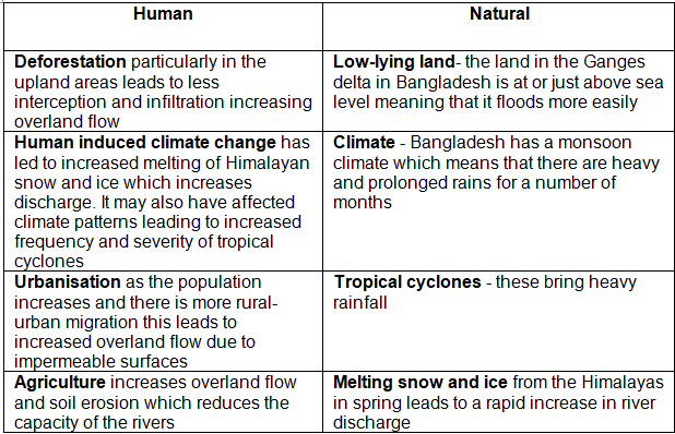
- The causes of flooding in the region are attributable to both human activities and natural phenomena, as outlined in the table below:
Management
- Bangladesh, classified as a Less Economically Developed Country (LEDC), faces financial constraints hindering large-scale flood mitigation projects.
- The Flood Action Plan (FAP) in Bangladesh, funded by the World Bank and several More Economically Developed Countries (MEDCs), aimed at mitigating flooding impacts. Key proposed measures included:
- Monitoring flood levels
- Constructing levées/embankments
- Building 5000 flood shelters
- Creating floodwater storage systems
- Implementing an enhanced flood warning system
- Building dams for water storage
- Addressing deforestation
- However, the FAP faced significant challenges and was deemed unsuccessful due to various reasons:
- Many planned components like dams and floodwater storage remained incomplete due to financial limitations and corruption.
- Realization emerged that some flooding was necessary for sustaining agriculture in several regions.
- Approximately 8 million individuals were displaced to facilitate FAP constructions.
- Altering upstream channels led to intensified flooding downstream.
- The government couldn't meet maintenance expenses.
- Current suggestions for better flood management involve:
- Enhanced flood forecasting and warning systems
- Establishing well-equipped flood shelters
- These strategies are more environmentally friendly and cost-effective compared to traditional hard engineering solutions like embankments and dams.
MULTIPLE CHOICE QUESTIONTry yourself: What are the two main types of flood management strategies?
The document River Management is a part of the Year 10 Course Geography for GCSE/IGCSE.
All you need of Year 10 at this link: Year 10
FAQs on River Management
| 1. What are the main factors that contribute to flooding in urban areas? |  |
Ans. Urban flooding can be caused by factors such as rapid urbanization leading to increased surface runoff, inadequate drainage systems, and the paving over of natural surfaces that would otherwise absorb water.
| 2. How can flood management help reduce the impact of flooding in urban areas? | |
Ans. Flood management strategies such as constructing flood barriers, creating green spaces to absorb excess water, and implementing proper land-use planning can help mitigate the impact of flooding in urban areas.
| 3. What are some methods that can be used to reduce the risk of flooding in rivers? | |
Ans. Some methods to reduce flooding risks in rivers include building flood embankments, implementing flood forecasting systems, and restoring natural floodplains to allow water to spread out.
| 4. How does the Ganges/Brahmaputra river system manage the risk of flooding in the region? | |
Ans. The Ganges/Brahmaputra river system uses strategies such as building embankments, dredging rivers to increase their capacity, and implementing early warning systems to manage the risk of flooding in the region.
| 5. How does effective water supply management contribute to reducing the impact of flooding in urban areas? | |
Ans. Proper water supply management can help reduce flooding in urban areas by ensuring that excess water is properly drained and not left to accumulate, thus preventing waterlogging and reducing the risk of flooding.
About this Document

4.71/5 Rating

Apr 29, 2026 Last updated
Related Exams
Document Description: River Management for Year 10 2026 is part of Geography for GCSE/IGCSE preparation. The notes and questions for River Management have been prepared according to the Year 10 exam syllabus. Information about River Management covers topics like and River Management Example, for Year 10 2026 Exam. Find important definitions, questions, notes, meanings, examples, exercises and tests below for River Management.
Introduction of River Management in English is available as part of our Geography for GCSE/IGCSE for Year 10 & River Management in Hindi for Geography for GCSE/IGCSE course. Download more important topics related with notes, lectures and mock test series for Year 10 Exam by signing up for free. Year 10: River Management
Description
River Management of Geography covers all the important topics, helping you prepare for the Year 10 exam on EduRev. Start for free!
Information about River Management
In this doc you can find the meaning of River Management defined & explained in the simplest way possible. Besides explaining types of River Management theory, EduRev gives you an ample number of questions to practice River Management tests, examples and also practice Year 10 tests


Related Searches
Important questions, video lectures, Free, Previous Year Questions with Solutions, Summary, shortcuts and tricks, Exam, pdf , Semester Notes, River Management, River Management, Viva Questions, past year papers, Objective type Questions, MCQs, practice quizzes, Extra Questions, study material, mock tests for examination, River Management, Sample Paper, ppt;