Class 10 Exam > Class 10 Notes > Geography for GCSE/IGCSE > Coastal Management
Coastal Management | Geography for GCSE/IGCSE - Class 10 PDF Download

Managing the Impacts of Coastal Erosion
- There are conflicting views about using a particular type of engineering for coastal defence
- Most coastal managers aim to use a range of methods depending on the value of what is being protected
- This method is known as Integrated Coastal Zone Management (ICZM)
- Integrated Coastal Zone Management (ICZM)
- ICMZ aims to use a combination of methods to best reflect all stakeholder's needs
Soft Engineering for Coastal Protection
- Soft engineering aligns with natural processes instead of working against them.
- It is generally more cost-effective and does not harm the coastal aesthetics.
- Considered a sustainable approach to coastal protection, although less effective than hard engineering methods.
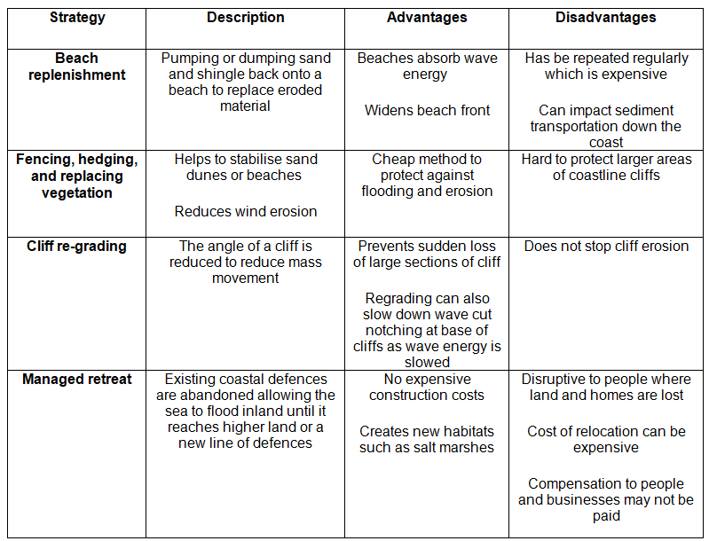
Soft Engineered Defences:
Question for Coastal ManagementTry yourself: What is the main advantage of using soft engineering for coastal protection?View Solution
Hard Engineering Methods
- Hard engineering entails constructing sea defenses typically using materials like concrete, wood, or rock.
- These structures are costly to build and require regular maintenance.
- They function in opposition to wave forces, each type having specific strengths and weaknesses.
- Protecting one area may lead to accelerated erosion and flooding in neighboring regions.
- Hard engineering is employed when valuable settlements or installations are threatened, with economic benefits outweighing construction costs.
Hard Engineered Defences: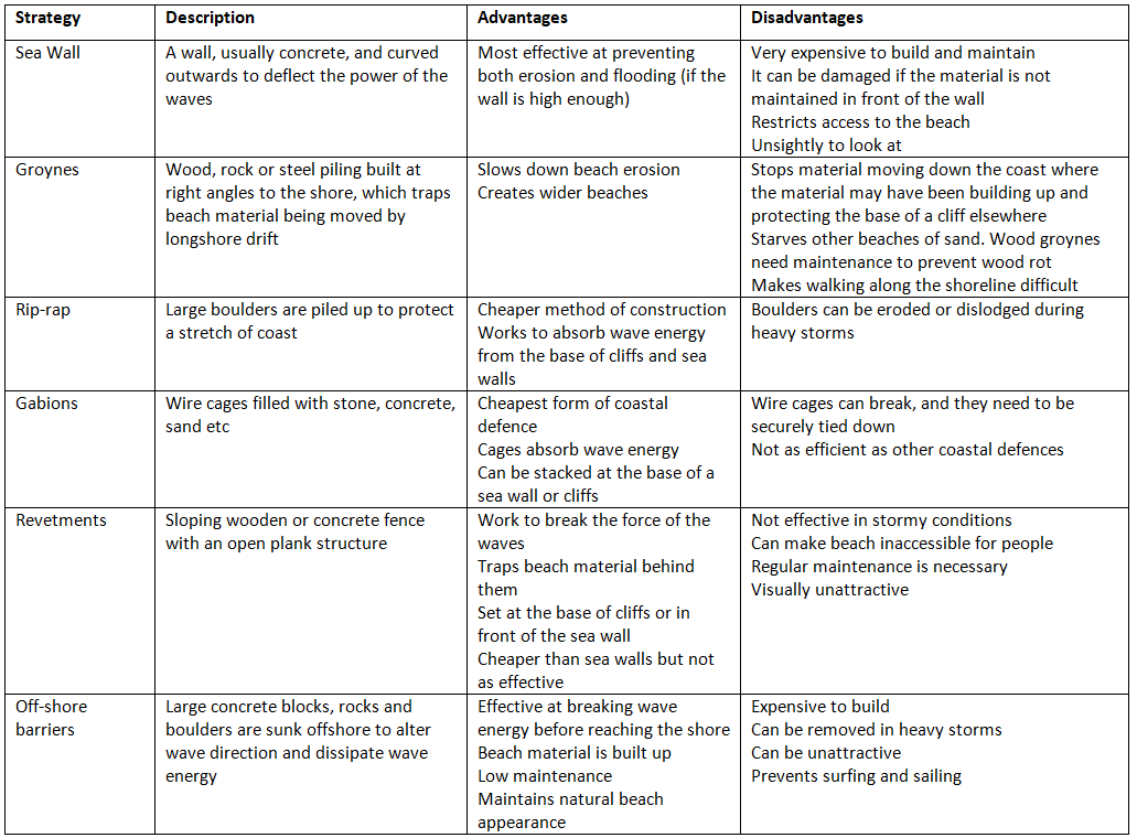
Prediction
- Early warning systems enable communities to prepare for flooding by facilitating evacuation or taking shelter before the event.
- Two primary methods aid in forecasting coastal flooding:
a. Historical records, including diaries, newspapers, and government/council archives, which identify flood-prone areas and their frequency.
b. Modern technologies like GIS, satellites, computer monitoring, and weather stations (local and national), allowing for forecasting and tracking of potential hazard events such as:- Tropical storms: Tracking the storm's path and associated storm surge.
- Earthquakes: Determining size, position, and potential tsunami outcomes if underwater.
- Both forecasting methods assist officials in determining when and where the event will occur.
- They also provide insights into the potential strength and scale of flooding, as well as the likelihood of damage and fatalities.
Prevention
- Flood defences are constructed along high-risk coastal stretches to mitigate flooding.
- Emergency centers are strategically located on higher ground to provide safety for people during flooding events.
- Early warning systems enable preparation or evacuation of vulnerable areas.
- Education initiatives inform local residents about appropriate actions to take in the event of a flood.
- Planning measures involve avoiding new developments in high-risk areas and designing buildings to withstand flooding:
a. Designing buildings with elevated foundations to allow floodwaters to pass underneath.
b. Flood-proofing buildings through raised foundations, reinforced barriers, and sealing properties to prevent floodwater ingress.
c. Employing dry flood-proofing methods to seal properties from floodwater intrusion.
d. Implementing wet flood-proofing techniques to allow controlled flooding within buildings. - Buffer zones are designated areas of land that can flood before reaching settlements, dissipating the energy of surges and reducing floodwater travel distance.
- However, relocating people away from the coast to establish buffer zones can be a contentious issue.
Coastal Strategies
- Coastal regions are managed through the identification of coastal cells, which divide lengthy coastlines into manageable segments. This approach assists in pinpointing two critical risks: the threat of erosion and land retreat, as well as the risk of flooding.
- The division of coastlines into coastal cells aids in pinpointing risks like erosion, land retreat, and flooding, allowing for more effective resource allocation to mitigate these dangers.
- Resource allocation is optimized through the identification of coastal cells, streamlining the process of calculating the cost-to-benefit ratio for various shoreline management initiatives.
Shoreline Management Plans (SMP)
- Shoreline Management Plans (SMP) outline strategies for safeguarding coastlines from flooding and erosion risks.
- The primary goal of SMP is to minimize risks to individuals, communities, agricultural areas, and natural habitats like salt marshes.
Approaches for Coastal Management
There are four distinct strategies for coastal management, each with varying costs and outcomes:
- Hold the Line: This long-term strategy involves maintaining existing coastal defenses to prevent shoreline retreat. It primarily relies on hard engineering, supported by soft engineering methods.
- Advance the Line: This approach entails constructing new defenses to extend the shoreline, involving land reclamation and a combination of hard and soft engineering techniques.
- Managed Realignment: In this method, the coastline is allowed to shift naturally, with monitoring and intervention as needed. It predominantly employs soft engineering measures with some hard engineering support.
- Do Nothing: The least expensive but controversial option where the coast is left to erode without intervention, considering factors like economic, engineering constraints, cultural and ecological significance, community sentiments, and social value.
Factors Influencing Decision-Making
Deciding on a coastal management approach involves intricate considerations such as:
- Economic Value: Assessing the value of resources at risk, like land and property.
- Engineering Feasibility: Recognizing limitations in implementing certain strategies based on geological dynamics.
- Cultural and Ecological Importance: Protecting heritage sites and biodiversity-rich areas.
- Community and Social Factors: Considering local activism, historic ties, and communal well-being.
Coastal Defence Strategies
- Building New Defences
- Utilizing a combination of Hard and Soft Engineering
- Implementing Land Reclamation
Managed Realignment
- Allowing the coastline to shift naturally
- Monitoring and directing processes as needed
- Emphasizing a natural approach to coastal defense
- Primarily employing soft engineering methods with some hard engineering support
Do Nothing Approach
- Considered the cheapest method but highly debated
- Letting the coast erode and move inland
- Choosing not to invest in protecting the coastline or preventing flooding
Factors Influencing Decision-making
- Economic considerations such as the value of resources like land and homes
- Engineering limitations, especially in challenging terrains
- Cultural and ecological significance of the land
- Community demands and social importance of regions
Factors Influencing Coastal Management
- Economic Value of Protected Resources: This includes the economic worth of safeguarded assets like land and homes.
- Engineering Solutions: In some cases, it may be challenging to maintain stability for dynamic landforms such as spits or precarious cliffs.
- Cultural and Ecological Significance: Preserving historical sites and regions of unique biodiversity is crucial.
- Community Advocacy: Local movements play a significant role in advocating for the protection of coastal areas.
- Social Importance of Communities: Recognizing the enduring value of established and historic communities.
Question for Coastal ManagementTry yourself: What is the purpose of early warning systems in coastal areas?View Solution
Case Study - Super Typhoon Haiyan
Background
- Typhoon Haiyan, known locally as Yolanda, stands out as one of the most powerful tropical storms ever documented in the history of the Philippines.
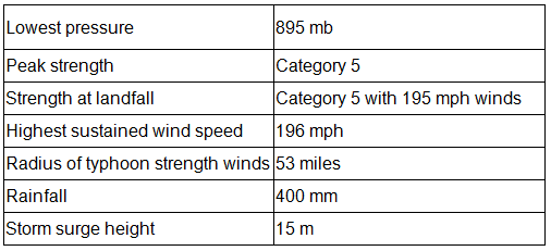
- On the 8th of November 2013, this catastrophic event made landfall as a Category 5 typhoon, exhibiting sustained winds exceeding 195 mph (315 km/hr).
- Situated in the South China Sea, east of Vietnam and north of Indonesia, the Philippines consist of a cluster of islands prone to annual typhoons approaching from the southwest during the tropical storm season.
- Despite being located in warm ocean waters, during the storm, the sea temperature was recorded at 30°C.
- Over the years, global sea levels have risen by 20cm since 1900, a phenomenon that significantly contributes to heightened storm surges.
- Excessive extraction of groundwater has led to certain areas of the country experiencing subsidence, exacerbating the impact of natural calamities.
- Tacloban, positioned at the bay's terminus with a funnel-like shape, amplifies the force of storm surges, resulting in devastating consequences.
Tropical Storm Formation
- All tropical storms require warm, deep waters (above 27°C and deeper than 70 meters) along with the Coriolis force generated by the Earth's rotation. This combination typically leads to their formation between 5-20 degrees north and south of the equator.
- Warm ocean waters facilitate evaporation from the surface. As the warm, moist air rises, it cools, condenses, and releases latent heat, forming massive thunderclouds.
- The heat from below intensifies vertical growth, resulting in the development of an intense low-pressure system.
- Tropical storms often originate from the merging of multiple storm systems on the eastern side of an ocean.
- A significant low-pressure center emerges, drawing in winds that initiate a counterclockwise spin, moving westward.
- Within the storm, winds revolve around a calm center known as the eye, where descending cold air creates a tranquil zone.
- The most potent winds are typically found within the eyewall of the storm.
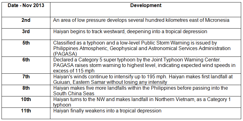
Typhoon Haiyan's timeline:
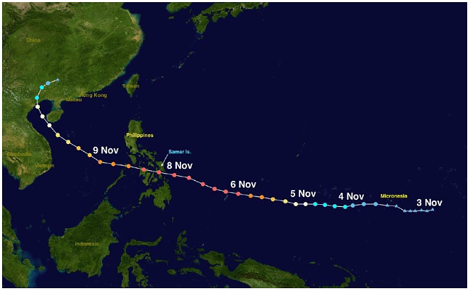
Path of Typhoon Haiyan November 2013
Typhoon Haiyan's characteristics
Preparation for Typhoon Haiyan
- Despite being classified as a Less Economically Developed Country (LEDC), the Philippines takes disaster preparedness seriously due to its frequent exposure to typhoons, often being the first landmass in a typhoon's path.
- The Philippines has a long history of practicing risk reduction and resilience measures, including the publication of risk maps and the establishment of evacuation shelters.
- During Typhoon Haiyan, the International Charter on Space and Major Disasters was activated, granting relief agencies access to satellite data to aid in relief and recovery efforts.
- The military proactively deployed aircraft to areas expected to be severely affected by the typhoon.
- Community buildings like convention centers were designated as storm shelters, although concerns arose regarding their ability to withstand strong winds.
- Due to years of community preparedness and education, entire islands such as Tulang Diyot were successfully evacuated, with all 1000 residents leaving before Haiyan's arrival.
- In 2011, a local mayor received recognition for community work based on the "Purok system," where community members contribute their own funds regularly to a communal pool for post-disaster assistance, reducing reliance on government aid.
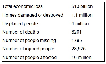
Impacts of Haiyan
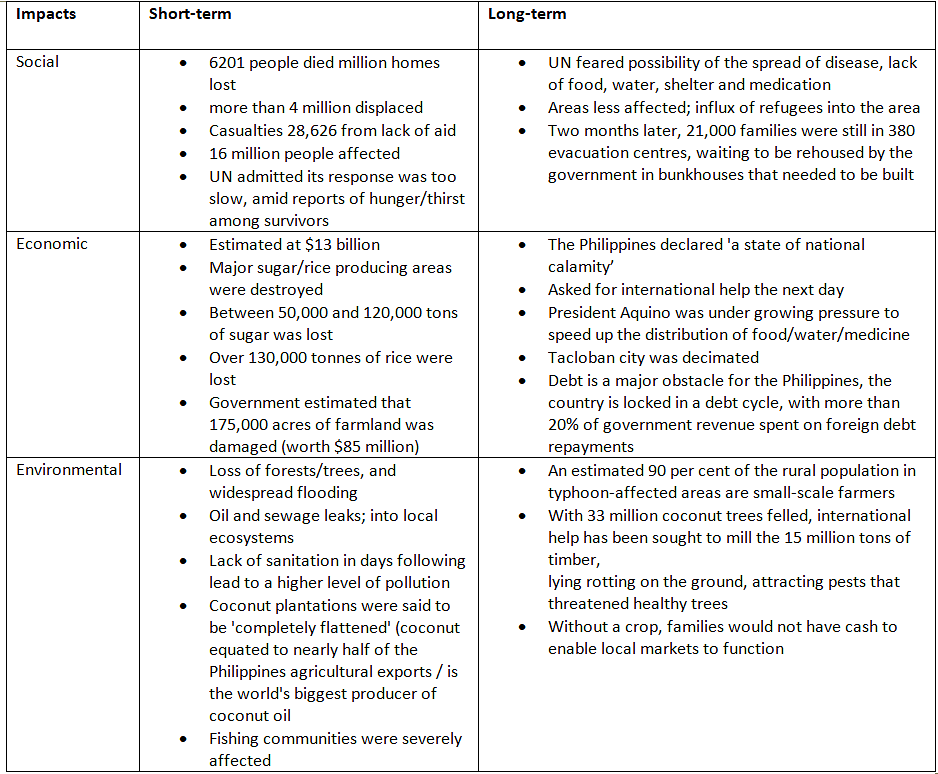
Immediate relief
- The initial reaction came from survivors, who combed through collapsed buildings in search of bodies.
- Criticism was directed at the government for the perceived slowness of its response, leading to instances of looting by people in search of food supplies.
- While the roads remained intact, the presence of debris impeded the progress of rescue vehicles.
- Closure of airports and harbors forced emergency teams to travel on foot, hindering the distribution of aid.
- International aid organizations dispatched emergency provisions, focusing on Tacloban airport. Countries like the UK and USA contributed essential equipment like diggers and heavy lifting gear.
- The European Commission allocated $4 million in emergency funds, while the UK Rapid Response Facility extended $8 million in assistance.
- Twelve Emergency Response Units from the International Federation of the Red Cross (IFRC) were mobilized globally.
- Prior to the typhoon, the Philippines had already been grappling with the aftermath of a 7.3 magnitude earthquake in October 2013 and Typhoon Bopha in 2012. These successive disasters had drained the country's resources—financial, material, and human.
The document Coastal Management | Geography for GCSE/IGCSE - Class 10 is a part of the Class 10 Course Geography for GCSE/IGCSE.
All you need of Class 10 at this link: Class 10
|
55 videos|68 docs|78 tests
|
FAQs on Coastal Management - Geography for GCSE/IGCSE - Class 10
| 1. What are some examples of soft engineering methods for coastal protection? |  |
Ans. Soft engineering methods for coastal protection include beach nourishment, dune stabilization, marsh creation, and mangrove planting.
| 2. What are some examples of hard engineering methods used to manage coastal erosion? | |
Ans. Hard engineering methods for coastal erosion include sea walls, groynes, breakwaters, and offshore reefs.
| 3. What are some coastal strategies that can be implemented to manage the impacts of coastal erosion? | |
Ans. Coastal strategies include dune restoration, managed retreat, beach reprofiling, and sustainable coastal development.
| 4. What is the significance of Shoreline Management Plans (SMP) in coastal management? | |
Ans. Shoreline Management Plans (SMP) provide a comprehensive approach to managing coastal erosion and flooding, taking into account environmental, social, and economic factors.
| 5. How did Super Typhoon Haiyan impact coastal areas and what measures were taken to manage its aftermath? | |
Ans. Super Typhoon Haiyan caused severe coastal erosion and flooding in the Philippines, leading to the implementation of coastal protection measures such as mangrove restoration and improved early warning systems.
About this Document

Oct 24, 2025
Last updated
Related Exams
Document Description: Coastal Management for Class 10 2025 is part of Geography for GCSE/IGCSE preparation.
The notes and questions for Coastal Management have been prepared according to the Class 10 exam syllabus. Information about Coastal Management covers topics
like Managing the Impacts of Coastal Erosion, Soft Engineering for Coastal Protection, Hard Engineering Methods, Coastal Strategies, Shoreline Management Plans (SMP), Case Study - Super Typhoon Haiyan and Coastal Management Example, for Class 10 2025 Exam. Find important definitions, questions, notes, meanings, examples, exercises and tests below for Coastal Management.
Introduction of Coastal Management in English is available as part of our Geography for GCSE/IGCSE
for Class 10 & Coastal Management in Hindi for Geography for GCSE/IGCSE course.
Download more important topics related with notes, lectures and mock test series for Class 10
Exam by signing up for free. Class 10: Coastal Management | Geography for GCSE/IGCSE - Class 10
Description
Full syllabus notes, lecture & questions for Coastal Management | Geography for GCSE/IGCSE - Class 10 - Class 10 | Plus excerises question with solution to help you revise complete syllabus for Geography for GCSE/IGCSE | Best notes, free PDF download
Information about Coastal Management
In this doc you can find the meaning of Coastal Management defined & explained in the simplest way possible. Besides explaining types of
Coastal Management theory, EduRev gives you an ample number of questions to practice Coastal Management tests, examples and also practice Class 10
tests

Related Searches
Free
,MCQs
,Objective type Questions
,practice quizzes
,mock tests for examination
,past year papers
,Important questions
,Exam
,Semester Notes
,Coastal Management | Geography for GCSE/IGCSE - Class 10
,shortcuts and tricks
,Coastal Management | Geography for GCSE/IGCSE - Class 10
,Extra Questions
,Viva Questions
,ppt
,Previous Year Questions with Solutions
,Summary
,video lectures
,Sample Paper
,study material
,Coastal Management | Geography for GCSE/IGCSE - Class 10
,


Additional Information about Coastal Management for Class 10 Preparation
Coastal Management Free PDF Download
The Coastal Management is an invaluable resource that delves deep into the core of the Class 10 exam.
These study notes are curated by experts and cover all the essential topics and concepts, making your preparation more efficient and effective.
With the help of these notes, you can grasp complex subjects quickly, revise important points easily,
and reinforce your understanding of key concepts. The study notes are presented in a concise and easy-to-understand manner,
allowing you to optimize your learning process. Whether you're looking for best-recommended books, sample papers, study material,
or toppers' notes, this PDF has got you covered. Download the Coastal Management now and kickstart your journey towards success in the Class 10 exam.
Importance of Coastal Management
The importance of Coastal Management cannot be overstated, especially for Class 10 aspirants.
This document holds the key to success in the Class 10 exam.
It offers a detailed understanding of the concept, providing invaluable insights into the topic.
By knowing the concepts well in advance, students can plan their preparation effectively.
Utilize this indispensable guide for a well-rounded preparation and achieve your desired results.
Coastal Management Notes
Coastal Management Notes offer in-depth insights into the specific topic to help you master it with ease.
This comprehensive document covers all aspects related to Coastal Management.
It includes detailed information about the exam syllabus, recommended books, and study materials for a well-rounded preparation.
Practice papers and question papers enable you to assess your progress effectively.
Additionally, the paper analysis provides valuable tips for tackling the exam strategically.
Access to Toppers' notes gives you an edge in understanding complex concepts.
Whether you're a beginner or aiming for advanced proficiency, Coastal Management Notes on EduRev are your ultimate resource for success.
Coastal Management Class 10 Questions
The "Coastal Management Class 10 Questions" guide is a valuable resource for all aspiring students preparing for the
Class 10 exam. It focuses on providing a wide range of practice questions to help students gauge
their understanding of the exam topics. These questions cover the entire syllabus, ensuring comprehensive preparation.
The guide includes previous years' question papers for students to familiarize themselves with the exam's format and difficulty level.
Additionally, it offers subject-specific question banks, allowing students to focus on weak areas and improve their performance.
Study Coastal Management on the App
Students of Class 10 can study Coastal Management alongwith tests & analysis from the EduRev app,
which will help them while preparing for their exam. Apart from the Coastal Management,
students can also utilize the EduRev App for other study materials such as previous year question papers, syllabus, important questions, etc.
The EduRev App will make your learning easier as you can access it from anywhere you want.
The content of Coastal Management is prepared as per the latest Class 10 syllabus.
|
© EduRev
|
Education Revolution
|


|


Signup to see your scores
go up within 7 days!
Access 1000+ FREE Docs, Videos and Tests
Takes less than 10 seconds to signup