IGCSE Year 10 > Year 10 Notes > Geography for GCSE/ > Maps
Maps

Maps
Questions in the exam will be based on topographical maps.
- The maps can be from anywhere in the world.
- Maps will have a key, scale, northings, and eastings.
- These elements must be utilized to answer the questions.
Grid references
4-Figure Grid References
- 4-figure references are utilized to identify specific grid squares on a map.
- First two figures: Eastings - show east or west position on the map.
- Second two figures: Northings - indicate north or south position on the map.
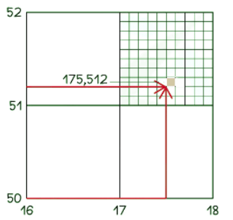
6-Figure Grid References
- 6-figure references are employed to pinpoint exact points within grid squares.
- First three figures: Eastings - specify east or west location on the map.
- Last three figures: Northings - determine north or south location on the map.
To find a 4 and 6 figure grid reference
- To determine a 4-figure grid reference, provide the number from the bottom of the map first, followed by the number from the side of the map.
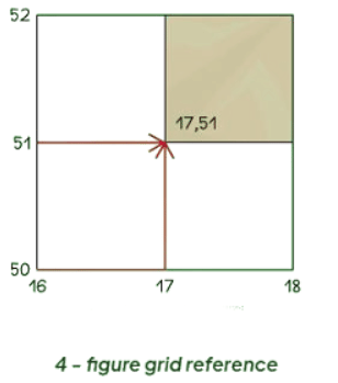
- In the image above, the 4-figure grid reference would be 17, 51. To give the 6-figure grid reference, you need to imagine that the grid square is divided into 100 smaller squares.
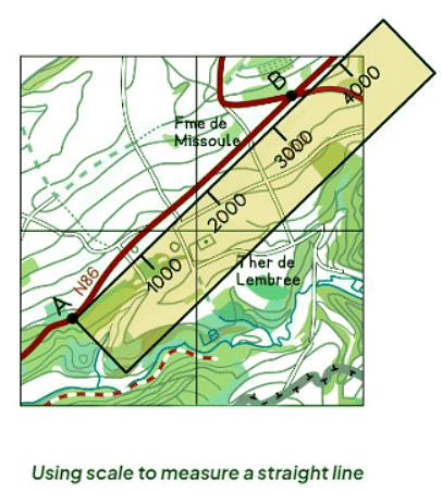
Scale
- Maps in the exam will either be scale 1:25,000 where 1cm on the map = 25,000cm (250m) in real life or 1:50,000 where 1cm = 50,000cm (500m) in real life
- When the distance is straight or almost straight, it can be measured using a ruler or the edge of a straight piece of paper
- Using the scale at the bottom of the map, mark distances on a piece of paper
- This marked paper can then be laid from the first point to the second point to calculate the distance
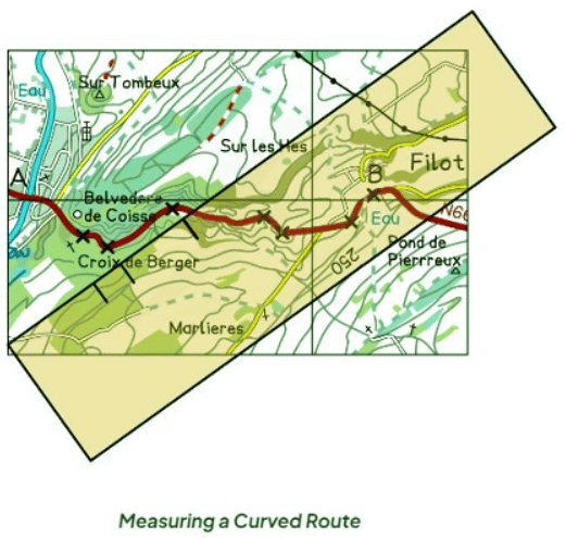
- A distance along a curved route can be divided; the paper can be rotated and marked in stages to calculate the full distance
- To measure from point A to point B following the road on the map, the route can be divided into a series of straight sections using crosses
- The plain piece of paper can then be used to measure from point A to the first cross, and then rotated at the cross to mark the second cross
MULTIPLE CHOICE QUESTIONTry yourself: What do the first two figures in a 4-figure grid reference represent?
Bearings
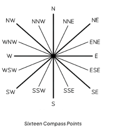
- Directions on a map should always be provided using compass points.
- There are a total of 16 compass points.
- A grid bearing is measured from grid north at 0 degrees. East corresponds to 90 degrees, South to 180 degrees, and West to 270 degrees.
- Grid bearings are determined using a protractor where 0 degrees should align with north. The center of the protractor indicates the direction from which the bearing is given.
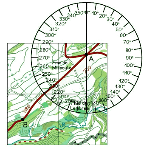
- On the map, location B lies to the South West of point A, indicated by a bearing of 280 degrees.
Heights
- Height representation on maps can be achieved through three primary methods:
- Spot Heights
- Contour Lines
- Trigonometrical Stations
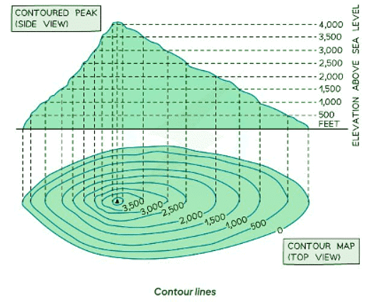
- Spot Heights: These indicate the height at a specific point, with the measurement provided next to it.
- Contour Lines: These are isolines connecting points of equal height, typically at 5 or 10-meter intervals. The spacing between contour lines signifies an increase in land height by 5 or 10 meters.
- Trigonometrical Stations: Represented by small black triangles with accompanying height measurements.
Topography
- Contour lines play a crucial role in representing the shape and slope of the land or topography.
- When contour lines are closely packed together, it signifies steep terrain, whereas lines that are spaced far apart indicate gently sloping or flat land, depending on the distance between them.
- V-shaped valleys are characterized by a set of V-shaped contours, providing insight into the landscape's features.
- A hill's presence is depicted by circular contour lines encircling it.
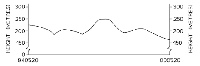
Cross-sections
- A cross-section serves as a slice through the landscape, aiding in understanding land features.
- On maps, cross-sections are represented by labeled lines, such as A and B, utilizing contour lines to assess land elevation.
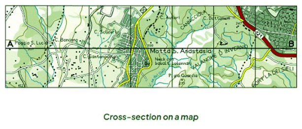
- To determine height accurately, a paper is placed along the line, marking points A and B, with contour lines being noted each time they intersect the paper.
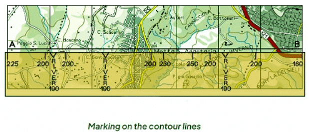
- These figures can then be used to create the cross-section
Key
- Maps are effective tools for recognizing various landscape characteristics.
- These features encompass both physical and human aspects.
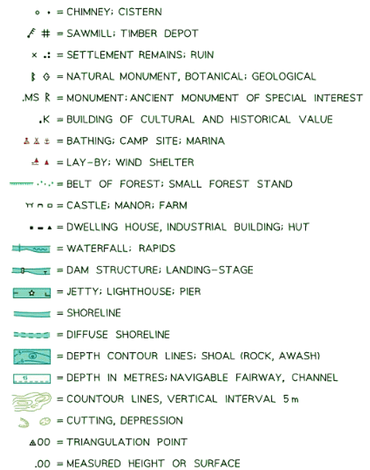
- Each map includes a legend or key to explain the symbols used and their meanings.
MULTIPLE CHOICE QUESTIONTry yourself: Which method is used to represent the height at a specific point on a map?
The document Maps is a part of the Year 10 Course Geography for GCSE/IGCSE.
All you need of Year 10 at this link: Year 10
FAQs on Maps
| 1. What is a grid reference on a map? |  |
Ans. A grid reference on a map is a numerical way of identifying a specific location on a map using a grid system. It consists of two numbers representing the easting and northing coordinates.
| 2. How do you read a grid reference on a map? | |
Ans. To read a grid reference on a map, start by looking at the bottom left-hand corner of the map to find the grid lines. Then, locate the easting coordinate first followed by the northing coordinate to pinpoint the exact location on the map.
| 3. Why are grid references important when using maps? | |
Ans. Grid references are important when using maps because they provide a precise way of communicating and locating specific points on a map. They help in navigation, search and rescue operations, and accurately sharing locations with others.
| 4. What are the different types of grid references used on maps? | |
Ans. The two main types of grid references used on maps are 4-figure grid references and 6-figure grid references. 4-figure references give a general location within a 1 km square, while 6-figure references provide a more precise location within a 100 m square.
| 5. How can grid references be used in orienteering or navigation activities? | |
Ans. Grid references are crucial in orienteering or navigation activities as they help participants locate checkpoints or specific locations accurately on a map. By understanding how to read and use grid references, individuals can navigate through unfamiliar terrain with ease.
About this Document

4.82/5 Rating

Apr 20, 2026 Last updated
Related Exams
Document Description: Maps for Year 10 2026 is part of Geography for GCSE/IGCSE preparation. The notes and questions for Maps have been prepared according to the Year 10 exam syllabus. Information about Maps covers topics like and Maps Example, for Year 10 2026 Exam. Find important definitions, questions, notes, meanings, examples, exercises and tests below for Maps.
Introduction of Maps in English is available as part of our Geography for GCSE/IGCSE for Year 10 & Maps in Hindi for Geography for GCSE/IGCSE course. Download more important topics related with notes, lectures and mock test series for Year 10 Exam by signing up for free. Year 10: Maps
Description
Maps of Geography covers all the important topics, helping you prepare for the Year 10 exam on EduRev. Start for free!
Information about Maps
In this doc you can find the meaning of Maps defined & explained in the simplest way possible. Besides explaining types of Maps theory, EduRev gives you an ample number of questions to practice Maps tests, examples and also practice Year 10 tests


Related Searches
ppt, Free, Maps, Maps, study material, shortcuts and tricks, Maps, Previous Year Questions with Solutions, Summary, pdf , Sample Paper, video lectures, past year papers, Viva Questions, practice quizzes, Extra Questions, Semester Notes, Exam, mock tests for examination, Objective type Questions, MCQs, Important questions;