Textbook Solution: The Earth and Its Atmosphere | IGCSE Cambridge Science for Year 7 - Class 7 PDF Download
| Table of contents |

|
| The Earth's Crust |

|
| Earthquakes, Volcanoes and Mountains |

|
| The Earth's Atmosphere |

|
| The Water Cycle |

|
| End of the Chapter Review |

|
The Earth's Crust
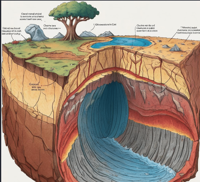
Q1. Draw a sketch diagram that shows a cross-section of the Earth’s crust. Show the difference in thickness between crust that is under ocean and crust on 'dry land'.
Ans: To create a sketch of the Earth's crust, you would draw a cross-section showing two types of crust: oceanic and continental. The oceanic crust, found under oceans, is thinner (about 5-10 km thick) and denser, mostly composed of basalt. The continental crust, found under dry land, is thicker (about 30-50 km thick) and less dense, primarily composed of granite and sedimentary rocks.
Q2. Suggest why we can only 'think' that the core is made from iron and nickel. Is it possible to prove it?
Ans: We think the Earth's core is made of iron and nickel based on indirect evidence such as the behavior of seismic waves, the Earth's density, and its magnetic field. Direct sampling of the core is currently impossible due to its extreme depth and temperature, so while the evidence strongly supports this composition, it cannot be directly proven with current technology.
Q3. List three items of evidence that supported Wegener’s hypothesis.
Ans: Three key pieces of evidence for Wegener's hypothesis of continental drift include: (1) the fit of the continents, such as how the east coast of South America and the west coast of Africa appear to fit together; (2) fossil evidence showing that the same species of extinct plants and animals are found on continents now separated by oceans; and (3) similar rock formations and mountain ranges lining up across continents.
Q4. Imagine that you were one of the scientists who had investigated rocks on different continents and found they were similar. Write a conclusion that:
i) includes Wegener's hypothesis
ii) describes how the evidence of rocks supports it.
Ans i):
Alfred Wegener proposed the hypothesis of continental drift, which suggests that the continents were once part of a single large landmass, called Pangaea. Over millions of years, this landmass broke apart, and the continents slowly drifted to their current positions. Wegener's hypothesis was based on several lines of evidence, including the similarity of rock formations, fossil records, and the fit of the continents.
Ans ii):
Evidence of Rocks Supporting Wegener's Hypothesis
Rock Formations:
Similar rock types and structures on different continents, such as mountain ranges in South America and Africa, indicate these continents were once connected.
Age and Composition:
Rocks of the same age and composition, like those in Canada and Scandinavia, suggest a shared origin, supporting the idea of a past supercontinent.
Fossil Distribution:
Identical fossils, such as those of Mesosaurus, found in South America and Africa, indicate these continents were once joined.
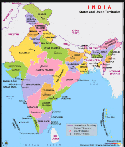
Q5. Find India on the map in figure 10.4b. Name the plate on which India is found and state the direction it is moving in.
Ans: India is located on the Indian Plate. This plate is moving northward, which is evident from its collision with the Eurasian Plate, leading to the uplift of the Himalayan mountain range.
Q6. Two sets of tectonic plates meet along a line that runs approximately down the centre of the Atlantic Ocean. Is this where plates are moving together or moving apart? What is your evidence?
Ans: The tectonic plates along the mid-Atlantic Ridge are moving apart. This is evidenced by the process of seafloor spreading, where magma rises from the mantle, creating new oceanic crust and pushing the plates on either side outward.
Q7. One tectonic plate moves at an average speed of 5 cm in one year. Estimate how far the plate has moved in 100 million years. State your answer in km and describe any assumptions you have made.
Ans: If a plate moves at 5 cm per year, in 100 million years, it would move 5,000 km. This calculation assumes a constant movement rate over the entire period.
Earthquakes, Volcanoes and Mountains
Q1. Figure 10.6b shows one plate being pushed down by another as the two move towards each other. Describe how an earthquake can be caused in this situation.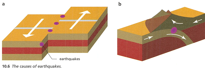
Ans: In the scenario depicted in Figure 10.6b, an earthquake can occur due to the subduction of one tectonic plate beneath another. As the two plates converge, the denser plate gets pushed down into the mantle. This process generates significant stress and friction along the boundary between the two plates. Over time, the stress accumulates until it exceeds the strength of the rocks, causing the rocks to break or slip. The sudden release of energy from this slip is what causes an earthquake.
Q2. Describe how an earthquake can produce a tsunami.
Ans: An earthquake can generate a tsunami when it occurs under the ocean or near the ocean floor, leading to a sudden displacement of water. This displacement happens when the seabed abruptly deforms and vertically displaces the overlying water. The energy from the earthquake propels the water into waves that travel across the ocean basin at high speeds. These waves can grow in height as they approach shallower waters near coastlines, resulting in potentially devastating tsunamis.
Q3. Look at figure 10.9, which is a simplified diagram of how the tsunami spread outwards from the Indonesian earthquake. Estimate how long it took the tsunami to reach Sri Lanka.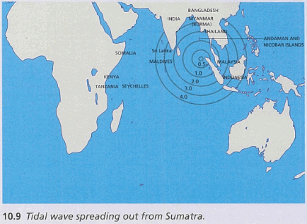
Ans: Referring to figure 10.9, the circles indicate the tsunami wave spread at intervals of 20 minutes, and Sri Lanka is approximately covered by the 2.0-hour circle. Thus, it is estimated that it took about 2 hours for the tsunami waves generated by the earthquake near Indonesia to reach the shores of Sri Lanka.
Q4. Suggest two strengths of the computer models that scientists use to predict earthquakes.
Ans: One strength of computer models used in earthquake prediction is their ability to integrate vast amounts of geological and seismic data to assess earthquake risks more accurately. Another strength is their capacity to simulate different earthquake scenarios, which helps in preparing for potential earthquakes by improving emergency responses and infrastructure resilience.
Q5. A tsunami early warning system would not have helped people in the town of Aceh on the coast of Indonesia. Explain why.
Ans: A tsunami early warning system might not have been effective in Aceh because the proximity of the earthquake's epicenter to Aceh allowed very little time for a warning to be issued and for people to evacuate. The tsunami waves would have reached Aceh very shortly after the earthquake, possibly within minutes, making it challenging to respond quickly enough to mitigate the disaster's impact.
Q6. State the name given to liquid rock that occurs beneath the surface.
Ans: The name given to liquid rock that occurs beneath the Earth's surface is magma.
Q7. Hot rock that flows on the surface is called lava. Describe what happens to this lava as it spreads out over the ground.
Ans: As lava spreads out over the ground, it cools and solidifies to form igneous rock. The speed at which it cools and the characteristics of the lava, such as its viscosity, determine the texture and formation of the rock. Lava can also create various landforms, such as lava plains, plateaus, or volcanic cones, depending on its volume, flow rate, and the area's topography.
Q8. The Cascade Mountains along the western coast of the northern United States contain active volcanoes such as Mount Rainier and Mount St. Helens. Suggest how these volcanoes may have formed.
Ans: The volcanoes in the Cascade Mountains may have formed due to the subduction of the Juan de Fuca Plate beneath the North American Plate. As the oceanic plate subducts, it melts due to the high temperatures and pressures in the mantle, leading to the formation of magma. This magma rises to the surface and erupts to form volcanoes. This process is part of the Pacific Ring of Fire, known for its frequent volcanic and seismic activity.
Q9. The islands of Hawaii contain active volcanoes. They are in the middle of the Pacific plate, not at a plate boundary. Suggest how the islands formed.
Ans: The Hawaiian Islands formed due to volcanic activity above a hot spot in the Earth's mantle. In this region, plumes of hot magma rise from deep within the mantle to the surface, creating volcanoes. Over millions of years, these volcanoes have built up layers of lava that emerge above the ocean surface as islands. As the Pacific Plate moves over the stationary hot spot, new islands can form, leading to a chain of islands like the Hawaiian archipelago.
Q10. Suggest why 'fold mountains' are given this name.
Ans: Fold mountains are given this name because they are primarily formed by the folding of the Earth's crust. This folding occurs when tectonic plates collide and their edges are pushed upwards, forming a series of folds that appear as mountain ranges. The process involves the compression of rocks, which buckle and fold under the immense pressure, creating the characteristic rugged mountain landscapes.
Q11. Explain why fold mountains are not formed at a plate boundary where the plates are moving apart.
Ans: Fold mountains are not formed at divergent plate boundaries, where plates are moving apart, because this type of boundary typically involves the stretching and thinning of the Earth's crust rather than compressive forces that create folds. At divergent boundaries, magma rises from the mantle to fill the space created by the separating plates, often forming new crust and volcanic activity rather than mountain ranges.
Q12. Early forms of life from hundreds of millions of years ago lived in the oceans. We know about them because fossils of these living things have been found high up in fold mountains. Explain how fossils of sea creatures can be found near the tops of mountains.
Ans: Fossils of sea creatures are found near the tops of fold mountains due to the geological process known as uplift, associated with the folding of the Earth's crust during the formation of these mountains. As tectonic plates collided and the sea floor was uplifted, areas that were once underwater became elevated into mountainous regions. Over time, the sedimentary layers containing these fossils were exposed at high altitudes, providing evidence of the mountain's marine origins.
The Earth's Atmosphere
Q1. Copy and complete this reaction equation for the gas syringe experiment.
copper + ........................... ➔ ........................
Ans: copper + oxygen → copper oxide
Q2. Why is it important that the air used for the reaction is dry?
Ans: It is important that the air is dry to prevent water vapor from interfering with the reaction or the measurements, ensuring that only the desired reactants interact and that the results are accurate.
Q3. The product of the reaction is a solid, not a gas. Explain why this is important for making measurements.
Ans: The solid product allows for easier measurement of mass before and after the reaction, facilitating accurate calculations of the reactants' and products' masses, which is crucial for stoichiometry and conservation of mass experiments.
Q4.
a) State two pieces of evidence that the atmosphere
must contain water particles.
b) Dry air has had the water taken out of it. When we compare the mixture of gases in the air over time or in different places, we usually talk about dry air. Suggest one reason why ?
Ans:
(a) Evidence that the Atmosphere Contains Water Particles
Humidity and Condensation: High humidity levels leading to condensation into clouds, fog, or dew.
Precipitation: Rain, snow, sleet, and hail are forms of precipitation originating from water particles in the atmosphere.
(b) Reason for Comparing Mixtures of Gases in Dry Air
Reason: Comparing the mixture of gases in dry air standardizes the composition without the variable of water vapor, allowing for consistent and accurate analysis of the main gases in the atmosphere.
Ans: Approximately 78% of the air is nitrogen gas.
Q6. Explain the difference between accuracy and reliability.
Ans: Accuracy refers to how close a measurement is to the true value, while reliability refers to how consistent repeated measurements are, regardless of how close they are to the true value.
Q7. The burning of fossil fuels increases the level of carbon dioxide in the atmosphere. Suggest two changes humans could make to reduce the amount of fossil fuels being burned.
Ans:
1. Increase the use of renewable energy sources such as wind, solar, and hydroelectric power.
2. Improve energy efficiency in homes, industries, and transportation to reduce overall energy consumption.
Q8. The world's largest cities, such as Los Angeles and New York (in the US), London (in the UK), Delhi (in India) and Beijing (in China), all have serious problems with air pollution. List some of the possible causes and explain why very large cities are affected most.
Ans: Possible causes include high volumes of vehicle emissions, industrial activity, and higher energy consumption. Large cities are affected most due to higher population densities, which increase the demand for transportation and energy, thereby intensifying pollution.
The Water Cycle
Q1. Where does the energy come from that causes water in the oceans to evaporate?
Ans: The energy that causes water in the oceans to evaporate primarily comes from the sun. Solar radiation heats the water, increasing the energy of water molecules enough to transition from liquid to gas, thus causing evaporation.
Q2. Sometimes the air temperature is below 0 °C but the ground temperature is above 0 °C. Explain what happens to water that precipitates as snow or hail when it reaches the ground.
Ans: When the air temperature is below 0°C but the ground temperature is above 0°C, any snow or hail that falls will land on the warmer ground and begin to melt. This occurs because the ground, being above freezing temperature, provides enough heat to change the snow or hail from solid back to liquid form.
Q3. Look at figure 10.23. Make a sketch copy of the diagram and add arrows to show how evaporation, condensation and precipitation link together to move water from oceans to the air and back to the oceans.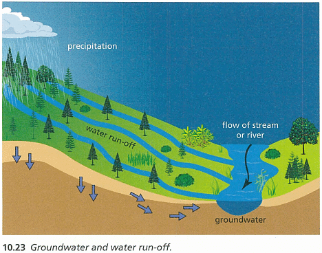
Ans: To demonstrate the water cycle in the diagram from figure 10.23, one would start with evaporation where water from oceans, lakes, or rivers turns into vapor and ascends into the atmosphere. This vapor then cools and condenses, forming clouds. Eventually, the water falls back to the ground as precipitation (rain or snow). This water can then either run off into bodies of water or seep into the ground as groundwater, continuing the cycle.
Q4. Look at figure 10.23. Use a map of the Earth to find the Sahara Desert. Explain why places like the Sahara Desert remain so dry.
Ans: The Sahara Desert remains dry largely due to its geographical location and prevailing weather patterns. It lies in a high-pressure zone where the air is descending, which inhibits cloud formation and results in minimal precipitation. This dry air increases temperatures and further prevents the formation of clouds, keeping the region arid.
Q5. Where does the energy come from that causes ice in glaciers and snow on mountains to melt?
Ans: The energy required to melt ice in glaciers and snow on mountains primarily comes from the sun. Solar radiation provides the heat necessary to increase the temperature of the ice and snow, causing it to melt.
Q6. Describe three ways in which water run-off can be formed.
Ans: Water run-off can be formed in several ways: (1) Rainfall that does not infiltrate into the soil can flow over the land surface, (2) melting snow and ice that flows over the land, and (3) water from irrigation or other human activities that does not get absorbed and instead flows over the land.
Q7. In very dry areas of land (such as in deserts) it is still possible for people to find water to drink, wash and cook with. People dig downwards into the ground to build a well. Explain where this water comes from.
Ans: In dry areas, the water found by digging wells comes from underground aquifers. These are layers of water-bearing rock or sand that collect water from surrounding higher ground. The water in aquifers typically originates from rain or melting snow that has seeped deep into the ground over many years.
End of the Chapter Review
Q1. A tectonic plate is:
a) a device for measuring the strength of earthquakes
b) a large area of the Earth's crust that 'floats' on the mantle
c) an area between two continents moving apart, where hot rock flows upwards
d) a layer of sedimentary rock that presses down on dead plants and animals to create fossiIs
Ans: b) a large area of the Earth’s crust that ‘floats’ on the mantle
Q2. Alfred Wegener's hypothesis was that:
a) huge waves are caused by earthquakes under an ocean
b) molten rock called magma flows upwards through the crust in volcanoes
c) the mixture of gases in the atmosphere changes over time
d) the continents are moving apart from a time when they were joined
together
Ans: d) the continents are moving apart from a time when they were joined together
Q3. In a scientific investigation, the part of the report that states whether or not and idea is proved by the evidence is called the:
a) hypothesis
b) method
c) analysis
d) conclusion
Ans: d) conclusion
Q4. Scientists comment on and evaluate other scientists' work. This process is called:
(a) a peer review
(b) b investigation
(c) c repeating measurements
(d) d writing a conclusion
Ans: a) peer review
Q5. The percentage of the atmosphere formed by nitrogen is:
a) 0.03%
b) 1%
c) 21%
d) 78%
Ans: c) 21%
Q6. (a) Describe two types of plate boundary where earthquakes can occur.
(b) Why do some earthquakes occur away from plate boundaries?
Ans:
(a) Types of Plate Boundaries Where Earthquakes Can Occur
Transform Boundaries:
- Description: Plates slide past each other horizontally.
- Earthquakes: Caused by frictional resistance between plates. Example: San Andreas Fault.
Convergent Boundaries (Subduction Zones):
- Description: One plate subducts beneath another.
- Earthquakes: Subduction generates friction and pressure, causing earthquakes. Example: Pacific Ring of Fire.
(b) Reasons:
Intraplate Earthquakes:
- Description: Occur within a tectonic plate.
- Causes: Residual stress, faults within plates, isostatic rebound, and induced seismicity.
Hotspots:
- Description: Areas of volcanic activity and mantle upwelling within plates.
- Earthquakes: Due to volcanic activity and stress from mantle plumes.
In summary, earthquakes can occur away from plate boundaries due to residual stress within plates, faults, isostatic rebound, induced seismicity, and volcanic activity associated with hotspots.
Q7.
(a) Make a drawing of a plate boundary showing how one plate can be pushed under another.
(b) Name the feature that is formed by the top plate as it moves upwards:
(c) Name a place in the world where this is occurring:
Ans(a):
Ans(b): Mountain range or volcanic arc
Ans(c): The Andes Mountains along the western edge of South America.
Q8. List four substances that pollute the atmosphere as a result of human activities:
Ans: Carbon dioxide, methane, nitrogen oxides, sulfur dioxide.
Q9. Describe how you could use a model to investigate glaciers melting to produce water run-off:
Ans: Use a physical or computer-generated model to simulate glacier dynamics under various climate scenarios to observe changes in meltwater production.
Q10. A student describes how tectonic plates only include continents of land that are moving. The student also concludes that because so few rift valleys are found on land, there are many fewer plate boundaries where plates are moving apart than where plates are moving together.
Write a response to this student, explaining:
(1) what tectonic plates they have forgotten to include,
(2) what is happening at these boundaries and
(3) naming at least two places in the world where there is evidence to support your response:
Ans:
(1) Oceanic plates, not just continental plates, are involved in tectonic movements.
(2) At these boundaries, plates can diverge, converge, or transform.
(3) The Mid-Atlantic Ridge (diverging) and the San Andreas Fault (transform) are two examples.
Q11. Copy and complete the table to describe the different effects that can happen at each type of plate boundary. Put Yes or No in each box: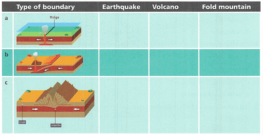

Ans:
Ridge: Earthquake (Yes), Volcano (No), Fold mountain (No);
Convergent: Earthquake (Yes), Volcano (Yes), Fold mountain (Yes);
Transform: Earthquake (Yes), Volcano (No), Fold mountain (No).
Q12.
(a) Give a historical example of an earthquake where the ground shaking has directly caused a large amount of damage to buildings and people:
(b) Explain how a tsunami is produced:
(c) Give an example of a tsunami that has caused a large amount of damage to buildings and people:
(d) Suggest two ways that people can be protected from the worst effects of earthquakes or tsunami:
Ans:
(a) The 2010 Haiti earthquake caused extensive damage and significant loss of life due to intense ground shaking.
(b) Tsunamis are usually generated by underwater earthquakes, which abruptly displace large volumes of water.
(c) The 2004 Indian Ocean tsunami, triggered by an undersea earthquake, caused massive destruction across several countries.
(d) Building earthquake-resistant infrastructure and establishing effective early warning systems.
Q13.
(a) What feature of tectonic plates would you expect to find under the Alps:
(b) The heights of these mountains have been studied and are not changing. What does this suggest about the tectonic plates that form the European continent?
Ans:
(a) Convergent boundary where the Eurasian and African plates meet.
(b) It suggests that the tectonic activity at this boundary has stabilized, and there is currently no significant uplift.
Q14.
(a) Explain what ‘groundwater’ is:
(b) One of these places is water run-off. Which one?
(c) Describe how the water in glaciers and ice caps can travel to become ocean water:
(d) Draw a chart of the water cycle on Earth. Include all six places where water is found from the table:
Ans:
(a) Groundwater is water that is held in the soil and in pervious rocks underground.
(b) Water in lakes and rivers.
(c) The water from melting glaciers and ice caps flows into rivers or directly into the oceans, contributing to sea level rise.
(d)
Q15.
(a) Describe how the Himalayas formed:
(b) In 2015, a large earthquake affected the country of Nepal. Suggest why this earthquake happened:
(c) The two plates are continuing to push against each other. Predict what you would expect to happen to the height of the Himalayas:
(d) Would you expect more earthquakes to occur in Nepal in future? Explain your answer:
Ans:
(a) The Himalayas formed from the collision and ongoing convergence of the Indo-Australian and Eurasian tectonic plates, pushing the land upward.
(b) It occurred due to the ongoing collision and tectonic pressure between the Indo-Australian and Eurasian plates at the convergent boundary.
(c) The height of the Himalayas is likely to continue increasing as the tectonic plates keep pushing against each other.
(d) Yes, as the tectonic activity continues at the convergent boundary, it is likely that more earthquakes will occur.
Q16.
(a) Give one natural process that forms carbon dioxide:
(b) Give two human activities that form carbon dioxide:
(c) Explain why it is very difficult to make accurate or reliable measurements of the amount of carbon dioxide in the air:
Ans:
(a) Respiration by animals and plants.
(b) Burning fossil fuels and deforestation.
(c) Due to its widespread sources, variable emissions rates, and the mixing properties of the atmosphere, measuring precise levels of CO2 consistently over time and space is challenging.
|
32 videos|61 docs|22 tests
|
FAQs on Textbook Solution: The Earth and Its Atmosphere - IGCSE Cambridge Science for Year 7 - Class 7
| 1. What are the three main components of the Earth's crust? |  |
| 2. How do earthquakes occur and what are their effects? |  |
| 3. What is the Earth's atmosphere made up of and what is its importance? |  |
| 4. Explain the water cycle and its significance for life on Earth. |  |
| 5. How are mountains formed and what role do they play in shaping the Earth's surface? |  |


