Ordnance Survey Maps Chapter Notes | IGCSE Oxford Geography Foundations for Year 6 - Class 6 PDF Download
Introduction
Ordnance Survey (OS) maps are detailed and accurate representations of specific areas, crucial for navigation and understanding landscapes. Students learn to read these maps, focusing on symbols, scales, and topographical features. This helps them develop spatial awareness and map-reading skills, essential for exploring physical and human geography.
How can we show direction?
Maps are helpful because they show us what things look like from above and where places are located. There are different types of maps such as street maps, road maps, atlas maps, and Ordnance Survey (OS) maps.
- A plan is a type of map that provides detailed information about small areas, showing places like schools, shopping centers, parks, and leisure centers.
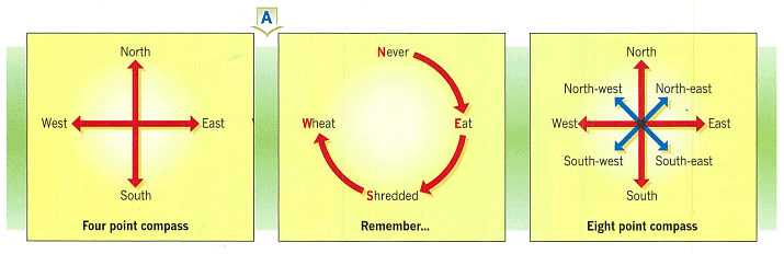
- This section is about direction. The best way to indicate direction is by using points of the compass. There are four main points: north, east, south, and west. You can remember their order with the phrase 'Never Eat Shredded Wheat'.
- Between these main points, there are four other points: north-east, south-east, south-west, and north-west. Most maps have a symbol to show the north direction. If there is no symbol, the top edge of the map should be considered north.Question for Chapter Notes: Ordnance Survey MapsTry yourself:How can we determine the north direction on a map?View Solution

How can we measure distance?
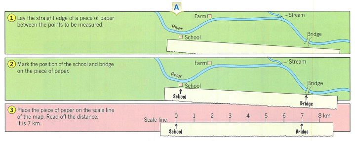
A map helps us find out how far one place is from another. Maps are drawn smaller than real life to fit on paper. The scale on a map shows how much smaller it is compared to real distances. For example, if 1 cm on the map equals 1 km in real life, the scale is 1:100,000.
- Every map should have a scale line. Straight line distances are easy to measure. Diagram A shows how to measure the shortest distance between the school and the bridge using the scale.
- The same method can be used for distances that are not straight lines. To measure these, divide the route into sections and measure each one. Diagram B shows how to measure the distance from the school to the bridge along the river, using a piece of paper to follow the bends.
What are grid references?
Maps can sometimes be complex, making it difficult to locate places. To make finding places easier, a grid of squares can be drawn on the map. Each square in the grid has its own unique reference number.
On Ordnance Survey maps, these grid lines are shown in blue and each has a special number. The grid lines form grid squares, and the numbers that give the position of a grid square are called grid references.
On these pages, you will learn about four-figure grid references.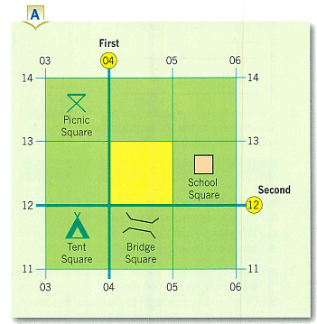
To give a four-figure grid reference:
- Look at the grid (Diagram A). Give the number of the line on the left of the yellow square (04).
- Give the number of the line at the bottom of the yellow square (12).
- Put these numbers together to get the grid reference: 0412.
Similarly, the Picnic Square has a reference of 0313 and the School Square is 0512.
What are the grid references for the Bridge Square and the Tent Square?
To find a grid reference: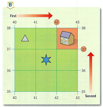
- Look at the grid (Diagram B). Go along the top until you come to 42.
- Go up the side until you come to 37.
- Follow these two lines until they meet. Your square will be above and to the right of that point.
- Squares 4136 and 4037 contain what?
[Intext Question]
How do we use six figure grid references?
Grid references are very useful for finding places on maps. A four-figure reference on an Ordnance Survey map covers an area of one square kilometer on the ground, which is quite large. For more accuracy, a six-figure grid reference is used, pinpointing a location within 100 meters.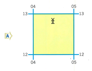
Look at the grid in Diagram A. The six-figure grid reference for the windmill is 045128. Here's how this reference is determined:
- Give the number of the line on the left of the yellow square (04).
- Divide the square into tenths. In Diagram B, follow arrow A across the square. The windmill is about halfway across from the left, so write down 5 after 04.
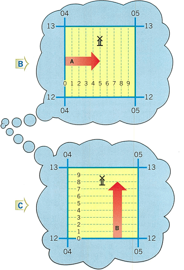
- Now you have the first half of your six-figure reference: 045.
- Give the number of the line at the bottom of the yellow square (12).
- Divide the square into tenths. In Diagram C, follow arrow B. The windmill is over halfway up from the bottom, so write down 8 after 12.
- Now you have the second half of your six-figure reference: 128.
- Put the two halves together and you have the six-figure grid reference: 045128.
 |
Download the notes
Chapter Notes: Ordnance Survey Maps
|
Download as PDF |
How is height shown on a map?
 |
Take a Practice Test
Test yourself on topics from Class 6 exam
|
Practice Now |
How do contours show height and relief?
Lines on a map that connect points of the same height are called contours. Contours indicate the height of the land and its shape, known as relief. Map makers choose the difference in height between contours, which is called the contour interval. On most Ordnance Survey maps, contours are drawn at intervals of 10 meters.
Contours are drawn by map makers and cannot be seen on the ground. In Diagram A, contours are shown on the main sketch, forming different patterns. An important thing to remember is that:
- The closer the contour lines are together, the steeper the slope.
|
13 videos|17 docs|5 tests
|


Summary
,mock tests for examination
,past year papers
,practice quizzes
,Ordnance Survey Maps Chapter Notes | IGCSE Oxford Geography Foundations for Year 6 - Class 6
,Ordnance Survey Maps Chapter Notes | IGCSE Oxford Geography Foundations for Year 6 - Class 6
,ppt
,Exam
,Previous Year Questions with Solutions
,MCQs
,Objective type Questions
,Extra Questions
,Viva Questions
,video lectures
,Ordnance Survey Maps Chapter Notes | IGCSE Oxford Geography Foundations for Year 6 - Class 6
,Sample Paper
,study material
,Semester Notes
,Important questions
,Free
,shortcuts and tricks
;


Chapter Notes: Ordnance Survey Maps Free PDF Download
Importance of Chapter Notes: Ordnance Survey Maps
Chapter Notes: Ordnance Survey Maps
Chapter Notes: Ordnance Survey Maps Class 6 Questions
Study Chapter Notes: Ordnance Survey Maps on the App
|
© EduRev
|
Education Revolution
|


|


