CBSE Sample Question Paper (2023-24) - 1 | Geography Class 11 - Humanities/Arts PDF Download
Time : 3 Hours
Maximum Marks : 80
General Instructions
- This question paper contains 30 questions. All questions are compulsory.
- This question paper is divided into five sections. Sections – A, B, C, D and E.
- Section A – Question number 1 to 17 are Multiple Choice Type Questions carrying 1 mark each.
- Section B – Question number 18 and 19 are Source Based Questions carrying 3 marks each.
- Section C – Question number 2D to 23 are Short Answer Type Questions carrying 3 marks each. Answer to these questions shall be written in 80 to 100 words.
- Section D – Question number 24 to 28 are Long Answer Type Questions carrying 5 marks each. Answer to these questions shall be written in 120 to 150 words.
- Section E – Question number 29 and 30 are Map based questions.
Section – A
Q1. There are two statements marked as Assertion (A) and Reason (R). Mark your answer as per the codes provided
below. 1
Assertion: The amount of insolation received by Earth on the 3rd of January is slightly less than the amount received on the 4th of July.
Reason: On 3rd January the distance between the sun and earth increases.
Options:
(A) Both (A) and (R) are true but (R) is not the correct explanation of (A)
(B) Both (A) and (R) are true and (R) is the correct explanation of (A)
(C) Both (A) and (R) are incorrect.
(D) (A) is correct but (R) is incorrect.
Ans: Option (C) is correct.
The amount of insolation received by earth on 3rd January is slightly more than the amount received on 4th July as on 3rd January the distance decreases between the sun and the earth.
Q2. Consider the following and choose the correct answer with the help of given codes: 1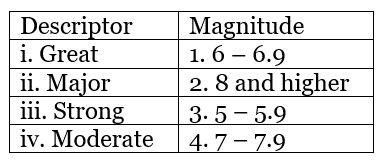
Options: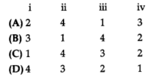 Ans:Option (A) is correct.
Explanation:
- Great (Magnitude 8+): Extremely powerful, causing widespread destruction and tsunamis. Catastrophic impacts, rare.
- Major (Magnitude 7 – 7.9): Very powerful, significant damage to structures, casualties, and disruptions.
- Strong (Magnitude 6 – 6.9): Capable of damaging buildings, felt over large areas, potential risks.
- Moderate (Magnitude 5 – 5.9): Felt widely, minimal damage, slight to moderate shaking.
Q3. The Big Bang Theory is also called the: 1
(A) Galaxy Theory
(B) Expanding Universe Hypothesis
(C) Nebular Hypothesis
(D) Galaxy Expansion Theory
Ans:
Option (B) is correct.
The Big Bang Theory, also called as the expanding universe hypothesis, was supported by Edwin Hubble’s 1920 evidence showing galaxies moving away over time. An analogy often used is inflating a balloon with marked points, illustrating how space between galaxies increases.
Q4. Consider the following statements and choose the correct answer with the help of the given options: 1
I. The amount of heat received by different parts of the earth is not the same.
II. This leads to the transfer of heat from one region to another by winds.
(A) Both statements are true
(B) Only statement I is true
(C) Only statement II is true
(D) Both statements are wrong
Ans:
Option (A) is correct.
The variation in heat causes pressure differences in atmosphere and leads to heat transfer.
Q5. Given below is a list of layers of the Atmosphere and its Height in km. Which of the following pair is NOT correctly matched? 1
Ans:
Option (B) is correct.
The stratosphere extends to a height of 50 km.
Q6. The Solid mineral material forming part of the surface of the earth is called: 1
(A) rock
(B) magma
(C) sand
(D) silt
Ans:
Option (A) is correct.
Solid mineral material that constitutes the Earth’s surface is referred to as ‘rock.’ Rocks are composed of various mineral and organic substances, forming the fundamental building blocks of the Earth’s crust.
Q7. Which of the following are the physical characteristics of ocean water? 1
(A) Temperature
(B) Salinity
(C) Density
(D) All of these
Ans:
Option (D) is correct.
Dynamic ocean water has physical characteristics like temperature, salinity and density that influence its movement.
Q8. The length of the international border between India and Pakistan is: 1
(A) 3310 Km
(B) 2210 Km
(C) 1110 Km
(D) 1010 Km
Ans:
Option (A) is correct.
The international border between India and Pakistan stretches approximately 3310 kilometres, creating a significant boundary between the two neighbouring countries.
Q9. The southernmost part of India is: 1
(A) Sonia Point
(B) Indira Point
(C) Nehru Point
(D) Gandhi Point
Ans:
Option (B) is correct.
The southernmost part of India is called Indira Point, extending into the Indian Ocean.
Q10. Consider the following statements and choose the correct answer with the help of given options: 1
Statement I: Areas in the interior of India are under the moderating influence of the sea.
Statement II: Delhi, Kanpur, Amritsar experience seasonal contrasts in weather.
(A) Only statement I is correct
(B) Only statement II is correct
(C) Both the statements are correct, and statement II correctly explains statement I.
(D) Both the statements are true but not related with each other.
Ans:
Option (B) is correct.
Statement i is incorrect as areas in the interior of India are far away from the moderating influence of the sea and experience extreme climate.
Q11. Arrange the stages of planet formation in the correct order: 1
(i) The condensation of the gas cloud and formation of chondrules
(ii) More violent and rapid impact accretion
(iii) The accretion of gas and dust to form small bodies between 1-10 km in diameter
(iv) The gravitational collapse of a star
(A) i, ii, iv, iii
(B) iv, i, iii, ii
(C) iii, iv, ii, i
(D) iii, i, ii, iv
Ans:
Option (B) is correct.
Explanation:
(iv) The gravitational collapse of a star leads to the formation of a core and a rotating disk of gas and dust around the core.
(i) The condensation of the gas cloud and formation of chondrules happen within the gas and dust disk around the core.
(iii) Accretion of gas and dust leads to the formation of small planetesimals (small-rounded objects) which then develop cohesion.
(ii) More violent and rapid impact accretion occurs as smaller planetesimals collide to form larger bodies.
Q12. Name the river which in Tibet is known as Langchen Khambab: 1
(A) Ravi
(B) Teesta
(C) Satluj
(D) Beas
Ans:
Option (C) is correct.
The river Satluj, which flows through India, is known as Langchen Khambab in Tibet.
Q13. They are formed by the alluvial deposits brought by the rivers-the Indus, the Ganges and the Brahmaputra: 1
(A) Brahmaputra Plains
(B) The Northern Plains
(C) Nimbus
(D) Cumulus
Ans: Option (B) is correct.
The fertile Northern Plains in India are formed by the alluvial deposits carried by the Indus, Ganges, and Brahmaputra rivers, making the land rich for farming.
Q14. The ……………………… are young, weak and flexible in their geological structure unlike the rigid and stable Peninsular
Block. 1
(A) Karakoram
(B) Himalayas
(C) Anamudi
(D) Khasi
Ans: Option (B) is correct.
Unlike the stable Peninsular Block, the young and flexible geological structure of the Himalayas makes them prone to geological changes.
Read the following graph and answer question no 15 to 17.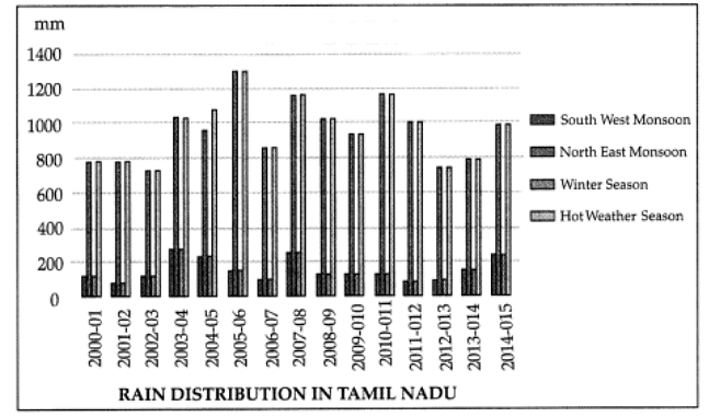 Q15.The rainfall in the given graph is measured in:
(A) Centimetres
(B) Millimetres
(C) Kilometres
(D) None of these
Ans:
Option (B) is correct.
Rainfall usually is measured in centimetres and millimetres and in the given graph it is measured in millimetres.
Q16. Which year received the maximum rain from North East Monsoon?
(A) 2003 – 04
(B) 2005 – 06
(C) 2007 – 08
(D) 2010 – 11
Ans:
Option (B) is correct.
North-east Monsoon is the major period of rainfall activity over south peninsula which was maximum during this period.
Q17. Which year received 800 mm of rainfall from both Southwest and Northeast Monsoons?
(A) 2000 – 01
(B) 2001 – 02
(C) 2012 – 13
(D) 2013 – 14
Ans:
Option (B) is correct.
This period received rainfall both during summer and winter.
Section – B
Question 18 & 19 are Source Based Questions.
Q18. Read the given Passage carefully and answer the questions that follow: 3
The causes for climate change are many. They can be grouped into astronomical and terrestrial causes. The astronomical causes are the changes in solar output associated with sunspot activities. Sunspots are dark and cooler patches on the sun which increase and decrease in a cyclical manner. According to some meteorologists, when the number of sunspots increase, cooler and wetter weather and greater storminess occur.
A decrease in sunspot numbers is associated with warm and drier conditions. Yet, these findings are not statistically
significant. Another astronomical theory is Milankovitch oscillations, which infer cycles in the variations in the
earth’s orbital characteristics around the sun, the wobbling of the earth and the changes in the earth’s axial tilt. All these alter the amount of insolation received from the sun, which in turn, might have a bearing on the climate. Volcanism is considered as another cause for climate change. Volcanic eruption throws up lots of aerosols into ? the atmosphere. These aerosols remain in the atmosphere for a considerable period of time reducing the sun’s radiation reaching the Earth’s surface. After the recent Pinatubo and El Cion volcanic eruptions, the average temperature of the earth fell to some extent for some years. The most important anthropogenic effect on the climate is the increasing trend in the concentration of greenhouse gases in the atmosphere which is likely to cause global warming.
a. What is dark and cooler patches on the sun which increases and decreases in a cyclical manner called?
b. What kind of material is thrown up a lot into the atmosphere during a volcanic eruption?
c. What is the most important anthropogenic effect on the climates?
Ans:
a. Sunspots
b. Aerosols
c. Increasing trend in the concentration greenhouse gases in the atmosphere.
Q19. Observe the given map and answer the following questions: 3
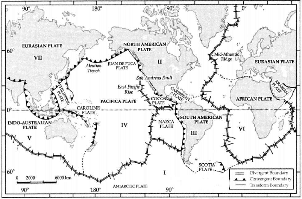 a. Name the tectonic plate that is between the Asiatic and Pacific plate.b. Name the tectonic plate between the Central American and Pacific plates.
c. Name the tectonic plate between South America and the Pacific plate.
Ans:
a. Philippine Plate
b. Cocos Plate
c. Nazca Plate
Section – C
Question numbers 20 to 23 are Short Answer Type Questions.
Q20. How do geographers play an important role in any country? 3
OR
Why is geography considered an important subject? 3
Ans: Important role of the geographers for any country:
(i) Geographers study the various similar and dissimilar features of the Earth’s surface and its cause-and-effect relationship with the population of that particular country. For example, a geographer will study the reasons as to why the cropping pattern differs from state to state in a country. This difference in the cropping pattern is due to the difference in climate, soil, demand, transport facilities, rainfall, etc.
(ii) A geographer helps predict the climate and the cause-effect relationship of the same. He also helps in predicting the natural calamities that might hit the country in the nearing future.
(iii) As a geographer, he studies the relation-ship between humans and nature which is highly dynamic.
OR
Geography is considered as an important subject because:
- We live on Earth, therefore, it is very important for us to understand the mechanism of our planet. It gives us a visual sense of the Earth’s surface.
- We are heavily dependent on the natural resources available on the Earth’s surface. In order to know how efficiently it can be used, it is important to study geography.
- Climate is a major deciding factor in the type of crops to be grown, human settle-ments, food to be eaten, shelter to be built, etc. To understand the interrelationship between the climate and human movements, it is important to study geography as a subject.
Q21. Write three points of difference between body waves and surface waves. 3
Ans: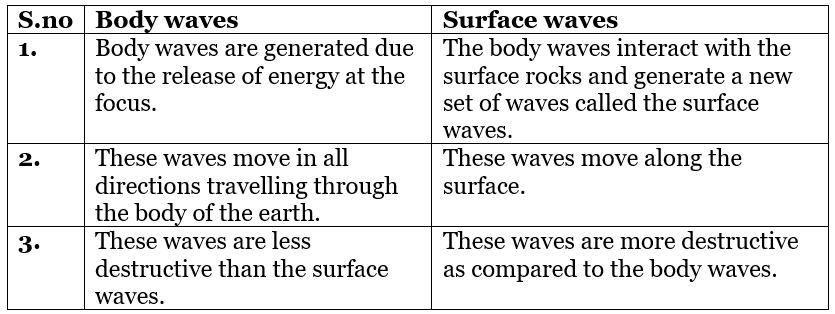
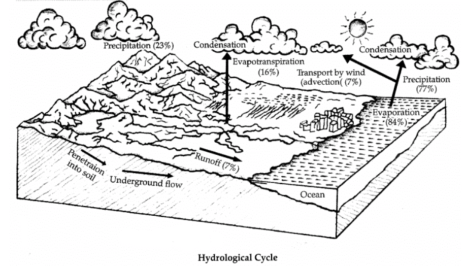
Q22. ‘Water is a cyclic resource’. Explain. 3
OR
Explain the process of hydrological cycle.
Ans: Water is a cyclic resource. It can be used and re-used. Water also undergoes a cycle from the ocean to land and land to ocean. The hydrological cycle describes the movement of water on, in, and above the earth. The water cycle has been working for billions of years and all the life on earth depends on it.
OR
The hydrological cycle, is the circulation of water within the earth’s hydrosphere in different forms i.e., the liquid, solid and gaseous phases. It also refers to the continuous exchange of water between the oceans atmosphere, land surface and subsurface and organisms. About 71 per cent of the planetary water is found in the oceans. The remaining is held as freshwater in glaciers and ice caps, groundwater sources, lakes, soil moisture, atmosphere, streams and within life. Nearly 59 per cent of the water that falls on land returns to the atmosphere through evaporation from over the oceans as well as from other places. The remainder runs off on the surface, infiltrates into the ground or a part of it becomes a glacier.
Q23. Why is there a time variation of 2 hours between the easternmost and westernmost part of the country? 3
Ans: The time variation of 2 hours is due to the fact that the Sun rises two hours earlier in Arunachal Pradesh as compared to Gujarat. This is because the earth is tilted and also it rotates in the East to West direction.
So, during rotation, the eastern parts of the world experience the sun’s rays earlier as compared to the western parts of the world.
Section – D
Question numbers 24 to 28 are Long Answer Type Questions.
Q24. Differentiate between physical weathering and chemical weathering. 5
Ans: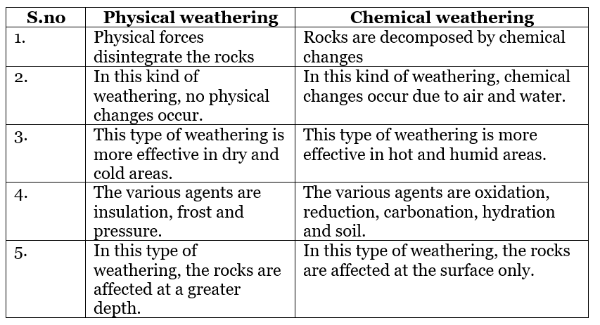
Q25. Explain the structure of the atmosphere with the help of a labelled diagram. 5
Ans: The atmosphere is divided into five different layers depending upon the temperature condition.
(i) Troposphere: The troposphere is the lowermost layer of the atmosphere. Its average height is 13 km and extends roughly to a height of 8 km near the poles and about 18 km at the equator. The thickness of the troposphere is greatest at the equator because heat is transported to great heights by strong convectional currents. This layer contains dust particles and water vapour. All changes in climate and weather take place in this layer. The temperature in this layer decreases at the rate of 1°C for every 165 m of height. This is the most important layer for all biological activity.
(ii) Stratosphere: The stratosphere is found above the tropopause and extends up to a height of 50 km. It contains the ozone layer and absorbs ultraviolet radiation and shields life on the earth from intense, harmful forms of energy.
(iii) Mesosphere: The mesosphere lies above the stratosphere, which extends up to a height of 80 km. In this layer, once again, the temperature starts decreasing with the increase in altitude and reaches up to minus 100°C at the height of 80 km.
(iv) Ionosphere: The ionosphere is located between 80 and 400 km above the mesopause. It contains electrically charged particles known as ions, and hence, it is known as the ionosphere. Radio waves transmitted from the earth are reflected back to the earth by this layer. The temperature here starts increasing with height.
(v) Exosphere: The uppermost layer of the atmosphere above the ionosphere is known as the exosphere. This is the highest layer but very little is known about it. Whatever contents are there, these are extremely rarefied in this layer, and it gradually merges with outer space.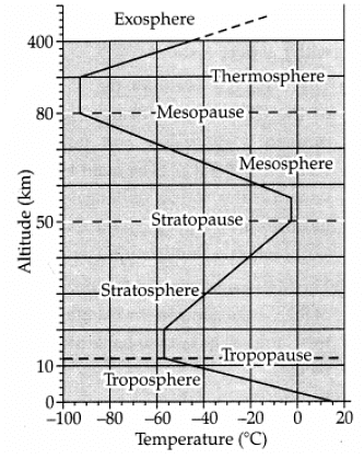
Q26. Difference between the Western Ghats and the Eastern Ghats. 5
OR
Write a detailed note on the Northern Plains.
Ans: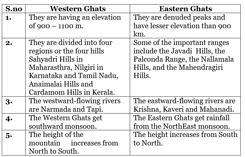
OR
The Northern Plains are formed by the alluvial deposits brought by the rivers – the Indus, the Ganga and the Brahmaputra. These plains extend approximately 3,200 km from the East to the West. The average width of these plains varies between 150 – 300 km. The maximum depth of alluvium deposits varies between 1,000 – 2,000 m. From the North to the South, these can be divided into three major zones: the Bhabar, the Tarai and the alluvial plains.
Bhabar: Bhabar is a narrow belt ranging between 8 – 10 km parallel to the Shiwalik foothills at the break-up of the slope. As a result of this, the streams and rivers coming from the mountains deposit heavy materials of rocks and boulders, and at times, disappear in this zone.
Tarai: Its approximate width is 20 – 30 km where most of the streams and rivers re-emerge without having any properly demarcated channel, thereby, creating marshy and swampy conditions known as the Tarai. It has a luxurious growth of natural vegetation and houses varied wildlife.
Alluvial Plains: These plains have characteristic features of the mature stage of fluvial erosional and depositional landforms such as sand bars, meanders, oxbow lakes and braided channels. The Brahmaputra plains are known for their riverine islands and sand bars. Most of these areas are subjected to periodic floods and shifting river courses forming braided streams. The mouths of these mighty rivers also form some of the largest deltas of the world, for example, the famous Sunderbans Delta.
This is a featureless plain with a general elevation of 50 – 150 m above the mean sea level. The states of Haryana and Delhi form a water divide between the Indus and the Ganga River Systems. As opposed to this, the Brahmaputra River flows from the northeast to the southwest direction before it takes an almost 90° southward turn at Dhubri before it enters Bangladesh.
Q27. Write a note on the tributaries of the Indus River System. 5
OR
Write a note on the important tributaries of the Ganga System.
Ans: The tributaries of Indus:
(i) The Jhelum, rises from a spring at Verinag situated at the foot of the Pir Panjal in the south-eastern part of the valley of Kashmir. It flows through Srinagar and the Wular lake before entering Pakistan through a deep narrow gorge. It joins the Chenab near Jhang in Pakistan.
(ii) The Chenab is the largest tributary of the Indus. It is formed by two streams, the Chandra and the Bhaga, which join at Tandi near Keylong in Himachal Pradesh. Hence, it is also known as Chandrabhaga. The river flows for 1,180 km before entering into Pakistan.
(iii) The Ravi rises west of the Rohtang pass in the Kullu hills of Himachal Pradesh and flows through the Chamba valley of the state. Before entering Pakistan and joining the Chenab near Sarai Sidhu, it drains the area lying between the south-eastern part of the Pir Panjal and the Dhauladhar ranges.
(iv) The Beas originates from the Beas Kund near the Rohtang Pass at an elevation of 4,000 m above the mean sea level. The river flows through the Kullu valley and forms gorges at Kati and Largi in the Dhaoladhar range. It enters the Punjab plains where it meets the Satluj near Harike. The Satluj originates in the Rakas lake near Mansarovar at an altitude of 4,555 m in Tibet where it is known as Langchen Khambab. It flows almost parallel to the Indus for about 400 km before entering India and comes out of a gorge at Rupar. It passes through the Shipki La on the Himalayan ranges and enters the Punjab plains.
OR
The Ganga is the most important river of India. both from the point of view of its basin and cultural significance. Important tributaries of the Ganga System are:
(i) The Yamuna, the western most and the longest tributary of the Ganga, has its source in the Yamunotri glacier on the western slopes of Banderpunch range (6,316 km). It joins the Ganga at Prayag (Allahabad). Much of its water feeds the western and eastern Yamuna and the Agra canals for irrigation purposes.
(ii) The Chambal rises near Mhow in the Malwa plateau of Madhya Pradesh and flows northwards through a gorge upwards of Kota in Rajasthan, where the Gandhisagar dam has been constructed. From Kota, it traverses down to Bundi, Sawai Madhopur and Dholpur, and finally joins the Yamuna.(iii) The Gandak comprises two streams, namely Kaligandak and Trishulganga. It rises in the Nepal Himalayas
between the Dhaulagiri and Mount Everest and drains the central part of Nepal. It enters the Ganga plain in Champaran district of Bihar and joins the Ganga at Sonpur near Patna.
(iv) The Ghaghara originates in the glaciers of Mapchachungo. After collecting the waters of its tributaries – Tila, Seti and Beri, it comes out of the mountain, cutting a deep gorge at Shishapani. The river Sarda (Kali or Kali Ganga) joins it in the plain before it finally meets the Ganga at Chhapra.
(v) The Kosi is an antecedent river with its source to the north of Mount Everest in Tibet, where its main stream Arun rises. After crossing the Central Himalayas in Nepal, it is joined by the Son Kosi from the West and the Tamur Kosi from the East. It forms Sapt Kosi after uniting with the river Arun.(vi) The Damodar occupies the eastern margins of the Chotanagpur Plateau where it flows through a rift valley and finally
joins the Hugli. The Barakar is its main tributary. Once known as the ‘sorrow of Bengal’, the Damodar has been now tamed by the Damodar Valley Corporation, a multipurpose project.
(vii) The Mahanandi is another important tributary of the Ganga rising in the Darjiling hills. It joins the Ganga as its last left bank tributary in West Bengal.
(viii) The Son is a large south-bank tributary of the Ganga, originating in the Amarkantak plateau. After forming a series of waterfalls at the edge of the plateau, it reaches Arrah, west of Patna, to join the Ganga.
Q28. Explain any five factors that determine the climate of India based on location and relief. e|U 5
OR
Explain the three categories of social forestry.
Ans: Factors affecting climate related to Location and Relief:
(i) Latitude: The Tropic of Cancer passes through the central part of India in an East-West direction. Thus, the northern part of India lies in sub-tropical and temperate zone and the part lying south of the Tropic of Cancer falls in the tropical zone. The tropical zone being nearer to the equator, experiences high temperatures throughout the year with small daily and annual range. Area north of the Tropic of Cancer being away from the Equator, experiences extreme climate with high daily and annual range of temperature.
(ii) The Himalayan Mountains: The lofty Himalayas in the north along with its extensions act as an effective climatic divide. The towering mountain chain provides an invincible shield to protect the subcontinent from the cold northern winds. The Himalayas also trap the monsoon winds, forcing them to shed their moisture within the subcontinent.
(iii) Distribution of Land and Water: India is flanked by the Indian Ocean on three sides in the south and girdled by a high and continuous mountain-wall in the north. As compared to the landmass, water heats up or cools down slowly. This differential heating of land and sea creates different air pressure zones in different seasons in and around the Indian subcontinent.
(iv) Distance from the Sea: With a long coastline, large coastal areas have an equable climate. Areas in the interior of India are far away from the moderating influence of the sea. Such areas have extremes of climate.
(v) Altitude: Temperature decreases with height. Due to thin air, places in the mountains are cooler than places on the plains.
(vi) Relief: The physiography or relief of India also affects the temperature, air pressure, direction and speed of wind and the amount and distribution of rainfall. The windward sides of Western Ghats and Assam receive high rainfall during June-September whereas the southern plateau remains dry due to its leeward situation along the Western ghats.
OR
Social forestry can be classified into:
(i) Urban forestry: It pertains to the raising and management of trees on public and privately owned lands in and around urban centres such as green belts, parks, roadside avenues, industrial and commercial green belts, etc.
(ii) Rural forestry lays emphasis on the promotion of agro-forestry and community forestry.
(a) Agro-forestry: It is the raising of trees and agricultural crops on the same land inclusive of the waste patches. It combines forestry with agriculture, thus, altering the simultaneous production of food, fodder, fuel, timber and fruit.
(b) Community forestry: It involves the raising of trees on public community lands such as the village pasture and temple land, roadside, canal bank, strips along railway lines, schools, etc. Community forestry programme aims at providing benefits to the community as a whole. Community forestry provides a means under which the people of landless classes can associate themselves with tree raising and thus, get those benefits that otherwise are restricted for landowners.
(iii) Farm forestry: It is a term applied to the process under which farmers grow trees for commercial and non-commercial purposes on their farmlands. Forest departments of various states distribute seedlings of trees free of cost to small and medium farmers. Several lands such as the margins of agricultural fields, grasslands and pastures, land around homes and cow sheds may be used for raising trees under non-commercial farm forestry.
Section – E
Question numbers 29 & 30 are Map based questions having 5 sub-parts each.
Q29. Identify the places based on the given information and label them on the India Map. Identify any five of the following: 5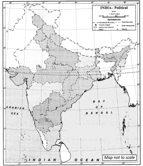 (A) Flood prone area of Gujarat ‘(B) Drought prone area on the west
(C) Earthquake prone area in the northern India
(D) Landslide prone area of south .
(E) Most cyclone prone area of India
(F) Northernmost state of India
(G) Any one very high risk zone (Earthquake) area
Ans: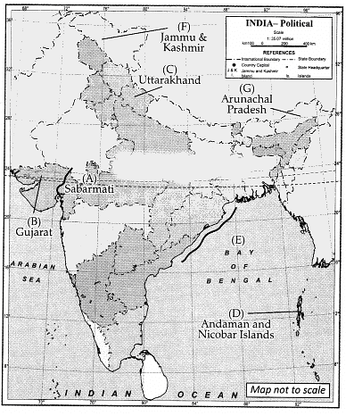 (A) Sabarmati(B) Gujarat
(C) Uttarakhand
(D) Andaman & Nicobar Islands
(E) Bay of Bengal
(F) Jammu and Kashmir
(G) Arunachal Pradesh (Any Five)
Q30. On the outline map of the world, locate and label any five of the following. 5
(A) Tropical Andes
(B) Atlantic Forest
(C) Eastern Madagascar
(D) Western Ghats
(E) Central American Highlands Forests
(F) Himalayas (Any five)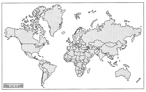 Ans:
Ans: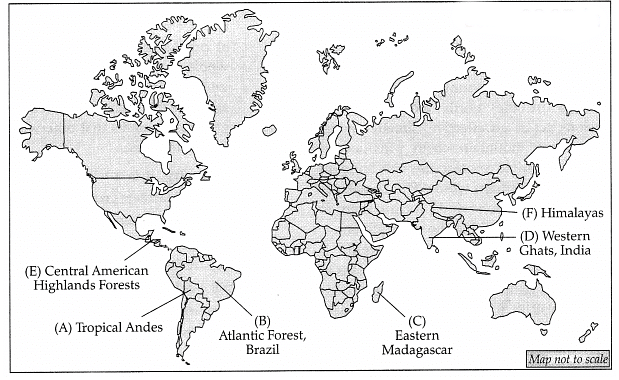
|
70 videos|289 docs|44 tests
|
FAQs on CBSE Sample Question Paper (2023-24) - 1 - Geography Class 11 - Humanities/Arts
| 1. What are the career options available after studying Humanities/Arts? |  |
| 2. How can studying Humanities/Arts help in developing critical thinking skills? |  |
| 3. Is it necessary to pursue a specific specialization within Humanities/Arts for a successful career? |  |
| 4. How can one make the most of studying Humanities/Arts in terms of personal growth and development? |  |
| 5. What are the benefits of pursuing a degree in Humanities/Arts in today's competitive job market? |  |


