CBSE Sample Question Paper (2022-23) - 1 | Geography Class 11 - Humanities/Arts PDF Download
Time Allowed: 2 Hours
Maximum Marks: 80
General Instructions:
- All questions are compulsory.
- Question number 1 to 14 are Multiple choice questions carrying 1 mark each.
- Question number 15 to 16 are Multiple source based questions carrying 3 marks each.
- Question number 17 to 21 are Short-answer questions carrying 3 marks each. Answer to each of these questions should not exceed 80 – 100 words.
- Question number 22 to 26 are Long-answer questions carrying 5 marks each. Answer to each of these questions should not exceed 150 words.
- Question number 27 and 28 are related to identification or locating and labelling of geographical features on maps, carrying 5 marks each.
Q1. Geography should be studied as an: [1]
(a) integrated subject
(b) independent subject
(c) intermingled subject
(d) interlocked subject
Ans: (b) independent subject
Q2. The expansion of the universe means increase in space between the: [1]
(a) universe
(b) gases
(c) galaxies
(d) bodies
Ans: (c) galaxies
Q3. The earth’s radius is: [1]
(a) 6,370 km
(b) 7,370 km
(c) 8,370 km
(d) 9,370 km
Ans: (a) 6,370 km
Q4. Which one of the following describes the lithosphere: [1]
(a) upper and lower mantle
(b) crust and upper mantle
(c) crust and core
(d) mantle and core
Ans: (b) crust and upper mantle
Q5. Which one of the following is not a minor plate: [1]
(a) Nazca
(b) Arabia
(c) Philippines
(d) Antarctica
Ans: (d) Antarctica
Q6. The plain formed as a result of stream erosion is called: [1]
(a) paired terraces
(b) meanders
(c) peneplain
(d) canyon
Ans:(c) peneplain
Q7. A deep valley characterised by steep step-like side slopes is known as: [1]
(a) U-shaped valley
(b) Gorge
(c) Blind valley
(d) Canyon
Ans: (d) Canyon
Q8. Which one of the following gases constitutes the major portion of the atmosphere: [1]
(a) Oxygen
(b) Nitrogen
(c) Argon
(d) Carbon dioxide
Ans: (b) Nitrogen
Q9. In which one of the following cities, are the days the longest: [1]
(a) Thiruvananthapuram
(b) Chandigarh
(c) Hyderabad
(d) Nagpur
Ans: (a) Thiruvananthapuram
Q10. Tornadoes generally occur in: [1]
(a) upper latitudes
(b) down latitudes
(c) middle latitudes
(d) intermediate latitudes
Ans: (c) middle latitudes
Q11. Arrange the course of River Ganga in the correct order: [1]
(i) Rises at the terminus of the Gangotri Glacier
(ii) Forms clear water of Bhagirathi River
(iii) Flows down the Himalayas
(iv) Joins the Alaknanda River
Options:
(a) iv, iii, ii, i
(b) iii, ii, i, iv
(c) i, ii, iii, iv
(d) ii, iii, i, iv
Ans: (c) i, ii, iii, iv
Q12. Arrange the cloud formation process in correct order: [1]
(i) Water travels into the sky within air as water vapour.
(ii) During day time water from different sources like pond, lake, river, sea, well, etc. get evaporated.
(iii) At a particular height the air cools.
(iv) The water vapour condenses to form minute droplets.
Options:
(a) i, ii, iii, iv
(b) iv, ii, i, iii
(c) ii, i, iii, iv
(d) iv, i, ii, iii
Ans: (c) ii, i, iii, iv
Q13. Which one of the following is the highest cloud in the sky: [1]
(a) Cirrus
(b) Stratus
(c) Nimbus
(d) Cumulus
Ans: (a) Cirrus
Q14. The english capital letters such as A, B, C, D and E present the: [1]
(a) Perennial climate groups
(b) Koeppen climate groups
(c) Ratzel climate groups
(d) Mackinder climate groups
Ans: (b) Koeppen climate groups
Q15. Read the case study given below and answer any three of the questions that follow.
While the world is divided into 24 time zones, there has to be a place where there is a difference in days, somewhere the day truly “starts” on the planet. The 180° line of longitude is approximately where the International Date Line passes. The time at this longitude is exactly 12 hours from the 0° longitude, irrespective of one travel westward or eastward from the Prime Meridian.
We know that time increases east of the Prime Meridian and decreases to its west. Hence, for a person moving east of the Prime Meridian, the time would be 12 hours less than the time at 0° longitude. For another person moving westward, the time would be 12 hours more than the Prime Meridian. For example, a person moving eastward on Tuesday will count the day as Wednesday once the International Date Line is crossed. Similarly, another person starting his journey on the same day, but moving westward will count the day as Monday after crossing the line.
(i) The world is divided into how many time zones? [1]
(a) 24
(b) 23
(c) 22
(d) 21
Ans: (a) 24
(ii) What is the time at 180° line of longitude? [1]
(a) 14 hours from the 0° longitude
(b) 12 hours from the 0° longitude
(c) 16 hours from the 0° longitude
(d) 18 hours from the 0° longitude
Ans:
(b) 12 hours from the 0° longitude
(iii) The time increases _______ of the Prime Meridian. [1]
(a) north
(b) south
(c) east
(d) west
Ans: (c) east
Q16. Read the case study given below and answer any three of the questions that follow.
The oceans are confined to the great depressions of the earth’s outer layer. The oceans, unlike the continents, merge so naturally into one another that it is hard to demarcate them. The geographers have divided the oceanic part of the earth into five oceans, namely the Pacific, the Atlantic, the Indian Southern Ocean and the Arctic. The various seas, bays, gulfs and other inlets are parts of these four large oceans.
A major portion of the ocean floor is found between 3-6 km below the sea level. The ‘land’ under the waters of the oceans, that is, the ocean floor exhibits complex and varied features as those observed over the land. The floors of the oceans are rugged With the world’s largest mountain ranges, deepest trenches and the largest plains. These features are formed, like those of the continents, by the factors of tectonic, volcanic and depositional processes.
(i) The oceans are confined to which of the Earth’s layer? [1]
(a) Outer layer
(b) Inner layer
(c) Core layer
(d) None of the above
Ans: (a) Outer layer
(ii) Oceans are hard to _______. [1]
(a) demarcate
(b) adjust
(c) accommodate
(d) find
Ans: (a) demarcate
(iii) Where is the major portion of the ocean floor found? [1]
(a) 2-4 km below tire sea level
(b) 3-6 km below the sea level
(c) 6-8 km below the sea level
(d) 8-10km below the sea level
Ans: (b) 3-6 km below the sea level
Q17. Name the various hypotheses associated with the formation of the Earth. [3]
Ans: The various hypotheses associated with the formation of the Earth are:
- Nebular Hypothesis: It was given by Laplace. The hypothesis considered that the planets were formed out of a cloud of material associated with a youthful sun, which was slowly rotating.
- Collision Hypothesis: It was given by Sir James and Harold Jeffrey. This theory suggests that the moon was formed out of the debris left over from a collision between the Earth and an astronomical body up to the size of Mars, approximately 4.5 billion years ago.
- Accretion Hypothesis: It was given by Schmidt and Carl Weizarscar. This hypothesis argues that about 4.6 million years ago our solar system formed from a cloud of gas and dust which slowly contracted under mutual gravity of all its particles.
- The Big Bang Theory: It was given by Edwin Hubble. He argued that the universe was ever expanding. As time passes, galaxies move further and further apart.
Q18. What do you know about the presence of gases, water vapour and dust particles present in the atmosphere? [3]
Ans:
- Gases: The volume of other gases is constant but the volume of carbon dioxide has been rising in the past few decades mainly because of the burning of fossil fuels. This has also increased the temperature of the air.
- Water vapour: Water vapour is also a variable gas in the atmosphere, which decreases with altitude. It also absorbs parts of the insolation from the sun and preserves the Earth’s radiated heat. It acts like a blanket allowing the Earth neither to become too cold nor too hot. Water vapour also contributes to the stability and instability in the air.
- Dust particles: Dust particles are generally concentrated in the lower layers of the atmosphere; yet, convection air currents may transport them to great heights. Dust and salt particles act as hygroscopic nuclei around which water vapour condenses to produce clouds.
Q19. ‘Water is a cyclic resource.’ Explain. [3]
Ans: Water is a cyclic resource. It can be used and re-used. Water also undergoes a cycle from the ocean to land and land to ocean. The hydrological cycle describes the movement of water on, in, and above the Earth. The water cycle has been working for billions of years and all the life on Earth depends on it.
Q20. xplain with examples the regional variations in temperature, winds and rainfall. [3]
Ans:
- While in the summer the mercury occasionally touches 55°C in the Western Rajasthan, it drops down to as low as minus 45°C in winter around Leh. Churu in Rajasthan may record a temperature of 50°C or more on a June day, while the mercury hardly touches 19°C in Tawang (Arunachal Pradesh) on the same day.
- On a December night, the temperature in Drass (Jammu and Kashmir) may drop down to minus 45°C, while Thiruvananthapuram or Chennai on the same night records 20°C or 22°C. These examples confirm that there are seasonal variations in temperature from place to place and from region to region in India. While snowfall occurs in the Himalayas, it only rains over the rest of the country.
- Similarly, variations are noticeable not only in the type of precipitation but also in its amount. While Cherrapunji and Mawsynram in the Khasi Hills of Meghalaya receive rainfall over 1,080 cm in a year, Jaisalmer in Rajasthan rarely gets more than 9 cm of rainfall during the same period.
- The Ganga delta and the coastal plains of Odisha are hit by strong rain-bearing storms almost every third or fifth day in July and August, while the Coromandel Coast, a thousand km to the South, goes generally dry during these months. Most parts of the country get rainfall during June-September, but on the coastal areas of Tamil Nadu, it rains at the beginning of the winter season.
Q21. Differentiate between man-made disasters and natural disasters. [3]
Ans: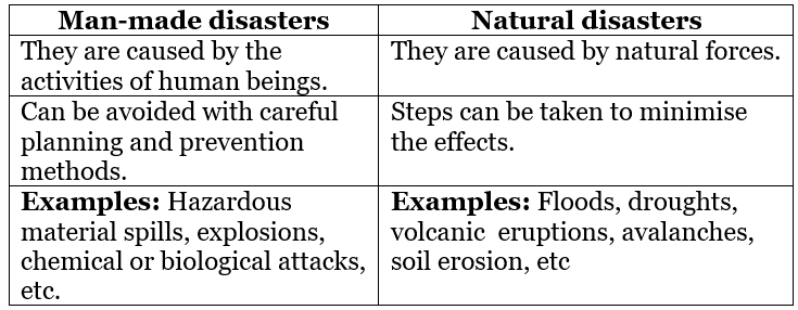
Q22. Explain the working and structure of an ecosystem. [5]
Ans:
The structure of an ecosystem involves a description of the available plant and animal species. From a structural point of view, all ecosystems consist of abiotic and biotic factors.
- Abiotic factors include rainfall, temperature, sunlight, atmospheric humidity, soil conditions, inorganic substances (carbon dioxide, water, nitrogen, calcium, phosphorus, potassium, etc.).
- Biotic factors include the producers (primary, secondary, tertiary), the consumers and the decomposers. The producers include all the green plants, which manufacture their own food through photosynthesis.
- The primary consumers include herbivorous animals like deer, goats, mice, and all plant-eating animals. The carnivores include all the flesh-eating animals like snakes, tigers, and lions.
- Certain carnivores thal feed also on carnivores are known as top carnivores like hawks and mongooses.
- Decomposers are those that feed on dead organisms (for example, scavengers like vultures and crows), and further breaking down of the dead matter by other decomposing agents like bacteria and various microorganisms.
- The producers are consumed by the primary consumers whereas the primary consumers are, in turn, being eaten by the secondary consumers. Further, the secondary consumers are consumed by the tertiary consumers. The decomposers feed on the dead at each level. They change them into various substances such as nutrients, organic and inorganic salts essential for soil fertility.
- Organisms of an ecosystem are linked together through a food chain.
Q23. The Himalayas can be subdivided into how many divisions. Explain each in detail. [5]
Ans: Based on relief, alignment of ranges and other geomorphologic features, the Himalayas can be divided into the following sub-divisions:
- Kashmir or Northwestern Himalayas: It comprises a series of ranges such as the Karakoram, Ladakh, Zaskar, and Pir Panjal. The NorthEastern part of the Kashmir Himalayas is a cold desert, which lies between the Greater Himalayas and the Karakoram range. Important glaciers of South Asia such as the Baltoro and Siachen are also found in this region.
- The Kashmir Himalayas are also famous for Karewa formations, which are useful for the cultivation of Zafran, a local variety of saffron. Some of the important passes of the region are Zoji La on the Great Himalayas, Banihal on the Pir Panjal, Photu La on the Zaskar and Khardung La on the Ladakh range. Some of the important fresh-water lakes such as Dal and Wular and salt-water lakes such as Pangong Tso and Tso Moriri are also in this region.
- The Himachal and Uttarakhand Himalayas: This part lies approximately between the Ravi in the West and the Kali (a tributary of Ghaghara) in the East. It is drained by two major river systems of India, i.e., the Indus and the Ganga. Tributaries of the Indus include the river Ravi, the Beas and the Satluj, and the tributaries of Ganga flowing through this region include the Yamuna and the Ghaghara.
- The two distinguishing features of this region from the point of view of physiography are the ‘Shiwalik’ and ‘Dun formations’. Some important duns located in this region are the Chandigarh Kalka dun, Nalagarh dun, Dehradun, Harike dun and the Kota dun, etc. Dehradun is the largest of all the duns with an approximate length of 35-45 km and a width of 22-25 km.
- The Darjeeling and Sikkim Himalayas: They are flanked by Nepal Himalayas in the West and Bhutan Himalayas in the East. It is relatively small but is a most significant part of the Himalayas. The higher reaches of this region are inhabited by Lepcha tribes while the Southern part, particularly the Darjeeling Himalayas, has a mixed population of Nepalese, Bengalis and tribes from Central India.
- In place of the Shiwaliks here, the ‘duar formations’ are important, which have also been used for the development of tea gardens. Sikkim and Darjeeling Himalayas are also known for their scenic beauty and rich flora and fauna, particularly various types of orchids.
- The Arunachal Himalayas: These extend from the East of the Bhutan Himalayas up to the Diphu pass in the East. The general direction of the mountain range is from the South-West to the NorthEast. Some of the important mountain peaks of the region are Kangtu and Namcha Barwa. An important aspect of the Arunachal Himalayas is the numerous ethnic tribal communities inhabiting in these areas.
- Some of the prominent ones from West to East are the Monpa, Daffla, Abor, Mishmi, Nishi, and the Nagas. Due to the rugged topography, the inter-valley transportation linkages are nominal. Hence, most of the interactions are carried through the duar region along the Arunachal-Assam border.
- The Eastern Hills and Mountains: These are part of the Himalayan mountain system having their general alignment from the North to the South direction. They are known by different local names. In the North, they are known as Patkai Bum, Naga hills, and the Manipur hills and in the South as Mizo or Lushai hills. These are low hills, inhabited by numerous tribal groups practising Jhum cultivation.
The Barak is an important river in Manipur and Mizoram. The physiography of Manipur is unique by the presence of a large lake known as ‘Loktak’ lake at the centre, surrounded by mountains from all sides. Mizoram, which is also known as the ‘Molassis basin’, is made up of soft unconsolidated deposits.
Q24. Explain any five factors that determine the climate of India based on location and relief. [5]
Ans: Factors related to location and relief:
- Latitude: The Tropic of Cancer passes through the central part of India in East-West direction. Thus, the Northern part of India lies in the sub-tropical and temperate zone and the part lying South of the Tropic of Cancer falls in the tropical zone. The tropical zone being nearer to the equator, experience high temperatures throughout the year with small daily and annual range. The area North of the Tropic of Cancer being away from the equator, experiences extreme climate with high daily and annual range of temperature.
- The Himalayan Mountains: The lofty Himalayas in the North along with its extensions act as an effective climatic divide. The towering mountain chain provides an invincible shield to protect the subcontinent from the cold Northern winds. The Himalayas also trap the monsoon winds, forcing them to shed their moisture within the subcontinent.
- Distribution of Land and Water: India is flanked by the Indian Ocean on three sides in the South and girdled by a high and continuous mountain wall in the North. As compared to the landmass, water heats up or cools down slowly. This differential heating of land and sea creates different air pressure zones in different seasons in and around the Indian subcontinent.
- Distance from the Sea: With a long coastline, large coastal areas have an equable climate. Areas in the interior of India are far away from the moderating influence of the sea. Such areas have extremes of climate. That is why; the people of Mumbai and the Konkan Coast have hardly any idea of extremes of temperature and the seasonal rhythm of weather.
- Altitude: Temperature decreases along with height. Due to thin air, places in the mountains are cooler than places on the plains. For example, Agra and Darjeeling are located on the same latitude, but the temperature of January in Agra is 16°C whereas it is only 4°C in Darjeeling.
- Relief: The physiography or relief of India also affects the temperature, air pressure, direction, and speed of the wind and the amount and distribution of rainfall. The windward sides of Western Ghats and Assam receive high rainfall during June- September, whereas the Southern plateau remains dry due to its leeward situation along the Western Ghats.
Q25. Explain the features of the Alluvial soil. [5]
Ans: Features of the alluviul soil:
- They are depositional soils, transported and deposited by rivers and streams. Through a narrow corridor in Rajasthan, they extend into the plains of Gujarat. In the Peninsular region, they are found in deltas of the. East coast and in the river valleys.
- Alluvial soils are widespread in the Northern plains and the river valleys. These soils cover about 40 per cent of the total area of the country.
- The alluvial soils vary in nature from sandy loam to clay. They are generally rich in potash but poor in phosphorous. In the Upper and Middle Ganga plain, two different types of alluvial soils have developed, viz. Khadar and Bhangar.
- Khadar is the new alluvium and is deposited by floods annually, which enriches the soil by depositing fine silts. Bhangar represents a system of older alluvium, deposited away from the floodplains. Both the Khadar and Bhangar soils contain calcareous concretions (Kankars).
- The colour of the alluvial soils varies from the light grey to ash grey. Its shades depend on the depth of the deposition, the texture of the materials, and the time taken for attaining maturity. Alluvial soils are intensively cultivated.
Q26. How does disaster limit economic development? [5]
Ans: Disasters limit economic development as they wipe out the gains of economic development. For example: Hurricane Isaac (1982) destroyed 22% of Tonga’s housing stock. Mozambique’s flood (2000) resulted in over $165 million in costs to reconstruct and repair damages to water, sanitation, energy, telecommunication, roads, and railway infrastructure. Vietnam flooding each year results into the destruction of 300,000 tons of food.
Catastrophic disasters result in the destruction of a nation’s assets and interrupt production, trade, investment and other economic engines. Larger countries with a greater geographical spread of economic assets relative to the spatial impact of disasters are more able to avoid direct loss and minimise downstream. 5
Q27. In the given outline map of the world, there are five items marked as A, B, C, D and E. Identify the features with the help of information given below and write their correct names on the map. [5]
A. Largest country in North America
B. A terminal station of Australian Trans-Continental Railway
C. An area where nomadic herding is practiced
D. A major seaport of Europe
E. A major inland waterway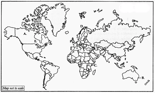 Ans:
Ans: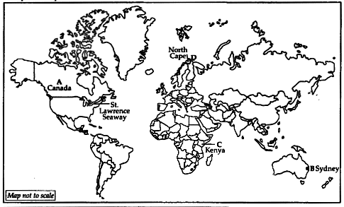
Q28.
Locate and label the following on the political outline map of India: [5]
A. State with lowest level of urbanisation
B. A major seaport in Karnataka state
C. City where software technology park has been established in Telangana
D. Raniganj coal mine
E. Largest tea producing state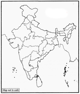 Ans:
Ans: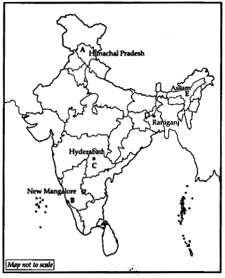
|
70 videos|340 docs|53 tests
|
FAQs on CBSE Sample Question Paper (2022-23) - 1 - Geography Class 11 - Humanities/Arts
| 1. What are the major subjects included in the CBSE Humanities/Arts stream? |  |
| 2. How can students prepare effectively for the CBSE Humanities/Arts exam? |  |
| 3. What career options are available for students after completing the CBSE Humanities/Arts stream? |  |
| 4. Is it necessary to take coaching classes for the CBSE Humanities/Arts exam preparation? |  |
| 5. How can students improve their writing skills for the CBSE Humanities/Arts exam? |  |


