CBSE Sample Question Paper (2022-23) - 2 | Geography Class 11 - Humanities/Arts PDF Download
Time Allowed: 2 hours
Maximum Marks: 80
General Instructions:
- All questions are compulsory.
- Question number 1 to 14 are Multiple choice questions carrying 1 mark each.
- Question number 15 to 16 are Multiple source-based questions carrying 3 marks each.
- Question number 17 to 21 are Short-answer questions carrying 3 marks each. Answer to each of these questions should not exceed 80-100 words.
- Question number 22 to 26 are Long-answer questions carrying 5 marks each. Answer to each of these questions should not exceed 150 words.
- Question number 27 and 28 are related to the identification or locating and labeling of geographical features on maps, carrying 5 marks each.
Q1. The term ‘Holistic Approach’ is related to [1]
(a) overall approach
(b) individualistic approach
(c) seasonal approach
(d) formal approach
Ans: (a) overall approach
Q2. The stars are localized lumps of gas within a: [1]
(a) nebula
(b) core
(c) gas
(d) hydrogen
Ans: (a) nebula
Q3. P-waves are similar to: [1]
(a) sound waves
(b) heat waves
(c) earth waves
(d) plane waves
Ans: (a) sound waves
Q4. The Continental Drift Theory was given in : [1]
(a) 1911
(b) 1921
(c) 1931
(d) 1941
Ans: (b) 1921
Q5. Which one of the following facts were not considered by those while discussing the concept of seafloor spreading: [1]
(a) Volcanic activity along the mid-oceanic ridges.
(b) Stripes of the normal and reverse magnetic field observed in rocks of the ocean floor.
(c) Distribution of fossils in different continents
(d) Age of rocks from the ocean floor
Ans: (c) Distribution of fossils in different continents
Q6. Which one of the following is not a single-element mineral : [1]
(a) Gold
(b) Silver
(c) Mica
(d) Graphite
Ans: (c) Mica
Q7. Stalagmites: [1]
(a) rise up from the floor of the caves
(b) rise from the roof of a cave
(c) rise from underground
(d) rise from the sinkhole
Ans: (a) rise up from the floor of the caves
Q8. In which one of the following regions the chemical weathering process is more dominant than the mechanical process : [1]
(a) Humid region
(b) Limestone region
(c) Arid region
(d) Glacier region
Ans: (b) Limestone region
Q9. The atmospheric layer important for human beings is : [1]
(a) Stratosphere
(b) Mesosphere
(c) Troposphere
(d) Ionosphere
Ans: (c) Troposphere
Q10. The atmosphere is mainly heated by the : [1]
(a) Short-wave solar radiation
(b) Reflected solar radiation
(c) Long-wave terrestrial radiation
(d) Scattered solar radiation
Ans: (c) Long-wave terrestrial radiation
Q11. Arrange the course of River Jhelum in India in the correct order: [1]
(i) Rises from a spring at Verinag situated at the foot of the Pir Panjal
(ii) Flows through Wular Lake
(iii) Flows through Srinagar
(iv) Joins the Chenab near Jhang in Pakistan Options:
(a) i, iii, ii, iv
(b) i, ii, iii, iv
(c) iv, iii, ii, i
(d) iii, ii, i, iv
Ans: (a) i, iii, ii, iv
Q12. Arrange the salinity of ocean water in the correct order: [1]
(i) Highly saline
(ii) Brackish
(iii) Marginal
(iv) Saline
Options:
(a) i, ii, iii, iv
(b) ii, iv, iii, i
(c) iii, ii, iv, i
(d) iv, i, ii, iii
Ans: (c) iii, ii, iv, i
Q13. If the surface air pressure is 1,000 MB, the air pressure at 1 km above the surface will be: [1]
(a) 700 MB
(b) 1,100 MB
(c) 900 MB
(d) 1,300 MB
Ans: (c) 900 MB
Q14. The small letters a, b, c, and d refer to the degree of severity of: [1]
(a) temperature
(b) weather
(c) climate
(d) humidity
Ans: (a) temperature
Q15. Read the case study and answer the following questions:
Unlike the parallels of latitude which are circles, the meridians of longitude are semi-circles that converge at the poles. If opposite meridians are taken together, they complete a circle, but they are valued separately as two meridians. The meridians intersect the equator at right angles. Unlike the parallels of latitude, they are all equal in length. For the convenience of numbering, the meridian of longitude passing through the Greenwich observatory (near London) has been adopted as the Prime Meridian by an international agreement and has been given the value of 0°.
The longitude of a place is its angular distance east or west of the Prime Meridian. It is also measured in degrees. The longitudes vary from 0° to 180° eastward and westward of the Prime Meridian. The part of the earth east of the Prime Meridian is called the eastern hemisphere and, in its west, referred to as the western hemisphere.
(i) The meridians of longitude are: [1]
(a) Circles
(b) Semi-circles
(c) Straight lines
(d) None of the above
Ans: (b) Semi-circles
(ii) The meridians of longitudes converge at the_______. [1]
(a) equator
(b) poles
(c) latitudes
(d) axis
Ans: (b) poles
(iii) The meridians intersect the Equator at_______angles. [1]
(a) intersecting
(b) right
(c) acute
(d) reflex
Ans: (b) right
Q16. Read the case study given below and answer any three of the questions that follow.
The destruction of the soil cover is described as soil erosion. The soil-forming processes and the erosional processes of running water and wind go on simultaneously. But generally, there is a balance between these two processes. The rate of removal of fine particles from the surface is the same as the rate of addition of particles to the soil layer. Sometimes, such a balance is disturbed by natural or human factors, leading to a greater rate of removal of soil.
Human activities too are responsible for soil erosion to a great extent. As the human population increases, the demand for land also increases. Forest and other natural vegetation are removed for human settlement, cultivation, grazing animals, and for various other needs. Wind and water are powerful agents of soil erosion because of their ability to remove soil and transport it. Wind erosion is significant in arid and semi-arid regions. In regions with heavy rainfall and steep slopes, erosion by running water is more significant.
Water erosion which is more serious and occurs extensively in different parts of India takes place mainly in the form of sheet and gully erosion. Sheet erosion takes place on level lands after a heavy shower and the soil removal is not easily noticeable. But it is harmful since it removes the finer and more fertile topsoil. Gully erosion is common on steep slopes. Gullies deepen with rainfall, cut the agricultural lands into small fragments, and make them unfit for cultivation.
A region with a large number of deep gullies or ravines is called a bad land topography. Ravines are widespread, in the Chambal basin. Besides this, they are also found in Tamil Nadu and West Bengal. The country is losing about 8,000 hectares of land to ravines every year.
(i) The soil forming processes and the erosional processes of running water and wind go on_______. [1]
(a) simultaneously
(b) separately
(c) differently
(d) None of the above
Ans: (a) simultaneously
(ii) Ravines are widespread in the_______basin. [1]
(a) Chambal
(b) Brahmaputra
(c) Himalayan
(d) Sunderbans
Ans: (a) Chambal
(iii) The country is losing about_______hectares of land to ravines every year. [1]
(a) 5,000
(b) 6,000
(c) 7,000
(d) 8,000
Ans: (d) 8,000
Q17. Name the experts who modified the Nebular Hypothesis. [3]
Ans: In 1950, Otto Schmidt in Russia and Carl Weizascar in Germany revised the ‘Nebular Hypothesis’, though they differed in details. They were of the opinion that the Sun was surrounded by a solar nebula containing mostly hydrogen and helium along with what may be termed as dust. The friction and collision of particles led to the formation of a disk-shaped cloud and the planets were formed through the process of accretion. However, scientists in the later periods took up the problems of the origin of the universe rather than that of just the Earth or the planets.
Q18. Discuss the important gases present in the atmosphere. [3]
Ans: The important gases present in the atmosphere are:
(1) Oxygen: Oxygen is important for breathing. It is the most combustible gas and it helps in the burning of fuel. Oxygen is the main source of energy and provides a solid base for industries. Oxygen extends up to 64 km but is concentrated at 16 km.
(2) Carbon dioxide: it is the heaviest gas and is confined to lower layers. Carbon dioxide can be found up to a height of 32 km. Though it is present in negligible quantity, it is important for vegetation. Carbon dioxide is meteorologically a very important gas as it is transparent to incoming solar radiation but opaque to outgoing terrestrial radiation. It absorbs a part of terrestrial radiation and reflects back some part of it toward the Earth’s surface. It is largely responsible for the greenhouse effect.
(3) Nitrogen: Nitrogen has no color, odor, or taste. Nitrogen generates protein in plants, which is the main source of food. Nitrogen extends up to 128 km. The atmosphere is composed of 78% nitrogen.
(4) Hydrogen: Hydrogen is a light gas and extends up to 11 km over heavier gases. It accounts for 0.01% of our atmosphere.
Q19. Explain the process of the hydrological cycle. [3]
Ans: The hydrological cycle, is the circulation of water within the Earth’s hydrosphere in different forms, i.e., liquid, solid, and gaseous phases. It also refers to the continuous exchange of water between the oceans, atmosphere, land surface, subsurface, and organisms. About 71% of the planetary water is found in the oceans. The remaining is held as freshwater in glaciers and ice caps, groundwater sources, lakes, soil moisture, atmosphere, streams, and within life. Nearly 59% of the water that falls on land returns to the atmosphere through evaporation from over the oceans as well as from other places. The remainder runs off on the surface, infiltrates into the ground or a part of it becomes a glacier.
Q20. What is an annual range of temperature? Explain it with the help of an example. [3]
Ans: The difference between the maximum average temperature and a minimum average temperature of a place over twelve months is known as the annual range of temperature.
Example: The maximum average temperature at Jodhpur is 33.9°C and the minimum average temperature is 14.9°C. Hence, the annual range of temperature at Jodhpur is 19°C (33.9°C-14.9°C).
Q21. What is a disaster? What are its two types? [3]
Ans: Disaster is an undesirable occurrence resulting from forces that are largely outside human control, which strikes quickly with little or no warning. It causes serious disruptions in life and property causing death and injury and therefore requires mobilization of efforts in excess of something which is normally provided by statutory emergency services. Two types of disasters are-natural disasters and man-made disasters.
Q22. Explain the food chain. [5]
Ans: The sequence of eating and being eaten and the resultant transfer of energy from one level to another is known as the food chain. Transfer of energy that occurs during the process of a food chain from one level to another is known as the flow of energy. However, food chains are not isolated from one another. For example, a mouse feeding on grain may be eaten by different secondary consumers (carnivores) and these carnivores may be eaten by other different tertiary consumers (top carnivores).
In such situations, each of the carnivores may consume more than one type of prey. As a result, the food chains get interlocked with one another. This interconnecting network of species is known as a food web. For example, a plant-eating beetle feeding on a paddy stalk is eaten by a frog, which is, in turn, eaten by a snake, which is then consumed by a hawk.
(1) Producers: The producers include all the green plants, which manufacture their own food through photosynthesis.
(2) Primary consumers: The primary consumers include herbivorous animals like deer, goats, mice, and all plant-eating animals.
(3) Carnivores: The carnivores include all flesh-eating animals like snakes, tigers, and lions.
(4) Certain carnivores that feed also on carnivores are known as top carnivores like hawks and mongooses.
(5) Decomposers: Decomposers are those that feed on dead organisms (for example, scavengers like vultures and crows), and further break down the dead matter by other decomposing agents like bacteria and various microorganisms.
There are two -types of food chains:
- Grazing food chain: In a grazing food chain, the first level starts with plants as producers and ends with carnivores as consumers at the last level, with the herbivores being at the intermediate level. There is a loss of energy at each level, which may be through respiration, excretion, or decomposition. The levels involved in a food chain range between three to five and energy is lost at each level.
- Detritus food chain: A detritus food chain is based on autotrophs energy capture initiated by grazing animals and involves the decomposition or breaking down of organic wastes and dead matter derived from the grazing food chain.
Q23. Write a detailed note on Kashmir or North-Western Himalayas. [5]
Ans: Kashmir or the North-Western Himalayas:
(1) It comprises a series of ranges such as the Karakoram, Ladakh, Zaskar, and Pir Panjal. The Northeastern part of the Kashmir Himalayas is a cold desert, which lies between the Greater Himalayas and the Karakoram ranges.
(2) Important glaciers of South Asia such as the Baltoro and Siachen are also found in this region. The Kashmir Himalayas are also famous for Karewa formations, which are useful for the cultivation of Zafran, a local variety of saffron.
(3) Some of the important passes of the region are Zoji La on the Great Himalayas, Banihal on the Pir Panjal, Photo La on the Zaskar, and Khardung La on the Ladakh range. Some of the important fresh-water lakes such as Dal and Wular and salt-water lakes such as Pangong Tso and Tso Moriri are also in this region.
(4) Kashmir and the North-Western Himalayas are well-known for their scenic beauty and picturesque landscape. The landscape of Himalayas is a major source of attraction for adventure tourists. Srinagar, the capital city of the state of Jammu and Kashmir, is located on the banks of the Jhelum river. Dal Lake in Srinagar presents an interesting physical feature. Jhelum in the valley of Kashmir is still in its youth stage and yet forms a meander- a typical feature associated with the mature stage in the evolution of fluvial landforms.
(5) The Southernmost part of this region consists of longitudinal valleys known as ‘duns’. Dehradun, Jammu dun, and Pathankot dun are important examples.
Q24. What kinds of steps have been taken by the Central Soil Conservation Board, set up by the Government of India? [5]
Ans: The Central Soil Conservation Board, set up by the Government of India, has prepared a number of plans for soil conservation in different parts of the country. These plans are based on the climatic conditions, the configuration of the land, and the social behavior of people. Even these plans are fragmental in nature. Integrated land use planning, therefore, seems to be the best technique for proper soil conservation. Lands should be classified according to their capability; land use maps should be prepared and lands should be put to the right uses. The final responsibility for achieving the conservation of arid will rest on the people who operate on it and receive the benefits.
Q25. Explain the features of the black soil. [5]
Ans: Features of black soil:
(1) Black soil covers most of the Deccan Plateau, which includes parts of Maharashtra, Madhya Pradesh, Gujarat, Andhra Pradesh, and some parts of Tamil Nadu.
(2) These soils are also known as the ‘Regur Soil’ or the ‘Black Cotton Soil’. The black soils are generally clayey, deep, and impermeable.
(3) They swell and become sticky when wet and shrink when dried. Therefore, during the dry season, these soils develop wide cracks. Thus, there occurs a kind of ‘self-plowing’.
(4) Because of this character of slow absorption and loss of moisture, the black soil retains the moisture for a very long time, which helps the crops, especially; the rainfed ones, to sustain even during the dry season.
(5) Chemically, the black soils are rich in lime, iron, magnesia, and alumina. They also contain potash. However, they lack phosphorous, nitrogen, and organic matter. The color of the soil ranges from deep black to grey.
Q26. What are earthquakes? What are the socio-environmental consequences of earthquakes? [5]
Ans: The Earthquakes result from a series of Earth movements brought about by a sudden release of energy during the tectonic activities in the Earth’s crust.
Socio-environmental consequences of the Earthquake:
(1) The idea of an Earthquake is often associated with fear and horror due to the scale, magnitude, and suddenness at which it spreads the disasters on the surface of the Earth without discrimination. It becomes a calamity when it strikes areas with a high density of population. It not only damages and destroys the settlements, infrastructure, transport and communication network, industries, and other developmental activities, but also robs the population of the material and socio-cultural gains that they have preserved over generations.
(2) It renders them homeless, which puts extra pressure and stress, particularly on the weak economy of developing countries.
(3) Earthquakes also have some serious and far-reaching environmental consequences. Surface seismic waves produce fissures on the upper layers of the Earth’s crust through which water and other volatile materials gush out, inundating the neighboring areas.
(4) Earthquakes are also responsible for landslides and often cause obstructions in the flow of rivers and channels resulting in the formation of reservoirs. Sometimes, rivers also change their course causing floods and other calamities in the affected areas.
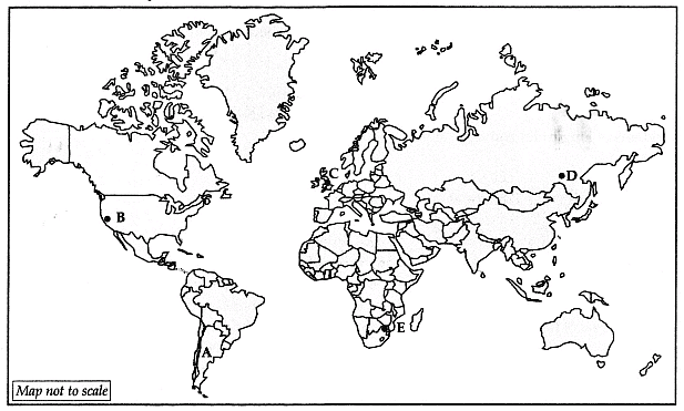
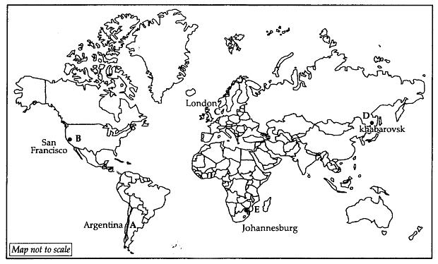
Q27. Study the given world map and identify the features marked as A, B, C, D and E. Also write their correct name on the map : [5]
A. A country where commercial livestock rearing is practiced
B. Silicon Valley area
C. A major seaport in Europe
D. A terminal station of the Trans-Siberian Railway.
E. An international airport
Ans:
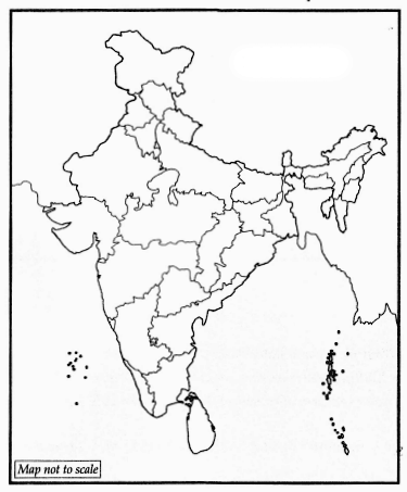
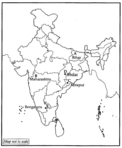
Q28. Locate and label the following on the political outline map of India : [5]
A. An out-migrating state
B. Leading state of war production in India
C. Koraput bauxite mine
D. Bhilai (Iron and Steel Plant)
E. An international airport in Karnataka state
 Ans:
Ans:
|
70 videos|289 docs|44 tests
|


