
Best Study Material for Year 7 Exam
Year 7 Exam > Year 7 Notes > Map Symbols, Direction and Contour Lines
Map Symbols, Direction and Contour Lines - Year 7 PDF Download
| Table of contents |
|
| Introduction |
|
| Maps |
|
| What are map symbols? |
|
| How do we show height on a map? |
|
Introduction
- A compass is a tool utilized for determining direction. A four-point compass provides a general direction, while a sixteen-point compass offers more precise directions.
- Map symbols are representations indicating what can be identified in a particular area. Each distinct feature of the landscape is denoted by a unique symbol.
- Contour lines are lines that connect regions of equal elevation on a map. By observing the spacing between contour lines in an area, one can discern whether the terrain is steep or flat.
Maps
A map is a visual representation of a location from a top-down perspective. The Ordnance Survey (OS) serves as the primary mapping agency for Great Britain, crafting detailed maps essential for geographers. Maps play a crucial role in guiding us on our travels.
Measuring Direction
Determining direction involves the use of a compass, a tool equipped with a magnetized pointer indicating north, east, south, and west. There exist three main types of compasses:
- A four-point compass is a basic tool with cardinal directions: north, east, south, and west.
- An eight-point compass provides more precision, adding north-east, south-east, north-west, and south-west to the cardinal directions.
- A sixteen-point compass offers even greater precision, including intermediate directions like north-north-east and west-south-west.
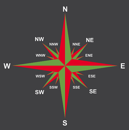 A sixteen-point compass
What are map symbols?
- Maps convey vast information about the depicted land areas. Due to the abundance of features, text alone isn't sufficient, hence the use of map symbols.
- These symbols encompass letters, colored regions, images, or lines, aiding in indicating various features like roads, viewpoints, bus stops, train stations, schools, and post offices.
- For instance, on Ordnance Survey (OS) maps, map symbols represent different aspects such as transport options, key services, and tourist attractions:
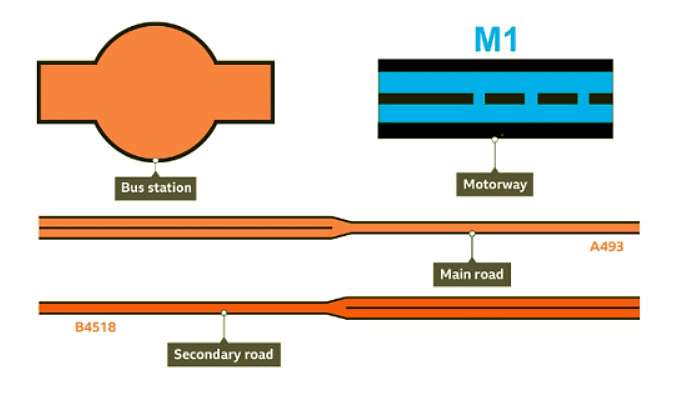
- These map symbols provide information on transportation choices in a region.
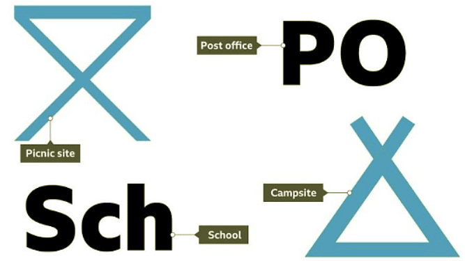
These map symbols indicate the locations of essential services within an area.
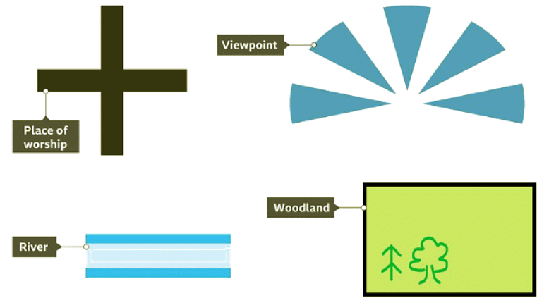
These map symbols show where to find attractions worth visiting in an area.
How do we show height on a map?
To show height on a map, contour lines are used.
 |
Download the notes
Map Symbols, Direction and Contour Lines
|
Download as PDF |
Download as PDF
What do contour lines signify?
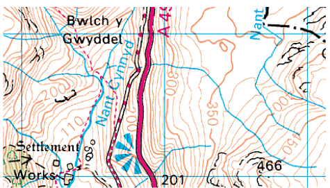
- Contour lines connect points of equal elevation and are typically depicted in orange on an Ordnance Survey (OS) map.
- The numerical value displayed on a contour line indicates the altitude above sea level, measured in meters.
- Normally, the spacing between contour lines is five meters, although in rugged terrains, such as mountainous areas, this interval may be extended to ten meters.
What do contour lines show?
The spacing between contour lines indicates the slope of the terrain:
- Widely spaced contour lines suggest a flat landscape.
- Contour lines that are closely packed together indicate steep terrain.
 Contour lines show height on a map
 |
Take a Practice Test
Test yourself on topics from Year 7 exam
|
Practice Now |
Practice Now
Spot Heights and Triangulation Pillars
- A map can feature spot heights, denoting the precise elevation of a specific point above sea level in meters. These values are typically displayed in small black text on the map.
- Triangulation pillars, denoted by a small blue triangle symbol on maps, are concrete pillars marking the highest points of the land. They were utilized by the OS in the past to enhance the accuracy of maps of Great Britain.
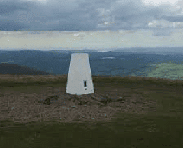 Triangulation points are most commonly found at the highest point of the land.
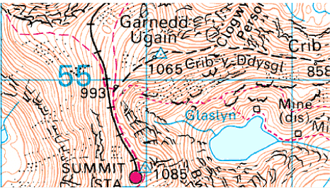
On this map, the spot height written in black shows that the height of the summit at the triangulation pillar at Garnedd Ugain (a mountain in Wales) is 1,065 metres exactly. At the bottom of the map we can see the summit of Mount Snowdon, the highest mountain in Wales, is 1,085 metres.
Question for Map Symbols, Direction and Contour Lines
Try yourself:
What is the purpose of map symbols?View Solution

FAQs on Map Symbols, Direction and Contour Lines - Year 7
| 1. What are map symbols used for? |  |
| 2. How are direction symbols displayed on a map? | |
Ans. Direction symbols on a map typically include a compass rose or arrow, which indicates the orientation of the map in relation to north, south, east, and west.
| 3. What do contour lines on a map represent? | |
Ans. Contour lines on a map show the shape and elevation of the land. They connect points of equal elevation, helping to visualize the height and steepness of the terrain.
| 4. How can one determine the height of a location on a map using contour lines? | |
Ans. By looking at the spacing and arrangement of contour lines on a map, one can determine the height of a location. Closer contour lines indicate steeper terrain, while wider spacing suggests flatter areas.
| 5. Why is it important to understand map symbols and contour lines when reading a map? | |
Ans. Understanding map symbols and contour lines is crucial for navigation and planning outdoor activities. It helps individuals interpret the features of the landscape accurately and navigate safely in unfamiliar terrain.
Related Exams
About this Document

Apr 16, 2025
Last updated
Document Description: Map Symbols, Direction and Contour Lines for Year 7 2025 is part of Year 7 preparation. The notes and questions for Map Symbols, Direction and Contour Lines have been prepared according to the Year 7 exam syllabus. Information about Map Symbols, Direction and Contour Lines covers topics like Introduction, Maps, What are map symbols?, How do we show height on a map? and Map Symbols, Direction and Contour Lines Example, for Year 7 2025 Exam. Find important definitions, questions, notes, meanings, examples, exercises and tests below for Map Symbols, Direction and Contour Lines.
Introduction of Map Symbols, Direction and Contour Lines in English is available as part of
our Year 7 preparation & Map Symbols, Direction and Contour Lines in Hindi for Year 7
courses. Download more important topics, notes, lectures and mock test series for Year 7
Exam by signing up for free. Year 7: Map Symbols, Direction and Contour Lines - Year 7
Description
Full syllabus notes, lecture & questions for Map Symbols, Direction and Contour Lines - Year 7 - Year 7 | Plus excerises question with solution to help you revise complete syllabus | Best notes, free PDF download
Information about Map Symbols, Direction and Contour Lines
In this doc you can find the meaning of Map Symbols, Direction and Contour Lines defined & explained in the simplest way possible.
Besides explaining types of Map Symbols, Direction and Contour Lines theory,
EduRev gives you an ample number of questions to practice Map Symbols, Direction and Contour Lines tests, examples and also practice Year 7 tests.
Download as PDF

Related Searches
Map Symbols
,video lectures
,Previous Year Questions with Solutions
,ppt
,practice quizzes
,Map Symbols
,MCQs
,past year papers
,Direction and Contour Lines - Year 7
,Map Symbols
,Summary
,Extra Questions
,Sample Paper
,Direction and Contour Lines - Year 7
,Important questions
,Direction and Contour Lines - Year 7
,Semester Notes
,Exam
,shortcuts and tricks
,Viva Questions
,Free
,Objective type Questions
,mock tests for examination
,study material
;


Additional Information about Map Symbols, Direction and Contour Lines for Year 7 Preparation
Map Symbols, Direction and Contour Lines Free PDF Download
The Map Symbols, Direction and Contour Lines is an invaluable resource that delves deep into the core of the Year 7 exam.
These study notes are curated by experts and cover all the essential topics and concepts, making your preparation more efficient and effective.
With the help of these notes, you can grasp complex subjects quickly, revise important points easily,
and reinforce your understanding of key concepts. The study notes are presented in a concise and easy-to-understand manner,
allowing you to optimize your learning process. Whether you're looking for best-recommended books, sample papers, study material,
or toppers' notes, this PDF has got you covered. Download the Map Symbols, Direction and Contour Lines now and kickstart your journey towards success in the Year 7 exam.
Importance of Map Symbols, Direction and Contour Lines
The importance of Map Symbols, Direction and Contour Lines cannot be overstated, especially for Year 7 aspirants.
This document holds the key to success in the Year 7 exam.
It offers a detailed understanding of the concept, providing invaluable insights into the topic.
By knowing the concepts well in advance, students can plan their preparation effectively.
Utilize this indispensable guide for a well-rounded preparation and achieve your desired results.
Map Symbols, Direction and Contour Lines Notes
Map Symbols, Direction and Contour Lines Notes offer in-depth insights into the specific topic to help you master it with ease.
This comprehensive document covers all aspects related to Map Symbols, Direction and Contour Lines.
It includes detailed information about the exam syllabus, recommended books, and study materials for a well-rounded preparation.
Practice papers and question papers enable you to assess your progress effectively.
Additionally, the paper analysis provides valuable tips for tackling the exam strategically.
Access to Toppers' notes gives you an edge in understanding complex concepts.
Whether you're a beginner or aiming for advanced proficiency, Map Symbols, Direction and Contour Lines Notes on EduRev are your ultimate resource for success.
Map Symbols, Direction and Contour Lines Year 7 Questions
The "Map Symbols, Direction and Contour Lines Year 7 Questions" guide is a valuable resource for all aspiring students preparing for the
Year 7 exam. It focuses on providing a wide range of practice questions to help students gauge
their understanding of the exam topics. These questions cover the entire syllabus, ensuring comprehensive preparation.
The guide includes previous years' question papers for students to familiarize themselves with the exam's format and difficulty level.
Additionally, it offers subject-specific question banks, allowing students to focus on weak areas and improve their performance.
Study Map Symbols, Direction and Contour Lines on the App
Students of Year 7 can study Map Symbols, Direction and Contour Lines alongwith tests & analysis from the EduRev app,
which will help them while preparing for their exam. Apart from the Map Symbols, Direction and Contour Lines,
students can also utilize the EduRev App for other study materials such as previous year question papers, syllabus, important questions, etc.
The EduRev App will make your learning easier as you can access it from anywhere you want.
The content of Map Symbols, Direction and Contour Lines is prepared as per the latest Year 7 syllabus.
|
© EduRev
|
Education Revolution
|


|


Signup to see your scores
go up
within 7 days!
within 7 days!
Takes less than 10 seconds to signup