CBSE Sample Question Paper (2022-23) - 8 | Geography Class 11 - Humanities/Arts PDF Download
Time Allowed: 2 Hours
Maximum Marks: 80
General Instructions:
- All questions are compulsory.
- Question number 1 to 14 are Multiple choice questions carrying 1 mark each.
- Question number 15 to 16 are Multiple source based questions carrying 3 marks each.
- Question number 17 to 21 are Short-answer questions carrying 3 marks each. Answer to each of these questions should not exceed 80 – 100 words.
- Question number 22 to 26 are Long-answer questions carrying 5 marks each. Answer to each of these questions should not exceed 150 words.
- Question number 27 and 28 are related to identification or locating and labelling of geographical features on maps, carrying 5 marks each.
Q1. Which of the following scholars coined the term ‘Geography’: [1]
(a) Herodotus
(b) Galileo
(c) Eratosthenes
(d) Aristotle
Ans: (b) Galileo
Q2. Which one of the following figures represents the age of the earth: [1]
(a) 4.6 million years
(b) 13.7 billion years
(c) 4.6 billion years
(d) 13.7 trillion years
Ans: (c) 4.6 billion years
Q3. Which one of the following earthquake waves is more destructive: [1]
(a) P-waves
(b) S-waves
(c) Surface waves
(d) None of the above
Ans: (a) P-waves
Q4. The location where sinking of a plate occurs is called a: [1]
(a) Subduction Zone
(b) Reduction Zone
(c) Induction Zone
(d) Deduction Zone
Ans: (a) Subduction Zone
Q5. Igneous, metamorphic and sedimentary rocks are known as: [1]
(a) crustal rocks
(b) banding rocks
(c) consolidated rocks
(d) broken rocks
Ans: (a) crustal rocks
Q6. The chemical addition of water is called as: [1]
(a) hydration
(b) dehydration
(c) reduction
(d) oxidation
Ans: (a) hydration
Q7. Debris avalanche can be included in the category of: [1]
(a) Landslides
(b) Slow flow mass movements
(c) Rapid flow mass movements
(d) Subsidence
Ans: (c) Rapid flow mass movements
Q8. Dry hot deserts are good places for the formation of: [1]
(a) rain
(b) flats
(c) sand dune
(d) vegetation
Ans: (c) sand dune
Q9. ______ is the most important layer for all biological activity. [1]
(a) Troposphere
(b) Mesosphere
(c) Ionosphere
(d) Stratosphere
Ans: (a) Troposphere
Q10. The earth after being heated by insolation transmits the heat to the atmospheric layers near to the earth in: [1]
(a) long wave form
(b) short wave form
(c) medium wave form
(d) average wave form
Ans: (a) long wave form
Q11. The winds that blow from the west toward the east in the middle latitudes between 30 and 60 degrees latitude are known as: [1]
(a) easterlies wind
(b) westerlies wind
(c) hurricane
(d) cyclone
Ans: (b) westerlies wind
Q12. Arrange the Nitrogen Cycle in the correct order: [1]
(i) Ammonification
(ii) Nitrogen fixation
(iii) Assimilation
(iv) Nitrification
Options:
(a) i. iv, iii, i
(b) ii, iv, iii, i
(c) iv, iii, ii, i
(d) i, ii, iii, iv
Ans: (a) i. iv, iii, i
Q13. Which one of the following is the most important constituent of the atmosphere for human beings: [1]
(a) Water vapour
(b) Nitrogen
(c) Dust particle
(d) Oxygen
Ans: (a) Water vapour
Q14. Which one of the following is suitable for Koeppen’s “A” type of climate: [1]
(a) High rainfall in all the months
(b) Mean monthly temperature of the coldest month more than freezing point
(c) Mean monthly temperature of all the months more than 18°C
(d) Average temperature for all the months below 10°C
Ans: (a) High rainfall in all the months
Q15. Read the case study given below and answer any three of the questions that follow.
Indian agriculture has been heavily dependent on the monsoon rainfall. Droughts and floods are the two accompanying features of Indian climate. According to some estimates, nearly 19 per cent of the total geographical area of the country and 12 per cent of its total population suffer due to drought every year.
About 30 per cent of the country’s total area is identified as drought prone affecting around 50 million people. It is a common experience that while some parts of the country reel under floods, there are regions that face severe drought during the same period. Moreover, it is also a common sight to witness that one region suffers due to floods in one season and experiences drought in the other. This is mainly because of the large-scale variations and unpredicability in the behaviour of the monsoon in India. Thus, droughts are widespread and common phenomena in most parts of the country, but these are most recurrent and severe in some and not so in others.
(i) ______ and floods are the two accompanying features of Indian climate. [1]
(a) Droughts
(b) Tsunami
(c) Hurricanes
(d) Cyclones
Ans: (a) Droughts
(ii) How much percentage of geographical area of the country suffers from drought every year? [1]
(a) 15
(b) 17
(c) 19
(d) 21
Ans: (c) 19
(iii) About ______ per cent of the country’s total area is identified as drought prone. [1]
(a) 15
(b) 20
(c) 25
(d) 30
Ans: (d) 30
Q16. Read the case study given below and answer any three of the questions that follow.
The average annual rainfall in India is about 125 cm, but it has great spatial variations. Areas of High Rainfall: The highest rainfall occurs along the west coast, on the Western Ghats, as well as in the sub-Himalavan areas is the northeast and the hills of Meghalaya. Here the rainfall exceeds 200 cm. In some parts of Khasi and Jaintia hills, the rainfall exceeds 1,000 cm.
In the Brahmaputra valley and the adjoining hills, the rainfall is less than 200 cm. Areas of Medium Rainfall: Rainfall between 100- 200 cm is received in the southern parts of Gujarat, East Tamil Nadu, northeastern Peninsula covering Odisha, Jharkhand, Bihar, eastern Madhya Pradesh, northern Ganga plain along the sub-Himalayas and the Cachar Valley and Manipur.
Areas of Low Rainfall: Western Uttar Pradesh, Delhi, Haryana, Punjab, Jammu and Kashmir, eastern Rajasthan, Gujarat and Deccan Plateau receive rainfall between 50-100 cm. Areas of Inadequate Rainfall: Parts of the Peninsula, especially in Andhra Pradesh, Karnataka and Maharashtra, Ladakh and most of western Rajasthan receive rainfall below 50 cm. Snowfall is restricted to the Himalayan region.
(i) What is the average rainfall received in India? [1]
(a) 121 cm
(b) 125 cm
(c) 130 cm
(d) 135 cm
Ans: (b) 125 cm
(ii) How much rainfall does the Brahmaputra valley receive? [1]
(a) More than 200 cm
(b) Less than 200 cm
(c) More than 300 cm
(d) Less than 300 cm
Ans: (b) Less than 200 cm
(iii) How much rainfall does Punjab, Haryana and Delhi receive? [1]
(a) Between 40- 80 cm
(b) Between 80- 100 cm
(c) Between 50-100 cm
(d) Between 100-150 cm
Ans: (c) Between 50-100 cm
Q17. Discuss the forces that are held responsible for the drifting of the continents. [3]
Ans: Forces that are held responsible for the drifting of the continents are as follows:
Wegener suggested that the movement responsible for the drifting of the continents was caused by pole-fleeing force and tidal force.
(i) The polar-fleeing force relates to the rotation of the Earth. You are aware of the fact that the Earth is not a perfect sphere; it has a bulge at the equator. This bulge is due to the rotation of the Earth.
(ii) The second force that was suggested by Wegener is the tidal force, which occurs due to the attraction of the Moon and the Sun that develops tides in oceanic waters.
(iii) Wegener believed that these forces would become effective when applied over many million years. However, most of the scholars considered these forces very inadequate.
Q18. When does condensation take place? [3]
Ans: In free air, condensation results from cooling around very small particles termed as hygroscopic condensation nuclei. Particles of dust, smoke and salt from the ocean are particularly good nuclei because they absorb water. Condensation also takes place when the moist air comes in contact with some colder object and it may also take place when the temperature is close to the dew point. Condensation, therefore, depends upon the amount of cooling and the relative humidity of the air.
Q19. Why are tides important? [3]
Ans: Tides are important because:
(i) Since tides are caused by the Earth-Moon-Sun positions, which are known accurately, the tides can be predicted well in advance. This helps the navigators and fishermen plan their activities.
(ii) Tidal flows are of great importance in navigation. Tidal heights are very important, especially harbours near rivers and within estuaries having shallow ‘bars’ at the entrance, which prevent ships and boats from entering into the harbour.
(iii) Tides are also helpful in desilting the sediments and in removing polluted water from river estuaries. Tides are used to generate electrical power (in Canada, France, Russia, and China). A 3 MW tidal power project at Durgaduani in Sunderbans of West Bengal is underway.
Q20. When was the comprehensive Wildlife Act enacted and what are its objectives? [3]
Ans: The comprehensive Wildlife Act was enacted in 1972. The main objectives of this Act are:
(i) To protect the endangered species listed in the schedule of the Act.
(ii) To provide legal support to the conservation areas of the country classified as national parks, sanctuaries and closed areas.
(iii) To make punishments more stringent. The Act has also made provisions for the protection of specified plant species and conservation of endangered species of wild animals.
Q21. Explain the spatio-temporal distribution of tropical cyclones in India. [3]
Ans: (i) Owing to its peninsular shape surrounded by the Bay of Bengal in the East and the Arabian Sea in the West, the tropical cyclones in India also originate in these two important locations.
(ii) Though most of the cyclones originate between 10°–15° North latitudes during the monsoon season, yet in case of the Bay of Bengal, cyclones mostly develop during the months of October and November. Here, they originate between 16°–2° N latitudes and to the west of 92° E.
(iii) By July, the place of origin of these storms shifts to around 18° N latitude and West of 90° E near the Sunderbans Delta.
Q22. How can biodiversity be conserved? [5]
Ans: If species of plants and animals become endangered, they cause degradation in the environment, which may threaten human being’s own existence. There is an urgent need to educate people to adopt environment-friendly practices and reorient their activities in such a way that our development is harmonious with other life forms and is sustainable.
There is an increasing consciousness of the fact that such conservation with sustainable use is possible only with the involvement and cooperation of local communities and individuals. For this, the development of institutional structures at local level is necessary. The critical problem is not merely the conservation of species nor the habitat but the continuation of the process of conservation.
The Government of India along with 155 other nations has signed the Convention of Biodiversity at the Earth Summit held at Rio de Janeiro, Brazil, in June 1992. The world conservation strategy has suggested the following steps for biodiversity conservation:
- Efforts should be made to preserve the species that are endangered.
- Prevention of extinction requires proper planning and management.
- Varieties of food crops, forage plants, timber trees, livestock, animals, and their wild relatives should be preserved.
- Each country should identify habitats of wild relatives and ensure their protection.
- Habitats where species feed, breed, rest and nurse their young should be safeguarded and protected.
- International trade in wild plants and animals to be regulated.
Q23. Write a note on the important tributaries of the Ganga river System. [5]
Ans: The Ganga is the most important river of India both from the point of view of its basin and cultural significance.
- Important tributaries of the Ganga system are:
The Yamuna, western most and the longest tributary of the Ganga, has its source in the Yamunotri glacier on the Western slopes of Banderpunch range (6,316 km). It joins the Ganga at Prayag (Allahabad). Much of its water feeds the Western and Eastern Yamuna and the Agra canals for irrigation purposes. - The Chambal rises near Mhow in the Malwa plateau of Madhya Pradesh and flows Northwards through a gorge upwards of Kota, in Rajasthan, where the Gandhi Sagar Dam has been constructed. From Kota, it traverses down to Bundi, Sawai Madhopur and Dholpur, and finally joins the Yamuna. The Chambal is famous for its badland topography called the Chambal ravines.
- The Gandak comprises two streams, namely Kaligandak and Trishulganga. It rises in the Nepal Himalayas between the Dhaulagiri and Mount Everest and drains the central part of Nepal. It enters the Ganga plain in Champaran district of Bihar and joins the Ganga at Sonpur near Patna.
- The Ghaghara originates in the glaciers of Mapchachungo. After collecting the waters of its tributaries – Tila, Seti and Beri, it comes out of the mountain, cutting a deep gorge at Shishapani. The river Sarda (Kali or Kali Ganga) joins it in the plain before it finally meets the Ganga at Chhapra.
- The Kosi is an antecedent river with its source to the North of Mount Everest in Tibet, where its mainstream Arun rises. After crossing the Central Himalayas in Nepal, it is joined by the Son Kosi from the West and the Tamur Kosi from the East. It forms Sapt Kosi after uniting with the river Arun.
- The Damodar occupies the eastern margins of the Chotanagpur Plateau where it flows through a rift valley and finally joins the Hugli. The Barakar is its main tributary. Once known as the ‘sorrow of Bengal’, the Damodar has been now tamed by the Damodar Valley Corporation, a multipurpose project.
- The Mahananda is another important tributary of the Ganga rising in the Darjeeling hills. It joins the Ganga as its last left bank tributary in West Bengal.
- The Son is a large South bank tributary of the Ganga, originating in the Amarkantak plateau. After forming a series of waterfalls at the edge of the plateau, it reaches Arrah, west of Patna, to join the Ganga.
Q24. What is global warming? What are the effects of global warming? [5]
Ans: Global warming, also referred to as climatic change, is the observed century-scale rise in the average temperature of the Earth’s climate system and its related effects.
Effects of global warming are:
- The temperature of the world is significantly increasing. Carbon dioxide produced by human activities is a major source of concern. This gas, released to the atmosphere in large quantities by burning of fossil fuel, is increasing gradually.
- Other gases like methane, chlorofluorocarbons, and nitrous oxide, which are present in much smaller concentrations in the atmosphere, together with carbon dioxide, are known as greenhouse gases. These gases are better absorbers of longwave radiations than carbon dioxide, and so, are more effective at enhancing the greenhouse effect.
- Global warming has led to the rise in the sea level and melting of glaciers and sea ice due to warming. According to the current prediction, on an average, the sea level will rise 48 cm by the end of the 21st century. This would increase the incidence of annual flooding.
- The climatic change would promote insect-borne diseases like malaria, and lead to a shift in climatic boundaries, making some regions wetter and others drier.
- The agriculture pattern would shift and the human population, as well as the ecosystem, would experience change.
Q25. Wind and water are two important agents of soil erosion. Explain. [5]
Ans: Wind and water are powerful agents of soil erosion because of their ability to remove soil and transport it. Wind erosion is significant in arid and semi-arid regions. In regions with heavy rainfall and steep slopes, erosion by running water is more significant. Water erosion, which is more serious and occurs extensively in different parts of India, takes place mainly in the form of sheet and gully erosion. Sheet erosion takes place on level lands after a heavy shower and the soil removal is not easily noticeable.
However, it is harmful since it removes the finer and more fertile topsoil. Gully erosion is common on steep slopes. Gullies deepen with rainfall, they cut the agricultural lands into small fragments and make them unfit for cultivation. A region with a large number of deep gullies or ravines is called badland topography. Ravines are widespread in the Chambal basin. Besides this, gullies are also found in Tamil Nadu and West Bengal. The country is losing about 8,000 hectares of land to ravines every year.
Q26. What steps have been taken upto Conserve Forests? [5]
Ans: Steps that have been taken up to conserve forests are:
(i) Social forestry: It means the management and protection of forests and afforestation on barren lands with the purpose of helping in the environmental, social and rural development. The National Commission on Agriculture (1976) has classified social forestry into three categories:
(a) Urban forestry: It pertains to the raising and management of trees on public and privately owned lands in and around urban centres such as green belts, parks, roadside avenues, industrial and commercial green belts, etc.
(b) Rural forestry: It lays emphasis on promotion of agro-forestry and community forestry.
(c) Agro-forestry: It is the raising of trees and agriculture crops on the same land inclusive of the waste patches. It combines forestry with agriculture, thus, altering the simultaneous production of food, fodder, fuel, timber and fruit.
(ii) Community forestry: It involves the raising of trees on public or community land such as the village pasture and temple land, roadside, canal bank, strips along railway lines, and schools etc. Community forestry programme aims at providing benefits to the community as a whole. Community forestry provides a means under which the people of landless classes can associate themselves in tree raising and thus, get those benefits which otherwise are restricted for landowners.
(iii) Farm forestry: It is a term applied to the process under which farmers grow trees for commercial and non commercial purposes on their farmlands. Forest departments of various states distribute seedlings of trees free of cost to small and medium farmers. Several lands such as the margins of agricultural fields, grasslands and pastures, land around homes and cow sheds may be used for raising trees under non-commercial farm forestry.
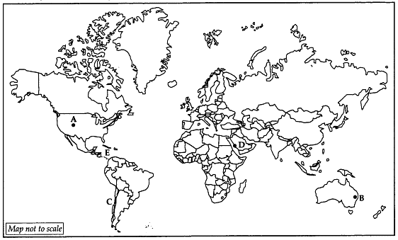
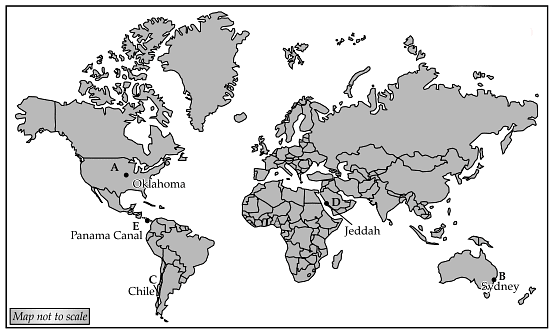
Q27. In the given outline map of the world there are five items marked as A, B, C, D and E. Identify the features with the help of information given below and write their correct names on the map: [5]
A. An area of mixed farming
B. A major seaport
C. An area of Mediterranean farming
D. A major international airport
E. Major inland waterway Ans:
Ans:
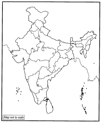
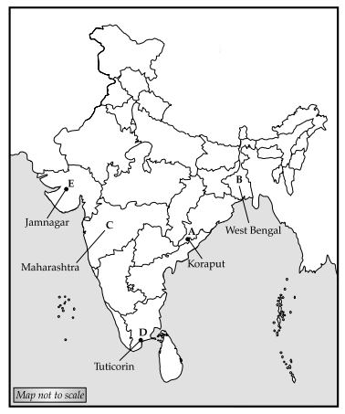
Q28. Locate and label the following on the political outline map of India: [5]
A. A bauxite mine
B. Largest jute producing state of India
C. An in migrating state
D. A major seaport
E. An oil refinery Ans:
Ans:
|
70 videos|289 docs|44 tests
|


