Physiography of Bihar: Location and Geological Structure - BPSC (Bihar) PDF Download
Introduction
Bihar, situated in eastern India, is a landlocked state bordered by West Bengal to the east, Jharkhand to the south, Uttar Pradesh to the west, and Nepal to the north. Covering an area of 94,163 sq km, it ranks as the twelfth-largest state in both area and population.
Physiography of Bihar: Location and Geological Structure
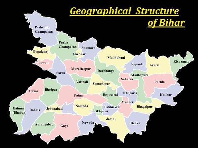
Location
- Bihar is situated in eastern India between latitudes 24°20’10″N and 27°31’15″N and longitudes 83°19’50″E and 88°17’40″E.
- It is a landlocked state located in a subtropical area within the temperate zone.
- Bihar's location places it between the humid West Bengal to the east and the less humid Uttar Pradesh to the west, making it a transitional region in terms of climate, economy, and culture. It is bordered by Jharkhand to the south and Nepal to the north.
- The Ganges River runs through the center of Bihar, dividing it into North Bihar and South Bihar.
- The state's average elevation is approximately 173 feet above sea level.
- Bihar shares its borders with Uttar Pradesh, Jharkhand, and West Bengal, and also with Nepal to the north, with a border length of 601 km.
- Seven districts in Bihar border Nepal from west to east: West Champaran, East Champaran, Sitamarhi, Madhubani, Supaul, Araria, and Kishanganj.
- Seven districts share a border with Uttar Pradesh from north to south: West Champaran, Gopalganj, Siwan, Saran, Bhojpur, Buxar, and Kaimur.
- Eight districts border Jharkhand from west to east: Rohtas, Aurangabad, Gaya, Nawada, Jamui, Banka, Bhagalpur, and Katihar.
- Three districts share a border with West Bengal from north to south: Kishanganj, Purnia, and Katihar.
- Rivers that form boundaries with Uttar Pradesh in some areas include the Ganga, Ghaghara, and Gandak.
- The Sone River forms a boundary with Jharkhand in the Rohtas district.
Topography of Bihar
Bihar features a variety of landscapes, including: 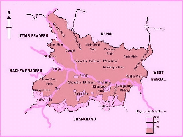
- The Himalayas: Located in the north, the Himalayan Mountains separate Bihar from Nepal. This range includes notable peaks like Kanchenjunga, Makalu, and Everest. The region is home to many rare plants and animals, thriving in its steep slopes, high altitudes, and dense forests. The population in this area is low, with only a few small towns and villages.
- The Gangetic Plain: This extensive alluvial plain spans most of central and southern Bihar. Formed by sediment from the Ganges River, the plain has fertile soil and a flat landscape, coupled with a hot and humid climate. This area is densely populated, hosting the state capital, Patna. Most residents are farmers, cultivating primary crops like rice, wheat, and sugarcane.
- The Chota Nagpur Plateau: Situated in the southern region of Bihar, this hilly area consists of low hills and plateaus. Its rugged terrain, deep valleys, and lush forests make it distinctive. The plateau is significant for mining, possessing rich deposits of coal, iron ore, and bauxite. Additionally, it is known for stunning natural beauty, featuring waterfalls, lakes, and wildlife sanctuaries.
Landforms
Bihar is divided into three physical and structural regions:
- The Southern Plateau Region
- Bihar’s Gangetic Plain
- The Shivalik Region
The northern rocks are younger, whereas the southern rocks are older. The north-west is the Terai region, the central region is the Gangetic plain, and the south is the Plateau region. The Bihar plain is the most recently formed of these divisions.
- Shivalik Region:
- The West Champaran district lies in the sub-Himalayan foothills of the Shivalik range, extending 32 km in length and 6-8 km in width.
- This area features a band of moist deciduous woodland, which includes reeds, grass, scrub, and trees.
- Bihar’s Gangetic Plain:
- The Gangetic Plain separates the Southern Plateau from the Northern Mountains, with its northern and southern boundaries defined by the 150-meter contour line.
- The Ganges River divides this vast plain into two parts: North Bihar and South Bihar.
- The Northern Bihar Plain includes regions such as Samastipur, Begusarai, Saharsa, Katihar, and parts of East and West Champaran (Terai areas with higher elevation).
- Major rivers like Saryu, Gandak, Burhi Gandak, Bagmati, Kamla-Balan, Kosi, and Mahananda, along with their tributaries, drain this region.
- The southern Bihar Plain, narrower and triangular in shape, is characterized by several hills, including those in Gaya, Rajgir, Giriyak, Bihar Sharif, Sheikhpura, Jamalpur, and Kharagpur.
- Southern Plateau Region:
- This region is situated between Banka in the East and the Kaimur district in the West.
- It is composed of hard rocks such as gneiss, schist, and granite.
- The area features conical hills formed from batholim, including Pretshil, Ramshila, and Jethian Hill.
Geological Structure of Bihar
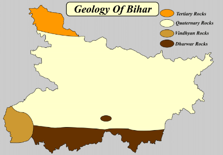
Bihar features a unified geological framework that spans from the oldest Dharwar Rock System in the southern part of the state, bordering Jharkhand, to the youngest Quaternary Rock System in the central region, bridging the gap between the Dharwar System and the Tertiary Rock System of the North-Western Terai Region.
A four-part division of Bihar’s geological structure is as follows:
- Dharwar Rock System
- Vindhyan Rock System
- Tertiary Rock System
- Quaternary Rock System
Given below is the detailed information about each of the rock system of Bihar:
Dharwar Rock System
- This formation is part of the oldest Archaean Rock System, dating back 3.1 to 2.1 billion years.
- It extends into the southern parts of Bihar, including Aurangabad, Gaya, Nawada, Jamui, and Munger.
- Composed of Quartzite, Phyllite, Gneiss, Schist, Shale, and Slate, with Schist and mica being particularly common.
- Named after the Dharwar district in Karnataka, known for similar rock types.
Vindhyan Rock System
- Located in the Son Valley of Rohtas and Kaimur districts.
- This system is part of the Purana Rock System, formed between 1.3 and 0.6 billion years ago.
- Named after the Vindhyan Ranges.
- Consists mainly of Sandstone, Limestone, Dolomite, Quartzite, and Shale, with significant reserves of Limestone and Pyrite used commercially.
Tertiary Rock System
- Developed during the formation of the Himalayan Ranges, 60 to 70 million years ago.
- Found in the Himalayan Terai region of Bihar, specifically in Western Champaran and the Terai Region of the Shivalik Ranges.
- Created from sediments of the Tethys Sea, shaped by tectonic movements of the Indian and Eurasian plates.
- Composed of Sandstone, Sandy Shale, Mudstone, and Conglomerate.
Quaternary Rock System
- Lies between the northern Chhotanagpur plateau and the southern Himalayan Terai region.
- Formation began around 1 million years ago during the Pleistocene epoch and continues today.
- Resulted from the rapid deposition of alluvium by rivers like the Ganga, Ghaghra, Gandak, Koshi, Bagmati, Son, Mahananda, and Punpun.
- Made up of Sandstone, Conglomerate, Coarse Gravels, and other materials.
Climate of Bihar

- Bihar experiences a humid subtropical climate, situated entirely in the Subtropical section of the Temperate Zone.
- It has hot summers and cold winters, with generally warm temperatures throughout the year.
- The climate transitions from humid to sub-humid or dry; the eastern part of Bihar tends to be more humid, while the western part is sub-humid or dry.
- Most months are warm to hot, with temperatures consistently above 25°C and sometimes reaching up to 29°C.
- The best time to travel is from October to April, as there is less rainfall during this period.
Factors influencing the climate of Bihar
The climate of Bihar is primarily influenced by these five factors:
- Proximity to the Himalayas: The presence of the Himalayas affects the weather patterns and temperature in the region.
- Proximity to the Tropic of Cancer: Being near the Tropic of Cancer influences the intensity and distribution of sunlight.
- Proximity to the Bay of Bengal: The nearby Bay of Bengal impacts the moisture levels and precipitation.
- Activities of the South-West Monsoon: The South-West monsoon plays a significant role in the rainfall distribution and intensity.
- Nor-westers and Summer Winds: The seasonal winds and nor-westers affect temperature and weather conditions.
Seasons in Bihar
Bihar has three distinct seasons due to its tropical location:
- Summer Season: March to June
- Rainy Season: July to October
- Winter Season: November to February
Summer Season
- The summer season in Bihar starts in March, with the Inter-Tropical Convergence Zone gradually moving towards the Tropic of Cancer and extending up to the Ganga Plains.
- This shift leads to a drop in air pressure and a rise in temperature, with Bihar experiencing some of its highest temperatures, reaching up to 45°C, especially in Gaya, the hottest region.
- In the Bihar plains, a strong summer wind known as “Loo” blows during April, May, and early June, bringing dry, hot air that can cause health issues and even fatalities.
- During April and May, Bihar frequently encounters thunderstorms in the afternoon and evening, which can bring dust, high winds, light rain, and occasionally hailstorms that damage Rabi crops, particularly wheat.
Rainy Season
- Bihar receives nearly 91% of its annual rainfall during the rainy season, which spans just three months: June, July, and August.
- The Inter-Tropical Convergence Zone (ITCZ) moves over the Ganga Plain in mid-June, drawing the South-West monsoon from both the Arabian Ocean and the Bay of Bengal.
- Bihar benefits from both branches of the South-West monsoon: the Bay of Bengal branch and the Arabian Ocean branch.
- Paddy cultivation in Bihar is heavily reliant on the monsoon rains during this season.
- Northern Bihar generally experiences adequate rainfall each year, but floods often occur due to excess water from Nepal's streams, especially from the Koshi River, causing significant damage.
- The southern part of Bihar faces irregular monsoons, with droughts typically occurring every two to three years.
- The rainy season also brings a high incidence of diseases such as malaria, typhoid, and dengue.
- Rainfall data for the rainy season is as follows:
- June: 185.5 mm
- July: 340.0 mm
- August: 259.0 mm
Retreating Monsoon
- The South-West Monsoon begins to slow and retreat after August, leading to minimal rainfall.
- The retreat of the monsoon typically concludes by early November.
- During the months of September, October, and early November, the reduced rainfall gradually ushers in the winter season in Bihar.
- Average temperatures decrease from 34°C in July and August to between 25°C and 30°C by the end of October.
Winter Season
- As the summer and rainy seasons end, decreased land surface heating signals the start of winter.
- Daylight hours become shorter, and nights turn chilly and prolonged.
- The temperature typically drops the most in December and January.
- Temperatures fall from 19.4°C to 22.2°C in November to between 10.5°C and 7°C in January.
- The Shiwalik Ranges in North-Western Bihar experience frost in January, which can significantly harm agriculture, particularly potatoes.
- Light rain, accounting for about 5% to 10% of the year's total rainfall, occurs in January and February due to North-Western Disturbances, benefiting Rabi Crops.
Agro-Climatic zones of Bihar
- The North-West zone, consisting of 13 districts, receives annual rainfall ranging from 1040 to 1450 mm.
- The North-East zone, covering 8 districts, has an average yearly rainfall of 1200 to 1700 mm and features loam or clay-loam soil.
- The South Zone, which includes 17 districts, experiences rainfall between 990 and 1300 mm, with soil types such as sandy loam, loamy, clayey, and clay-loam.
Flora and Fauna of Bihar

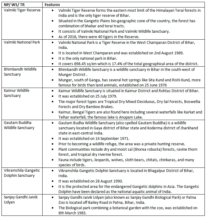
Bihar, one of India's most biodiverse states, features a rich variety of flora and fauna. The state is home to three national parks and 21 wildlife sanctuaries. Valmiki National Park, covering around 800 square kilometers in West Champaran near Nepal, is primarily made up of Shorea robusta, a type of damp sal-bearing forest.
Here are some key points about Bihar's forests:
- The total forest area in Bihar is 7,299 square kilometers, which constitutes 7.75% of the state's total area and 1.04% of India's forest cover.
- Sheikhpura has the smallest forest area in Bihar.
- Kaimur district has the largest forest area.
- The most extensive area of very dense forest is located in West Champaran.
- Dry Deciduous forests are predominantly found in Kaimur, Purnia, Raxaul, and other regions.
- Moist Deciduous forests are present in Kishanganj, West Champaran, Kaimur, and Gaya.
The important National Parks, Wildlife Sanctuaries and Tiger Reserves in the state of Bihar are:
Waterfalls and Hot Springs of Bihar
Some of the mains waterfalls and hotsprings of the state of Bihar are:

Soil in Bihar
In Bihar, a state with a significant agricultural sector, the soils are categorized based on their location and characteristics into North Bihar Plains and South Bihar Plains.
Here’s a summary of the different soil types found in Bihar:
- Soils of North Bihar:
- Piedmont Swamp Soil
- Terai Soil
- Recent Alluvium Soil- Khadar and Bhangar
- Soils of South Bihar:
- Old Alluvium Soil
- Tal Soil
- Balthar Soil
- Red Sandy Soil
Different types of soil found in Bihar are given below with some important feature of these: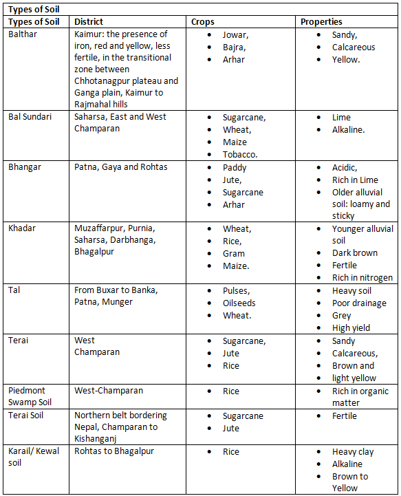
FAQs on Physiography of Bihar: Location and Geological Structure - BPSC (Bihar)
| 1. What is the physiography of Bihar in terms of its location and geological structure? |  |
| 2. How would you describe the geological structure of Bihar? |  |
| 3. What is the climate of Bihar like? |  |
| 4. How many seasons are there in Bihar? |  |
| 5. What is the significance of the flora and fauna of Bihar? |  |


