Rajasthan - Relief, Structure, and Geographical Location | RPSC Preparation: All subjects - RPSC RAS (Rajasthan) PDF Download
Aravalli Range
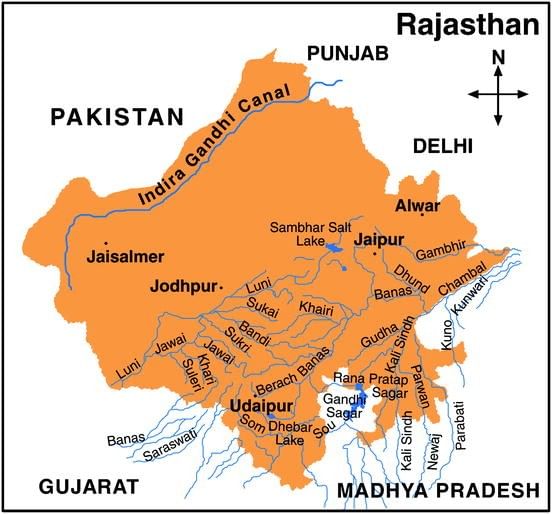
- The Aravalli Range is a prominent geographic feature in Rajasthan, stretching over 850 km from southwest Guru Peak (Mount Abu) to Khetri in the northeast.
- It divides Rajasthan into two distinct regions: the northwest comprising 60% of the state and the southeast comprising 40%.
- The northwest region is characterized by sandy, arid terrain with limited water resources. This area transitions from desert landscapes in the far western and northwestern parts to relatively more fertile and habitable lands towards the east.
- An important part of this region is the Great Indian Desert, also known as the Thar Desert.
- Mount Abu, situated at the southwestern edge of the Aravalli Range, stands at 1,722 meters in height. It is separated from the main ranges by the West Banas River.
- The Aravalli Range extends into Haryana towards Delhi, manifesting as outcrops such as Raisina Hill and ridges further north in India.
- Roughly three-fifths of Rajasthan lie to the northwest of the Aravallis, while the remaining two-fifths are situated to the east and south.
Physiographic Divisions of Rajasthan
On the basis of the existing relief features, Rajasthan is categorized into the following physiographic divisions:

Western Sandy Plains
The western region of Rajasthan consists of extensive sandy plains interrupted by rocky outcrops, extending towards the Pakistan border.
- Sandy Arid Plains: The sandy arid plains include Marusthali and regions devoid of sand dunes.
- Semi-Arid Transitional Plains (Rajasthan Bagar): This transitional zone comprises the Luni Basin, the Plain of Interior Drainage, and the Ghaggar Plain.
Approximately 63% of the sand dune area in Rajasthan is concentrated in the desert districts of Barmer, Jaisalmer, and Bikaner.
Aravalli Range and Hilly Region
The Aravalli range is the primary mountain range in Rajasthan, with a geological history dating back to the dharwar times. It extends diagonally across the state from northeast near Delhi to southwest towards the Plains of Gujarat, covering a distance of about 692 kilometers.
- Aravalli Range and Bhorat Plateau:
- This division encompasses East Sirohi, most of Udaipur except a small eastern belt, and the entire Durgarpur district.
- The highest part of the Aravalli range, known as the 'Bhorat' Plateau, is situated northwest of Udaipur between Kumbhalgarh and Gogunda, with an average elevation of 1,225 meters.
- Northeastern Hilly Region:
- Located at the northern edge of the Bhorat Plateau.
- Varied elevation ranging from 550m to 670m north of Kumbhalgarh.
Eastern Plains
Found northeast, east, and southeast of the Aravalli range. Bounded by the Vindhyan Plateau in the southeast and the eastern edge of the Aravalli up to north of Udaipur in the west.
- Banas Basin:
- Forms a watershed running eastwards from Udai Sagar, east of Udaipur.
- Acts as the southern boundary of the Mewar Plains, marking the Chappan Plain to the south.
- Characterized by various erosional features in granite and gneiss rocks.
- Chappan Plains:
- Lies south of the great Indian watershed in southeastern Udaipur, Banswara, and southern Chittorgarh district.
- Drained by Mahi River tributaries, this region is deeply eroded and features separate hillocks.
- Distinct from the Mewar Plain, this area is known for its intricate erosion and is locally referred to as 'Begaar'.
 |
Download the notes
Rajasthan - Relief, Structure, and Geographical Location
|
Download as PDF |
Southeastern Rajasthan Pathar (Hadoti Plateau)
The eastern region adjacent to the Chambal River is occupied by the Hadoti Plateau. Its northwest boundary is defined by the Great Boundary Fault of the Aravallis, which stretches eastward into the Rajasthan border. The Chambal River is responsible for draining a significant portion of this plateau.
The Plateau is divided into two distinct smaller sections:
- Vindhyan Scarpland:
- The Vindhyan Scarpland is a region within the Hadoti Plateau, characterized by south-southeast facing scarps situated between the Banas and Chambal rivers.
- These scarps extend eastward into Bundelkhand.
- Deccan Lava Plateau:
- The Deccan Lava Plateau, also known as the 'pathar' or 'uparmal' plateau, is a broad stony upland that includes the Kota-Bundi plateau section.
 |
Take a Practice Test
Test yourself on topics from RPSC RAS (Rajasthan) exam
|
Practice Now |
Rajasthan geographical Location
- Rajasthan, situated in the northwestern region of India, stands as the largest state in the country, covering a vast area of 3,42,239 square kilometers, which is approximately 11% of India's total geographical expanse.
- Comparing Rajasthan's size to that of Western nations like Italy, Norway, and Poland, it becomes evident how immense the state truly is.
- The state's geographical coordinates fall between latitudes 23 degrees 3 minutes to 30 degrees 12 minutes north and longitudes 69 degrees 30 minutes to 78 degrees 17 minutes east.
- Despite its location, Rajasthan experiences a relatively milder climate compared to countries located along similar latitudes, such as those in northern Arabia.
- Rajasthan's landscape, known for scorching summers and arid terrain, has been undergoing substantial transformations due to developmental initiatives, notably the expansion of the Indira Gandhi Nahar.
- Shaped like a rhomboid, Rajasthan stretches 869 kilometers from west to east and 826 kilometers from north to south.
- The state shares its borders with Pakistan, spanning approximately 1,070 kilometers and encompassing key districts like Barmer, Bikaner, Ganganagar, and Jaisalmer.
- With a total of 32 districts, Rajasthan boasts a diverse and expansive territory.
- Rajasthan is bordered by Haryana, Uttar Pradesh, and Punjab to the north and northeast, while Uttar Pradesh and Madhya Pradesh lie to the east. Gujarat is situated to the southwest of the state.
- Rajasthan's landscape is diverse, encompassing rolling sand dunes, fertile plains, rocky terrain, and some forested areas. The state is home to the vast Thar Desert, also known as the 'Maru-kantar', which is the largest desert in India.
- Only a small portion, about 9.36% of Rajasthan's total area, is covered by forest vegetation.
- Rajasthan's western region, predominantly barren, encompasses the Great Indian Thar Desert. In contrast, the southeastern area features rocky terrain that is considerably wetter and more fertile. This fertile region supports the cultivation of cotton, food grains, oilseeds, and sugarcane, which are significant to its agricultural output. Additionally, the western part includes some wooded areas and water bodies. Notably, the Sabhar region has rich salt deposits, and the Khetri and Dariba areas are known for their copper mines.
- The Aravalli Range is the principal geographical feature of Rajasthan, stretching over 850 km from Guru Peak (Mount Abu) in the southwest, with an elevation of 1,722 meters, to Khetri in the northeast. This range divides Rajasthan into roughly 60% in the northwest and 40% in the southeast. The northwest region is characterized by sandy, unproductive land with limited water, gradually transitioning from the desert conditions of the far west to more fertile and habitable land toward the eastern part of the state.
- Mount Abu, located at the southwestern end of the Aravalli Range, is separated from the main range by the West Banas River. The Aravallis continue into Haryana and appear as outcrops such as Raisina Hill north of Delhi. About three-fifths of Rajasthan lies northwest of the Aravallis, with the remaining two-fifths situated to the east and south.
- Rajasthan features a diverse topography across its regions. The southeastern area, with elevations ranging from 100 to 350 meters above sea level, is more fertile and varied in landscape. This region includes the hilly Mewar tract in the south, a tableland in the southeast encompassing parts of Kota and Bundi, and a rugged badlands area in the northeast along the Chambal River. To the north of these districts, the terrain levels out into the flat plains of the Bharatpur district, which are part of the Yamuna River's alluvial basin.
- In contrast, the northwestern plain of Rajasthan, extending across districts such as Jaisalmer, Barmer, Jalor, Sirohi, Jodhpur, Bikaner, Ganganagar, Jhunjhunu, Sikar, Pali, and Nagaur, is predominantly sandy and characterized by saline or alkaline soils. Water is scarce, typically found at depths of 30 to 61 meters, and the soil is calcareous. However, the introduction of the Indira Gandhi Canal has demonstrated that with sufficient water supplies, cultivation is feasible in these areas.
- Irrigation dams and deep wells are the primary sources of water for agriculture in Rajasthan. The state also features forested regions, including those in Alwar, Bharatpur, and Sawai Madhopur, where wildlife such as blue bulls, tigers, wild boars, panthers, and deer can be found. The fertile alluvial soil supports major crops like wheat, maize, paddy, and sugarcane, particularly in the Kota and Bundi areas, as well as in the Chittorgarh and Bhilwara districts.
|
152 videos|84 docs
|
FAQs on Rajasthan - Relief, Structure, and Geographical Location - RPSC Preparation: All subjects - RPSC RAS (Rajasthan)
| 1. What is the significance of the Aravalli Range in Rajasthan? |  |
| 2. How are the physiographic divisions of Rajasthan classified? | |
| 3. Where is Rajasthan geographically located in India? | |
| 4. What is the relief and structure of Rajasthan like? | |
| 5. How does the geographical location of Rajasthan impact its climate and economy? | |


Rajasthan - Relief
,Important questions
,Summary
,Semester Notes
,Structure
,Rajasthan - Relief
,Exam
,Viva Questions
,practice quizzes
,and Geographical Location | RPSC Preparation: All subjects - RPSC RAS (Rajasthan)
,ppt
,Previous Year Questions with Solutions
,MCQs
,and Geographical Location | RPSC Preparation: All subjects - RPSC RAS (Rajasthan)
,Sample Paper
,shortcuts and tricks
,past year papers
,Structure
,mock tests for examination
,Objective type Questions
,study material
,Extra Questions
,Structure
,and Geographical Location | RPSC Preparation: All subjects - RPSC RAS (Rajasthan)
,Rajasthan - Relief
,Free
,video lectures
;


Rajasthan - Relief, Structure, and Geographical Location Free PDF Download
Importance of Rajasthan - Relief, Structure, and Geographical Location
Rajasthan - Relief, Structure, and Geographical Location Notes
Rajasthan - Relief, Structure, and Geographical Location RPSC RAS (Rajasthan) Questions
Study Rajasthan - Relief, Structure, and Geographical Location on the App
|
© EduRev
|
Education Revolution
|


|


