RPSC RAS (Rajasthan) Exam > RPSC RAS (Rajasthan) Notes > RPSC Preparation: All subjects > Rajasthan - Rivers and Drainage System
Rajasthan - Rivers and Drainage System | RPSC Preparation: All subjects - RPSC RAS (Rajasthan) PDF Download
Rajasthan's Drainage System
- Rajasthan is the largest state in India by area, with 5.5% of the population but only 1% of the country's water resources. The state is divided into 13 watersheds and 59 sub-watersheds. Most rivers originate from the Aravali hills and flow either east or west. Rivers flowing east join the Yamuna, while those flowing west either merge into the Gulf of Khambhat or are lost in the desert.
- The Thar Desert covers a large portion of the western part of the state, resulting in very few rivers in this region. The Aravali Range serves as a water divider, splitting Rajasthan's river system into two parts.
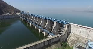
- Chambal and Luni are the primary rivers in Rajasthan. Chambal is the state's only perennial river, originating from the northern slopes of the Vindhya Range at Chaurasigarh and flowing along the eastern border between Rajasthan and Madhya Pradesh. It flows northwards across the state, fed by its tributaries, and eventually joins the Yamuna River.
- Luni, another major river in Rajasthan, starts from the Aravali Range, 7 kilometers north of Ajmer. It is the only river that traverses the western part of the state, flowing into Gujarat and draining into the Rann of Kutch. Luni is a seasonal river and is relatively shallow compared to other state rivers. It is also supported by several tributaries originating from the Aravali Range.
- Rajasthan is home to several rivers, many of which are seasonal. Ghaggar is an intermittent stream that flows through the state but vanishes in the Thar Desert. Other notable rivers in Rajasthan include Kali, Banas, Banganga, Parvati, Gambhiri, Mahi, Kakni, Jokham, Sabarmati, Katli, Sabi, and Mantha.
- Smaller streams and their tributaries drain the west and south of the Aravalli Range, with significant rivers being Luni, Sukri, Banas, Sabarmati, and Mahi. These streams are generally non-perennial. On the eastern side of the watershed, the Chambal River is joined by the Banas River and its tributaries: Khari, Moshi, and Morel on the left bank, and Berach, Bajasen, and Golwa on the right bank. The Chambal River ultimately flows into the Yamuna River in Uttar Pradesh.
- The inland drainage system is a distinctive feature of Rajasthan's drainage network, covering about 2% of the state's area, primarily west of the Aravalli Range. This region includes several separate drainage basins such as the Kanti, Sota, Sahibi, and Barah basins of the Luni Basin. The desert area in the west absorbs most of the water from these rivers.
- The Luni River, originating at Ana Sagar near Ajmer, is the only major watercourse in this region. It flows southwest for approximately 32 km through the semi-arid districts of Jodhpur, Barmer, and Jalor, west of the Aravalli Range. The river has a small catchment area of about 32 square kilometers at its source near Talod Road. As it progresses, it receives a small tributary from the Pushkar Valley, causing the basin to widen. Near Ajmer, the river descends from the Aravalli slopes and continues southwest.
- The Luni drains a total catchment area of about 34,866.40 square kilometers and is fed by several smaller hill torrents from the western slopes of the Aravalli Range, including Lalri, Ghuhia, Bandi, Sukri, Jawai, Jojri, and Sagai, all joining from the left bank. Up to Balotra, the river carries water, but it becomes increasingly saline downstream until it reaches the Rann of Kutch. In Jodhpur District, the river widens rather than deepens, as floods quickly develop due to the nature of rainfall, preventing the river from eroding its bed. During the rainy season, the Luni River sometimes overflows and damages the railway line that runs parallel to it from Luni Junction to Gole.
- The southern and eastern regions of Rajasthan, specifically south, southeast, and east of the Aravalli Range, receive over 80 cm of rainfall and feature some significant streams. Among these, the Chambal River is the largest, accompanied by tributaries such as the Banas, Kali Sindh, and Parbati. The Chambal River is perennial, but its tributaries may occasionally dry up and reveal their stony beds. Originating from the northern slopes of the Vindhyan scarps near Manpur (884.4 m) south of Mhow, the Chambal River travels approximately 325 km through a steep, narrow gorge with valley walls rising 60 to 90 meters above the valley floor.
- The river descends to 505 m near Chaurasigarh and continues to Kota. Its first major tributary, the Kali Sindh, joins near Monera village, followed by the Parbati about 48 km downstream. The Chambal River flows straight for about 212 km before bending southeast at Pinahat and eventually merging with the Yamuna River near Muradganj, covering a total distance of approximately 965 km. In Rajasthan, the river flows for about 153 km and forms the boundary between Rajasthan and Madhya Pradesh from Palia to Pinahat, a stretch of 241 km. It then serves as the boundary between Madhya Pradesh and Uttar Pradesh before joining the Yamuna River in Uttar Pradesh. In Rajasthan, the Kurai and Banas tributaries join the Chambal River from the left bank.
- The Banas River traverses the central region of the Mewar Plains, with its major tributaries including the Berach, Kothari, Khari, Dhoond, and Morel rivers. Originating from the area between Kankroli and Nathdwara, the Banas River flows eastward to Mandalgarh. It then shifts its course northeastward to Tonk before turning east again and eventually making a right-angle turn southward to join the Chambal River. The river's upper reaches, characterized by hilly terrain, receive substantial rainfall.
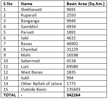
River Basin Areas in Rajasthan State

Other Rivers Originating in Rajasthan
- Banganga River: Starts from Bairath in the Jaipur district, travels through Ramgarh, Dausa, and Baswa for approximately 164 km, and eventually flows into Vair tehsil of Bharatpur and Agra district in Uttar Pradesh.
- Sukel River: Begins in the hills of Jalor and flows into the Rann of Kutch.
- Jakham River: Originates from Chhoti Sadri in the Chittorgarh district of Rajasthan.
- Som River: Starts at Bichhawara (Jhadol) in the Udaipur district of Rajasthan.
- Kantli River: Comes from the Khandela hills in the Sikar district of Rajasthan.
- Kakney River: Originates in the Kotri hills of Jaisalmer district, Rajasthan.
- Kothari River: Emerges from Dewas (Jhadol) in the Udaipur district of Rajasthan.
- Sabarmati River: Begins at Padrara (Gogunda) hills in the Udaipur district of Rajasthan.
Question for Rajasthan - Rivers and Drainage System
Try yourself:
Which river in Rajasthan is the only perennial river and eventually joins the Yamuna River?View Solution
Lakes of Rajasthan: Types of Lakes
 |
Download the notes
Rajasthan - Rivers and Drainage System
|
Download as PDF |
Download as PDF
Saline Water Lakes
- Sambhar Lake
- Location: Border of Jaipur and Nagaur districts
- Dimensions: Length 32 km; Breadth 3 km to 12 km
- Area: 234 sq. km
- Details: Rajasthan's largest lake; produces 35 crore tons of common salt annually using solar evaporation from March to July.
- Deedwana Lake
- Location: Near Deedwana Town, Nagaur district
- Dimensions: Length 4 km; Breadth 2 km
- Details: Surrounded by sand dunes and isolated Aravalli spur; features block clay at the bed.
- Pachpadra Lake
- Location: Near Pachpadra, Barmer district
- Area: 25 sq. km
- Details: Salt pits cover 5000 sq. m; the salt produced is similar to sea salt.
- Lunkaransar Lake
- Location: Near Lunkaransar Town, Bikaner district
- Area: 6 sq. km
- Details: Mainly produces sodium chloride (NaCl).
 |
Take a Practice Test
Test yourself on topics from RPSC RAS (Rajasthan) exam
|
Practice Now |
Practice Now
Sweet Water Lakes
- Jaisamand Lake
- Built By: Maharana Jai Singh, 1691
- Location: Udaipur
- Dimensions: Breadth 1 km to 8 km; Circumference 50 km
- Details: Largest freshwater lake in Rajasthan; features seven islands inhabited by Bhils. Includes two irrigation canals (Shyampura and Bhat).
- Rajsamand Lake
- Built By: Maharaja Raj Singh, 1662
- Dimensions: Length 6.5 km; Breadth 3 km
- Location: Rajsamand district
- Details: Used for irrigation; fed by Banas feeder canals. Notable for a large literary inscription on stone.
- Pichhola Lake
- Built By: Banjara in the 15th century; Renovated by Maharaja Udai Singh in early 20th century
- Dimensions: Length 7 km; Breadth 2 km
- Location: Near Udaipur
- Details: Includes Fateh Sagar and Swaroop Sagar; a prominent lake in the city.
- Fateh Sagar Lake
- Location: North of Pichhola Lake
- Area: 3 sq. km
- Details: Artificial lake with a public park and fountain on a small island.
- Udai Sagar Lake
- Built By: Maharana Udai Singh, 1559-1565
- Location: 15 km east of Udaipur
- Dimensions: Length 4 km; Breadth 3 km
- Details: Site of a historical meeting between Maharana Pratap and Kunwar Man Singh.
- Ana Sagar Lake
- Built By: Ana Ji, Lord of Ajmer, 1137
- Location: Ajmer city
- Details: Features Daulat Bagh and a 378 m log ‘Baradari’ built by Shah Jahan for scenic views.
- Nakki Lake
- Location: Near Mount Abu
- Area: 9 sq. km
- Depth: 35 m
- Details: A small natural lake.
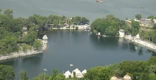
- Pushkar Lake
- Location: 11 km west of Ajmer City
- Area: 3 sq. km
- Details: Irregular elliptical shape; considered holy by Hindus. Surrounded by temples and bathing ghats.
- Siliserh Lake
- Location: 12 km west of Alwar City
- Area: 10 sq. km
- Details: Small natural lake, surrounded by low hills. Includes an early 20th-century canal irrigation system built by King Jai Singh.
- Kolayat Lake
- Location: Near Kolayat Town, about 48 km southwest of Bikaner City
- Details: Famous for Kapil Muni Ashram; hosts an annual fair on Kartik Purnima.
- Balsamand Lake
- Location: About 6 km from Jodhpur City
- Details: Large artificial lake with a small palace and pavilions on its banks, near Mandore Gardens.
The document Rajasthan - Rivers and Drainage System | RPSC Preparation: All subjects - RPSC RAS (Rajasthan) is a part of the RPSC RAS (Rajasthan) Course RPSC Preparation: All subjects.
All you need of RPSC RAS (Rajasthan) at this link: RPSC RAS (Rajasthan)
|
152 videos|84 docs
|
FAQs on Rajasthan - Rivers and Drainage System - RPSC Preparation: All subjects - RPSC RAS (Rajasthan)
| 1. What are the major rivers in Rajasthan? |  |
| 2. Can you provide an overview of the River Luni in Rajasthan? | |
Ans. The River Luni is the only significant river in Rajasthan that flows entirely within the state. It originates in the Aravalli Range and flows through the western part of Rajasthan before entering Gujarat.
| 3. Which other rivers have their origin in Rajasthan? | |
Ans. Other rivers that have their origin in Rajasthan include the Betwa, Parvati, and Kali Sindh.
| 4. What are the key lakes in Rajasthan? | |
Ans. Some key lakes in Rajasthan include Lake Pichola, Ana Sagar Lake, and Fateh Sagar Lake.
| 5. What is the drainage system of Rajasthan like? | |
Ans. The drainage system of Rajasthan is primarily dominated by the inland drainage pattern, with most of the rivers draining into salt lakes or disappearing into the desert sands.
Related Exams
About this Document

Mar 27, 2025
Last updated
Document Description: Rajasthan - Rivers and Drainage System for RPSC RAS (Rajasthan) 2025 is part of RPSC Preparation: All subjects preparation.
The notes and questions for Rajasthan - Rivers and Drainage System have been prepared according to the RPSC RAS (Rajasthan) exam syllabus. Information about Rajasthan - Rivers and Drainage System covers topics
like Rajasthan's Drainage System, River Basin Areas in Rajasthan State, Lakes of Rajasthan: Types of Lakes and Rajasthan - Rivers and Drainage System Example, for RPSC RAS (Rajasthan) 2025 Exam. Find important definitions, questions, notes, meanings, examples, exercises and tests below for Rajasthan - Rivers and Drainage System.
Introduction of Rajasthan - Rivers and Drainage System in English is available as part of our RPSC Preparation: All subjects
for RPSC RAS (Rajasthan) & Rajasthan - Rivers and Drainage System in Hindi for RPSC Preparation: All subjects course.
Download more important topics related with notes, lectures and mock test series for RPSC RAS (Rajasthan)
Exam by signing up for free. RPSC RAS (Rajasthan): Rajasthan - Rivers and Drainage System | RPSC Preparation: All subjects - RPSC RAS (Rajasthan)
Description
Full syllabus notes, lecture & questions for Rajasthan - Rivers and Drainage System | RPSC Preparation: All subjects - RPSC RAS (Rajasthan) - RPSC RAS (Rajasthan) | Plus excerises question with solution to help you revise complete syllabus for RPSC Preparation: All subjects | Best notes, free PDF download
Information about Rajasthan - Rivers and Drainage System
In this doc you can find the meaning of Rajasthan - Rivers and Drainage System defined & explained in the simplest way possible. Besides explaining types of
Rajasthan - Rivers and Drainage System theory, EduRev gives you an ample number of questions to practice Rajasthan - Rivers and Drainage System tests, examples and also practice RPSC RAS (Rajasthan)
tests
Related Searches
shortcuts and tricks
,video lectures
,past year papers
,Important questions
,Viva Questions
,Free
,Semester Notes
,mock tests for examination
,Summary
,Exam
,Objective type Questions
,MCQs
,ppt
,Rajasthan - Rivers and Drainage System | RPSC Preparation: All subjects - RPSC RAS (Rajasthan)
,Sample Paper
,Rajasthan - Rivers and Drainage System | RPSC Preparation: All subjects - RPSC RAS (Rajasthan)
,Rajasthan - Rivers and Drainage System | RPSC Preparation: All subjects - RPSC RAS (Rajasthan)
,study material
,Previous Year Questions with Solutions
,Extra Questions
,practice quizzes
;


Additional Information about Rajasthan - Rivers and Drainage System for RPSC RAS (Rajasthan) Preparation
Rajasthan - Rivers and Drainage System Free PDF Download
The Rajasthan - Rivers and Drainage System is an invaluable resource that delves deep into the core of the RPSC RAS (Rajasthan) exam.
These study notes are curated by experts and cover all the essential topics and concepts, making your preparation more efficient and effective.
With the help of these notes, you can grasp complex subjects quickly, revise important points easily,
and reinforce your understanding of key concepts. The study notes are presented in a concise and easy-to-understand manner,
allowing you to optimize your learning process. Whether you're looking for best-recommended books, sample papers, study material,
or toppers' notes, this PDF has got you covered. Download the Rajasthan - Rivers and Drainage System now and kickstart your journey towards success in the RPSC RAS (Rajasthan) exam.
Importance of Rajasthan - Rivers and Drainage System
The importance of Rajasthan - Rivers and Drainage System cannot be overstated, especially for RPSC RAS (Rajasthan) aspirants.
This document holds the key to success in the RPSC RAS (Rajasthan) exam.
It offers a detailed understanding of the concept, providing invaluable insights into the topic.
By knowing the concepts well in advance, students can plan their preparation effectively.
Utilize this indispensable guide for a well-rounded preparation and achieve your desired results.
Rajasthan - Rivers and Drainage System Notes
Rajasthan - Rivers and Drainage System Notes offer in-depth insights into the specific topic to help you master it with ease.
This comprehensive document covers all aspects related to Rajasthan - Rivers and Drainage System.
It includes detailed information about the exam syllabus, recommended books, and study materials for a well-rounded preparation.
Practice papers and question papers enable you to assess your progress effectively.
Additionally, the paper analysis provides valuable tips for tackling the exam strategically.
Access to Toppers' notes gives you an edge in understanding complex concepts.
Whether you're a beginner or aiming for advanced proficiency, Rajasthan - Rivers and Drainage System Notes on EduRev are your ultimate resource for success.
Rajasthan - Rivers and Drainage System RPSC RAS (Rajasthan) Questions
The "Rajasthan - Rivers and Drainage System RPSC RAS (Rajasthan) Questions" guide is a valuable resource for all aspiring students preparing for the
RPSC RAS (Rajasthan) exam. It focuses on providing a wide range of practice questions to help students gauge
their understanding of the exam topics. These questions cover the entire syllabus, ensuring comprehensive preparation.
The guide includes previous years' question papers for students to familiarize themselves with the exam's format and difficulty level.
Additionally, it offers subject-specific question banks, allowing students to focus on weak areas and improve their performance.
Study Rajasthan - Rivers and Drainage System on the App
Students of RPSC RAS (Rajasthan) can study Rajasthan - Rivers and Drainage System alongwith tests & analysis from the EduRev app,
which will help them while preparing for their exam. Apart from the Rajasthan - Rivers and Drainage System,
students can also utilize the EduRev App for other study materials such as previous year question papers, syllabus, important questions, etc.
The EduRev App will make your learning easier as you can access it from anywhere you want.
The content of Rajasthan - Rivers and Drainage System is prepared as per the latest RPSC RAS (Rajasthan) syllabus.
|
© EduRev
|
Education Revolution
|


|


Signup on EduRev and stay on top of your study goals
10M+ students crushing their study goals daily