Unit Test (solutions): India - Size And Location | Social Studies (SST) Class 9 PDF Download

Time: 1 hour
M.M. 30
Attempt all questions.
- Question numbers 1 to 5 carry 1 mark each.
- Question numbers 6 to 8 carry 2 marks each.
- Question numbers 9 to 11 carry 3 marks each.
- Question numbers 12 & 13 carry 5 marks each.
Q1: Which of the following countries does not share a land boundary with India?
(i) Bhutan
(ii) Tajikistan
(iii) Bangladesh
(iv) Nepal
Ans: (ii) Tajikistan
India shares land boundaries with countries like Bhutan, Bangladesh, and Nepal. Tajikistan, although close, does not share a direct land boundary with India.
Q2: The Tropic of Cancer does not pass through which of the following states?
(i) Rajasthan
(ii) Odisha
(iii) Chhattisgarh
(iv) Tripura
Ans: (ii) Odisha
The Tropic of Cancer passes through Rajasthan, Chhattisgarh, and Tripura but not through Odisha.
Q3: The easternmost longitude of India is __________.
Ans: 97° 25' E
The easternmost point of India is located at 97° 25' E longitude in Arunachal Pradesh.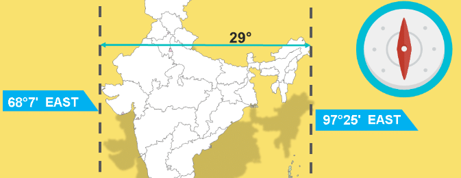
Q4: The southernmost point of the Indian Union, 'Indira Point', is _____________.
Ans: Andaman and Nicobar Islands
'Indira Point' is the southernmost point of the Indian Union and is located in the Nicobar Islands, which are part of the Andaman and Nicobar Islands group. 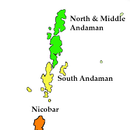
Q5: Which of the following is the correct length of the Indian coastline, including the Andaman and Nicobar, and Lakshadweep islands?
(i) 6,100 km
(ii) 7,516.6 km
(iii) 8,500 km
(iv) 5,400 km
Ans: (ii) 7,516.6 km
India’s total coastline, including the mainland and the islands of Andaman, Nicobar, and Lakshadweep, is approximately 7,516.6 km long.
Q6: Why does India have a central location between East and West Asia? Explain its significance.
Ans: India occupies a central location between East and West Asia because of its southward extension into the Indian Ocean. This strategic location enables India to connect easily with countries in West Asia, Africa, and Europe from the western coast, and Southeast and East Asia from the eastern coast.
This central location is significant as it facilitates trade routes and cultural exchanges between these regions, enhancing India's influence in the Indian Ocean.
Q7: How does the latitudinal extent of India influence the duration of day and night?
Ans: i) The latitudinal extent of India, which ranges from 8°4'N to 37°6'N, affects the duration of day and night across the country. As one moves from south to north, the difference in the duration of day and night becomes more noticeable.
ii) For example, in the southernmost region like Kanniyakumari, the difference is minimal, while in northern regions like Kashmir, there is a significant variation, especially between summer and winter.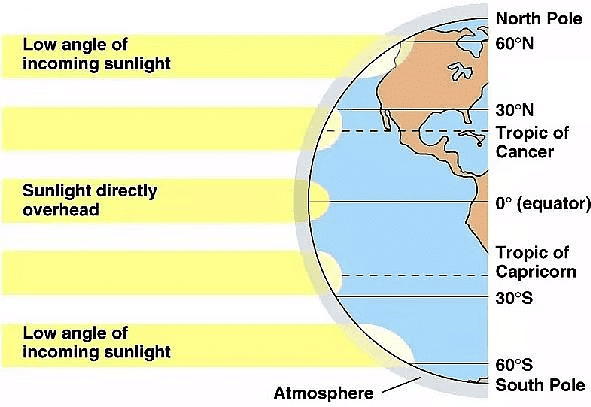
Q8: Explain why there is a time difference of two hours between Gujarat and Arunachal Pradesh, yet the watches show the same time.
Ans: i) The time difference of two hours between Gujarat (in the west) and Arunachal Pradesh (in the east) is due to the longitudinal extent of India. The earth rotates 1° longitude every 4 minutes, and with India's east-west extent of about 30°, this results in a two-hour difference. ii) However, the entire country follows a single time zone based on the Standard Meridian of India (82°30'E), which passes through Mirzapur, to maintain uniformity across the nation.
Q9: Discuss the significance of the Standard Meridian of India (82°30'E).
Ans: i) Central Location: The Standard Meridian (82°30'E) is centrally located, allowing for a balanced time standard across India, reducing the difference in local times from the eastern to western regions.
ii) Consistency in Time: It helps maintain uniformity in time across the country despite the wide longitudinal spread, ensuring synchronization in activities like transport, communication, and broadcasting.
iii) Coordination with Neighboring Countries: The use of a standard meridian close to India’s central longitude helps coordinate with neighboring countries’ time zones, facilitating smoother cross-border interactions.
iv) Impact on Daily Life: The Standard Meridian influences daily activities by providing a common reference for time, which is crucial for scheduling work, school hours, and transportation across the country.
Q10: How does the location of India contribute to its importance in the Indian Ocean region?
Ans: i) Strategic Positioning: India’s peninsular extension into the Indian Ocean gives it control over vital sea lanes used for global trade, making it a pivotal player in the region.
ii) Maritime Security: The extensive coastline and naval bases along the Indian Ocean enhance India's capability to secure trade routes and ensure maritime security.
iii) Facilitates Trade: India's location allows for efficient trade connections between East Asia, Southeast Asia, the Middle East, and Europe, bolstering its economy and strategic influence.
iv) Cultural Exchanges: Historically, India’s position in the Indian Ocean facilitated cultural exchanges and the spread of Indian culture, religion, and goods to various parts of Asia and Africa.
Q11: Differentiate between India’s land and maritime boundaries, including their lengths and significance.
Ans: 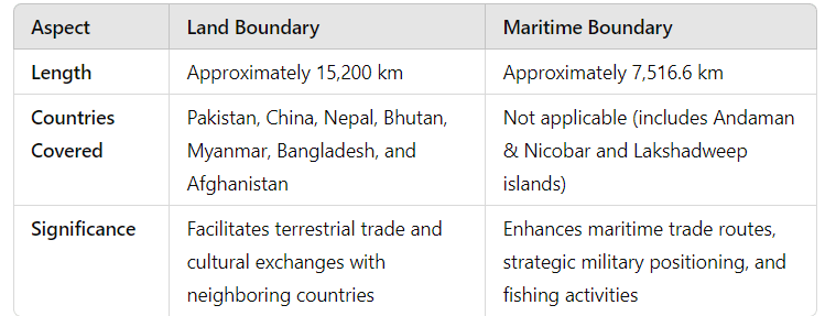
India's land boundary connects it to neighboring countries, influencing its bilateral relations, while the maritime boundary boosts its naval capabilities and trade routes through the Indian Ocean.
Q12: Discuss the relationship between India and its neighboring countries, focusing on geographical and historical aspects.
Ans: a) Geographical Proximity:
i) India shares land boundaries with seven countries: Pakistan, China, Nepal, Bhutan, Myanmar, Bangladesh, and Afghanistan.
ii) Maritime boundaries are shared with Sri Lanka and Maldives, separated by narrow seas.
b) Historical Ties:
i) Religious and Cultural Exchanges: Buddhism spread from India to neighboring countries like Nepal, Bhutan, and Sri Lanka.
ii) Colonial History: The partition of India in 1947 created significant historical and political links with Pakistan and Bangladesh.
c) Economic Interactions:
i) Cross-border trade and connectivity projects like the Bangladesh-Bhutan-India-Nepal (BBIN) initiative have been established.
ii) The Indian Ocean serves as a key route for trade with Sri Lanka, Maldives, and other maritime neighbors.
d) Security Concerns:
i) India’s relationships are influenced by border disputes (e.g., with China and Pakistan) and the need for regional stability.
ii) Collaborative efforts in disaster management and climate change with island nations like Maldives and Sri Lanka.
e) Diplomatic Relations: India actively engages in diplomatic initiatives with its neighbors, such as the South Asian Association for Regional Cooperation (SAARC), to foster regional cooperation and address common challenges.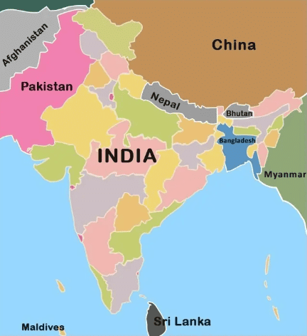 Neighboring countries of India
Q13: Analyze how India’s location has influenced its cultural and economic exchanges with the rest of the world since ancient times.
Ans: i) Ancient Trade Routes:
a) Land Routes: The northern passes allowed for the movement of goods, ideas, and people, facilitating the spread of Indian culture and religion (Buddhism and Hinduism) to Central Asia and China.
b) Maritime Routes: India’s coastal location enabled it to engage in extensive maritime trade with East Africa, Southeast Asia, and Europe.
ii) Cultural Exchanges:
a) Indian architecture, languages, and religious practices were influenced by interactions with Persian, Greek, Arab, and European civilizations.
b) The exchange of spices, textiles, and the Indian numeral system impacted global culture and economics.
iii) Colonial Impact:
a) The strategic location attracted European powers, leading to colonization and the integration of India into global trade networks.
b) The opening of the Suez Canal in 1869 reduced travel distance between India and Europe, enhancing trade.
iv) Modern Significance:
a) India's location continues to make it a central player in global shipping routes, enhancing its economic and strategic importance in the Indian Ocean region.
b) India's central position aids in diplomatic relations and regional cooperation in South Asia and beyond.
v) Global Influence: India’s strategic location has allowed it to influence global maritime policies and participate actively in international organizations like the Indian Ocean Rim Association (IORA), promoting regional economic cooperation and security.
|
55 videos|525 docs|78 tests
|
FAQs on Unit Test (solutions): India - Size And Location - Social Studies (SST) Class 9
| 1. भारत का भौगोलिक क्षेत्रफल कितना है? |  |
| 2. भारत की सीमाएँ किन देशों से लगती हैं? | |
| 3. भारत का कुल coastline (तटरेखा) कितना है? | |
| 4. भारत का स्थानिक स्थिति (latitudinal and longitudinal) क्या है? | |
| 5. भारत की जलवायु पर इसके आकार का क्या प्रभाव पड़ता है? | |


Free
,mock tests for examination
,Extra Questions
,Unit Test (solutions): India - Size And Location | Social Studies (SST) Class 9
,MCQs
,past year papers
,Important questions
,video lectures
,Previous Year Questions with Solutions
,Exam
,practice quizzes
,Objective type Questions
,Unit Test (solutions): India - Size And Location | Social Studies (SST) Class 9
,Unit Test (solutions): India - Size And Location | Social Studies (SST) Class 9
,study material
,Sample Paper
,Viva Questions
,Summary
,ppt
,shortcuts and tricks
,Semester Notes
;


Unit Test (solutions): India - Size And Location Free PDF Download
Importance of Unit Test (solutions): India - Size And Location
Unit Test (solutions): India - Size And Location Notes
Unit Test (solutions): India - Size And Location Class 9 Questions
Study Unit Test (solutions): India - Size And Location on the App
|
© EduRev
|
Education Revolution
|


|


within 7 days!