Unit Test (Solutions): Locating Places on the Earth | Social Studies for Class 6 PDF Download

Time: 1 hour
M.M: 30
Attempt all questions.
Question numbers 1 to 5 carry 1 mark each.
Question numbers 6 to 8 carry 2 marks each.
Question numbers 9 to 11 carry 3 marks each.
Question numbers 12 & 13 carry 5 marks each.
Q1: What is the name of the imaginary line that divides the Earth into the Northern and Southern Hemispheres? (1 Mark)
Ans: The Equator.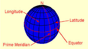
Q2: Which of the following is the correct description of latitude? (1 Mark)
(i) Distance measured in degrees east or west of the Prime Meridian.
(ii) Distance measured in degrees north or south of the Equator.
(iii) Imaginary line that circles the Earth from pole to pole.
(iv) None of these.
Ans: (ii)
Distance measured in degrees north or south of the Equator is the correct description of Latitude.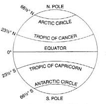
Q3: Fill in the blank: The _____ is the 0-degree longitude line that passes through Greenwich, England. (1 Mark)
Ans: Prime Meridian.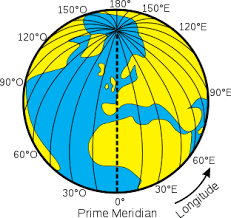
Q4: Which tool helps in locating places on the Earth using latitude and longitude? (1 Mark)
(i) Map
(ii) Globe
(iii) GPS
(iv) Compass
Ans: (iii)
GPS helps in locating places on the Earth using latitude and longitude.
Q5: The North Pole is at how many degrees latitude? (1 Mark)
Ans: 90° North Latitude.
Q6: Explain what longitudes are and how they are used to determine time.(2 Marks)
Ans: Longitudes are imaginary vertical lines that run from the North Pole to the South Pole. They are used to determine time zones as the Earth rotates 15 degrees of longitude every hour, which corresponds to a time difference of one hour between time zones
Q7: What are the different kinds of maps? Describe each briefly. (2 Marks)
Ans:
- Physical Maps: These maps primarily show natural features such as mountains, rivers, and oceans. For example, Fig. 5.2 in the textbook shows a physical map.
- Political Maps: These maps display boundaries, countries, states, cities, etc. An example would be a map of India showing all its states, union territories, and capitals.
- Thematic Maps: These maps are designed to convey specific kinds of information, such as population distribution or climate patterns. Examples include Fig. 6.3 and Fig. 8.1 in the textbook.
Q8: Define the term 'grid' as used in locating places on the Earth.(2 Marks)
Ans: A grid is a network of intersecting lines of latitude and longitude that form a pattern on the Earth's surface. This system helps in pinpointing exact locations by using coordinates.
Q9: Describe the importance of latitude and longitude in navigation and map-making. (3 Marks)
Ans:
- Latitudes and longitudes create a coordinate system that helps in locating places accurately on a map.
- Navigators and geographers use these coordinates to find specific places, especially when using maps or GPS systems.
- Latitude lines help determine climate zones, as they indicate how far a location is from the Equator.
- Longitude lines are crucial for determining time zones, as they divide the Earth into 24 zones.
- Together, latitude and longitude provide a global grid that is essential for map-making and understanding the Earth's geography.
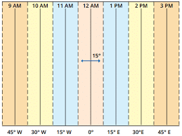
Q10: How does the Prime Meridian help in time calculation? (3 Marks)
Ans:
- The Prime Meridian (0° longitude) is the starting point for time zones.
- The Earth is divided into 24 time zones, each 15° of longitude wide.
- As we move east of the Prime Meridian, time increases by 1 hour for every 15°; as we move west, time decreases by 1 hour for every 15°.
- The Prime Meridian passes through Greenwich, and the time at this meridian is known as Greenwich Mean Time (GMT).
- Every country sets its standard time based on its position relative to the Prime Meridian, and international timekeeping is based on it.
Q11: Why is there a time difference between India and London, and why is it 5:30 pm in India when it is 12 pm (noon) in London? (3 Marks)
Ans:
- The Earth is divided into 24 time zones, each 15 degrees of longitude apart, based on its rotation.
- India is located to the east of the Prime Meridian at 82.5° East longitude, which is 5 hours and 30 minutes ahead of Greenwich Mean Time (GMT) in London.
- When it is 12 pm (noon) in London, the time in India is 5:30 pm because India follows Indian Standard Time (IST), which is GMT +5:30.
Q12: Explain the important components of maps.(5 Marks)
Ans:
- Distance: The scale of a map helps in understanding the distance between places. This scale converts real-world distances to a manageable size on paper.
- Direction: Cardinal directions (North, East, South, West) and intermediate directions (Northeast, Southeast, Southwest, Northwest) are used to show orientation on maps.
- Symbols: Symbols represent features like roads, buildings, rivers, and other elements in a simplified manner. This makes it easier to show many details in a small space.
- Cardinal Points: Maps often have an arrow marked with ‘N’ to indicate the north direction, helping users orient the map correctly.
- Intermediate Directions: In addition to the four cardinal points, intermediate directions like NE, SE, SW, and NW provide a more precise location on the map.
Q13: State the main differences between latitude and longitude. (5 Marks)
Ans:
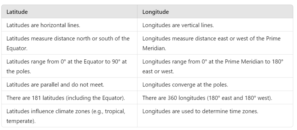
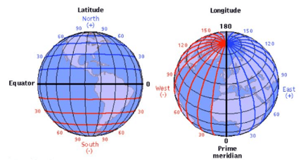
|
46 videos|241 docs|28 tests
|
FAQs on Unit Test (Solutions): Locating Places on the Earth - Social Studies for Class 6
| 1. What are the different methods for locating places on Earth? |  |
| 2. How do hobbies relate to exploring and locating places on Earth? | |
| 3. What tools can assist in locating places for travel or exploration? | |
| 4. How can I improve my navigation skills to locate places more effectively? | |
| 5. What role do coordinates play in locating places on Earth? | |


Unit Test (Solutions): Locating Places on the Earth | Social Studies for Class 6
,practice quizzes
,shortcuts and tricks
,video lectures
,Sample Paper
,Unit Test (Solutions): Locating Places on the Earth | Social Studies for Class 6
,Objective type Questions
,Unit Test (Solutions): Locating Places on the Earth | Social Studies for Class 6
,past year papers
,Viva Questions
,MCQs
,Important questions
,Semester Notes
,mock tests for examination
,ppt
,Previous Year Questions with Solutions
,study material
,Free
,Summary
,Extra Questions
,Exam
;


Unit Test (Solutions): Locating Places on the Earth Free PDF Download
Importance of Unit Test (Solutions): Locating Places on the Earth
Unit Test (Solutions): Locating Places on the Earth Notes
Unit Test (Solutions): Locating Places on the Earth Class 6 Questions
Study Unit Test (Solutions): Locating Places on the Earth on the App
|
© EduRev
|
Education Revolution
|


|


