Geography: December 2024 UPSC Current Affairs | Current Affairs & Hindu Analysis: Daily, Weekly & Monthly PDF Download
International Mountain Day 2024
Why in News?
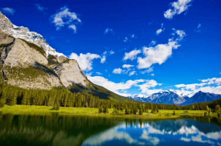
Recently, the Ministry of Environment, Forest and Climate Change observed International Mountain Day on 11 December to highlight the need to protect the Indian Himalayan Region (IHR).
Key Takeaways
- International Mountain Day is celebrated on December 11, established by the United Nations in 2003.
- The theme for 2024 is "Mountain solutions for a sustainable future – innovation, adaptation and youth."
- Mountains cover about one-fifth of the Earth's surface and are crucial for freshwater and biodiversity.
Additional Details
- Importance of Mountains: Mountains are vital as they provide essential freshwater for half of humanity and are home to 15% of the world's population.
- Indian Himalayan Region (IHR): The IHR spans across 13 Indian states and Union Territories, covering approximately 16.2% of India's geographical area.
- Concerns: Unsustainable development practices, climate change impacts, cultural erosion, and rising tourism threaten the fragile ecology of the region.
The preservation of mountain ecosystems is key to sustainable development and requires immediate action to mitigate the effects of climate change and other human activities.
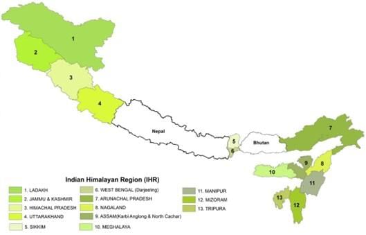
What Can Be Done to Protect the Indian Himalayan Region?
- Sustainable Tourism: Promote eco-tourism and enforce carrying capacity limits.
- Glacial Water Capture: Implement methods to store glacial meltwater for agriculture and ecosystems.
- Disaster Preparedness: Develop disaster management plans focusing on landslides and glacial lake outburst floods.
- Greywater Recycling: Set up systems to recycle household greywater for agricultural use.
- Bio-Cultural Conservation Zones: Designate areas to preserve natural biodiversity and indigenous practices.
- Integrated Development: Establish a "Himalayan Authority" for coordinated development across the region.
How are Mountains Formed?
Mountains are formed by movement within the Earth's crust, which consists of tectonic plates floating on molten magma. These plates shift and collide over time, creating pressure that causes the Earth's surface to buckle or protrude, forming mountains.
Key Characteristics of Mountains
- Elevation: Generally higher than surrounding land, often exceeding 600 meters.
- Steep Slopes: Typically have steep slopes, although some may be more gradual.
- Summit/Peak: The highest point of a mountain.
- Mountain Range: A series of connected mountains forming a range.
Types of Mountains
Based on Mode of Origin
- Volcanic Mountains: Formed by magma eruptions, examples include mountains in Hawaii and Fiji.
- Fold Mountains: Created by the collision of tectonic plates, such as the Himalayas and the Andes.
- Block Mountains: Formed by faulting and movement of large blocks of the Earth's crust, like the Sierra Nevada.
- Dome Mountains: Created by magma pushing the crust upward, often exposed after erosion.
- Plateau Mountains: Formed by colliding tectonic plates, shaped by weathering and erosion.
Based on Period of Origin
- Precambrian Mountains: Ancient ranges formed during the Precambrian era, like the Aravallis in India.
- Caledonian Mountains: Formed around 430 million years ago, examples include the Appalachians.
- Hercynian Mountains: Originated during the Carboniferous to Permian Period, like the Ural Mountains.
- Alpine Mountains: The youngest mountains formed during the Tertiary period, including the Himalayas and the Alps.
Key Facts About Mountain Ranges in India
- The Himalayas: The highest mountain range in India, stretching over 2,900 kilometers.
- Western Ghats: Known for rich biodiversity and a UNESCO World Heritage Site, with Anamudi as the highest peak.
- Eastern Ghats: Runs parallel to the eastern coast, with Arma Konda as the highest peak.
- Aravalli Range: One of the oldest ranges in the world, stretching about 800 kilometers.
- Vindhya Range: Known for historical significance, running across central India.
- Satpura Range: Located in central India, with Dhupgarh as the highest peak at 1,350 meters.
UNCCD's Drought Atlas
Why in News?
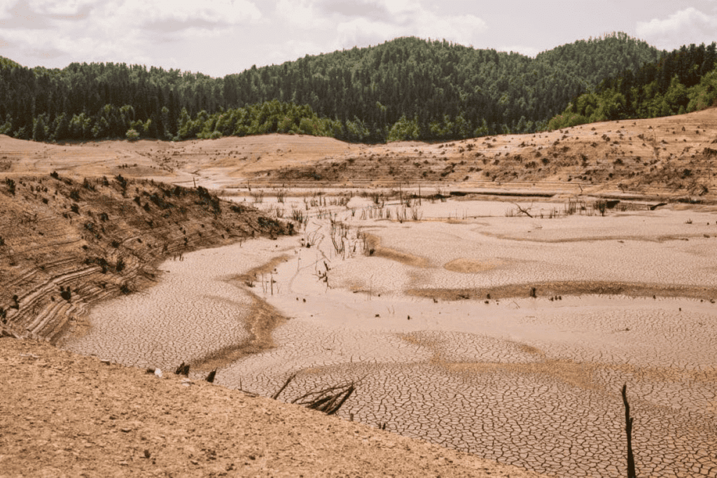
At the UNCCD COP16 in Riyadh, the UN Convention to Combat Desertification (UNCCD) and the European Commission's Joint Research Centre launched the World Drought Atlas, a comprehensive global publication on drought risks and solutions.
Key Takeaways
- Systemic Nature of Drought Risks: By 2050, 75% of the world's population (approximately 3 in 4 people) could be affected by drought conditions if current trends persist.
- In 2022 and 2023, around 1.84 billion people (nearly 1 in 4 globally) experienced drought, with about 85% occurring in low- and middle-income countries.
- Economic Consequences: Droughts severely impact agriculture, energy production, and trade, with their economic costs underestimated by 2.4 times, amounting to USD 307 billion annually.
- Drought Vulnerability in India: India is particularly susceptible to drought due to diverse climatic conditions and reliance on monsoon rains, with about 60% of agricultural land being rain-fed.
- The 2016 drought in Southern India was attributed to exceptionally low rainfall during both summer and winter monsoons.
- Rapid urbanization has led to water mismanagement in cities like Chennai, causing severe crises despite adequate rainfall.
Additional Details
- Human Impact: The UNCCD report attributes drought and resource degradation to human activities and occasional lack of rain.
- Key Recommendations: Countries should develop comprehensive national drought plans to improve preparedness and resilience, enhance international collaboration, and establish financial mechanisms like microinsurance for smallholder farmers.
- Land Use Management: Implement sustainable agriculture practices, such as land restoration, soil conservation, crop diversification, and agroforestry, to enhance resilience against drought.
- Water Management: Investment in infrastructure for water supply and management, including wastewater reuse and groundwater recharge systems, is necessary to improve water security during droughts.
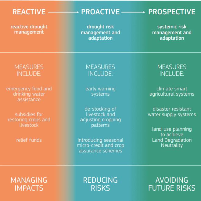
In conclusion, the World Drought Atlas serves as a critical tool for understanding and addressing the multifaceted challenges posed by drought, particularly in vulnerable regions like India. By implementing the recommendations outlined in the atlas, countries can enhance their preparedness and resilience against future drought events.
Ninetyeast Ridge
Why in News?
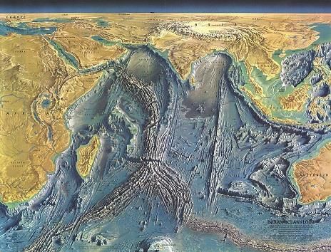
A recent study published in Nature Communications reveals that the Ninetyeast Ridge, known as the Earth's longest straight underwater mountain chain, was formed by a moving hotspot. This finding challenges the earlier belief that it originated from a stationary hotspot, providing new insights into Earth’s tectonic processes and age estimates of the Ninetyeast Ridge.
Key Takeaways
- Formation by a Moving Hotspot: The Ninetyeast Ridge, a 5,000 km-long underwater mountain chain in the Indian Ocean, was formed by the Kerguelen hotspot, which moved several hundred kilometers within the Earth's mantle.
- Age Estimates: High-precision dating of mineral samples indicates that the Ninetyeast Ridge formed between 83 and 43 million years ago.
- Impact on Tectonic Models: This study contributes to a more accurate reconstruction of Earth's tectonic history and emphasizes the importance of understanding mantle dynamics and hotspot movement for predicting natural disasters.
Additional Details
- Ninetyeast Ridge: This linear aseismic ridge is named for its near-parallel alignment with the 90 meridian east, stretching approximately 5,000 kilometers from the Bay of Bengal in the north to the Southeast Indian Ridge (SEIR) in the south.
- It features massive volcanoes in the northern segment, a tall and continuous southern part, and small seamounts in the middle section, effectively dividing the Indian Ocean into the West Indian Ocean and the Eastern Indian Ocean.
- Formation Process: The widely accepted hotspot theory attributes the ridge's formation to the Kerguelen hotspot as the Indo-Australian plate moved northward. Further research is ongoing to confirm this theory.
- Composition: The ridge is primarily made of Ocean Island Tholeiites (OIT), a type of sub-alkaline basalt rock, with younger rocks in the southern part (43.2 million years) compared to the northern part (81.8 million years).
Geological Significance of a Hotspot
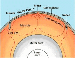
- Hotspot Definition: A hotspot is an area where hot plumes of molten rock (magma) rise deep within Earth's mantle, forming volcanoes when these plumes reach the surface.
- Unlike most volcanic activity driven by tectonic plate boundaries, hotspot volcanism occurs from stationary plumes beneath moving plates.
Hotspot Volcanism vs. Submarine Volcanism
- Hotspot volcanism occurs within lithospheric plates, while submarine volcanism happens at tectonic plate boundaries.
- Hotspot Track: As tectonic plates move over a hotspot, active volcanoes form above the plume, while older ones are carried away, creating a linear chain of islands or seamounts.
- The Hawaiian Islands exemplify a hotspot track, with the Island of Hawaii being the youngest and most active.
Impact of Hotspots on Tectonic Plates and Natural Disasters
- Volcanic Chains and Plate Movement: The arrangement of islands from youngest to oldest provides evidence for plate motion and allows scientists to estimate plate speed.
- Hotspots are linked to geothermal features like geysers, which offer insights into tectonic plate movements and interactions.
- Rifting and Continental Breakup: Hotspots can cause continental rifting by weakening the lithosphere beneath a continent, as seen in the East African Rift.
- Mantle Influence on Natural Disasters: Mantle plumes can lead to earthquakes, and understanding these dynamics is crucial for early warning systems. Additionally, underwater volcanic eruptions can trigger tsunamis.
Lake-Effect Snow
Why in News?
Recently, regions in upstate New York, Pennsylvania, Ohio, and Michigan, located along the Great Lakes of North America, experienced significant snowfall known as "lake-effect snow." A recent heavy snowstorm near Lake Erie in New York has resulted in homes being enveloped in layers of ice, resembling igloos.
Key Takeaways
- Lake-effect snow is a localized weather event leading to heavy snowfall.
- This phenomenon occurs primarily during the colder months when cold air interacts with warmer lake waters.
Additional Details
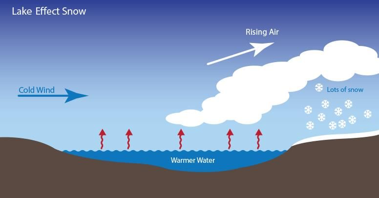
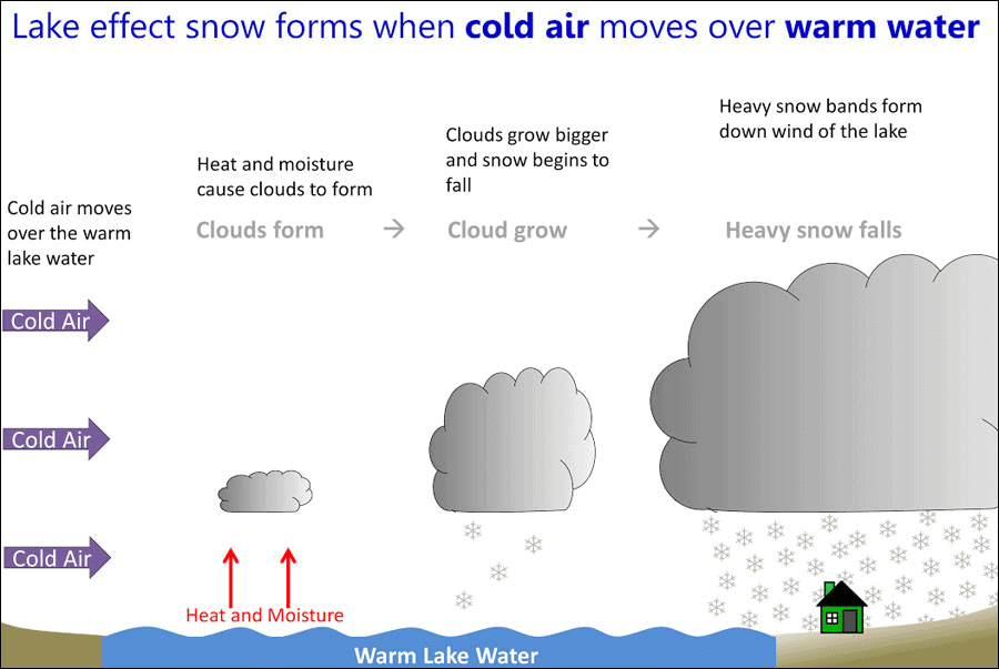
- Definition: Lake-effect snow is a weather phenomenon that results in intense snowfall near large bodies of water, particularly the Great Lakes, due to the temperature difference between the cold air and warmer lake waters.
- Mechanism of Formation:
- Cold Air Movement: Cold air, often originating from Canada, moves over the warmer, unfrozen waters of the Great Lakes, where the lakes provide heat and moisture to the air.
- Cloud Formation: The warm, moist air rises and cools quickly in the upper colder atmosphere, leading to cloud condensation.
- Snowfall: These clouds evolve into narrow bands that can deliver heavy snowfall, with rates reaching 2-3 inches or more per hour.
This weather phenomenon is crucial for understanding local climatic conditions and impacts regional weather patterns. The heavy snowfall can significantly affect transportation, infrastructure, and daily life in the affected areas.
Rapid Expansion of Himalayan Glacial Lakes
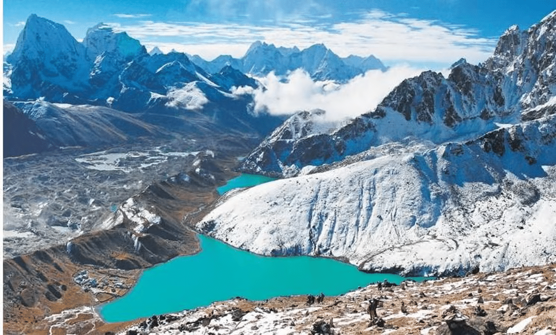
- Expansion of Himalayan glacial lakes: The area of glacial lakes in the Himalayan region has increased by 10.8% from 2011 to 2024, mainly due to climate change. This growth poses a threat to local communities and wildlife because it raises the likelihood of Glacial Lake Outburst Floods (GLOFs).
- India's glacial lakes: In India, the surface area of glacial lakes has expanded by a significant 34%, indicating a marked rise in their size.
- High-risk lakes: There are 67 lakes in India that have seen an increase of more than 40% in their surface area, categorizing them as high risk for possible GLOFs.
- Transboundary risks: The expanding glacial lakes also create risks that cross borders, particularly affecting Bhutan, Nepal, and China.
- Monitoring methods: The monitoring of these changes has been conducted using advanced satellite technology, specifically ‘Sentinel-1’ and ‘Sentinel-2’, which utilize Synthetic Aperture Radar and other imaging techniques.
What are glacial lakes?
- Glacial lakes are bodies of water that form from glaciers. They occur when a glacier erodes the land and then melts, filling the depressions left behind.
About GLOFs:
- GLOFs are sudden releases of water from a glacial lake, which can be found in various locations such as in front of, beside, underneath, or on top of a glacier. This release can cause large volumes of water to flow rapidly into nearby rivers.
- For example, in October 2023, a GLOF occurred in Sikkim due to the bursting of South Lhonak Lake.
About CWC:
- Headquarters: Located in New Delhi.
- Established: Founded in 1945 based on the advice of Dr. B. R. Ambedkar.
- Ministry: Operates under the Ministry of Jal Shakti.
- Leadership: Led by a Chairman, who is also an Ex-officio Secretary to the Government of India.
- Aim: The primary goal is to promote integrated and sustainable development and management of water resources in India.
- Scope: The CWC focuses only on surface water, while the Central Groundwater Board (CGWB) is responsible for groundwater management.
Challenging Big Bang Theory
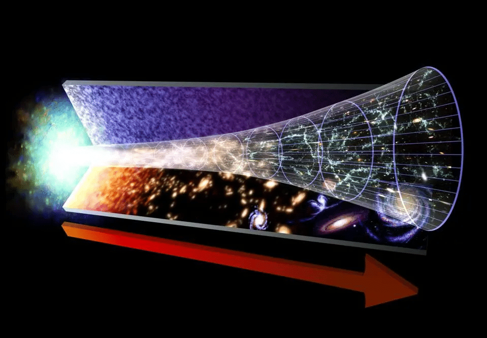
The Big Bang theory describes how the Universe began and developed. It suggests that the Universe expanded from a very tiny, hot, and dense state known as Singularity. Since then, it has grown larger, becoming cooler and less dense.
Key Features of the Big Bang Theory
- The Big Bang model explains how matter, space, and time originated around 13.7 billion years ago.
- The theory has several main characteristics and predictions that have been supported by numerous observations and experiments.
Evolution of the Big Bang Theory
- Einstein's General Theory of Relativity (1915): Laid the groundwork for understanding space and time, crucial for the Big Bang Theory.
- Karl Schwarzschild's Solution (1916): Provided a solution that describes a non-rotating black hole.
- Alexander Friedmann's Solution (1922): Discovered equations for a universe that is isotropic (looks the same in all directions) and homogeneous (uniform throughout).
- Georges Lemaitre (1927-1931): Proposed the idea of a concentrated mass point, suggesting the beginning of space and time.
Formation of the Present Universe
- The Big Bang theory states that the universe started from an infinitely hot and dense point, or singularity, about 13.7 billion years ago.
Understanding Singularity
- Singularity: A point where the usual laws of physics don't apply, characterized by infinite density and gravity. It occurs at the center of black holes and during the Big Bang.
- This model suggests the universe began from a very dense and massive point where space and time were non-existent, known as the Big Bang singularity.
- Planck Epoch: The earliest period in the universe, before which current physical theories cannot explain events due to extreme conditions.
- Instability: The universe was in a highly unstable state because of the extreme heat and density of matter.
The Big Bang Event
- Cosmic Inflation: In the initial moments (10^-32 seconds) about 13.8 billion years ago, the universe underwent rapid expansion.
- The Explosion: Following inflation, the universe expanded explosively.
- Formation of Matter and Light: Energy from the Big Bang turned into matter and light, leading to the creation of basic building blocks like atoms and molecules.
- Fundamental Forces: Along with matter and light, fundamental forces like strong and weak nuclear forces and electromagnetism came into existence.
- Evolution of Complex Structures: As the universe cooled and expanded, it formed stars, planets, and galaxies, a process that continues today.
Evidence Supporting the Big Bang Theory
- Evidence for the theory includes the ongoing expansion of the universe and findings from the Cosmic Microwave Background Radiation (CMBR).
The Expanding Universe
- Hubble's Observations: In 1924, astronomer Edwin Hubble showed that the universe is not static; galaxies are moving away from each other, and the farther they are, the faster they move away.
- Spatial Expansion Analogy: Hubble used the analogy of dots on an expanding balloon to illustrate that as the balloon inflates, dots (representing galaxies) move further apart.
- Hubble's Discoveries: His work not only proved the universe's expansion but also revealed the existence of galaxies beyond the Milky Way.
Cosmic Microwave Background Radiation (CMBR)
- Discovered by Penzias and Wilson, CMBR is the leftover heat from the Big Bang.
- Originally, the temperature at the time of the Big Bang was extremely high, but today it is measured at about 2.7 Kelvin, and this radiation is found throughout the universe.
- Temperature Variations: Studies like the Cosmic Background Explorer (COBE) and the Wilkinson Microwave Anisotropy Probe (WMAP) measured temperature differences in CMBR, supporting the Big Bang theory.
- The uniformity of CMBR in different directions, along with slight temperature variations, aligns with predictions from the Big Bang theory.
Evidence Against the Big Bang Theory
- Light Elements (Lithium and Helium): The Big Bang theory predicts a certain amount of lithium and a large amount of helium, but older stars have less lithium than expected.
- Antimatter-Matter Annihilation: The theory suggests equal amounts of matter and antimatter should have been created, but the observed matter density is much higher than predicted.
- Surface Brightness: As the universe expands, distant objects should appear dimmer, yet their surface brightness remains constant with distance.
- CMB Anomalies: While CMB is a remnant of the Big Bang, some anomalies observed do not match predictions, leading to questions about the inflation theory.
- Dark Matter: The Big Bang theory assumes dark matter exists, yet evidence from galaxy motions raises doubts about its presence.
Alternative Theories of the Universe
- Steady State Theory: An older theory suggesting that matter is continuously created to explain the universe's expansion. This idea is mostly rejected due to the discovery of CMBR, which supports the Big Bang.
- Causal Set Theory: This theory views space-time as a series of discrete pieces, or "atoms," rather than a smooth continuum, establishing limits on how close events can be in space and time.
- Multiverse Theory: Proposes that multiple universes exist, each with its own physical laws, suggesting our universe may be one of many formed from a large quantum multiverse.
India’s Ancient Water Harvesting System
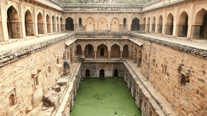
Recently, the Cumbum tank in Andhra Pradesh gained attention for its ancient water harvesting system.
About the Cumbum Tank
- Construction: The tank was created by Princess Varadharajamma of the Vijayanagara dynasty, also known as Ruchidevi, between 1522 and 1524 AD. It was built by blocking a gorge where the Gundlakamma and Jampaleru rivers flow.
- Geographical Features: The tank is supplied by the Nallamallavagu, a stream that comes from the Nallamala hills in the Eastern Ghats. It is part of the Gundlakamma river system.
- Technological Insights: British engineer Sir Arthur Cotton, known for his work in irrigation in South India, noted that earthen embankments built without reinforcement have stood the test of time. A puddled bank refers to a vertical clay wall between the natural ground level and any new materials placed above it.
- Restoration Efforts: The Andhra Pradesh government, with help from the Japanese International Cooperation Agency (JICA), has updated and modernized the tank.
Water Management in Indian History
- Indus Valley Civilization: Dholavira had reservoirs for rainwater, while Lothal and Inamgaon built small bunds to store water for irrigation and drinking.
- Mauryan Empire: The Arthashastra by Kautilya mentions extensive irrigation systems, including dams and bunds, managed under strict regulations. Taxes were collected based on how water was extracted.
- Early Medieval India: The Satavahanas introduced brick and ring wells. The Chola period saw the development of chain tanks for better water distribution. The Rajputs built large reservoirs, like Bhopal Lake under King Bhoja, while the Pal and Sen dynasties constructed many tanks and lakes in eastern India.
- Medieval Period: Feroze Shah Tughlaq created the Western Yamuna Canal, and Emperor Shahjahan developed the Bari Doab or Hasli Canal. The Vijayanagar Kingdom built tanks such as Anantraj Sagar and Korangal Dam. Sultan Zain Uddin established a vast canal network in Kashmir.
What is a Water Harvesting System?
- About: A water harvesting system is a technique or structure used to capture, store, and utilize rainwater, surface runoff, or other water sources for various uses, including agriculture and domestic needs. This practice aims to conserve water and address scarcity.
- Types:
- Rainwater Harvesting (RWH): Collecting and storing rainwater through methods like rooftop collection and underground storage to save water.
- Groundwater Recharge Systems: Techniques such as recharge wells that allow rainwater to seep into the ground to maintain groundwater levels.
- Surface Water Harvesting: Collecting rainwater from land or open fields using ponds and reservoirs for irrigation and other uses.
- Urban Water Harvesting: Capturing rainwater in urban areas from rooftops and surfaces to relieve pressure on municipal water systems and manage stormwater.
- Significance:
- Reliable Water Source: Provides a consistent water supply with minimal evaporation or pollution, suitable for daily use. It also improves groundwater quality and helps prevent seawater intrusion in coastal regions.
- Flood Prevention: Lowers the risk of floods and waterlogging, protecting property and infrastructure while minimizing erosion and flooding.
- Groundwater Recharge: Replenishes groundwater to enhance availability during dry spells, reducing surface runoff and preserving soil.
- Sustainability: Encourages water conservation and helps combat groundwater depletion amid urban growth.
India's Initiatives Related to Water Conservation
- National Water Policy, 2012
- National Aquifer Mapping and Management Program (NAQUIM)
- Mission Amrit Sarovar
- Jal Jeevan Mission (JJM)
- Jal Shakti Abhiyan (JSA)
- Atal Bhujal Yojana (ABY)
Including Non Mineralized Areas in Mining Leases
Why in News?
- The Centre has allowed state governments to add non-mineralized areas to current mining leases for dumping mine waste and overburden, simplifying operations and tackling industry issues.
- The Ministry of Mines stated that according to the Mines and Minerals (Development and Regulation) Act, 1957, non-mineralized areas can be included in a mining lease for activities like waste disposal.
- This interpretation is backed by the Mines Act, 1952, and Rule 57 of the Mineral Concession Rules, 2016, which permit inclusion of ancillary zones in the lease area.
What are the Supreme Court Rulings for Regulating Mining and Minerals?
- Centre’s Primary Authority: A 1989 ruling in the India Cement Ltd. v. State of Tamil Nadu case determined that mining regulation is mainly under the Centre's control through the Mines and Minerals (Development and Regulation) Act, 1957, and Entry 54 of the Union List.
- State Authority on Taxes: The ruling in the State of Orissa v. M.A. Tulloch & Co. case established that states can collect royalties but cannot impose extra taxes, as royalties are considered taxes.
- A 2004 decision in State of West Bengal v. Kesoram Industries Ltd. questioned this classification, leading to a review by a nine-judge bench.
- Overturning 1989 Verdict: In July 2024, the Court decided in favor of states, reversing the 1989 judgement and confirming their right to tax mineral rights under Entry 50 of List II (State List), while limiting Parliament's role to ensuring that mineral development is not obstructed.
- Some judges warned that unregulated state taxation could disrupt federal consistency in mineral pricing and development, and advised Parliament to step in for uniformity.
Goa Foundation v. Union of India Case, 2014: Against Dumping Outside Valid Lease Areas
- Prohibition of External Dumping: The Supreme Court ruled that dumping mine waste or overburden outside valid mining lease boundaries is not allowed to avoid environmental and legal issues.
- Protection of Non-Lease Areas: The ruling highlighted that non-lease areas must not be used for mining-related activities, ensuring their protection and proper regulation.
- Alignment with Mining Laws: The Court's decision reinforced compliance with the Mines and Minerals (Development and Regulation) Act, 1957 and related laws that restrict unauthorized land use.
- Impact on Mining Practices: Mining operations now need to manage waste within leased areas, leading to changes in planning and land use.
What are the Implications of the Recent Inclusion of Non-Mineralised Areas?
- Streamlined Operations: Adding non-mineralized areas to mining leases allows for safe and effective management of overburden and waste, addressing operational challenges in the industry.
- Overburden Management: Overburden refers to rocks, soil, and materials removed to access minerals, which need to be managed properly for safe mining.
- Non-mineralized areas, which do not have significant mineral deposits, can be designated by state governments for waste disposal, and included in mining leases without auction if they are connected.
- Aligned with 2014 Ruling: This change is in line with the Supreme Court's 2014 ruling against dumping outside valid lease areas.
- Efficient Land Utilization: Allowing waste disposal within lease areas optimizes the use of non-mineralized zones without requiring separate auctions for these purposes.
- Industry Growth: This eases operational difficulties, promoting sustainable mineral extraction and encouraging growth in the mining sector.
- States can designate both contiguous and non-contiguous non-mineralized areas for waste management if it supports mineral development, offering operational flexibility.
- Safeguards Against Misuse: States must verify non-mineralized areas, consult the Indian Bureau of Mines (IBM) for extent assessment, and inform IBM about additional leases to prevent illegal mineral extraction.
What is the Mines and Minerals (Development and Regulation) Act, 1957?
- Pivotal Legislation: This Act oversees India's mining sector, aiming to develop the industry, conserve minerals, and ensure transparency and efficiency in mineral exploitation.
- Initial Objectives: The Act was originally focused on promoting mining, conserving resources, and regulating concessions.
- 2015 Amendment: Introduced major reforms including the Auction Method for transparency, the creation of the District Mineral Foundation (DMF) for mining-affected areas, the National Mineral Exploration Trust (NMET) to enhance exploration, and strict penalties for illegal mining.
- 2021 Amendment: Companies operating captive mines can extract minerals for their own use, with up to 50% of their annual production allowed to be sold in the open market after meeting end-use requirements.
- Merchant mines produce minerals for sale in the open market, with the extracted minerals sold to various buyers, including industries without their own mines.
- Auction-only concessions require that all private-sector mineral concessions be awarded through auctions.
- 2023 Amendment: The Mines and Minerals (Development and Regulation) Amendment Act, 2023, aims to boost the exploration and extraction of critical minerals essential for India's economic growth and national security.
- Key changes involve removing six minerals from the list of 12 atomic minerals reserved for state agency exploration and allowing the government to exclusively auction concessions for critical minerals.
- Exploration licenses have been introduced to attract foreign direct investment and engage junior mining companies in exploring deep-seated and critical minerals.
- The amendments focus on reducing import dependence and encouraging private sector participation to expedite the mining of essential minerals like lithium, graphite, cobalt, titanium, and rare earth elements, supporting India's energy transition and commitment to achieving net-zero emissions by 2070.
|
39 videos|4375 docs|923 tests
|
FAQs on Geography: December 2024 UPSC Current Affairs - Current Affairs & Hindu Analysis: Daily, Weekly & Monthly
| 1. What is the significance of International Mountain Day and how is it celebrated? |  |
| 2. What is the UNCCD's Drought Atlas and what purpose does it serve? |  |
| 3. What is the Ninetyeast Ridge and why is it important in geological studies? |  |
| 4. How does lake-effect snow occur and what regions are most affected by it? |  |
| 5. What are the implications of the rapid expansion of Himalayan glacial lakes for the environment? |  |
|
39 videos|4375 docs|923 tests
|


