CBSE Class 5 > Class 5 Notes > Social Studies > Globes and Maps
Globes and Maps

The document Globes and Maps is a part of the Class 5 Course Social Studies for Class 5.
All you need of Class 5 at this link: Class 5
FAQs on Globes and Maps
| 1. What is the difference between a globe and a map? |  |
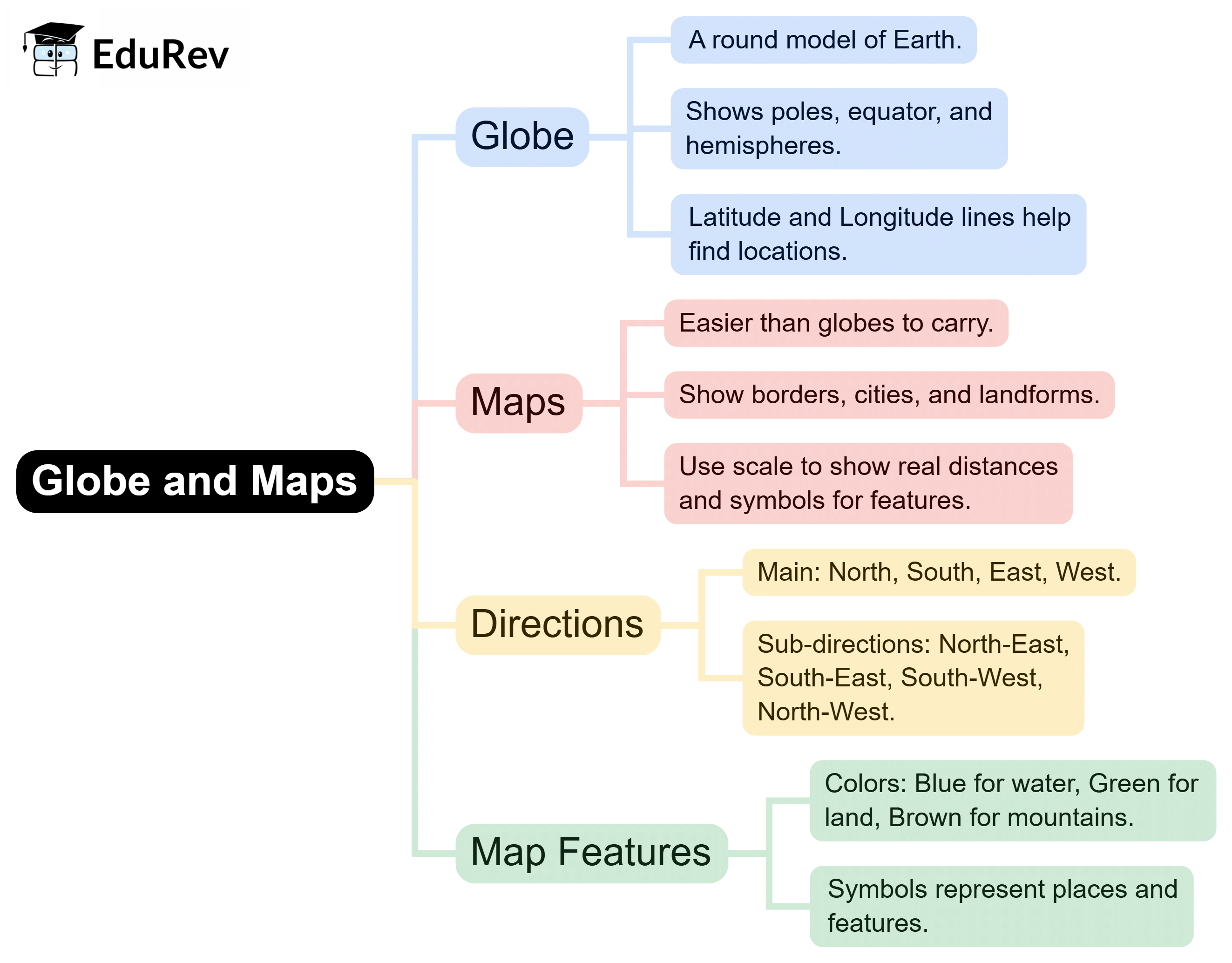
Ans. A globe is a three-dimensional representation of the Earth, showing its shape, size, and geographical features accurately. In contrast, a map is a two-dimensional representation, which can distort shapes and distances but provides detailed information about specific areas, such as roads, borders, and landmarks.
| 2. Why are maps important for navigation? | |
Ans. Maps are essential for navigation as they provide a visual representation of an area, helping people understand where they are, where they want to go, and how to get there. They include important information like roads, distances, and terrain, making it easier to plan routes and avoid obstacles.
| 3. What are the different types of maps? | |
Ans. There are several types of maps, including physical maps, which show natural features like mountains and rivers; political maps, which display boundaries and cities; thematic maps, which focus on specific topics like climate or population; and topographic maps, which illustrate elevation and landforms.
| 4. How do you read a map? | |
Ans. To read a map, start by identifying the map's key or legend, which explains the symbols used. Next, look for the compass rose to understand the orientation (north, south, east, west). Then, locate your position and the destination, using the scale to measure distances accurately.
| 5. What is the significance of the equator and the prime meridian on a globe? | |
Ans. The equator is an imaginary line that divides the Earth into the Northern and Southern Hemispheres, serving as a reference point for latitude. The prime meridian is another imaginary line that divides the Earth into the Eastern and Western Hemispheres, serving as a reference for longitude. Together, they help in locating places on the globe.
About this Document

1.2K Views

4.89/5 Rating

Apr 29, 2026 Last updated
Document Description: Globes and Maps for Class 5 2026 is part of Social Studies for Class 5 preparation. The notes and questions for Globes and Maps have been prepared according to the Class 5 exam syllabus. Information about Globes and Maps covers topics like and Globes and Maps Example, for Class 5 2026 Exam. Find important definitions, questions, notes, meanings, examples, exercises and tests below for Globes and Maps.
Introduction of Globes and Maps in English is available as part of our Social Studies for Class 5 for Class 5 & Globes and Maps in Hindi for Social Studies for Class 5 course. Download more important topics related with notes, lectures and mock test series for Class 5 Exam by signing up for free. Class 5: Globes and Maps
Description
Globes & Maps of SST covers all the important topics, helping you prepare for the Class 5 exam on EduRev. Start for free!
Information about Globes and Maps
In this doc you can find the meaning of Globes and Maps defined & explained in the simplest way possible. Besides explaining types of Globes and Maps theory, EduRev gives you an ample number of questions to practice Globes and Maps tests, examples and also practice Class 5 tests


Related Searches
Globes and Maps, pdf , Extra Questions, past year papers, ppt, Semester Notes, Objective type Questions, Previous Year Questions with Solutions, MCQs, Globes and Maps, Globes and Maps, Important questions, video lectures, Sample Paper, practice quizzes, Free, Exam, Viva Questions, Summary, mock tests for examination, study material, shortcuts and tricks;