CBSE Class 6 > Class 6 Notes > Social Studies > NCERT Summary: Locating Places on the Earth
NCERT Summary: Locating Places on the Earth

Maps
A map is a visual representation of an area, showing features like mountains, rivers, cities, and roads. It can vary in complexity based on the level of detail included.
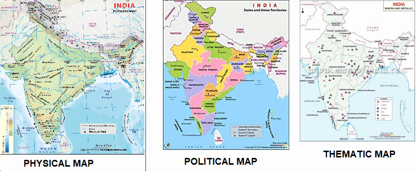
- Physical Maps: Show natural features (mountains, rivers, lakes).
- Political Maps: Show boundaries of countries, states, and cities.
- Thematic Maps: Focus on specific information like population or climate.
Components of a Map
- Distance: Represented using a scale that shows the relationship between map distances and actual distances.
- Direction: Maps use main directions (North, South, East, West) and in-between directions (Northeast, Southwest, etc.) to guide us.
- Symbols: Represent features (e.g., trees for forests, dotted lines for roads). Explained in the map's legend or key.
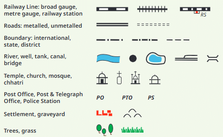 Selection of Symbols Commonly used in Maps
MULTIPLE CHOICE QUESTIONTry yourself: What do physical maps show?
Mapping the Earth
- Earth is a sphere, so representing it on a flat map is challenging.
- Globe: More accurate representation but maps are more convenient.
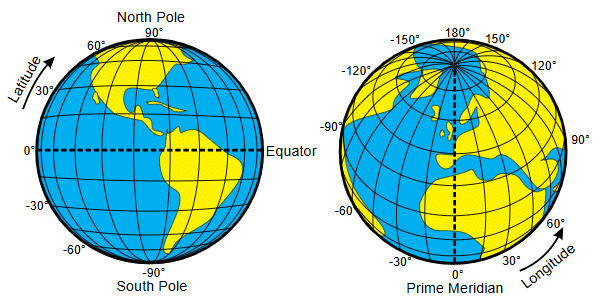
Latitude and Longitude (Coordinates)
Latitude:
- Latitude lines are horizontal, running parallel to the Equator.
- They measure the distance north or south from the Equator.
- Equator: 0° latitude; North Pole: 90°N; South Pole: 90°S.
- Important latitudes: Tropic of Cancer (23.5°N), Tropic of Capricorn (23.5°S).
- Climate Zones: Latitude affects climate, dividing Earth into torrid, temperate, and frigid zones.
 Latitude and Longitude
Longitude:
- Longitude lines are vertical, running from the North Pole to the South Pole.
- They measure the distance east or west from the Prime Meridian (0° longitude) in Greenwich, England.
- Important longitude: International Date Line (180° longitude), where the date changes.
Coordinates:
- A location on Earth is given by its latitude (north/south) and longitude (east/west).
- Example: New York is 40.7128°N, 74.0060°W.
Importance:
- Navigation: Latitude and longitude are crucial for locating places and navigation.
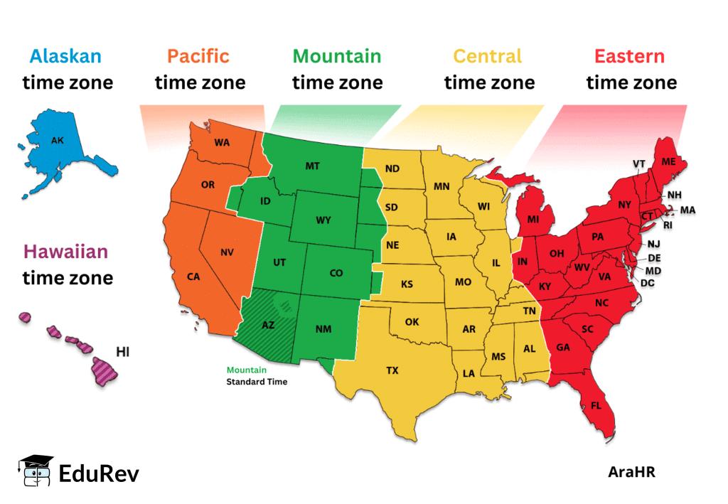
- Time Zones: Longitude helps determine local time, with each time zone spanning 15° of longitude.
Try yourself: What is the Equator's latitude?MULTIPLE CHOICE QUESTION
Understanding Time Zones
- Earth's rotation divides it into 24 time zones, each 15° of longitude wide.
- Local Time: Determined by longitude; places on the same longitude share the same time.
- International Date Line: Located at 180° longitude, crossing it changes the date (adds or subtracts a day).
In summary, latitude and longitude form the basic system that enables us to locate any point on Earth. By measuring distances from the Equator (latitude) and the Prime Meridian (longitude), we can identify specific locations, navigate, and understand global positioning in terms of both geography and time.
The document NCERT Summary: Locating Places on the Earth is a part of the Class 6 Course Social Studies for Class 6.
All you need of Class 6 at this link: Class 6
FAQs on NCERT Summary: Locating Places on the Earth
| 1. What are the different types of maps commonly used? |  |
Ans. There are several types of maps, including physical maps that show natural features like mountains and rivers, political maps that display boundaries and cities, thematic maps that focus on specific topics like climate or population, and topographic maps that illustrate terrain using contour lines.
| 2. How does latitude and longitude work in locating places on Earth? | |
Ans. Latitude and longitude are a system of coordinates used to pinpoint locations on the Earth's surface. Latitude lines run horizontally and measure north or south of the equator, while longitude lines run vertically and measure east or west of the Prime Meridian. Each location is identified by its specific latitude and longitude coordinates.
| 3. Why are time zones important in understanding geography? | |
Ans. Time zones are crucial for coordinating activities across different regions. The Earth is divided into 24 time zones, each generally one hour apart, reflecting the rotation of the Earth. Understanding time zones helps in scheduling events, travel, and communication between places located in different parts of the world.
| 4. How do maps help us understand our environment better? | |
Ans. Maps provide a visual representation of geographic data, making it easier to understand the relationships between different locations, natural features, and human-made structures. They can help us analyze patterns, navigate through areas, and plan for various activities such as travel, land use, and resource management.
| 5. What is the significance of the Prime Meridian and the equator in geography? | |
Ans. The Prime Meridian is the zero-degree longitude line that divides the Eastern and Western Hemispheres, while the equator is the zero-degree latitude line that separates the Northern and Southern Hemispheres. These lines are essential reference points for navigation, timekeeping, and understanding global geography.
About this Document

5K Views

4.78/5 Rating

Apr 29, 2026 Last updated
Related Exams
Document Description: NCERT Summary: Locating Places on the Earth for Class 6 2026 is part of Social Studies for Class 6 preparation. The notes and questions for NCERT Summary: Locating Places on the Earth have been prepared according to the Class 6 exam syllabus. Information about NCERT Summary: Locating Places on the Earth covers topics like and NCERT Summary: Locating Places on the Earth Example, for Class 6 2026 Exam. Find important definitions, questions, notes, meanings, examples, exercises and tests below for NCERT Summary: Locating Places on the Earth.
Introduction of NCERT Summary: Locating Places on the Earth in English is available as part of our Social Studies for Class 6 for Class 6 & NCERT Summary: Locating Places on the Earth in Hindi for Social Studies for Class 6 course. Download more important topics related with notes, lectures and mock test series for Class 6 Exam by signing up for free. Class 6: NCERT Summary: Locating Places on the Earth
Description
NCERT Summary: Locating Places on the Earth of SST - covers all the important topics from the book, explained in easy language for better understanding. Free PDF available for download.
Information about NCERT Summary: Locating Places on the Earth
In this doc you can find the meaning of NCERT Summary: Locating Places on the Earth defined & explained in the simplest way possible. Besides explaining types of NCERT Summary: Locating Places on the Earth theory, EduRev gives you an ample number of questions to practice NCERT Summary: Locating Places on the Earth tests, examples and also practice Class 6 tests


Related Searches
practice quizzes, NCERT Summary: Locating Places on the Earth, Exam, pdf , Summary, NCERT Summary: Locating Places on the Earth, Viva Questions, study material, Sample Paper, mock tests for examination, video lectures, Important questions, shortcuts and tricks, Free, ppt, NCERT Summary: Locating Places on the Earth, MCQs, past year papers, Objective type Questions, Extra Questions, Previous Year Questions with Solutions, Semester Notes;