Assignment: Locating Places on the Earth

MCQs
What is the primary function of a map?
(A) To show the history of a place
(B) To represent the Earth's surface
(C) To display the weather conditions
(D) To show political boundariesSolution: (B) To represent the Earth's surface.
A map is a representation of an area on the Earth's surface, showing various features like landforms, cities, roads, etc.What is the equator's latitude?
(A) 0°
(B) 90°N
(C) 90°S
(D) 180°Solution: (A) 0°.
The equator is located at 0° latitude, dividing the Earth into the Northern and Southern Hemispheres.What does the scale of a map represent?
(A) The size of the map
(B) The actual distance represented on the map
(C) The number of countries shown on the map
(D) The number of cities shown on the mapSolution: (B) The actual distance represented on the map.
The scale helps convert distances on the map into actual distances on the Earth's surface.Which of the following is used to measure the distance from the Prime Meridian?
(A) Latitude
(B) Longitude
(C) Altitude
(D) DistanceSolution: (B) Longitude.
Longitude is measured in degrees east or west from the Prime Meridian, helping to determine a place's position east or west on Earth.What is the International Date Line?
(A) The line that marks the equator
(B) The line where the time changes by one day
(C) The line dividing two hemispheres
(D) The line marking the Prime MeridianSolution: (B) The line where the time changes by one day.
The International Date Line is located at approximately 180° longitude, where travelers must adjust the date when crossing it.
Short Q/A
What are the components of a map?
Solution: The main components of a map include distance, direction, and symbols. These components help in accurately representing and interpreting the information shown on the map.What is the difference between local time and standard time?
Solution: Local time is the time observed at a specific location based on its longitude, while standard time is the official time set for a country or region, usually based on a specific meridian.Why is a globe considered a better representation of the Earth than a flat map?
Solution: A globe, being spherical, accurately represents the Earth's geography, unlike a flat map that distorts shapes, sizes, and distances due to the difficulty in projecting a 3D surface onto a 2D plane.What do latitude and longitude together help us to do?
Solution: Latitude and longitude provide coordinates that allow us to locate any place on the Earth's surface with precision.How are time zones related to longitude?
Solution: Time zones are based on longitudes, with each time zone generally covering 15° of longitude. The local time increases by one hour for every 15° eastward from the Prime Meridian.
Activity-Based Questions
1. Draw a rough map of your locality or village, showing your home, school, and a few other landmarks. Use symbols to mark important features and show the cardinal directions.
Solution:
Draw the streets and landmarks of your locality on paper.
Use symbols like a triangle for a temple, a square for a school, and a circle for a railway station.
Mark the four cardinal directions (North, South, East, West) on the map to help identify the location of each feature.
Research-Based Question
1. Research: Find out the latitudes and longitudes of two major cities in India. Compare their differences in terms of local time.
Solution:
For example, Mumbai is located at 19°N latitude and 72°E longitude, while Delhi is at 29°N latitude and 77°E longitude.
The difference in their longitudes is 5° (77° - 72°). This means that the local time in Delhi is ahead of Mumbai by approximately 20 minutes (since each degree of longitude corresponds to a time difference of about 4 minutes).
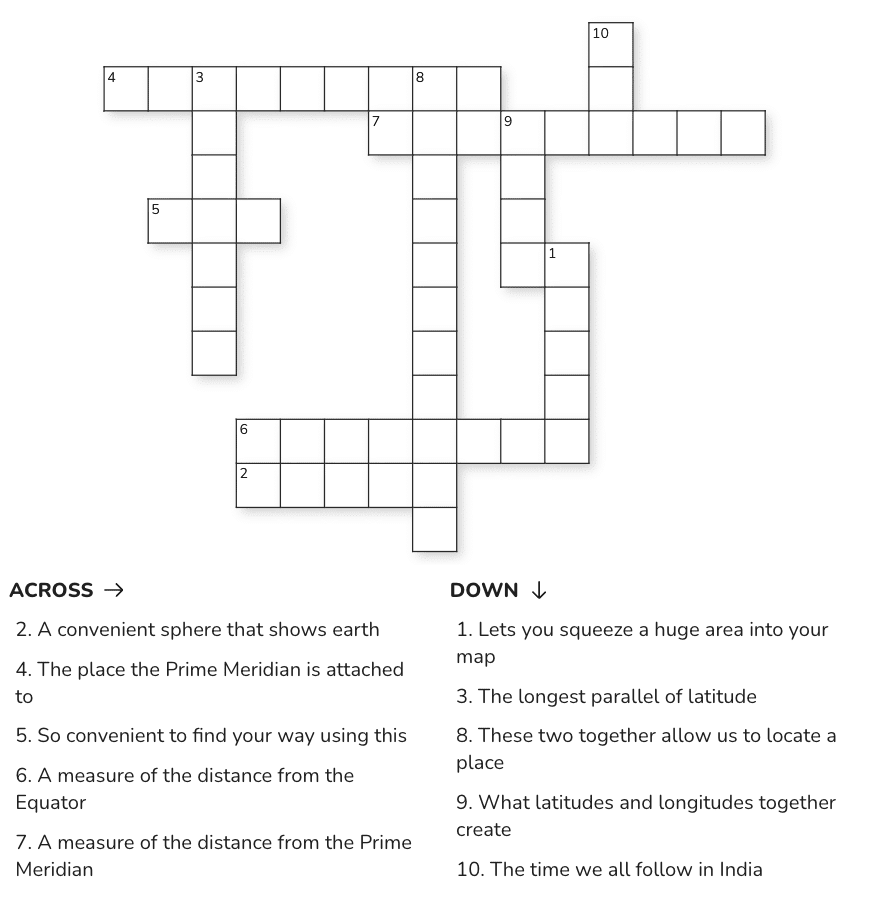
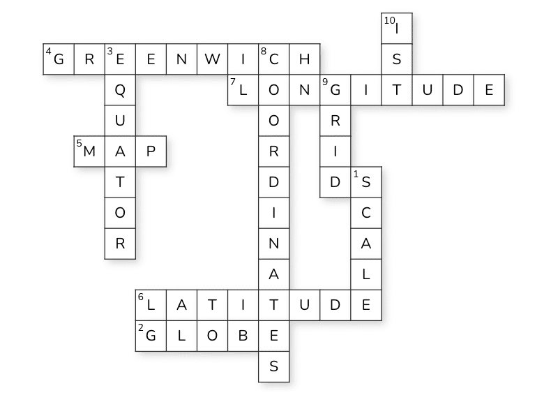
Crossword
Solution:
FAQs on Assignment: Locating Places on the Earth
| 1. What is the importance of locating places on Earth in geography? |  |
| 2. What are the different methods used to locate places on Earth? | |
| 3. How do latitude and longitude work in locating places? | |
| 4. What role do maps play in locating places on Earth? | |
| 5. Why is it essential for students to learn about locating places on Earth? | |


