Geographical Diversity of India Class 7 Notes Social Science Chapter 1 Free PDF

India’s unique geography sets it apart from many other countries, giving it a distinct national character, as noted by Sri Aurobindo.
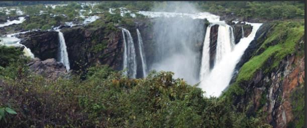 Jog Falls in Karnataka
- From the towering plateaus and majestic waterfalls like Jog Falls in Karnataka, to its vast and varied landscapes.
- India’s geographical diversity shapes not only its natural beauty but also the way people live across the country.
- In 1984, when Rakesh Sharma, the first Indian astronaut, was asked how India looked from space, he famously replied, “Sāre jahān se achchha” — better than the whole world — capturing the pride and uniqueness of India’s geography.
India's Geographical Diversity
India is the seventh-largest country in the world and an important part of the Indian Subcontinent, which also includes its neighbors like Pakistan, Bangladesh, Nepal, Bhutan, Sri Lanka, and Myanmar. Together, these countries form a region that is diverse in both culture and geography.
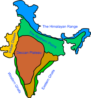 Physical Features of India
The Mountain Zone (The Himalayas)
The Plains of the Ganga and Indus
The Desert Region (The Thar Desert)
The Southern Peninsula
The Islands
- These regions create varied climates and lifestyles, with some areas having fertile plains for farming and others being arid deserts or cold mountains. The geographical features like mountains, rivers, deserts, and coasts help shape daily life, farming practices, and even festivals across India.
- India’s natural boundaries—The Himalayas to the north, The Thar Desert and Arabian Sea to the west, The Indian Ocean to the south, and The Bay of Bengal to the east—help define the country’s physical limits and contribute to the diverse ecosystems and cultures within it. This variety deeply affects how people live, farm, travel, and celebrate
The Himalayas
The Himalayas, India's mighty northern mountain range, act as a natural barrier, not only protecting the country but also influencing the climate and culture. These mountains stretch about 2,500 km across six countries: India, Nepal, Bhutan, China, Pakistan, and Afghanistan.
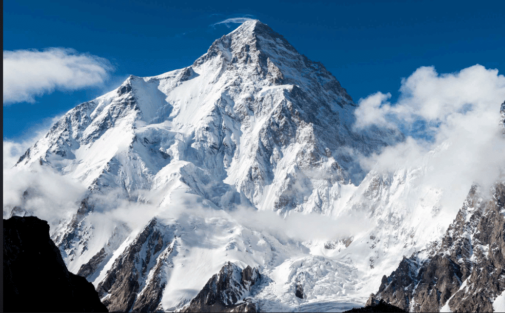 Himalayas
- The Himalayas are home to some of the world’s tallest peaks, including Mount Everest and Kanchenjunga, making it a region of extreme natural beauty and hardship.
In summer, the snow melts from the Himalayas, feeding rivers like the Ganga, Indus, and Brahmaputra, which supply water to millions for drinking, farming, and industries. This makes the Himalayas often referred to as the ‘Water Tower of Asia’.
The Himalayan range is divided into three main parts:
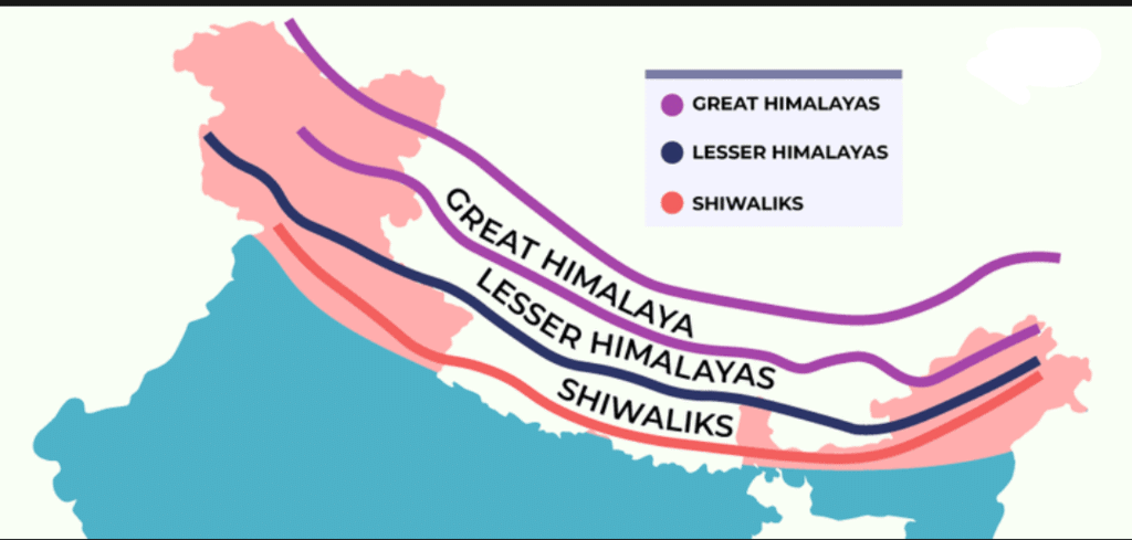 Himalayan Range
- Himadri (Greater Himalayas): This is the highest part, home to the Eight Thousanders, mountains towering over 8,000 meters. Very few people live here due to the extreme conditions.
- Himachal (Lower Himalayas): Known for hill stations like Shimla, Darjeeling, and Mussoorie, this range has a more moderate climate, rich biodiversity, and human habitation.
- Shivalik Hills (Outer Himalayas): The outermost range, lower in height and filled with dense forests, it forms the transition to the Gangetic Plains.
Don’t Miss Out
- The Great Himalayan National Park in Himachal Pradesh is home to many kinds of plants and animals.
- It is a World Heritage Site recognized by UNESCO.
- Both the government and the local village communities work together to protect the park’s plants and animals.
Great Himalayan National Park
How the Himalayas Were Formed: An Interesting Story
- India’s collision with Eurasia around 50 million years ago formed the Himalayas.
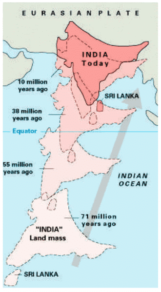 India's Journey to Eurasia
 - India, once part of a landmass called Gondwana, slowly moved north and collided with the Eurasian plate.
- This caused the land to crumple, much like how a carpet wrinkles when pushed, resulting in the towering peaks of the Himalayas.
- Even today, India is still pushing into Asia, making the mountains grow taller by about 5 mm every year.
- The word ‘Himalaya’ comes from Sanskrit, meaning "abode of snow."
The Cold Desert of India
Ladakh is India’s cold desert, where winter temperatures drop below -30°C.
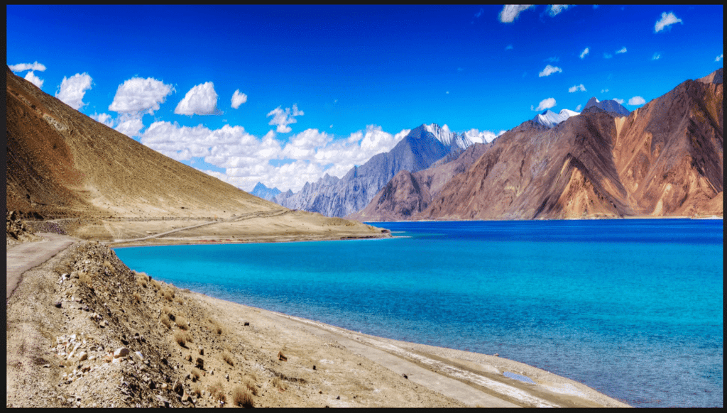 Ladakh- Cold Desert of India
- It gets very little rainfall, with rocky terrain, deep valleys, and lakes like Pangong Tso, a salty lake.
- The landscape, called moonland, looks like the moon due to its rugged, eroded rocks formed when India collided with Eurasia.
- Despite harsh conditions, Ladakh has unique wildlife like snow leopards, ibex, and Tibetan antelopes.
- Yaks are vital for the people, used for milk, meat, wool, dung, and transport.
- The Ladakhi people live simply and celebrate colorful festivals like Losar and Hemis Festival.
- The region has ancient monasteries and a unique culture.
The Gangetic Plains
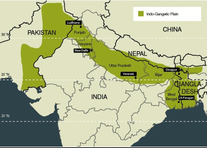
As we move southward from the Himalayas, we come to the Gangetic Plains, a large, flat area that is highly fertile and ideal for agriculture. These plains are nourished by rivers like the Ganga, Indus, and Brahmaputra.
 Indo-Gangetic Plain
- The Gangetic Plains, also called the Northern Plains, lie south of the Himalayas and are very fertile.
- They are watered by rivers like the Ganga, Indus, and Brahmaputra, which carry minerals from the Himalayas, making the soil ideal for agriculture.
- A large part of India’s population lives here, growing crops like rice and wheat.
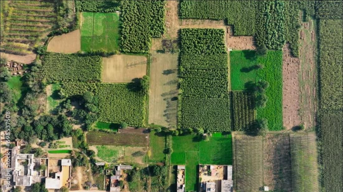 Multi Cropping in Gangetic Plains
- The flat land supports a vast transportation network of roads, railways, and rivers used for travel and trade for thousands of years.
- Rivers are named after goddesses like Ganga, Yamuna, and Kaveri, but Brahmaputra means “son of Brahma” and grows bigger in summer due to melting Himalayan snow.
- The plains are home to wildlife like the grey langur, tiger (protected by Project Tiger), and Indian gharial, a reptile on the verge of extinction.
- The peacock, India’s national bird, is also found here.
The Great Indian Desert or Thar Desert
The Thar Desert is a vast arid region in western India, covering Rajasthan, Gujarat, Punjab, and Haryana.
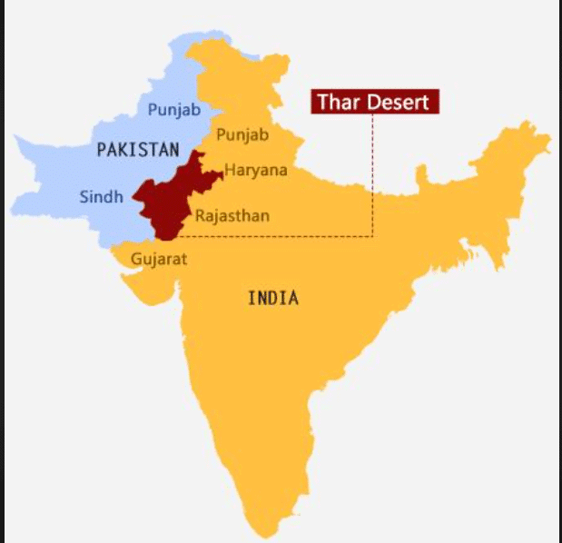 Thar Desert Location
- It has golden sand dunes, rugged terrain, and a wide-open sky, with dunes rising up to 150 meters formed by wind.
- Daytime temperatures are very high, and nights are cold, with little water available.
- People have adapted with special food, clothing, and lifestyles, like using camels for transport, seen at events like the Pushkar Mela.
- Jaisalmer, the Golden City, has a UNESCO World Heritage site, the Jaisalmer Fort.
- Water is scarce, so women travel long distances to fetch it, and utensils are cleaned with sand to save water.
- Rainwater harvesting systems like taanka or kunds store water for drinking.
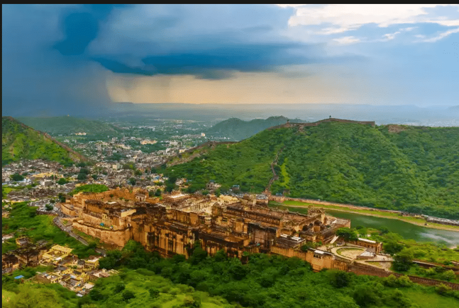
The Aravalli Hills
The Aravalli Hills are among the oldest mountains in the world, about 2.5 billion years old, spanning Delhi, Rajasthan, Haryana, and Gujarat.
 Aravalli Hills
- Their highest peak, Mount Abu, is over 1700 meters, but most hills are 300–900 meters high.
- They act as a natural barrier, stopping the Thar Desert from spreading eastward.
- The Aravallis are rich in minerals like marble, granite, zinc, and copper. Ancient mines at Zawar show India mastered zinc extraction over 800 years ago.
- Historic forts like Chittorgarh, Kumbhalgarh, and Ranthambore are located here, built in the hills for protection.
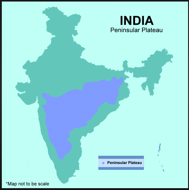
The Peninsular Plateau
A plateau is a flat, elevated landform with steep slopes. The Peninsular Plateau is a triangular area in central and southern India.
 Peninsular Plateau
- It is a peninsula, surrounded by water on three sides: the Arabian Sea, Bay of Bengal, and Indian Ocean.
- It is bordered by the Western Ghats (taller, with waterfalls) and Eastern Ghats (lower, broken hills).
- The Deccan Plateau lies between these ranges, a vast flat highland.
- Rivers like Godavari, Krishna, Kaveri, Narmada, and Tapti flow across it, supporting farming, industries, and hydroelectric power.
- The plateau tilts eastward, so most rivers flow toward the Bay of Bengal, except Narmada and Tapti, which flow to the Arabian Sea.
- It is rich in minerals, forests, and fertile land, vital for India’s economy.
- Dense forests are home to tribal communities like Santhal, Gond, Baiga, Bhil, and Korku, who have unique traditions tied to nature.
- Waterfalls on the plateau, like those at Periyakanal, attract tourists and support hydroelectric power.
- The Western Ghats are a UNESCO World Heritage Site with rich biodiversity, including the lion-tailed macaque and insectivorous plants.
Let's Revise: How do the rivers of the Peninsular Plateau flow, and why?
 View Answer
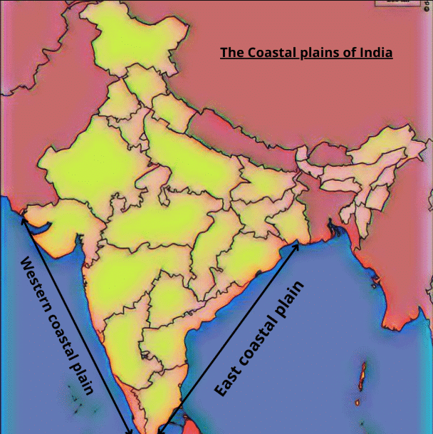
India’s Amazing Coastlines
India’s coastline is over 7500 km long, with beaches, rocky cliffs, forests, and coral reefs.
 Coasts of India
- Deltas are triangular landforms formed when rivers deposit sediments at their mouths, making the land fertile.
- Rivers from the Western Ghats form estuaries, with the Narmada and Tapti being the largest.
- It has ports and cities like Mumbai, India’s financial center, active for thousands of years.
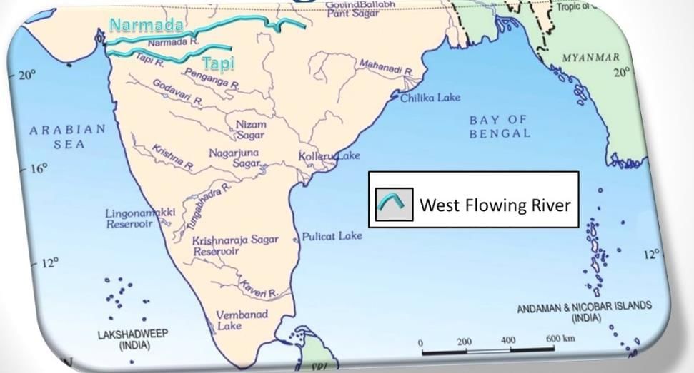 West flowing rivers
The East Coast (Ganga delta to Kanyakumari):
- It has wide plains and deltas from rivers like Mahanadi, Godavari, Krishna, and Kaveri, ideal for farming.
- Chilika Lake and Pulicat Lake (a lagoon) are important water bodies.
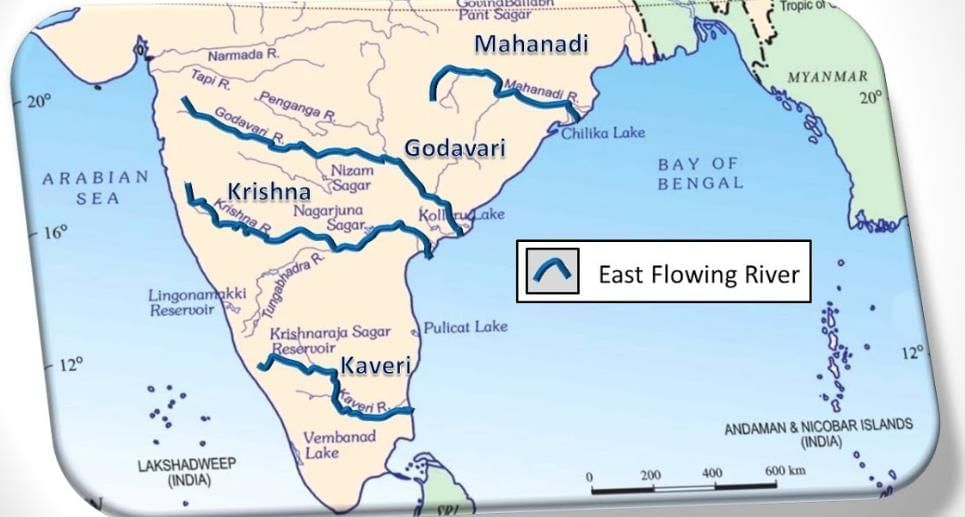 East Flowing Rivers
Let's Revise: How is the West Coast of India different from the East Coast?
View Answer Indian Islands
India has two major island groups: Lakshadweep in the Arabian Sea and Andaman and Nicobar Islands in the Bay of Bengal.
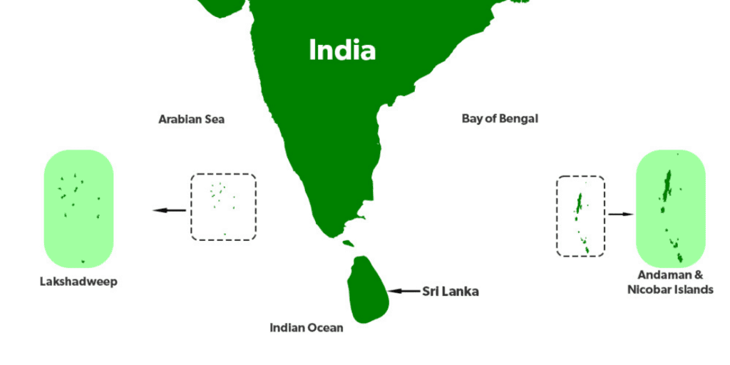 Islands of India
- An archipelago of 36 coral islands near Kerala, not all inhabited.
- Supports fishing and environmental protection.
- Over 500 volcanic islands, divided into Andaman and Nicobar groups.
- Home to coral reefs, beaches, jungles, and ancient tribes.
- Barren Island has India’s only active volcano, which sometimes erupts.
- Their location is strategically important, with a naval dock nearby.
The Delta in West Bengal and the Sundarbans
The Sundarbans is in the delta of the Ganga, Brahmaputra, and their tributaries, split between India and Bangladesh.
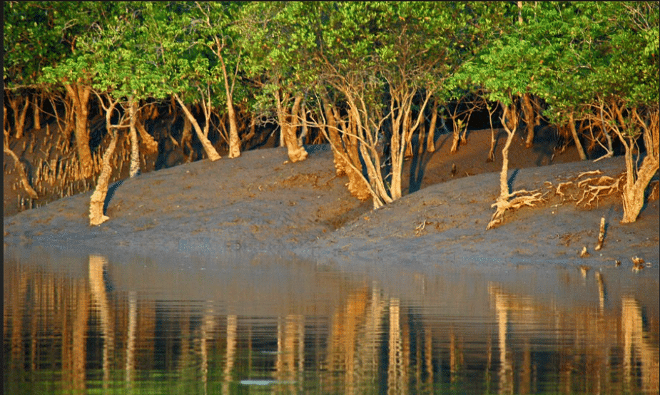 Mangroves
- It is a UNESCO World Heritage Site with a unique mix of river, sea, and land.
- The delta has mangroves and is home to the Royal Bengal Tiger and other species.
The Hills of the Northeast
The Northeast hills, part of the Meghalaya Plateau, include the Garo, Khasi, and Jantia hills.
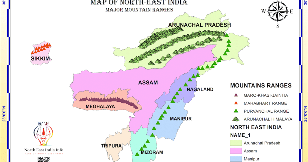 Hills of North- East
- Known for lush greenery, heavy rainfall, and waterfalls like the Seven Sisters Waterfalls.
- The region has some of the highest rainfall in the world, supporting forests, wildlife, and fertile land.
- Mawlynnong Village in the East Khasi Hills is called the cleanest village in Asia, famous for its living root bridges made by weaving tree roots.
- The Shad Suk Mynsiem festival celebrates nature and is held by the Khasi people.
Let's Revise
Q: What makes the Andaman and Nicobar Islands special?
View Answer View Answer Points to Remember
- India as a Mini-Continent:
India is often referred to as a mini-continent due to its diverse geographical features, which include:
Himalayas
Plains
Deserts
Plateaus
Coasts
Islands
The Himalayas – The Water Tower of Asia:
The Himalayas are often called the ‘Water Tower of Asia’ because they feed major rivers like the Ganga, Indus, and Brahmaputra, providing water for millions of people in the region.
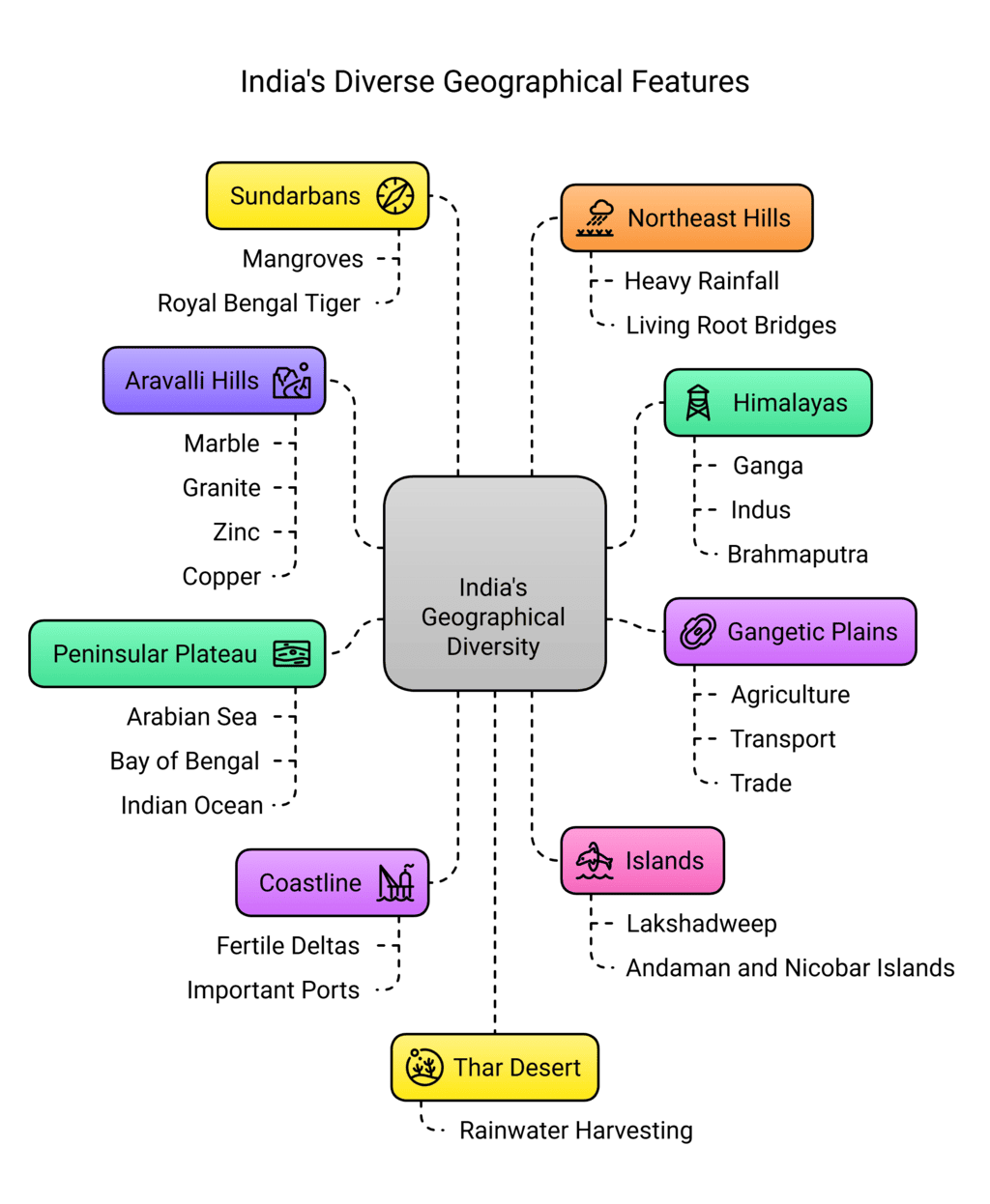
The Gangetic Plains – Fertility and Population:
The Gangetic Plains are incredibly fertile, supporting a large portion of India’s population. The rivers in these plains are crucial for:
Agriculture
Transport
Trade
Adapted Lifestyles in the Thar Desert:
In the Thar Desert, people have developed unique adapted lifestyles to survive harsh conditions. One such adaptation is rainwater harvesting to save water, which is a scarce resource in the region.The Aravalli Hills – Natural Barrier and Rich Minerals:
The Aravalli Hills prevent the Thar Desert from expanding further. They are also rich in minerals, including marble, granite, zinc, and copper, which have supported mining activities for centuries.Peninsular Plateau – Surrounded by Water:
The Peninsular Plateau is surrounded by water on three sides:
Arabian Sea (west)
Bay of Bengal (east)
Indian Ocean (south)
It is bordered by the Western Ghats and Eastern Ghats, and the rivers flowing through this region support farming and hydroelectric power generation.
India’s Coastline – Fertile Deltas and Important Ports:
India’s coastline, stretching over 7,500 km, is dotted with fertile deltas and important ports, which are crucial for trade and economic activities.Lakshadweep and Andaman and Nicobar Islands – Unique Wildlife and Coral Reefs:
Lakshadweep: A coral island group located near Kerala, known for its marine resources and environmental protection efforts.
Andaman and Nicobar Islands: Famous for their unique wildlife, coral reefs, and volcanic activity, these islands are an important part of India’s biodiversity.
The Sundarbans – UNESCO World Heritage Site:
The Sundarbans are a UNESCO World Heritage Site known for their mangroves and the Royal Bengal Tiger. This unique delta region, located in the lower Ganga-Brahmaputra delta, is a biodiversity hotspot.The Northeast Hills – Heavy Rainfall and Living Root Bridges:
The Northeast hills of India, part of the Meghalaya Plateau, experience some of the highest rainfall in the world.
This region is also known for its living root bridges, a unique feature created by weaving tree roots over time.
Difficult Words
- Subcontinent: A large part of a continent, like India and its neighbors.
- Landforms: Natural features of the Earth, like mountains, plains, and plateaus.
- Biodiversity: The variety of plants and animals in an area.
- Tributaries: Smaller rivers that flow into a larger river.
- Glacier: A large mass of ice that moves slowly.
- Plateau: A flat, elevated landform with steep slopes.
- Peninsula: Land surrounded by water on three sides.
- Estuaries: Areas where rivers meet the sea, mixing fresh and saltwater.
- Deltas: Triangular landforms formed by river sediments at the mouth.
- Archipelago: A group of islands.
- Mangroves: Trees that grow in coastal areas with roots in water.
FAQs on Geographical Diversity of India Class 7 Notes Social Science Chapter 1 Free PDF
| 1. What are the main geographical features of India? |  |
| 2. How were the Himalayas formed? | |
| 3. What is the significance of the Gangetic Plains in India? | |
| 4. What are the characteristics of the Great Indian Desert? | |
| 5. What types of islands are found in India? | |


shortcuts and tricks
,MCQs
,Summary
,ppt
,Free
,study material
,Extra Questions
,Objective type Questions
,Previous Year Questions with Solutions
,Geographical Diversity of India Class 7 Notes Social Science Chapter 1 Free PDF
,Viva Questions
,Important questions
,practice quizzes
,Sample Paper
,Semester Notes
,past year papers
,Geographical Diversity of India Class 7 Notes Social Science Chapter 1 Free PDF
,Geographical Diversity of India Class 7 Notes Social Science Chapter 1 Free PDF
,mock tests for examination
,Exam
,video lectures
;


Chapter Notes: Geographical Diversity of India Free PDF Download
Importance of Chapter Notes: Geographical Diversity of India
Chapter Notes: Geographical Diversity of India
Chapter Notes: Geographical Diversity of India Class 7 Questions
Study Chapter Notes: Geographical Diversity of India on the App
|
© EduRev
|
Education Revolution
|


|


within 7 days!