Geographic Data Chapter Notes | AP Human Geography - Grade 9 PDF Download
| Table of contents |
|
| Introduction |
|
| Geographic Data |
|
| Global Positioning System (GPS) |
|
| Remote Sensing |
|

Introduction
This chapter notes delves into geographic data, which encompasses information tied to specific locations on Earth’s surface. It covers the types of geographic data, such as place names, terrain features, land use patterns, and population statistics, and explores their applications in fields like urban planning and environmental management. The chapter also highlights geospatial technologies like GIS, GPS, and remote sensing, emphasizing their role in analyzing and visualizing spatial relationships.
Geographic Data
Geographic data refers to any information linked to a particular location on the Earth’s surface. It includes a broad array of details, such as coordinates (latitude and longitude), place names, addresses, physical terrain characteristics, land use configurations, demographic statistics, and various other data types.
Names of Places
- Place names are assigned to numerous types of locations, including urban centers, rural settlements, geographic regions, nations, and natural landmarks.
- Below are examples of different categories of place names:
- Cities: Examples include New York, London, Paris, Rome, and Tokyo.
- Towns: Examples include Millville, Maplewood, and Westfield.
- Villages: Examples include Hogsmeade, Twin Peaks, and Bon Temps.
- Regions: Examples include the Southwest, the Midwest, and the Deep South.
- Countries: Examples include the United States, Canada, Brazil, and Australia.
- Natural Features: Examples include Mount Everest, the Grand Canyon, and the Amazon River.
Terrain Features
- Terrain features are the natural physical attributes of the Earth’s surface, such as mountains, valleys, rivers, lakes, and oceans.
- Below are descriptions and examples of common terrain features:
- Mountains: These are prominent landforms that rise significantly above surrounding areas, formed through geological processes like tectonic activity or erosion. Examples include the Rocky Mountains, the Himalayas, and Mount Everest.
- Valleys: These are low-lying areas bordered by higher terrain, such as mountains or hills, created through processes like erosion or tectonic shifts. Examples include the Grand Canyon, the Shenandoah Valley, and the Rift Valley.
- Rivers: These are natural streams of water flowing from higher to lower elevations, typically sourced from rainwater or snowmelt, used for transportation, irrigation, and potable water. Examples include the Amazon, the Nile, and the Mississippi.
- Lakes: These are bodies of standing water encircled by land, formed by glacial activity, river erosion, or damming. Examples include Lake Superior, Lake Baikal, and Lake Victoria.
- Oceans: These are expansive saltwater bodies covering most of Earth’s surface, supporting diverse marine life and serving as vital resources for transportation, recreation, and food. Examples include the Atlantic Ocean, the Pacific Ocean, and the Indian Ocean.
Land Use Patterns
- Land use patterns describe how land is utilized or managed within a given area.
- Examples of common land use patterns include:
- Agricultural: Land dedicated to crop cultivation or livestock rearing is classified as agricultural. This includes traditional farmland as well as areas for specialty crops like vineyards or orchards.
- Residential: Land allocated for housing purposes is considered residential, encompassing single-family homes, apartments, and other dwelling types.
- Commercial: Land used for business activities is classified as commercial, including retail stores, office buildings, and other commercial developments.
- Industrial: Land designated for manufacturing or industrial activities is considered industrial, such as factories, warehouses, and other industrial facilities.
- Natural: Land preserved in its natural state or used for conservation or recreational purposes is classified as natural, including parks, forests, or wildlife habitats.
Population Statistics
- Population statistics are numerical data that characterize a population’s attributes, such as size, age, gender, and other demographic factors.
- Examples of population statistics include:
- Total Population: The total number of individuals residing in a specific area, such as a city, state, or country.
- Population Density: A measure of the number of people living in a given area, typically expressed as people per square mile or square kilometer.
- Age Structure: The distribution of a population across different age groups, such as children, working-age adults, and seniors.
- Gender Ratio: The proportion of males to females within a population.
- Birth Rate: The number of live births per 1,000 individuals in a population annually.
- Death Rate: The number of deaths per 1,000 individuals in a population annually.
- Life Expectancy: The average number of years a person is expected to live within a given population.
- Geographic data is significant because it provides insights into the location and characteristics of Earth’s surface features. This information supports numerous applications, including transportation, urban planning, environmental management, and natural resource management.
- Geographic data enables the creation of maps, which are essential for visualizing and interpreting spatial relationships and patterns. It also facilitates the analysis of the distribution and movement of people, animals, and other phenomena across the Earth’s surface.
- Additionally, geographic data aids in making informed decisions about resource use and management, such as identifying areas prone to natural disasters or suitable for agriculture or urban development.
- When planning a road trip, how do you find your way? Do you rely on a collection of paper roadmaps, or do you use Google Maps on your smartphone? Likely, it’s the latter. This prompts the question: what geospatial technologies are available to us?
- Perhaps you have a pile of roadmaps in your car for road trips—just kidding! You probably use Google Maps on your phone. What are the geospatial technologies we can access?
- Global Positioning System (GPS): Utilized for navigation, it provides precise location data relative to surrounding areas and destinations.
- Remote Sensing: Satellites orbiting Earth collect and transmit data back to the surface.
- Geographic Information System (GIS): A computer system that organizes location-based information in “layers.”
Geographic Information Systems (GIS)
- Geographic data is frequently collected and managed using Geographic Information Systems (GIS), specialized software tools that enable users to map, analyze, and visualize spatial data. GIS supports a wide range of applications, including environmental studies, transportation planning, public health, and natural resource management.
- GIS is crucial because it integrates diverse data types and analyzes them in the context of their geographic locations, enhancing understanding of relationships between phenomena and their surroundings.
- Examples of GIS applications include:
- Urban Planning: GIS creates maps and analyzes data on land use, population density, and transportation networks, aiding city planners in making informed land development decisions.
- Environmental Management: GIS maps and analyzes data on natural resources like water, forests, and wildlife, supporting resource monitoring, management, and conservation decisions.
- Disaster Response: GIS maps and analyzes data related to natural disasters like earthquakes, hurricanes, and floods, assisting emergency responders and government agencies in planning and coordinating response and recovery efforts.
- Agriculture: GIS maps and analyzes data on crop production and soil conditions, helping farmers optimize resource use and make informed land management decisions.
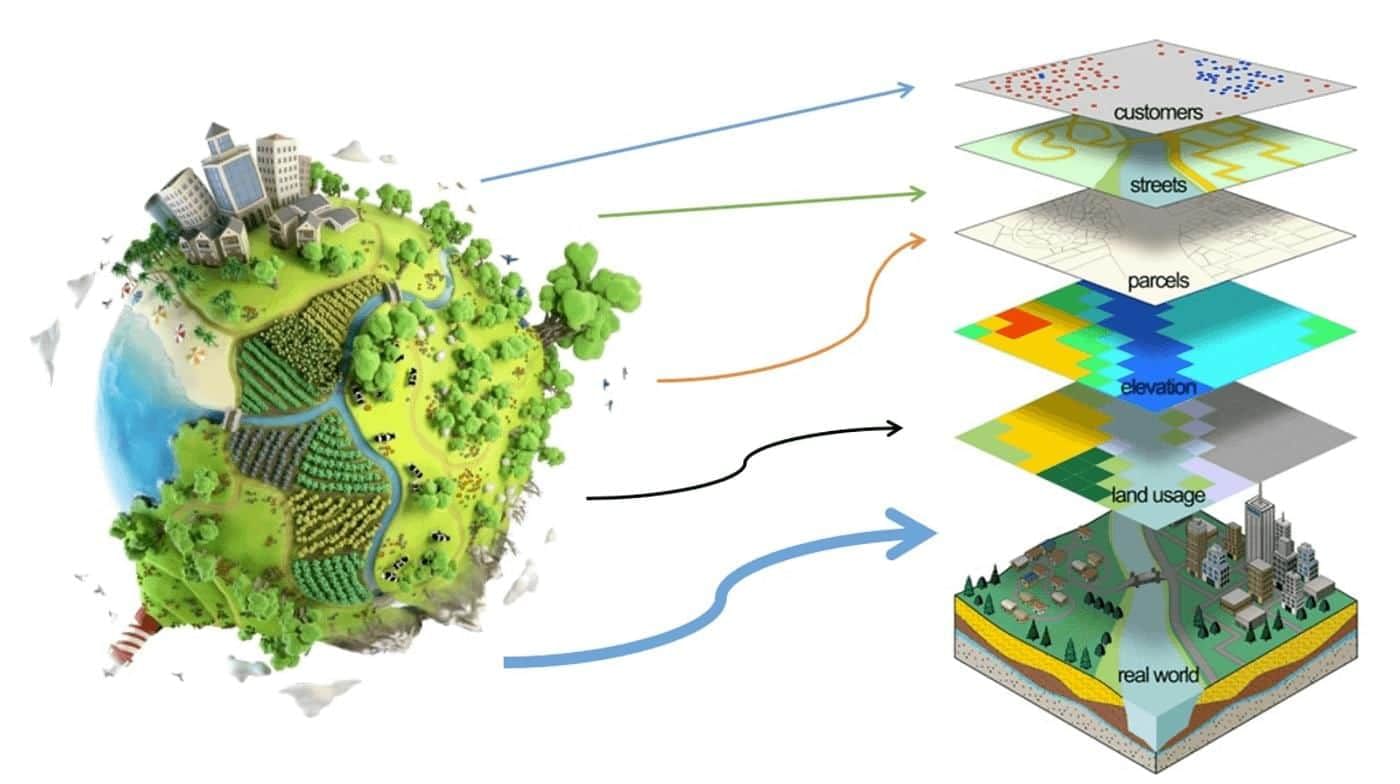
GIS World Model
A layer in GIS represents a distinct piece of human or environmental information, such as cities, highways, landforms, or fast food restaurants.
Global Positioning System (GPS)
- The Global Positioning System (GPS) is a satellite-based navigation system that allows users to determine their exact location, speed, and time anywhere on Earth. It operates by receiving signals from orbiting satellites to calculate the user’s position. GPS is widely used in applications like transportation, mapping, and location-based services.
- GPS data is a form of geographic data collected using GPS technology, including coordinates (latitude and longitude), altitude, speed, and time. It is often combined with other geographic data, such as maps, aerial imagery, or geospatial databases, to produce comprehensive and accurate representations of Earth’s surface.
- GPS data supports numerous applications, including navigation and location-based services like map apps and ride-sharing platforms. It is also utilized in surveying, agriculture, and environmental management to map and monitor landscape and resource changes.
- Beyond practical uses, GPS has significantly influenced the development of new technologies and industries, such as location-based services like map apps and ride-sharing, which have transformed how we navigate and interact with our environment.
- Examples of GPS applications include:
- Navigation: GPS is widely used in navigation devices like car GPS systems and smartphone apps, providing turn-by-turn directions and locating nearby points of interest, such as gas stations or restaurants.
- Transportation: GPS supports fleet management, asset tracking, and public transit by monitoring the location and movement of buses, trucks, or delivery vehicles and optimizing routes and schedules.
- Agriculture: GPS aids precision agriculture by helping farmers optimize resources like water, fertilizers, and pesticides through field mapping and equipment tracking.
- Environmental Management: GPS maps and monitors natural resources like forests, wetlands, and wildlife habitats, tracks animal movements, and monitors environmental conditions such as air and water quality.
Remote Sensing
- Geographic data is often paired with remote sensing, the process of collecting data about Earth’s surface using satellite or aerial imagery. These technologies together enhance understanding of spatial patterns and relationships, supporting informed decision-making.
- Remote sensing is particularly valuable in scenarios where ground-based data collection is challenging, such as remote or hazardous areas, or for monitoring changes over time through regular imagery collection.
- Remote sensing is applied in fields like environmental monitoring, land use mapping, and natural resource management, providing critical insights into Earth’s surface processes.
- Examples of remote sensing applications include:
- Monitoring Land Use and Land Cover: Remote sensing maps and tracks changes in land use and cover, aiding in understanding human impacts on landscapes and informing land management and conservation decisions.
- Mapping and Monitoring Natural Resources: Remote sensing maps resources like forests, crops, water bodies, and minerals, supporting decisions on their use and conservation.
- Disaster Response: Remote sensing quickly assesses damage from natural disasters like earthquakes, hurricanes, and floods, aiding emergency responders and government agencies in planning response and recovery efforts.
- Environmental Monitoring: Remote sensing tracks environmental conditions like air and water quality and monitors ecosystem health, informing decisions on protecting and conserving natural resources.
Key Terms
- Agriculture: The practice of cultivating soil, growing crops, and raising livestock for food, fiber, and other products essential for human sustenance and economic stability, influencing settlement, trade, and environmental patterns.
- Disaster Response: Organized efforts to address the immediate consequences of disasters, providing emergency services and coordinating resources to mitigate impacts and support recovery, relying heavily on geographic data for effective planning.
- Environmental Management: The process of managing human interactions with the environment to ensure sustainability and responsible resource use, utilizing geographic data for informed decision-making and conservation strategies.
- Geographic Data: Information associated with specific locations on Earth’s surface, encompassing quantitative and qualitative data used to analyze spatial relationships and patterns in fields like urban planning and environmental science.
- Geographic Information System (GIS): A specialized tool for capturing, storing, analyzing, and visualizing geographic data, enabling insights into spatial relationships for applications in urban planning, environmental management, and public health.
- Geospatial Technologies: Tools and methods for collecting, analyzing, and visualizing spatial data, integrating GIS, remote sensing, and GPS to understand complex spatial patterns and support decision-making in various fields.
- Global Positioning System (GPS): A satellite-based navigation system providing precise location, speed, and time data globally, essential for navigation, transportation, and environmental management applications.
- Land Use Patterns: The organization and utilization of land for purposes like agriculture, residential, commercial, and industrial activities, shaped by geographic, economic, and social factors, critical for urban planning and resource management.
- Names of Places: Toponyms, or labels for geographic locations, carrying cultural, historical, or geographic significance, aiding in the identification and connection to various regions worldwide.
- Navigation: The process of planning and controlling movement from one location to another, determining position and course, essential for efficient travel using tools like maps, GPS, and compasses.
- Population Statistics: Quantitative data on population size, distribution, density, and demographics, vital for understanding trends and informing decisions on resource allocation, urban planning, and social services.
- Remote Sensing: The technique of collecting data about Earth’s surface from a distance, typically via satellites or aircraft, enhancing analysis of land use, environmental changes, and urban development for decision-making.
- Terrain Features: Physical characteristics of Earth’s surface, such as mountains, valleys, and rivers, influencing climate, human activity, and ecosystems, critical for understanding landscape impacts on settlement and land use.
- Transportation: The movement of people, goods, and services across various modes like road, rail, air, and water, connecting places and driving economic development and urban planning.
- Urban Planning: The design and management of land use in urban areas to create sustainable, functional, and aesthetically pleasing communities, balancing social, economic, and environmental goals for long-term growth.
FAQs on Geographic Data Chapter Notes - AP Human Geography - Grade 9
| 1. What are the major geographic spatial concepts that geographers use to analyze regions? |  |
| 2. How do geographers define regions, and what are the types of regions they identify? | |
| 3. What is the significance of scale in geographic analysis? | |
| 4. How does time and distance impact geographic understanding and analysis? | |
| 5. In what ways do theories of human-environment interaction shape geographic studies? | |


video lectures
,Objective type Questions
,practice quizzes
,study material
,ppt
,Geographic Data Chapter Notes | AP Human Geography - Grade 9
,Viva Questions
,Sample Paper
,past year papers
,mock tests for examination
,Previous Year Questions with Solutions
,Geographic Data Chapter Notes | AP Human Geography - Grade 9
,Summary
,MCQs
,Geographic Data Chapter Notes | AP Human Geography - Grade 9
,Exam
,shortcuts and tricks
,Semester Notes
,Extra Questions
,Free
,Important questions
;


Chapter Notes: Geographic Data Free PDF Download
Importance of Chapter Notes: Geographic Data
Chapter Notes: Geographic Data
Chapter Notes: Geographic Data Grade 9 Questions
Study Chapter Notes: Geographic Data on the App
|
© EduRev
|
Education Revolution
|


|


