Class 8 Exam > Class 8 Notes > Chapter Notes: India - Physiography
India - Physiography Chapter Notes - Class 8 PDF Download
| Table of contents |
|
| Introduction |
|
| Location and Extent of India |
|
| Boundaries of India |
|
| Political Divisions |
|
| Physiographic Features of India |
|

Introduction
India is a land of diverse geographical features, shaped by its unique geological history as part of the ancient Gondwanaland. This chapter explores India’s physiography, including its location, boundaries, political divisions, and varied physical regions like mountains, plains, plateaus, deserts, coastal areas, and islands. Learn how these features influence climate, time differences, and the country’s rich biodiversity and resources.Physiography
- India’s geological past traces back to Gondwanaland, an ancient landmass.
- About 50 million years ago, it separated and collided with the Tibetan landmass.
- This collision formed the Himalayas, known as young fold mountains.
- India ranks as the seventh largest country globally by area.
Location and Extent of India
- India is fully located in the Northern and Eastern Hemispheres.
- Mainland India spans latitudes 8°4’N to 37°6’N and longitudes 68°7’E to 97°25’E.
- Indira Point, the southernmost tip, lies at 6°45’N in the Andaman and Nicobar Islands.
- The Tropic of Cancer (23°30’N) splits India into nearly two equal parts.
- Both east-west and north-south extents are around 3,000 kilometers.
- A two-hour time lag exists between the eastern and western ends due to longitudinal stretch.
- India’s standard time follows the 82°30’E longitude, called the Standard Meridian, passing through Prayagraj, Uttar Pradesh.
- Latitudinal extent affects day and night duration across the country.
Implications of Latitudinal Extensions
- The Tropic of Cancer divides India into two zones.
- The southern half, in the tropical zone, has warm, tropical climate with no distinct winter.
- The northern half, in the subtropical zone, experiences hot summers and cold winters.
- Temperature decreases as latitude increases, varying from warm Kerala to cold Kashmir.
- Day and night duration differs greatly: Kanyakumari has nearly equal day and night.
- Kashmir, far from the equator, sees a difference of almost 5 hours.
- Regions farther from the equator get uneven sunlight, affecting day-night lengths.
Boundaries of India
- Afghanistan and Pakistan border India to the northwest.
- China, Bhutan, and Nepal are northeastern neighbors.
- The Chinese border runs from Jammu and Kashmir to Arunachal Pradesh, touching Himachal Pradesh, Uttarakhand, and Sikkim.
- Bangladesh lies to the east, and Myanmar to the far east.
- Sri Lanka is separated by the Palk Strait and Gulf of Mannar.
- Maldives, an island neighbor, lies to the southwest.
- The Himalayas bound India on the northern and northeastern sides.
Political Divisions
- India, a vast nation, has 28 states and 9 union territories.
- States and territories are grouped into zones based on location.
Zones and States/Union Territories
- Northwestern India: Chandigarh, Haryana, Himachal Pradesh, Jammu and Kashmir, Ladakh, Punjab
- Northern India: Delhi, Uttar Pradesh, Uttarakhand
- Western India: Dadra and Nagar Haveli, Daman and Diu, Gujarat, Maharashtra, Rajasthan
- Central India: Madhya Pradesh, Chhattisgarh
- Eastern India: Bihar, Jharkhand, Odisha, Sikkim, West Bengal
- Northeastern India: Arunachal Pradesh, Assam, Manipur, Meghalaya, Mizoram, Nagaland, Tripura
- Southern India: Andhra Pradesh, Goa, Karnataka, Kerala, Puducherry, Tamil Nadu
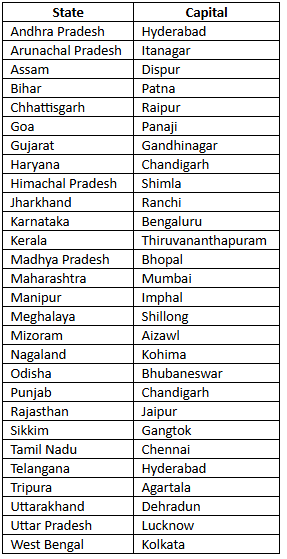
State and Capitals
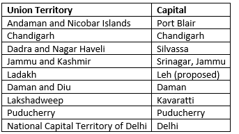
Union Territories and Capitals
Physiographic Features of India
- India boasts diverse physical features, from lofty mountains to flat plains.
- Six main divisions exist based on physical characteristics.
- Divisions: Northern Mountains, Northern Plains, Peninsular Plateau, Great Indian Desert, Coastal Plains, Islands
Northern Mountains
- The Himalayas, the highest range, mean "abode of snow" in Sanskrit.
- They span 2,500 kilometers from the Pamir Knot to Purvanchal.
- Width varies: 400 kilometers in the west, narrowing to 150 kilometers in the east.
- Formed of sedimentary rocks, they are young fold mountains.
- Three parallel ranges: Himadri, Himachal, and Sivalik.
Greater Himalayas or Himadri
- Northernmost range with an average height of 6,000 meters.
- Width ranges from 120 to 190 kilometers.
- A continuous range with peaks over 8,000 meters: Mt Everest (Nepal), Kanchenjunga, Makalu, Dhaulagiri, Nanga Parbat.
- Peaks are mostly on borders and perennially snow-covered.
- High passes include Rohtang, Bara-lacha La, Shipki La, and Zoji La.
Lesser Himalayas or Himachal
- Lies south of Himadri, with altitudes of 1,000 to 4,500 meters.
- Average width is 50 kilometers.
- Includes ranges like Pir Panjal, Dhaula Dhar, and Mahabharata.
- Popular hill stations: Manali, Kullu, Dalhousie, Mussoorie, Shimla, Nainital, Darjeeling.
- These are easily accessible and attract tourists.
Outer Himalayas or the Sivaliks
- Outermost range with altitudes of 900 to 1,100 meters.
- Width varies from 10 to 50 kilometers.
- Hills are narrow, discontinuous, and merge with other ranges.
- Valleys between Sivaliks and Himachal are called Duns, e.g., Dehradun, Kotlidun, Patlidun.
- Terai, a densely forested and marshy region, lies at the foothills.
The Purvanchal Range
- Located along the India-Myanmar border in the east.
- Average altitude is below 3,000 meters.
- Northern part: Patkai Bum, Naga Hills.
- Southern part: Lushai Hills, Mizo Hills.
- In Meghalaya: Garo Hills, Khasi Hills, Jaintia Hills.
The Karakoram Range
- Found north of the Himalayas in Kashmir.
- Lies on the border of India, Pakistan, China, and extends to Afghanistan and Tajikistan.
- Has peaks over 8,000 meters, mostly outside India.
The importance of the Himalayas to India is listed below:
- Shields India from cold northeastern trade winds from Tibet.
- Guides monsoon winds for rainfall.
- Rich in resources and biodiversity.
- A major tourist attraction.
- Source of key rivers.
Northern Plains
- Also called Gangetic Plains, located south of the Himalayas and north of the Peninsular Plateau.
- Formed by alluvial deposits from the Indus, Ganga, and Brahmaputra rivers.
- Spans 2,400 kilometers and is densely populated.
- Very fertile, supporting crops like wheat, rice, sugarcane, pulses, oilseeds, and jute.
- Divided into Western Plain and Ganga-Brahmaputra Plain.
- Western Plain
- Formed by the Indus and tributaries: Jhelum, Chenab, Ravi, Beas, Sutlej.
- Jhelum and Chenab flow through Jammu and Kashmir.
- Ravi, Beas, and Sutlej cross the Punjab-Haryana plains.
- Much of this plain lies in Pakistan.
- Doabs, land between converging rivers, are found in Punjab.
- Ganga-Brahmaputra Plain
- Formed by sediments from the Ganga and Brahmaputra rivers.
- The Ganga’s key tributary is the Yamuna, both originating in the Himalayas.
- The Brahmaputra, called Tsangpo in Tibet, flows east, then south and west through Assam.
- Ganga Plain stretches between Ghaggar and Teesta rivers.
- Brahmaputra Plain forms the eastern part.
- Both rivers meet as the Padma in Bangladesh, creating the world’s largest delta.
The importance of the Northern Plains is listed below:
- Fertile soil and water resources make it ideal for agriculture, known as India’s granaries.
- Flat land, slow rivers, and good climate boost economic and social growth.
- Strong road and rail networks support large-scale industrialization.
Peninsular Plateau
- Largest and oldest hard rock formation, triangular in shape.
- Part of ancient Gondwanaland.
- Divided into Central Highlands and Deccan Plateau.
Central Highlands
- Stretches from the Narmada River to the Northern Plains.
- Bounded by Aravallis in the west and Satpura range in the south.
- Eastern part includes Rajmahal hills.
- Includes Malwa and Chhota Nagpur Plateaus.
- Rivers: Betwa, Chambal, Ken flow through Malwa.
- Hills: Mahadeo, Kaimur, Maikal in Chhota Nagpur.
Deccan Plateau
- Separated from Chhota Nagpur by a geological fault.
- Deccan Trap, a black soil area, formed by volcanic eruptions, suits cotton and sugarcane.
- Divided into Western Ghats and Eastern Ghats.
- Western Ghats
- A mountain range along the western coast, also called Sahyadri.
- Continuous, crossed only via passes like Thal Ghat, Bhor Ghat, and Pal Ghat.
- Highest peak: Anamudi (2,695 meters).
- Famous waterfalls: Jog Falls (Sharavati River), Shivasamudram Falls (Kaveri River).
- Eastern Ghats
- Discontinuous, low mountain ranges along the eastern coast.
- Run from south of Mahanadi Valley to Nilgiri Hills.
- Highest peak: Mahendragiri (1,501 meters).
- Drained by Mahanadi, Godavari, Krishna, and Kaveri rivers.
- Nilgiri Hills link Western and Eastern Ghats in the south.
The Great Indian Desert
- Also known as the Thar Desert, lies northwest of Aravalli Hills.
- Receives less than 150 millimeters of rain yearly, making it dry.
- A region of inland drainage with Luni as the main river.
- Other streams appear during the rainy season.
- Contains salt lakes, with Sambhar Lake being the largest.
- Features crescent-shaped dunes called barchans.
Coastal Plains
- Run parallel to the Arabian Sea and Bay of Bengal.
- Divided into Western and Eastern Coastal Plains.
- Western Coastal Plain
- Extends from Rann of Kutch (Gujarat) to Kanyakumari (Tamil Nadu).
- Divisions: Kutch and Kathiawar Coast (Gujarat), Konkan Coast (Maharashtra), Goan Coast (Goa and Karnataka), Malabar Coast (Kerala).
- Narrow in the middle, wider in the north and south.
- Rivers here do not form deltas.
- Eastern Coastal Plain
- Runs along the Bay of Bengal, broader than the western coast.
- An emergent plain with fewer ports and harbors.
- Has well-developed deltas from Mahanadi, Godavari, Krishna, and Kaveri rivers.
Islands
There are two major island groups in India— the Andaman and Nicobar Islands in the Bay of Bengal and the Lakshadweep Islands in the Arabian Sea.- Andaman and Nicobar Islands
- Located in the Bay of Bengal, with 204 islands.
- Main groups: Ritchie’s Archipelago, Labyrinth Islands.
- Barren Island hosts Barren Volcano, an active volcano.
- Ten Degree Channel separates Andaman and Nicobar Islands.
- Lakshadweep Islands
- Found in the Arabian Sea, near the Malabar Coast of Kerala.
- Consist of 43 coral-formed islands.
- Rich in diverse flora and fauna.
- Minicoy is the largest island.
FAQs on India - Physiography Chapter Notes - Class 8
| 1. What are the major geographical features of India? |  |
Ans. India is characterized by diverse geographical features including the Northern Mountains, the Indo-Gangetic Plain, the Peninsular Plateau, the Coastal Plains, and the Thar Desert. The Northern Mountains include the Himalayas, which are the highest mountain range in the world, while the Indo-Gangetic Plain is known for its fertile land.
| 2. What are the boundaries of India? | |
Ans. India is bounded by several countries and geographical features. To the north, it shares boundaries with China, Nepal, and Bhutan. To the west, it is bordered by Pakistan. To the east, it shares borders with Bangladesh and Myanmar. The southern boundary is surrounded by the Indian Ocean, with the Arabian Sea to the southwest and the Bay of Bengal to the southeast.
| 3. How is India politically divided? | |
Ans. India is divided into 28 states and 8 Union territories. Each state has its own government, while the Union territories are governed directly by the Central Government. The political divisions are based on various factors such as language, culture, and historical significance.
| 4. What is the significance of the Northern Mountains in India? | |
Ans. The Northern Mountains, particularly the Himalayas, play a crucial role in India's climate and ecology. They act as a barrier to cold winds from Central Asia, thus influencing the monsoon patterns in the Indian subcontinent. They are also vital for biodiversity and are home to numerous rivers that originate from these mountains.
| 5. What is the extent of India in terms of area and population? | |
Ans. India covers an area of approximately 3.287 million square kilometers, making it the seventh-largest country in the world. As of recent estimates, India has a population of over 1.4 billion people, making it the second-most populous country after China.
About this Document

4.75/5
Rating

Oct 09, 2025
Last updated
Related Exams
Document Description: Chapter Notes: India - Physiography for Class 8 2025 is part of Class 8 preparation. The notes and questions for Chapter Notes: India - Physiography have been prepared according to the Class 8 exam syllabus. Information about Chapter Notes: India - Physiography covers topics like Introduction, Location and Extent of India, Boundaries of India, Political Divisions, Physiographic Features of India and Chapter Notes: India - Physiography Example, for Class 8 2025 Exam. Find important definitions, questions, notes, meanings, examples, exercises and tests below for Chapter Notes: India - Physiography.
Introduction of Chapter Notes: India - Physiography in English is available as part of
our Class 8 preparation & Chapter Notes: India - Physiography in Hindi for Class 8
courses. Download more important topics, notes, lectures and mock test series for Class 8
Exam by signing up for free. Class 8: India - Physiography Chapter Notes - Class 8
Description
Full syllabus notes, lecture & questions for India - Physiography Chapter Notes - Class 8 - Class 8 | Plus excerises question with solution to help you revise complete syllabus | Best notes, free PDF download
Information about Chapter Notes: India - Physiography
In this doc you can find the meaning of Chapter Notes: India - Physiography defined & explained in the simplest way possible.
Besides explaining types of Chapter Notes: India - Physiography theory,
EduRev gives you an ample number of questions to practice Chapter Notes: India - Physiography tests, examples and also practice Class 8 tests.
Related Searches
India - Physiography Chapter Notes - Class 8
,Extra Questions
,Previous Year Questions with Solutions
,study material
,India - Physiography Chapter Notes - Class 8
,mock tests for examination
,Important questions
,video lectures
,past year papers
,practice quizzes
,Sample Paper
,Viva Questions
,Summary
,Semester Notes
,Objective type Questions
,Exam
,Free
,India - Physiography Chapter Notes - Class 8
,ppt
,shortcuts and tricks
,MCQs
;


Additional Information about Chapter Notes: India - Physiography for Class 8 Preparation
Chapter Notes: India - Physiography Free PDF Download
The Chapter Notes: India - Physiography is an invaluable resource that delves deep into the core of the Class 8 exam.
These study notes are curated by experts and cover all the essential topics and concepts, making your preparation more efficient and effective.
With the help of these notes, you can grasp complex subjects quickly, revise important points easily,
and reinforce your understanding of key concepts. The study notes are presented in a concise and easy-to-understand manner,
allowing you to optimize your learning process. Whether you're looking for best-recommended books, sample papers, study material,
or toppers' notes, this PDF has got you covered. Download the Chapter Notes: India - Physiography now and kickstart your journey towards success in the Class 8 exam.
Importance of Chapter Notes: India - Physiography
The importance of Chapter Notes: India - Physiography cannot be overstated, especially for Class 8 aspirants.
This document holds the key to success in the Class 8 exam.
It offers a detailed understanding of the concept, providing invaluable insights into the topic.
By knowing the concepts well in advance, students can plan their preparation effectively.
Utilize this indispensable guide for a well-rounded preparation and achieve your desired results.
Chapter Notes: India - Physiography
Chapter Notes: India - Physiography Notes offer in-depth insights into the specific topic to help you master it with ease.
This comprehensive document covers all aspects related to Chapter Notes: India - Physiography.
It includes detailed information about the exam syllabus, recommended books, and study materials for a well-rounded preparation.
Practice papers and question papers enable you to assess your progress effectively.
Additionally, the paper analysis provides valuable tips for tackling the exam strategically.
Access to Toppers' notes gives you an edge in understanding complex concepts.
Whether you're a beginner or aiming for advanced proficiency, Chapter Notes: India - Physiography Notes on EduRev are your ultimate resource for success.
Chapter Notes: India - Physiography Class 8 Questions
The "Chapter Notes: India - Physiography Class 8 Questions" guide is a valuable resource for all aspiring students preparing for the
Class 8 exam. It focuses on providing a wide range of practice questions to help students gauge
their understanding of the exam topics. These questions cover the entire syllabus, ensuring comprehensive preparation.
The guide includes previous years' question papers for students to familiarize themselves with the exam's format and difficulty level.
Additionally, it offers subject-specific question banks, allowing students to focus on weak areas and improve their performance.
Study Chapter Notes: India - Physiography on the App
Students of Class 8 can study Chapter Notes: India - Physiography alongwith tests & analysis from the EduRev app,
which will help them while preparing for their exam. Apart from the Chapter Notes: India - Physiography,
students can also utilize the EduRev App for other study materials such as previous year question papers, syllabus, important questions, etc.
The EduRev App will make your learning easier as you can access it from anywhere you want.
The content of Chapter Notes: India - Physiography is prepared as per the latest Class 8 syllabus.
|
© EduRev
|
Education Revolution
|


|


Signup to see your scores
go up
within 7 days!
within 7 days!
Takes less than 10 seconds to signup