Representation of Geographical Features Chapter Notes | Geography Class 6 ICSE PDF Download

Introduction
Maps are essential tools that help us understand and represent the world around us. Whether it’s locating a place, studying geographical features, planning infrastructure, or navigating routes, maps provide valuable visual information. This chapter explains how maps represent the Earth's surface and highlights their key elements and advantages. It also describes how maps differ from sketches, plans, and globes. It further covers scales, directions, conventional symbols, and how geographical features like rivers and mountains are depicted on maps.
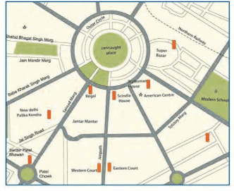
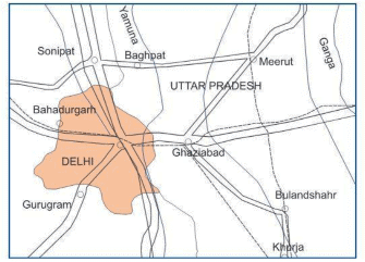
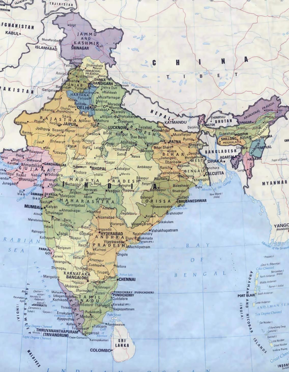 India's Map
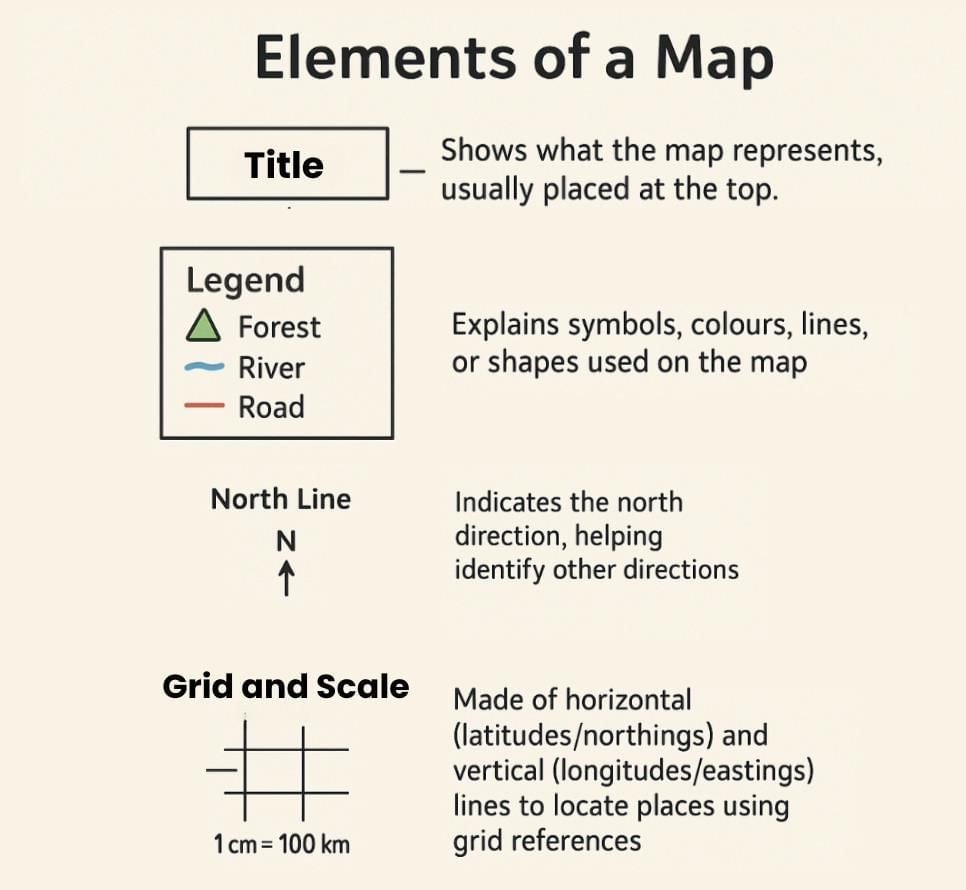
Elements of a Map
- Title: Shows what the map represents, usually placed at the top.
- Legend: Explains symbols, colours, lines, or shapes used on the map.
- Scale: Represents the ratio between map distance and actual ground distance (e.g., 1 cm = 100 km).
- North Line: Indicates the north direction, helping identify other directions.
- Grid: A network of horizontal lines (latitudes or northings) and vertical lines (longitudes or eastings) used to locate places on the map.
Advantages of Maps
- Maps are two-dimensional and can be easily folded, making them highly portable and convenient to carry.
- They show detailed layouts of cities, towns, roads, or streets, which is helpful for local planning and navigation.
- Maps provide more topographical information than globes, such as elevation, terrain, and land use.
- They are easier to create, modify, and update when physical or political boundaries change.
- Maps are useful tools for sailors, pilots, engineers, environmentalists, and government officials for purposes such as planning, administration, research, and defence.
Importance of Maps
- Represent the world on a smaller scale for easy understanding.
- Help in navigation from one place to another.
- Organise information about climate, agriculture, population, and other geographical factors.
- Assist in finding solutions by providing clear geographical data.
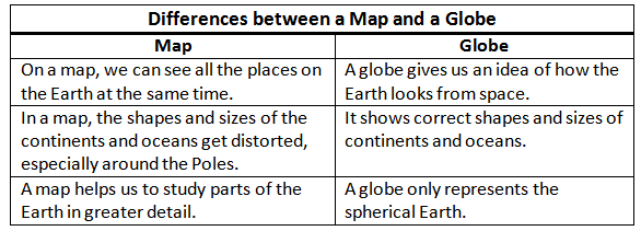
Map, Sketch, Plan, and Globe
- Map: A flat, graphical representation of the Earth or its parts using symbols.
- Sketch: A rough, freehand drawing of an area, showing main features without scale.
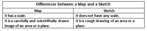
- Plan: A detailed drawing of a small area, drawn to scale using proper tools.
- Globe: A small, rotating model of the Earth showing latitudes and longitudes.
Scale
- Shows the ratio of map distance to actual ground distance.
- Found at the bottom of the map or below the legend.
- Used in maps, blueprints, and architectural models for accuracy.
Formulas:
- Map scale = Map distance ÷ Ground distance
- Map distance = Map scale × Ground distance
- Ground distance = Map distance ÷ Map scale
- Examples:
- Scale 1:25,000 means 1 cm = 250 m or 0.25 km.
- If the map distance is 10 cm, the real distance = 10 × 0.25 km = 2.5 km.
Types of Scales
Statement/Verbal Scale
- A scale written in words is called a statement or verbal scale.
- It tells how much distance on the map equals a distance in real life.
- Example: 1 cm on the map means 1 km in actual distance on land.
Representative Fraction or Ratio Scale
- A scale shown as a ratio or fraction is called a representative fraction (RF).
- It shows the ratio between the map distance and the real ground distance.
- The numerator is always 1, and the denominator shows the real distance.
- Example: RF = 1/1000000 means 1 unit on the map equals 1000000 units on the ground.
Maps on the Basis of Scale
Large-scale Maps: Show small areas with great detail (e.g., topographic or city street maps).
Small-scale Maps: Show large areas with less detail (e.g., maps of continents or the world).
Other Scales
- Vertical Scale: Used in aerial photos where the camera points downward for detailed views.
- Diagonal Scale: Measures very small distances (e.g., 0.1 mm) accurately.
Directions
- Directions help in locating places relative to one another.
- North is shown by an arrow marked “N” on maps.
- Cardinal Directions: North, East, South, West.
- Intermediate Directions: Northeast, Northwest, Southeast, Southwest.
Conventional Symbols
These are universally accepted signs used to represent various features on maps.
Types:
- Point Symbols: Show places like buildings, cities, or temples.
- Line Symbols: Show railways, roads, or rivers.
- Area Symbols: Show forests, orchards, or cultivation.
- Colours: Blue for water bodies, green for vegetation.
Representation of Geographical Features through Diagrams
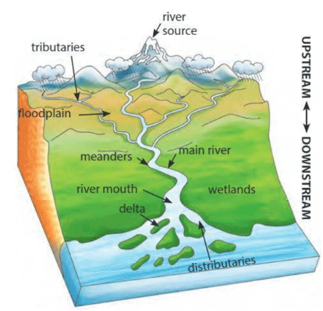
- River: Large freshwater streams flowing from high to low elevations.
- Meanders: Wide loops or bends formed when a river flows slowly through flat plains with more water and silt.
- Tributaries: Small rivers that flow into a larger river.
- Distributary: Small streams that break away from the main river and drain into the sea without rejoining.
- Delta: Triangular or fan-shaped areas at a river’s mouth filled with silt, e.g., Ganga-Brahmaputra Delta.
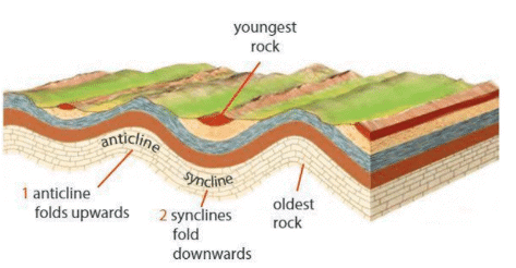
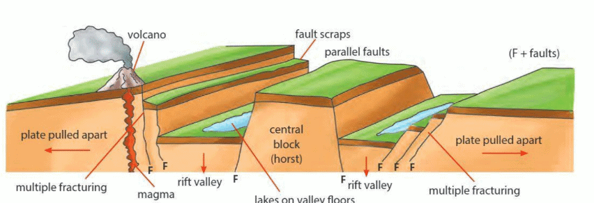
Landforms Formed by Folding and Faulting
Formed when Earth’s crust is compressed, creating folds.
- Anticline: Upward folds or crests of fold mountains.
- Syncline: Downward folds or troughs of fold mountains.
- Block Mountains: Formed when land between two faults is pushed upward due to compression.
- Rift Valley: Formed when land between faults sinks due to tension in the Earth's crust.
- Arch: A curved structure supporting weight above bridges, roofs, or walls.
|
12 videos|44 docs|7 tests
|
FAQs on Representation of Geographical Features Chapter Notes - Geography Class 6 ICSE
| 1. What are the main elements of a map? |  |
| 2. Why are maps important in our daily lives? | |
| 3. What is the difference between a map, a sketch, a plan, and a globe? | |
| 4. How do scales on maps work? | |
| 5. What are conventional symbols, and why are they used on maps? | |


Summary
,Important questions
,past year papers
,Viva Questions
,Exam
,practice quizzes
,MCQs
,Objective type Questions
,Representation of Geographical Features Chapter Notes | Geography Class 6 ICSE
,video lectures
,ppt
,mock tests for examination
,Extra Questions
,study material
,Free
,Representation of Geographical Features Chapter Notes | Geography Class 6 ICSE
,shortcuts and tricks
,Semester Notes
,Previous Year Questions with Solutions
,Representation of Geographical Features Chapter Notes | Geography Class 6 ICSE
,Sample Paper
;


Chapter Notes: Representation of Geographical Features Free PDF Download
Importance of Chapter Notes: Representation of Geographical Features
Chapter Notes: Representation of Geographical Features
Chapter Notes: Representation of Geographical Features Class 6 Questions
Study Chapter Notes: Representation of Geographical Features on the App
|
© EduRev
|
Education Revolution
|


|


within 7 days!