Class 7 Exam > Class 7 Notes > Geography Class 7 ICSE > Chapter Notes: Representation of Geographical Features
Representation of Geographical Features Chapter Notes | Geography Class 7 ICSE PDF Download
| Table of contents |
|
| Introduction |
|
| Topographical Maps |
|
| Use of Colours on Maps |
|
| Signs and Symbols Used on a Map |
|
| Scale of a Map |
|
| Measuring Distance |
|

Introduction
This chapter introduces the concept of topographic maps, which are essential tools in geography for representing the Earth's surface. It builds on the understanding of different types of maps learned in Class 6 and focuses on how topographic maps depict both natural and man-made features in detail. The chapter explains the use of colors, signs, symbols, and scales to represent features like relief, vegetation, water bodies, and human settlements. It also covers how distances are measured on maps and the different types of map scales, providing a comprehensive understanding of how geographical features are accurately portrayed in a two-dimensional format.Topographical Maps
- Topographic maps show detailed and accurate representations of natural and man-made features.
- Features include roads, railways, power lines, relief, rivers, and lakes.
- They represent the three-dimensional Earth in a two-dimensional format.
- Prepared by national mapping organizations, like the Survey of India for India.
- Drawn on large scales for detailed representation.
Use of Colours on Maps
- Colours help identify different natural and man-made features.
- Standard colour conventions are used globally for uniformity.
- Blue represents water bodies like streams, lakes, snow fields, and glaciers.
- Green indicates forests and vegetation.
- White shows areas with little or no vegetation.
- Brown is used for contour lines showing elevation and relief.
- Black represents man-made features like temples, place names, boundaries, settlements, roads, and railways.
- Red marks highways, major roads, and township/range/section information.
- Pink indicates urban areas.
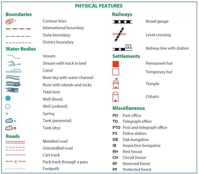
Signs and Symbols Used on a Map
- Maps use signs and symbols to represent physical and cultural features due to limited space.
- Features include relief, drainage, vegetation, settlements, temples, villages, cities, roads, and wells.
- Conventional signs are standardized globally for clarity and legibility.
- Symbols are small, recognizable, and convey specific information.
- Symbols are divided into three types: point, line, and area symbols.
- Point symbols represent specific locations like buildings, cities, dipping tanks, or trigonometrical beacons using simple shapes.
- Line symbols show linear features like roads, rivers, power lines, and borders, with variations like colored, thick, bold, multiple, or dotted lines.
Point Symbols
- Point symbols show a specific place, location, or site.
- They use basic shapes for easy recognition, even when small.
- Examples include buildings, cities, dipping tanks, and trigonometrical beacons.
Line Symbols
- Line symbols represent linear features like roads, rivers, power lines, and borders.
- They vary by being colored, thick, bold, multiple, or dotted.
Physical Features
Area Symbols
- Moraine shown with a pattern of small shapes.
- Coral reef marked with a dotted pattern.
- Lake represented with a blue filled shape.
- Swamp shown with a pattern of small lines.
- Tidal flat marked with a specific pattern.
- Mangroves represented with a tree-like pattern.
- Relief: Contours, spot heights, trigonometrical beacons.
- Water: Lakes, rivers, waterholes, reservoirs.
- Vegetation: Cultivation, orchards, vineyards, forests, plantations, woodland.
- Political: Boundaries.
Scale of a Map
- Map scale shows the ratio of distance on the map to the actual distance on the ground.
- Scales are presented in miles and kilometers.
Types of Map Scales
Three are three types of map scales as described here:
they are:
- Direct statement
- linear scale
- Representative fraction (ratio).
Direct Statement Scale
- Expressed in words, e.g., 1 cm represents 15 km.
- Means 1 cm on the map corresponds to 15 km in reality.
- Easiest and most common method to understand.
- Should not use "equals" (e.g., 1 cm = 15 km is incorrect; use "represents").
Linear Scale or Bar Scale
- Shown as a line with numbers indicating distances.
- Requires measuring the line to determine the represented distance.
Representative Fraction or Ratio Scale
- Expressed as a ratio, e.g., 1:1,500,000.
- Means 1 unit on the map represents 1,500,000 units in reality (e.g., 1 cm = 1,500,000 cm).
- Both sides of the ratio use the same unit of measurement.
Different Scale Maps
- Large-scale maps show small areas with great detail, e.g., topographic maps or city road maps.
- Small-scale maps show large areas with less detail, e.g., maps of continents or the world.
Measuring Distance
Distance is measured to calculate real-world distances from map measurements.Three methods:
- Direct distances
- Indirect distances
- Calculating actual distance using a scale.
Measuring Direct Distances
- Measure straight-line distance between two points using a ruler.
- Use the map scale to calculate actual distance.
- Example: If 10 cm on a map with a scale of 1 cm = 100 km, actual distance is 1,000 km.
- For a ratio scale of 1:10,000, 5 cm on the map equals 50,000 cm (0.5 km) in reality.
Measuring Indirect Distances
- Measure distance along a route (e.g., a road) using a string to follow the path’s shape.
- Mark the distance on the string and measure it against the map’s scale.
- Example: If string measures 15 cm and scale is 1 cm = 5 km, actual distance is 75 km.
Calculating Actual Distance Using a Scale
- Example: For a scale of 1:5,000, if map distance is 8 cm, actual distance is calculated.
- Calculation: 8 cm × 5,000 = 40,000 cm = 400 m.
Solution
- Scale is 1:5000, meaning 1 cm on the map represents 5000 cm in reality.
- Map distance to actual distance ratio is 1:5000.
- Given map distance is 8 cm.
- Let the actual distance be 'a' cm.
- Set up the ratio: 8:a = 1:5000.
- Invert the fraction: a/8 = 5000/1.
- Multiply both sides by 8: a = 8 × 5000.
- Calculate: a = 40000 cm.
- Convert to meters: 40000 cm ÷ 100 = 400 m.
- Actual distance is 400 m.
Points To Remember
- Maps are two-dimensional representations of the Earth’s surface.
- Scales are shown as statements, ratios, or linear scales.
- Maps are categorized as large-scale or small-scale based on their scale.
- Conventional signs and symbols convey information in limited map space.
The document Representation of Geographical Features Chapter Notes | Geography Class 7 ICSE is a part of the Class 7 Course Geography Class 7 ICSE.
All you need of Class 7 at this link: Class 7
|
11 videos|50 docs|10 tests
|
FAQs on Representation of Geographical Features Chapter Notes - Geography Class 7 ICSE
| 1. What are topographical maps and how do they differ from regular maps? |  |
Ans.Topographical maps are detailed representations of the Earth's surface that show elevation, terrain, and landforms using contour lines. Unlike regular maps, which may focus on roadways and political boundaries, topographical maps provide a three-dimensional view of the landscape, allowing users to understand the steepness of slopes and the layout of natural features.
| 2. How are colors used on maps to indicate different geographical features? | |
Ans.Colors on maps are used to differentiate between various geographical features. For example, blue typically represents water bodies like rivers and lakes, green indicates vegetation such as forests and parks, brown shows elevation and contour lines, and yellow indicates areas of agriculture or desert. These color conventions help users quickly identify and understand the features of the terrain.
| 3. What are some common signs and symbols found on maps, and what do they represent? | |
Ans.Common signs and symbols on maps include icons for mountains, rivers, roads, and buildings. For instance, a triangle may represent a mountain peak, a wavy line can indicate a river, and a solid line may depict a road. Additionally, symbols for parks, schools, and airports are often standardized, making it easier for users to interpret the map's information effectively.
| 4. How is the scale of a map defined, and why is it important? | |
Ans.The scale of a map is the ratio of a distance on the map to the corresponding distance on the ground. It is important because it allows users to measure real-world distances accurately. Scales can be represented in different forms, such as a graphical scale or a numerical ratio (e.g., 1:50,000), and understanding the scale helps in planning travel routes and estimating distances.
| 5. What methods can be used to measure distances on a map? | |
Ans.Distances on a map can be measured using a ruler or a string. For a ruler, the user aligns it with the path they wish to measure and then uses the scale to convert the measurement. Using string can be helpful for winding paths; the string is laid along the route, then measured against the scale. Additionally, some maps come with a graphical scale that can be used directly to measure distances.
About this Document

4.62/5
Rating

Oct 12, 2025
Last updated
Related Exams
Document Description: Chapter Notes: Representation of Geographical Features for Class 7 2025 is part of Geography Class 7 ICSE preparation.
The notes and questions for Chapter Notes: Representation of Geographical Features have been prepared according to the Class 7 exam syllabus. Information about Chapter Notes: Representation of Geographical Features covers topics
like Introduction, Topographical Maps, Use of Colours on Maps, Signs and Symbols Used on a Map, Scale of a Map, Measuring Distance and Chapter Notes: Representation of Geographical Features Example, for Class 7 2025 Exam. Find important definitions, questions, notes, meanings, examples, exercises and tests below for Chapter Notes: Representation of Geographical Features.
Introduction of Chapter Notes: Representation of Geographical Features in English is available as part of our Geography Class 7 ICSE
for Class 7 & Chapter Notes: Representation of Geographical Features in Hindi for Geography Class 7 ICSE course.
Download more important topics related with notes, lectures and mock test series for Class 7
Exam by signing up for free. Class 7: Representation of Geographical Features Chapter Notes | Geography Class 7 ICSE
Description
Full syllabus notes, lecture & questions for Representation of Geographical Features Chapter Notes | Geography Class 7 ICSE - Class 7 | Plus excerises question with solution to help you revise complete syllabus for Geography Class 7 ICSE | Best notes, free PDF download
Information about Chapter Notes: Representation of Geographical Features
In this doc you can find the meaning of Chapter Notes: Representation of Geographical Features defined & explained in the simplest way possible. Besides explaining types of
Chapter Notes: Representation of Geographical Features theory, EduRev gives you an ample number of questions to practice Chapter Notes: Representation of Geographical Features tests, examples and also practice Class 7
tests

Related Searches
Representation of Geographical Features Chapter Notes | Geography Class 7 ICSE
,ppt
,Sample Paper
,Representation of Geographical Features Chapter Notes | Geography Class 7 ICSE
,Free
,mock tests for examination
,Previous Year Questions with Solutions
,Objective type Questions
,study material
,practice quizzes
,Summary
,Representation of Geographical Features Chapter Notes | Geography Class 7 ICSE
,Viva Questions
,MCQs
,Semester Notes
,past year papers
,Exam
,Important questions
,video lectures
,shortcuts and tricks
,Extra Questions
;


Additional Information about Chapter Notes: Representation of Geographical Features for Class 7 Preparation
Chapter Notes: Representation of Geographical Features Free PDF Download
The Chapter Notes: Representation of Geographical Features is an invaluable resource that delves deep into the core of the Class 7 exam.
These study notes are curated by experts and cover all the essential topics and concepts, making your preparation more efficient and effective.
With the help of these notes, you can grasp complex subjects quickly, revise important points easily,
and reinforce your understanding of key concepts. The study notes are presented in a concise and easy-to-understand manner,
allowing you to optimize your learning process. Whether you're looking for best-recommended books, sample papers, study material,
or toppers' notes, this PDF has got you covered. Download the Chapter Notes: Representation of Geographical Features now and kickstart your journey towards success in the Class 7 exam.
Importance of Chapter Notes: Representation of Geographical Features
The importance of Chapter Notes: Representation of Geographical Features cannot be overstated, especially for Class 7 aspirants.
This document holds the key to success in the Class 7 exam.
It offers a detailed understanding of the concept, providing invaluable insights into the topic.
By knowing the concepts well in advance, students can plan their preparation effectively.
Utilize this indispensable guide for a well-rounded preparation and achieve your desired results.
Chapter Notes: Representation of Geographical Features
Chapter Notes: Representation of Geographical Features Notes offer in-depth insights into the specific topic to help you master it with ease.
This comprehensive document covers all aspects related to Chapter Notes: Representation of Geographical Features.
It includes detailed information about the exam syllabus, recommended books, and study materials for a well-rounded preparation.
Practice papers and question papers enable you to assess your progress effectively.
Additionally, the paper analysis provides valuable tips for tackling the exam strategically.
Access to Toppers' notes gives you an edge in understanding complex concepts.
Whether you're a beginner or aiming for advanced proficiency, Chapter Notes: Representation of Geographical Features Notes on EduRev are your ultimate resource for success.
Chapter Notes: Representation of Geographical Features Class 7 Questions
The "Chapter Notes: Representation of Geographical Features Class 7 Questions" guide is a valuable resource for all aspiring students preparing for the
Class 7 exam. It focuses on providing a wide range of practice questions to help students gauge
their understanding of the exam topics. These questions cover the entire syllabus, ensuring comprehensive preparation.
The guide includes previous years' question papers for students to familiarize themselves with the exam's format and difficulty level.
Additionally, it offers subject-specific question banks, allowing students to focus on weak areas and improve their performance.
Study Chapter Notes: Representation of Geographical Features on the App
Students of Class 7 can study Chapter Notes: Representation of Geographical Features alongwith tests & analysis from the EduRev app,
which will help them while preparing for their exam. Apart from the Chapter Notes: Representation of Geographical Features,
students can also utilize the EduRev App for other study materials such as previous year question papers, syllabus, important questions, etc.
The EduRev App will make your learning easier as you can access it from anywhere you want.
The content of Chapter Notes: Representation of Geographical Features is prepared as per the latest Class 7 syllabus.
|
© EduRev
|
Education Revolution
|


|


Signup to see your scores
go up within 7 days!
Access 1000+ FREE Docs, Videos and Tests
Takes less than 10 seconds to signup