Class 8 Exam > Class 8 Notes > Geography Class 8 ICSE > Case Study - I
Case Study - I | Geography Class 8 ICSE PDF Download
| Table of contents |
|
| Nepal |
|
| Earthquake in Nepal |
|
| Reasons Behind the Earthquake |
|
| Impact of Nepal Earthquake |
|
| Impact of Earthquake on Mt Everest |
|
| Environmental Impact of Earthquake |
|

Nepal
- Nepal has three distinct geographical regions.
- Terai: A fertile, flat land bordering India with a tropical climate, ideal for farming.
- Terai grows crops like rice, wheat, pulses, sugarcane, jute, tobacco, and maize.
- Pahads: Hilly areas without snow, home to urban centers like Kathmandu and Pokhara.
- About 45% of Nepal's population lives in the Pahads region.
- Mountains: High, snow-covered peaks, challenging for living due to altitude and harsh conditions.
- Nepal hosts many of the world’s tallest mountains, making habitation difficult.
Earthquake in Nepal
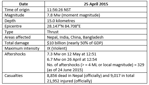
- On April 25, 2015, a 7.8 magnitude earthquake hit Nepal, the worst in 81 years.
- A state of emergency was declared across the nation after the quake.
- Nearly 10,000 deaths were reported within a week.
- The earthquake affected central and eastern Nepal, northern India, northwestern Bangladesh, southern Tibet, and western Bhutan.
- Tremors were felt in the Ganga River plains of northern India.
Earthquake Profile of Nepal - 2015
Reasons Behind the Earthquake
- Nepal lies between the Indian and Eurasian tectonic plates, making it prone to quakes.
- These plates have collided for 50 million years, pushing India northward.
- This collision formed the Himalayan mountains.
- Earthquakes occur during mountain formation due to plate movement.
- The Indian Plate moves constantly, pushing the fixed Eurasian Plate upward.
- Energy builds up underground, causing rocks to break from friction.
- This energy release triggered the 2015 earthquake in Nepal.
Impact of Nepal Earthquake
- The 2015 quake was Nepal’s worst natural disaster.
- Many villages, towns, and buildings were fully destroyed.
- Numerous lives were lost due to the disaster.
- Kathmandu, Nepal’s capital, saw widespread destruction.
- Many concrete buildings collapsed in urban areas.
- People fled to streets and open spaces as dust clouds rose.
- Wide cracks appeared on roads and building walls.
Patan Durbar Square
- A UNESCO World Heritage Site known for Newar architecture.
- Features a red-brick tiled square and an ancient royal palace.
- The palace was home to the Malla Kings of Lalitpur.
- Parts of Patan Durbar Square were damaged and later rebuilt.
Swayambhunath
- A 2,500-year-old Buddhist stupa located on Kathmandu’s western hills.
- A sacred site filled with symbols and historic artifacts.
- Many of its structures and artifacts were destroyed in the quake.
Impact of Earthquake on Mt Everest
- The 7.8 magnitude quake shifted Mount Everest by 3 centimeters.
- Mount Everest, over 8,848 meters (29,000 feet) tall, lies between China and Nepal.
- Normally, Everest moves 4 centimeters northeast each year.
- The 2015 quake reversed this northeast movement.
- The mountain and nearby areas shifted vertically and horizontally.
- At least 18 people died on Everest, making April 25, 2015, the deadliest day there.
- An avalanche in Langtang Valley left 250 people missing.
Environmental Impact of Earthquake
- Forests in 31 districts, including Langtang Valley and Manaslu Conservation Area, were damaged.
- High demand for timber led to deforestation for rebuilding homes.
- Local vegetation, key for soil conservation, was destroyed.
- Regrowing vegetation and forests takes many years.
- Gosaikunda and Gokyo lakes, home to red panda, musk deer, and Himalayan tahr, were affected.
- Habitats like blue pine, temperate oak, sub-alpine, and birch forests in Langtang National Park were harmed.
- Water shortages worsened due to low rainfall in affected areas.
- Solid waste management became a challenge.
- Debris from collapsed buildings created environmental issues.
The document Case Study - I | Geography Class 8 ICSE is a part of the Class 8 Course Geography Class 8 ICSE.
All you need of Class 8 at this link: Class 8
|
11 videos|41 docs|10 tests
|
FAQs on Case Study - I - Geography Class 8 ICSE
| 1. What were the main reasons behind the earthquake in Nepal? |  |
Ans. The main reasons behind the earthquake in Nepal, particularly the one that struck on April 25, 2015, include the tectonic activity due to the collision of the Indian and Eurasian plates. This geological process leads to significant stress and pressure buildup along fault lines, resulting in seismic activity. The region is known for its complex geological structure, which makes it prone to earthquakes.
| 2. What was the impact of the Nepal earthquake on the local population? | |
Ans. The impact of the Nepal earthquake on the local population was devastating. It resulted in the loss of nearly 9,000 lives and injured over 22,000 people. Many homes, schools, and hospitals were destroyed, leading to displacement of thousands of families. The economy was severely affected, with significant damage to infrastructure and livelihoods, particularly in rural areas.
| 3. How did the earthquake affect Mount Everest and its surroundings? | |
Ans. The earthquake had a significant impact on Mount Everest, causing avalanches that resulted in fatalities and injuries among climbers and Sherpas. It also led to the shifting of glaciers and changes in the landscape, making climbing conditions more dangerous. The base camp experienced major destruction, affecting the climbing season for many expeditions.
| 4. What were the environmental impacts of the earthquake in Nepal? | |
Ans. The environmental impacts of the earthquake in Nepal included landslides, which altered the landscape and ecosystems. Deforestation and soil erosion increased due to the destruction of vegetation and infrastructure. Additionally, the earthquake affected water sources and led to concerns about the long-term sustainability of the environment in affected regions.
| 5. What measures were taken for disaster management and recovery after the earthquake in Nepal? | |
Ans. After the earthquake, the Nepalese government, along with various international organizations, initiated disaster management and recovery measures. These included emergency rescue operations, provision of temporary shelters, and medical assistance to the injured. Long-term recovery efforts focused on rebuilding infrastructure, restoring livelihoods, and implementing better preparedness and response strategies to mitigate the impacts of future earthquakes.
About this Document

Oct 09, 2025
Last updated
Related Exams
Document Description: Case Study - I for Class 8 2025 is part of Geography Class 8 ICSE preparation.
The notes and questions for Case Study - I have been prepared according to the Class 8 exam syllabus. Information about Case Study - I covers topics
like Nepal, Earthquake in Nepal, Reasons Behind the Earthquake, Impact of Nepal Earthquake, Impact of Earthquake on Mt Everest, Environmental Impact of Earthquake and Case Study - I Example, for Class 8 2025 Exam. Find important definitions, questions, notes, meanings, examples, exercises and tests below for Case Study - I.
Introduction of Case Study - I in English is available as part of our Geography Class 8 ICSE
for Class 8 & Case Study - I in Hindi for Geography Class 8 ICSE course.
Download more important topics related with notes, lectures and mock test series for Class 8
Exam by signing up for free. Class 8: Case Study - I | Geography Class 8 ICSE
Description
Full syllabus notes, lecture & questions for Case Study - I | Geography Class 8 ICSE - Class 8 | Plus excerises question with solution to help you revise complete syllabus for Geography Class 8 ICSE | Best notes, free PDF download
Information about Case Study - I
In this doc you can find the meaning of Case Study - I defined & explained in the simplest way possible. Besides explaining types of
Case Study - I theory, EduRev gives you an ample number of questions to practice Case Study - I tests, examples and also practice Class 8
tests

Related Searches
Objective type Questions
,shortcuts and tricks
,practice quizzes
,Semester Notes
,video lectures
,Previous Year Questions with Solutions
,Extra Questions
,study material
,past year papers
,ppt
,Sample Paper
,Summary
,Case Study - I | Geography Class 8 ICSE
,MCQs
,mock tests for examination
,Free
,Case Study - I | Geography Class 8 ICSE
,Case Study - I | Geography Class 8 ICSE
,Exam
,Viva Questions
,Important questions
;


Additional Information about Case Study - I for Class 8 Preparation
Case Study - I Free PDF Download
The Case Study - I is an invaluable resource that delves deep into the core of the Class 8 exam.
These study notes are curated by experts and cover all the essential topics and concepts, making your preparation more efficient and effective.
With the help of these notes, you can grasp complex subjects quickly, revise important points easily,
and reinforce your understanding of key concepts. The study notes are presented in a concise and easy-to-understand manner,
allowing you to optimize your learning process. Whether you're looking for best-recommended books, sample papers, study material,
or toppers' notes, this PDF has got you covered. Download the Case Study - I now and kickstart your journey towards success in the Class 8 exam.
Importance of Case Study - I
The importance of Case Study - I cannot be overstated, especially for Class 8 aspirants.
This document holds the key to success in the Class 8 exam.
It offers a detailed understanding of the concept, providing invaluable insights into the topic.
By knowing the concepts well in advance, students can plan their preparation effectively.
Utilize this indispensable guide for a well-rounded preparation and achieve your desired results.
Case Study - I Notes
Case Study - I Notes offer in-depth insights into the specific topic to help you master it with ease.
This comprehensive document covers all aspects related to Case Study - I.
It includes detailed information about the exam syllabus, recommended books, and study materials for a well-rounded preparation.
Practice papers and question papers enable you to assess your progress effectively.
Additionally, the paper analysis provides valuable tips for tackling the exam strategically.
Access to Toppers' notes gives you an edge in understanding complex concepts.
Whether you're a beginner or aiming for advanced proficiency, Case Study - I Notes on EduRev are your ultimate resource for success.
Case Study - I Class 8 Questions
The "Case Study - I Class 8 Questions" guide is a valuable resource for all aspiring students preparing for the
Class 8 exam. It focuses on providing a wide range of practice questions to help students gauge
their understanding of the exam topics. These questions cover the entire syllabus, ensuring comprehensive preparation.
The guide includes previous years' question papers for students to familiarize themselves with the exam's format and difficulty level.
Additionally, it offers subject-specific question banks, allowing students to focus on weak areas and improve their performance.
Study Case Study - I on the App
Students of Class 8 can study Case Study - I alongwith tests & analysis from the EduRev app,
which will help them while preparing for their exam. Apart from the Case Study - I,
students can also utilize the EduRev App for other study materials such as previous year question papers, syllabus, important questions, etc.
The EduRev App will make your learning easier as you can access it from anywhere you want.
The content of Case Study - I is prepared as per the latest Class 8 syllabus.
|
© EduRev
|
Education Revolution
|


|


Signup to see your scores
go up within 7 days!
Access 1000+ FREE Docs, Videos and Tests
Takes less than 10 seconds to signup