SSS 1 Exam > SSS 1 Notes > Geography for SSS 1 > Chapter Notes: Geographic Grid Latitudes and Longitudes
Geographic Grid Latitudes and Longitudes Chapter Notes | Geography for SSS 1 PDF Download
| Table of contents |
|
| Introduction |
|
| Latitude and Longitude |
|
| Concepts of Longitudes - Prime Meridian, GMT & IDL |
|
| Key Words |
|

Introduction
The Geographic Grid is a system of lines on a globe or map that helps us locate places accurately. It consists of latitudes and longitudes, which are imaginary lines drawn to measure distances on Earth's surface. Latitudes run parallel to the Equator, dividing the Earth into northern and southern hemispheres, while longitudes run from pole to pole, helping to determine time and location. This chapter explores the concepts of latitude and longitude, their uses in navigation and timekeeping, and the significance of key lines like the Equator, Prime Meridian, and International Date Line. Understanding these concepts is essential for studying Earth's geography and its thermal zones.Latitude and Longitude
- The Geographic Grid is a network of latitude and longitude lines drawn on a globe or map to locate places.
- The Equator and Prime Meridian are the main reference lines for this grid.
- The Equator is an imaginary horizontal line at 0° that splits the Earth into the Northern and Southern Hemispheres.
- Latitude measures how far a point is north or south of the Equator, in degrees, from the Earth's center.
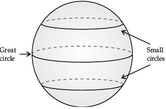
- Lines of latitude connect places with the same latitude and are called parallels because they run parallel to the Equator, from west to east.
- The Equator, at 0°, is the longest latitude line; other parallels get shorter as they move toward the poles, which are just points at 90° N and 90° S.
- Only the Equator is a great circle among latitude lines; others are smaller circles.
- There are 181 latitude lines (90 north + 1 Equator + 90 south), spaced 1° apart.
- The distance between two consecutive latitude lines is about 111 km (69 miles).
- Latitude lines help in:
- Calculating ground distances between places north or south of the Equator.
- Identifying the Earth's thermal zones.
- Locating places when combined with longitude lines.
- Key latitude lines include:
- Equator (0°)
- Tropic of Cancer (23½° N)
- Tropic of Capricorn (23½° S)
- Arctic Circle (66½° N)
- Antarctic Circle (66½° S)
- North Pole (90° N)
- South Pole (90° S)
- Thermal zones based on latitude:
- Torrid Zone: Between Tropic of Cancer (23½° N) and Tropic of Capricorn (23½° S); the hottest zone.
- Temperate Zone: North Temperate Zone (23½° N to 66½° N) and South Temperate Zone (23½° S to 66½° S); moderate temperatures.
- Frigid Zone: North Frigid Zone (66½° N to 90° N) and South Frigid Zone (66½° S to 90° S); very cold temperatures.
- Longitude measures how far a point is east or west of the Prime Meridian, in degrees, from the Earth's center.
- Lines of longitude, or meridians, connect places with the same longitude, running from pole to pole.
- Meridians are called so because places along the same meridian experience noon at the same time.
- All meridians are equal in length, forming semicircles that meet at the poles.
- Opposite meridians (e.g., 180° E and 180° W, or 0° and 180°) form great circles.
- There are 360 meridians (180 east + 180 west), spaced 1° apart.
- The distance between two consecutive meridians is 111 km at the Equator but decreases toward the poles, where it becomes 0.
- Longitude helps in:
- Locating places on a globe or map by plotting meridians from pole to pole.
- Determining time differences between places.
- Longitude and time relationship:
- The Earth rotates 360° in 24 hours, covering 15° per hour or 1° every 4 minutes.
- When it’s noon at the Prime Meridian (0°), places east of it are ahead in time, and places west are behind.
- For every 1° east, add 4 minutes; for every 1° west, subtract 4 minutes to find local time.
- Great circles:
- A great circle is any circle that passes through the Earth’s center, dividing it into two equal halves.
- All meridians paired with their opposite meridians (e.g., 0° and 180°) form great circles.
- The Equator is the only latitude line that is a great circle.
- Great circles are used to find the shortest routes for ships and aircraft, saving time.
Concepts of Longitudes - Prime Meridian, GMT & IDL
- Longitudes are used to calculate the time at different places.
- The Earth’s rotation causes variations in sunrise and sunset times across places.
- The Earth rotates 360° in 24 hours, covering 15° of longitude per hour or 1° every 4 minutes.
- If it’s 12 noon at the Prime Meridian (0°), it’s 1 p.m. at 15° E and 11 a.m. at 15° W, as the Earth rotates west to east.
- Local time is based on the Sun’s position overhead at noon at a specific place.
- Local time changes by 4 minutes for every 1° of longitude.
- Standard time is the uniform time used across a country, based on the local time of its central meridian (Standard Meridian).
- Greenwich Mean Time (GMT) is the standard time at 0° longitude, used in Great Britain.
- A time zone is a region using the same standard time, typically covering 15° of longitude.
- The world is divided into 24 time zones, each spanning 15° of longitude.
- The International Date Line(IDL) is an imaginary line near 180° E/W in the Pacific Ocean, adjusted to avoid landmasses for consistent time and date.
- Crossing the IDL from east to west adds a day; crossing from west to east subtracts a day.
- The Prime Meridian (0°) and IDL (180°) divide the Earth into Eastern and Western Hemispheres.
- Some geographers use 20° W and 160° E as the boundaries for the Eastern and Western Hemispheres.
- Great circles:
- A great circle is a circle that passes through the Earth’s center, splitting it into two equal parts.
- The Equator and all pairs of opposite meridians (e.g., 0° and 180°) are great circles.
- Great circles are the largest circles on a sphere, used for navigation to find the shortest routes.
- The Equator is the only east-west great circle.
- Great circle distance formula: d = r cos-1[cos σ1 cos σ2 cos(Λ1 - Λ2) + sin σ1 sin σ2]
Key Words
- Geographic Grid: A system of latitude and longitude lines on a globe to locate places.
- Latitude: The angle measuring a point’s distance north or south of the Equator, in degrees.
- Longitude: The angle measuring a point’s distance east or west of the Prime Meridian, in degrees.
- Meridians: Vertical lines connecting places with the same longitude, running from pole to pole.
- Prime Meridian: The 0° longitude line, passing through Greenwich, used as a reference for east-west measurements.
- Local Time: Time based on the Sun’s position overhead at noon at a specific place.
- Standard Time: Uniform time across a country, based on its central meridian’s local time.
- Time Zone: A region using the same standard time, covering about 15° of longitude.
- IDL: The International Date Line, near 180° longitude, where crossing changes the date.
The document Geographic Grid Latitudes and Longitudes Chapter Notes | Geography for SSS 1 is a part of the SSS 1 Course Geography for SSS 1.
All you need of SSS 1 at this link: SSS 1
|
47 docs|6 tests
|
FAQs on Geographic Grid Latitudes and Longitudes Chapter Notes - Geography for SSS 1
| 1. What are latitude and longitude, and why are they important in geography? |  |
Ans.Latitude and longitude are the two coordinates used to determine the precise location of any point on the Earth's surface. Latitude measures how far north or south a point is from the Equator, while longitude measures how far east or west a point is from the Prime Meridian. They are crucial for navigation, mapping, and understanding geographic relationships.
| 2. What is the Prime Meridian and its significance in geography? | |
Ans.The Prime Meridian is the zero-degree line of longitude that divides the Earth into the Eastern and Western Hemispheres. Established in 1884 during the International Meridian Conference, it serves as the reference point for Greenwich Mean Time (GMT) and is essential for global navigation and timekeeping.
| 3. How does the concept of Greenwich Mean Time (GMT) relate to longitude? | |
Ans.Greenwich Mean Time (GMT) is based on the mean solar time at the Prime Meridian in Greenwich, England. Each degree of longitude corresponds to a time difference of four minutes; thus, locations to the east of the Prime Meridian are ahead of GMT, while those to the west are behind. This system helps standardize time across different regions.
| 4. What is the International Date Line (IDL), and how does it function? | |
Ans.The International Date Line (IDL) is an imaginary line located approximately along the 180-degree longitude line in the Pacific Ocean, where the date changes by one day when crossed. When traveling west across the IDL, one adds a day, and when traveling east, one subtracts a day. This line is crucial for maintaining a consistent global calendar.
| 5. How do latitude and longitude affect climate and weather patterns? | |
Ans.Latitude significantly influences climate as it determines the angle of sunlight received by a region, affecting temperatures and seasonal variations. Areas near the equator, with low latitudes, tend to be warmer, while higher latitudes experience cooler climates. Longitude can influence local weather patterns due to geographical features and ocean currents.
About this Document

4.79/5
Rating

Oct 22, 2025
Last updated
Related Exams
Document Description: Chapter Notes: Geographic Grid Latitudes and Longitudes for SSS 1 2025 is part of Geography for SSS 1 preparation.
The notes and questions for Chapter Notes: Geographic Grid Latitudes and Longitudes have been prepared according to the SSS 1 exam syllabus. Information about Chapter Notes: Geographic Grid Latitudes and Longitudes covers topics
like Introduction, Latitude and Longitude, Concepts of Longitudes - Prime Meridian, GMT & IDL, Key Words and Chapter Notes: Geographic Grid Latitudes and Longitudes Example, for SSS 1 2025 Exam. Find important definitions, questions, notes, meanings, examples, exercises and tests below for Chapter Notes: Geographic Grid Latitudes and Longitudes.
Introduction of Chapter Notes: Geographic Grid Latitudes and Longitudes in English is available as part of our Geography for SSS 1
for SSS 1 & Chapter Notes: Geographic Grid Latitudes and Longitudes in Hindi for Geography for SSS 1 course.
Download more important topics related with notes, lectures and mock test series for SSS 1
Exam by signing up for free. SSS 1: Geographic Grid Latitudes and Longitudes Chapter Notes | Geography for SSS 1
Description
Full syllabus notes, lecture & questions for Geographic Grid Latitudes and Longitudes Chapter Notes | Geography for SSS 1 - SSS 1 | Plus excerises question with solution to help you revise complete syllabus for Geography for SSS 1 | Best notes, free PDF download
Information about Chapter Notes: Geographic Grid Latitudes and Longitudes
In this doc you can find the meaning of Chapter Notes: Geographic Grid Latitudes and Longitudes defined & explained in the simplest way possible. Besides explaining types of
Chapter Notes: Geographic Grid Latitudes and Longitudes theory, EduRev gives you an ample number of questions to practice Chapter Notes: Geographic Grid Latitudes and Longitudes tests, examples and also practice SSS 1
tests

Related Searches
Geographic Grid Latitudes and Longitudes Chapter Notes | Geography for SSS 1
,shortcuts and tricks
,Geographic Grid Latitudes and Longitudes Chapter Notes | Geography for SSS 1
,Previous Year Questions with Solutions
,Objective type Questions
,Sample Paper
,practice quizzes
,Exam
,video lectures
,Summary
,Free
,MCQs
,ppt
,Semester Notes
,past year papers
,Important questions
,Extra Questions
,Viva Questions
,study material
,mock tests for examination
,Geographic Grid Latitudes and Longitudes Chapter Notes | Geography for SSS 1
;


Additional Information about Chapter Notes: Geographic Grid Latitudes and Longitudes for SSS 1 Preparation
Chapter Notes: Geographic Grid Latitudes and Longitudes Free PDF Download
The Chapter Notes: Geographic Grid Latitudes and Longitudes is an invaluable resource that delves deep into the core of the SSS 1 exam.
These study notes are curated by experts and cover all the essential topics and concepts, making your preparation more efficient and effective.
With the help of these notes, you can grasp complex subjects quickly, revise important points easily,
and reinforce your understanding of key concepts. The study notes are presented in a concise and easy-to-understand manner,
allowing you to optimize your learning process. Whether you're looking for best-recommended books, sample papers, study material,
or toppers' notes, this PDF has got you covered. Download the Chapter Notes: Geographic Grid Latitudes and Longitudes now and kickstart your journey towards success in the SSS 1 exam.
Importance of Chapter Notes: Geographic Grid Latitudes and Longitudes
The importance of Chapter Notes: Geographic Grid Latitudes and Longitudes cannot be overstated, especially for SSS 1 aspirants.
This document holds the key to success in the SSS 1 exam.
It offers a detailed understanding of the concept, providing invaluable insights into the topic.
By knowing the concepts well in advance, students can plan their preparation effectively.
Utilize this indispensable guide for a well-rounded preparation and achieve your desired results.
Chapter Notes: Geographic Grid Latitudes and Longitudes
Chapter Notes: Geographic Grid Latitudes and Longitudes Notes offer in-depth insights into the specific topic to help you master it with ease.
This comprehensive document covers all aspects related to Chapter Notes: Geographic Grid Latitudes and Longitudes.
It includes detailed information about the exam syllabus, recommended books, and study materials for a well-rounded preparation.
Practice papers and question papers enable you to assess your progress effectively.
Additionally, the paper analysis provides valuable tips for tackling the exam strategically.
Access to Toppers' notes gives you an edge in understanding complex concepts.
Whether you're a beginner or aiming for advanced proficiency, Chapter Notes: Geographic Grid Latitudes and Longitudes Notes on EduRev are your ultimate resource for success.
Chapter Notes: Geographic Grid Latitudes and Longitudes SSS 1 Questions
The "Chapter Notes: Geographic Grid Latitudes and Longitudes SSS 1 Questions" guide is a valuable resource for all aspiring students preparing for the
SSS 1 exam. It focuses on providing a wide range of practice questions to help students gauge
their understanding of the exam topics. These questions cover the entire syllabus, ensuring comprehensive preparation.
The guide includes previous years' question papers for students to familiarize themselves with the exam's format and difficulty level.
Additionally, it offers subject-specific question banks, allowing students to focus on weak areas and improve their performance.
Study Chapter Notes: Geographic Grid Latitudes and Longitudes on the App
Students of SSS 1 can study Chapter Notes: Geographic Grid Latitudes and Longitudes alongwith tests & analysis from the EduRev app,
which will help them while preparing for their exam. Apart from the Chapter Notes: Geographic Grid Latitudes and Longitudes,
students can also utilize the EduRev App for other study materials such as previous year question papers, syllabus, important questions, etc.
The EduRev App will make your learning easier as you can access it from anywhere you want.
The content of Chapter Notes: Geographic Grid Latitudes and Longitudes is prepared as per the latest SSS 1 syllabus.
|
© EduRev
|
Education Revolution
|


|


Signup to see your scores
go up
within 7 days!
within 7 days!
Takes less than 10 seconds to signup