Landforms of the Earth Chapter Notes | Science for Grade 7 PDF Download
| Table of contents |
|
| Introduction |
|
| Structure of the Earth |
|
| Formation of Landforms |
|
| Various Types of Landforms |
|
| Importance of Landforms |
|
| Maps |
|

Introduction
The chapter "Landforms of the Earth" explores the various natural features that shape the Earth's surface, such as mountains, plateaus, plains, valleys, and basins. It explains the structure of the Earth, including its core, mantle, and crust, and discusses how internal and external forces like plate tectonics, volcanic activities, erosion, and deposition create diverse landforms. The chapter also highlights the importance of these landforms in influencing climate, supporting biodiversity, providing resources, and fostering human civilizations.
Structure of the Earth
The Earth is made of several concentric layers. The outer layer of the Earth is known as the lithosphere. The interior of the Earth is divided into three layers—core, mantle and crust.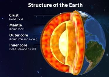
Crust (Lithosphere)
- Uppermost layer made of solid rocks.
- Thinnest layer, about 35 km thick on continents and 5 km on ocean floors.
- Continental crust contains silica and alumina, known as SIAL.
- Oceanic crust mainly consists of silica and magnesium, known as SIMA.
Mantle (Barysphere)
- Located below the crust, extends to a depth of 2,900 km.
- Divided into upper mantle and lower mantle.
- At 100–250 km depth, mantle is semi-molten, called asthenosphere.
Core
- Innermost layer with a radius of about 3,500 km.
- Made of nickel and iron, known as NIFE.
- Has very high temperature and pressure.
- Boundary between mantle and core is called Gutenberg Discontinuity.
- The discontinuity between the crust and the mantle is known as Mohorovicic Discontinuity. It forms the boundary between the crust and the mantle.
Isostasy
- State of gravitational balance between lithosphere and asthenosphere.
- Continental crust is less dense and extends deeper into asthenosphere than oceanic crust.
- Both continents and ocean basins float on semi-molten asthenosphere, maintaining balance.
Formation of Landforms
A landform is a natural feature formed on the surface of the Earth. Landforms are formed because of the following reasons:Plate Tectonics
- Lithosphere is divided into several plates floating on asthenosphere.
- Plates collide or push each other, causing landform formation.
- Orogenic movements form fold mountains.
- Sedimentary rocks between plates get compressed, leading to folding.
- Examples: Himalayas and Alps formed by plate collision.
Upliftment and Submergence
- Vertical movements (epeirogenic) cause land to rise or sink.
- Caused by faulting, forming block mountains, rift valleys, and basins.
Sudden Forces
- Volcanic activities and earthquakes are sudden forces.
- Known as constructive forces, they create relief features.
- Examples: Volcanic mountains, plateaus from volcanoes, lakes from earthquakes.
Exogenic Forces
- Occur on Earth's surface, caused by rivers, glaciers, and winds.
- Create landforms through erosion and deposition.
- Known as destructive forces due to weathering and erosion.
Various Types of Landforms
There are five major types of landforms—mountains, plateaus, plains, valleys and basins.Mountains
Three types: fold mountains, block mountains, and volcanic mountains.Fold Mountains
- Formed by large-scale horizontal movements in Earth's crust.
- Caused by tectonic plates moving toward each other, folding Earth's layers.
- Upfolds are anticlines; downfolds are synclines.
- Examples: Himalayas (Asia), Andes (South America), Alps (Europe).
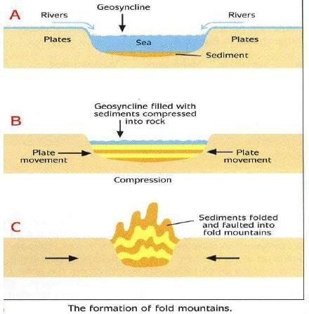
- Geosyncline: Sedimentary rock depression, like Tethys, where Himalayas formed.
Chief Characteristics of Fold Mountains
- Among the youngest mountains on Earth.
- Mostly made of sedimentary rocks from shallow ocean deposits.
- Longer in length but narrower in width.
- Associated with active volcanoes.
- Many islands, like West Indies, are tops of submerged fold mountains.
Block Mountains
- Formed due to faulting when tectonic plates move apart, causing cracks.
- Land between parallel faults rises, forming horsts.
- Examples: Black Forest, Vosges (Rhineland).
- Also formed when crust sinks between faults, creating graben.
- Example: East African Rift Valleys.
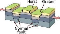 Formation of block mountains
Volcanic Mountains
- Formed by volcanic eruptions when magma erupts as lava.
- Lava accumulates and cools, building mountains.
- Examples: Mount Kilimanjaro (Africa), Mount Fuji (Japan).
Plateaus
- Elevated flat lands with a flat top called tableland.
- Four types: Intermontane, Piedmont, Volcanic, and Uplifted plateaus.
Intermontane Plateaus
- Surrounded by hills and mountains on all sides.
- Examples: Tibetan Plateau (world’s highest), Columbian Plateau.
Piedmont Plateaus
- Surrounded by mountains on one side and plains on the other.
- Also called residual plateaus.
- Examples: Patagonian Plateau, Appalachian Plateau.
Volcanic Plateaus
- Formed by lava flow from volcanic eruptions.
- Examples: Deccan Plateau, Ethiopian Plateau.
Uplifted Plateaus
- Formed when landmass center rises during volcanic activity with rounded sides.
- Examples: Chotanagpur Plateau, Ozark Plateau (USA).
Plains
- Large, flat lands with gentle undulating surfaces.
- Three types: structural, erosional, and depositional plains.
Structural Plains
- Formed by upliftment or submergence of land.
- Examples: Great Plains (USA), Coromandel Plains (India).
Erosional Plains
- Formed by erosion of hills, called peneplains.
- Also formed by wind and glacier erosion.
- Example: Niagara Plain (USA).
Depositional Plains
- Formed by deposition from rivers, winds, or marine activities.
- Examples: Great Indian Plains (Ganga), Mississippi Plains (USA).
- Wind-formed: Thar Desert, Sahara Desert.
- Marine deposition: East coast of India.
Valleys and Basins
- Valleys formed by tectonic or erosional forces.
- Example: Rift Valley (East Africa) by tectonic forces; Ganga-Brahmaputra Valley by erosion.
- Basins formed by river deposition.
Importance of Landforms
- Shape Earth's relief features and affect regional climates (e.g., Himalayas influence northern India’s climate).
- Snow-capped mountains are sources of perennial rivers.
- Mountain slopes have forests, supporting biodiversity.
- Plateaus provide various minerals.
- Volcanic plateaus have fertile black soil for farming.
- Plains with fertile soil support ancient civilizations and agriculture.
- Mountains, valleys have scenic spots attracting tourists.
Maps
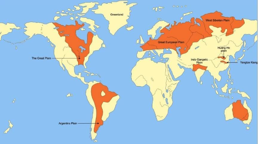 Major plains in the world
|
75 videos|160 docs|52 tests
|
FAQs on Landforms of the Earth Chapter Notes - Science for Grade 7
| 1. What are the major layers of the Earth and their characteristics? |  |
| 2. How do various landforms such as mountains and valleys form? | |
| 3. Why are landforms important to human life and the environment? | |
| 4. What are the different types of landforms found on Earth? | |
| 5. How can maps be used to understand landforms? | |


Exam
,ppt
,mock tests for examination
,study material
,Previous Year Questions with Solutions
,Viva Questions
,Sample Paper
,Objective type Questions
,Free
,Landforms of the Earth Chapter Notes | Science for Grade 7
,video lectures
,Extra Questions
,MCQs
,practice quizzes
,Summary
,shortcuts and tricks
,Important questions
,Landforms of the Earth Chapter Notes | Science for Grade 7
,past year papers
,Landforms of the Earth Chapter Notes | Science for Grade 7
,Semester Notes
;


Chapter Notes: Landforms of the Earth Free PDF Download
Importance of Chapter Notes: Landforms of the Earth
Chapter Notes: Landforms of the Earth
Chapter Notes: Landforms of the Earth Grade 7 Questions
Study Chapter Notes: Landforms of the Earth on the App
|
© EduRev
|
Education Revolution
|


|


