Insolation Chapter Notes | Geography Class 9 ICSE PDF Download

The Sun is the primary source of light and heat for our planet. Through solar radiation, it sends energy to Earth, influencing temperature, weather, and life itself. This incoming solar energy, called insolation, plays a key role in maintaining Earth’s heat balance—the delicate equilibrium between the heat we receive from the Sun and the heat Earth radiates back into space. Get ready to explore the fascinating concepts of solar radiation, heat zones, and the factors that make every place on Earth feel just right!
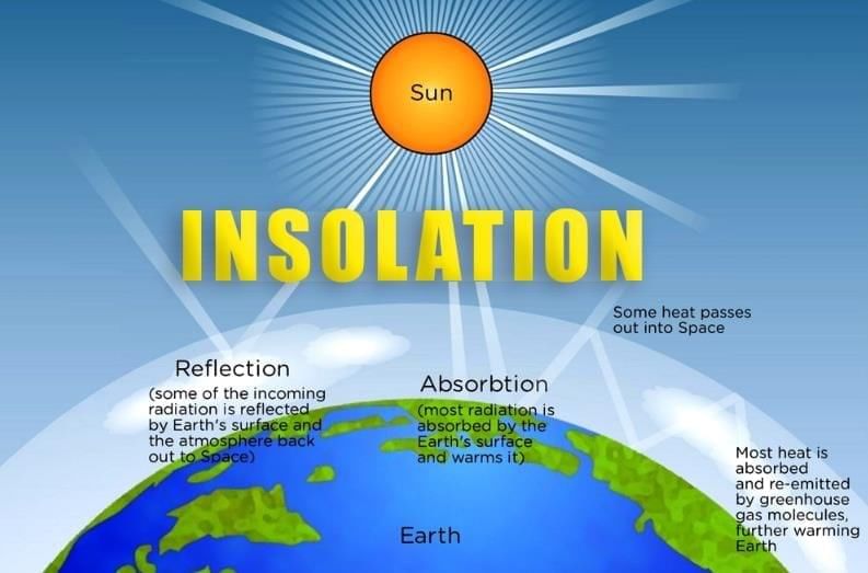
Insolation and Heat Balance
- The Sun provides light and heat to Earth through solar radiation, which is energy spread in all directions.
- Solar radiation includes visible white light, infrared radiation, ultraviolet radiation, and atomic particles called solar winds.
Example: When you feel warm standing in sunlight, you're experiencing solar radiation, mainly as infrared rays heating your skin.
Types of Radiation and Heat Balance
- Solar radiation consists of three main components: white light (visible), infrared (heat), and ultraviolet (UV) rays.
- Heat balance is the equilibrium between incoming solar radiation and outgoing terrestrial radiation on Earth.
Insolation
- Insolation refers to the solar energy received by Earth's surface, arriving as short waves.
- Only 51% of the Sun’s total energy reaches Earth’s surface.
Example: On a sunny day, the warmth you feel on the ground is due to insolation, which is more intense near the equator because of direct sunlight.
Terrestrial Radiation
- Earth does not absorb all solar heat; some is reflected back into the atmosphere as long waves.
- This heat radiated by Earth in the form of long waves is called terrestrial radiation.
Example: At night, the ground feels cooler because it loses heat through terrestrial radiation, warming the air above it.
Heat Balance
- Heat balance is the state where incoming solar radiation equals outgoing terrestrial radiation.
- This balance keeps Earth’s temperature stable over time.
Heat Budget
The heat budget is the balance between solar energy absorbed by Earth and heat lost to space.
Of 100 units of solar radiation:
- 35 units are reflected back to space by the atmosphere.
- 14 units are absorbed by the ozone layer.
- 51 units reach Earth’s surface.
- Of these 51 units, 34 units are absorbed and radiated back to the atmosphere.
- 17 units are radiated directly into space.
This process ensures a balance between incoming and outgoing energy.
Example: Think of the heat budget like a bank account—Earth "receives" 51 units of solar energy and "spends" the same amount through reflection and radiation to maintain balance.
How is the Balance Achieved?
- The uneven heating of the Earth due to its rotation on its axis is what leads to the cycles of day and night.
- Conduction is the process by which heat is transferred from the surface of the Earth to the air directly above it.
- Convection involves the movement of heat through the movement of air or water particles, as seen in the example of sea breezes.
- Land heats up and cools down quickly, which results in land breezes at night because land cools faster than the sea.
- Water, on the other hand, heats and cools slowly, creating sea breezes during the day as the sea remains cooler than the land.
Example: At the beach, in the afternoon, you experience a cool sea breeze because the warmer land heats the air above it, causing it to rise. This creates a difference in air pressure that pulls in cooler air from the sea, illustrating the process of convection.
Heat Zones
Earth is divided into three heat zones based on insolation received:
- Torrid Zone: Lies between 23½° North and South of the Equator. Receives direct vertical Sun rays, leading to maximum insolation and high temperatures.
- Temperate Zone: Lies between 23½° and 66½° North and South. Receives slanting Sun rays, resulting in moderate insolation and temperatures.
- Frigid Zone: Lies between 66½° and 90° North and South. Receives highly slanted Sun rays, causing low insolation and very cold temperatures.
Example: The Amazon rainforest in the Torrid Zone is hot and humid due to direct sunlight, while Antarctica in the Frigid Zone is freezing because of slanted rays.
Temperature
- Temperature varies across Earth because different regions receive unequal sunlight.
- Several factors affect how temperature is distributed around the planet.
Factors Affecting the Distribution of Temperature
Differential Heating and Cooling of Land and Water
- Land heats and cools faster than water, while oceans retain heat longer.
- Equatorial oceans stay warm, creating warm currents that carry heat to colder regions.
- Polar oceans are cold, and cold currents lower temperatures in equatorial areas.
Example: The North Atlantic Drift, a warm current, keeps the port of Bergen in Norway ice-free in winter, raising local temperatures.
Latitude
- Due to Earth’s spherical shape, Sun rays strike at different angles.
- Equatorial regions get vertical rays, causing high temperatures.
- Polar regions get slanting rays, leading to low temperatures and snow cover.
Example: Cities near the equator like Singapore are hot, while polar areas like Greenland remain cold due to slanted sunlight.
Altitude
- Altitude refers to the height above sea level.
- At lower altitudes, the thick air filled with dust and moisture traps heat, making it warmer.
- Higher altitudes have thinner air that retains less heat, resulting in cooler temperatures; generally, temperature decreases with increasing altitude.
Example: Hill stations like Ooty are cooler than nearby plains because the air at higher altitudes is less dense and holds less heat.
Distance from the Sea
- Places near the sea have milder temperatures due to the slow heating and cooling of water.
- Inland areas experience extreme temperatures because land heats and cools quickly.
- Example: Mumbai, a coastal city, has cooler afternoons due to sea breezes, while Delhi, inland, faces hotter afternoons.
Direction of Mountain Ranges
- Mountain ranges affect temperature by blocking or allowing winds to pass through.
- In India, the north-south Himalayas block cold polar winds, keeping the Gangetic Plains relatively warm.
- In North America, north-south mountain ranges permit cold polar winds to reach lower latitudes, leading to snowfall.
Example: New Orleans, located at 29°N latitude, experiences rare snowfall due to cold polar winds, unlike the Indian plains at similar latitudes, which do not have such cold winds.
Soil and Vegetation Cover
- Forests help lower temperatures by absorbing sunlight for photosynthesis.
- Different types of soil support various kinds of vegetation, which in turn affects the local climate and rainfall patterns.
Example:. dense forest like the Sundarbans stays cooler than a bare desert because trees use sunlight for photosynthesis, reducing the overall heat.
Cloud Cover and Humidity
- Thick clouds block incoming sunlight and trap outgoing heat, keeping temperatures moderate.
- Deserts lack clouds, so they are hot during the day and cold at night due to rapid heat loss.
Example: Tropical rainforests maintain stable temperatures around 30°C due to heavy cloud cover, in contrast to deserts, which experience extreme variations in temperature.
Measurement of Temperature
- Temperature is measured using thermometers in Centigrade or Fahrenheit scales.
- The centigrade scale has 100 divisions, Fahrenheit scale has 180 divisions.
- Conversion formula: °F = (°C × 9/5) + 32.
Example: To convert 25°C to Fahrenheit: °F = (25 × 9/5) + 32 = 45 + 32 = 77°F.
Range of Temperature
- Diurnal Range: This refers to the difference between the highest and lowest temperatures recorded in a single day. It is calculated by subtracting the minimum temperature from the maximum temperature.
- Mean Monthly Temperature: This is determined by averaging the daily mean temperatures over the course of a month.
- Mean Annual Temperature Range: This represents the difference between the mean temperatures of the hottest and coldest months in a year.
Example: If a place has a high of 35°C and a low of 20°C in a day, the diurnal range is 15°C.
World’s Distribution of Temperature
- Temperature distribution across the world is shown on maps using isotherms. Isotherms are lines that connect points with the same temperature.
- Equatorial regions are very hot because they receive direct sunlight throughout the year.
- Temperate regions have moderate temperatures because the sun's rays hit these areas at a less direct angle.
- Polar regions are cold and often covered in ice because they receive very little direct sunlight.
Example: Isotherms show that Quito in Ecuador, which is near the equator, is warmer than Moscow in Russia, which has a continental climate, and both are warmer than Antarctica, which is a polar region.
|
66 videos|86 docs|20 tests
|
FAQs on Insolation Chapter Notes - Geography Class 9 ICSE
| 1. What is insolation and why is it important in understanding Earth's climate? |  |
| 2. How is the heat balance achieved on Earth? | |
| 3. What are the different heat zones of the Earth? | |
| 4. What factors affect the distribution of temperature across the globe? | |
| 5. How is temperature measured, and what are the common instruments used? | |


Insolation Chapter Notes | Geography Class 9 ICSE
,Viva Questions
,Summary
,video lectures
,shortcuts and tricks
,Extra Questions
,study material
,Semester Notes
,Objective type Questions
,practice quizzes
,Important questions
,Free
,past year papers
,MCQs
,ppt
,mock tests for examination
,Insolation Chapter Notes | Geography Class 9 ICSE
,Exam
,Insolation Chapter Notes | Geography Class 9 ICSE
,Sample Paper
,Previous Year Questions with Solutions
;


Chapter Notes: Insolation Free PDF Download
Importance of Chapter Notes: Insolation
Chapter Notes: Insolation
Chapter Notes: Insolation Class 9 Questions
Study Chapter Notes: Insolation on the App
|
© EduRev
|
Education Revolution
|


|


within 7 days!