Grade 9 Exam > Grade 9 Notes > AP Human Geography > Chapter Notes: The Internal Structure of Cities
The Internal Structure of Cities Chapter Notes | AP Human Geography - Grade 9 PDF Download

Introduction
This chapter notes explores city models, theoretical frameworks that describe urban growth and development patterns. It covers key models like the Concentric Zone, Hoyt Sector, Multiple Nuclei, and Peripheral Models, which illustrate how cities organize spatially and socially. These models aid in understanding urban dynamics and inform planning and policy decisions for sustainable urban development.
City Models
- City models are theoretical constructs in urban sociology used to explain the growth and development of cities. These frameworks are grounded in observed urbanization patterns and aim to clarify the intricate processes shaping the physical, social, and economic structures of urban areas.
- City models help illustrate how various social and economic groups are spatially distributed within a city and how different urban areas are interconnected. They also serve as tools to evaluate the effects of planning and policy decisions on urban growth and development.
- Several distinct city models have been developed over time, each offering a unique perspective on urban growth and transformation. Notable models include the Concentric Zone Model, the Hoyt Sector Model, the Multiple Nuclei Model, and the Peripheral Model. These frameworks are valuable for deciphering the complex dynamics of urban environments and identifying trends that may not be immediately obvious.
- In AP Human Geography (APHuG), city models are significant for analyzing and understanding the intricate processes that drive urban growth and change. They enable the identification of patterns and trends in urban evolution and help pinpoint the factors contributing to these changes.
- City models are also crucial for policymakers and urban planners, as they provide insights into how planning and policy decisions impact city development. By examining how these models depict relationships between urban components and their evolution, planners can make informed choices to promote sustainable, equitable, and livable urban futures.
- Overall, city models are essential tools for comprehending the complexities of urban life and guiding decisions to shape the future of cities effectively.
Concentric Zone Model
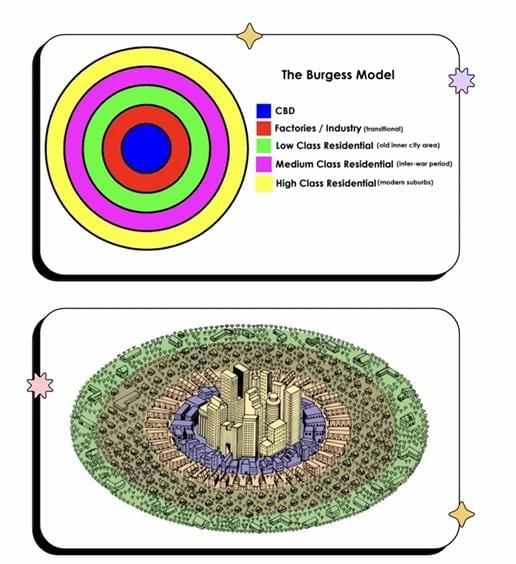
- The Concentric Zone Model, also referred to as the Burgess Model or Chicago School Model, is a framework in urban sociology that describes how cities grow and develop. It suggests that cities expand outward from a central business district (CBD) in a series of concentric rings, each representing a distinct stage of development.
- The model is based on the premise that cities follow a predictable growth pattern, with the most densely populated and developed areas at the center and less dense, less developed areas on the outskirts. It is often used to explain the distribution of social and economic groups within a city.
- Key points about the Concentric Zone Model include:
- The Concentric Zone Model, also known as the Burgess Model or Chicago School Model, is a framework for urban land use and social structure, developed by sociologist Ernest Burgess in the 1920s.
- It proposes that cities expand outward from a central business district in concentric zones, each with a unique character and social structure. The CBD is surrounded by inner-city neighborhoods, which are encircled by suburban neighborhoods.
- Inner-city neighborhoods are typically marked by high poverty, crime, and social disorganization, while suburban neighborhoods are characterized by affluence and social stability.
- The model suggests that social and economic traits are relatively uniform within each zone, with residents of a particular zone likely sharing similar backgrounds and lifestyles.
- Critics argue that the model oversimplifies the complex social and economic dynamics of urban areas and fails to adequately address racial and ethnic segregation.
Hoyt Sector Model
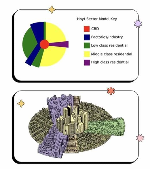
- The Hoyt Sector Model is a framework in urban sociology that describes city growth and development. Developed by urban planner Homer Hoyt in 1939, it was proposed as an alternative to the Concentric Zone Model, which was the prevailing model at the time.
- Unlike the Concentric Zone Model, which suggests cities grow in concentric circles, the Hoyt Sector Model posits that cities expand in a series of wedge-shaped sectors radiating from the central business district (CBD). The most densely populated and developed areas are near the center, with less dense areas on the outskirts.
- The model is frequently used to explain the spatial distribution of social and economic groups, with wealthier residents typically residing in inner sectors and poorer residents in outer sectors. It has significantly influenced urban sociology and the study of global city development.
- Key points about the Hoyt Sector Model include:
- The Hoyt Sector Model, developed by economist Homer Hoyt in the 1930s, proposes that cities grow outward from a CBD in sectors, each with a distinct character and social structure.
- It suggests that land use within a sector is determined by factors such as transportation accessibility, land availability, and social and economic influences.
- The central business district is considered the most desirable location for commercial activities due to its high accessibility and land value.
- Outer regions, with lower accessibility and land value, are less desirable for commercial activities and are typically dominated by residential land use.
- The model has been criticized for oversimplifying urban social and economic dynamics and for not adequately addressing racial and ethnic segregation.
Multiple Nuclei Model
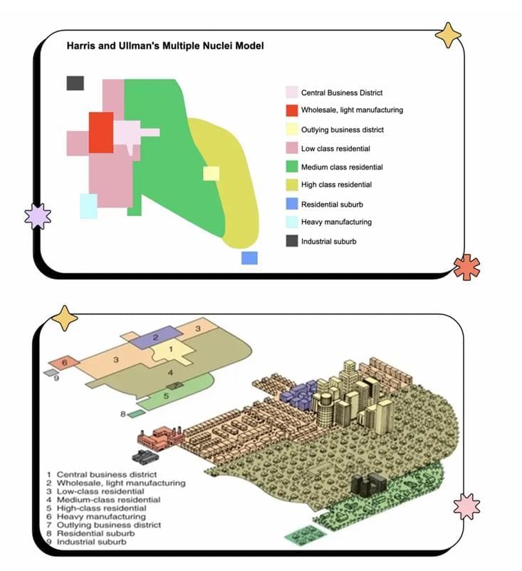
- The Multiple Nuclei Model is a framework in urban sociology that describes how cities grow and develop. Developed by urban planners Chauncy Harris and Edward Ullman in 1945, it offers an alternative to the Concentric Zone and Hoyt Sector Models, which were dominant at the time.
- Unlike models that assume cities grow from a single central business district (CBD) in concentric circles or sectors, the Multiple Nuclei Model suggests that cities develop around multiple centers, or nuclei, each with distinct characteristics and functions. It views cities as heterogeneous entities composed of varied zones with unique roles.
- The model is often used to explain the distribution of social and economic groups within a city and the connections between its various centers. It has been highly influential in urban sociology and the study of global urban development.
- Key points about the Multiple Nuclei Model include:
- The Multiple Nuclei Model, developed by geographer C.D. Harris and economist E.L. Ullman in 1945, proposes that cities consist of multiple centers or nuclei of land use rather than a single CBD.
- These nuclei may center around activities like commerce, industry, or transportation and vary in size and importance.
- The model suggests that land use and population distribution are influenced by transportation accessibility, land availability, and social and economic factors, not tied to a single nucleus.
- It emphasizes the interplay of multiple nuclei and the transportation networks connecting them as key determinants of urban structure.
- The model has shaped urban land use understanding and planning decisions but has been criticized for oversimplifying urban dynamics and neglecting racial and ethnic segregation.
Peripheral Model - “Edge Cities”
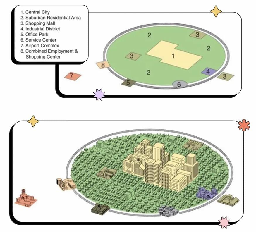
- The Peripheral Model, also known as the “Edge City” Model, is a framework in urban sociology that describes city growth and development. The term “edge city” was introduced by journalist Joel Garreau in his 1991 book, *Edge City: Life on the New Frontier*, which described a new type of urban development emerging on the outskirts of U.S. metropolitan areas.
- According to the Peripheral Model, edge cities are large, sprawling developments located on the peripheries of metropolitan areas, typically near major transportation corridors like highways and airports. These areas often feature a mix of residential, commercial, and industrial zones and are home to many white-collar workers who commute to central urban areas.
- Edge cities reflect the increasing decentralization of population and economic activity in metropolitan regions and are a defining feature of modern urban landscapes. They are typically less dense and more car-dependent than traditional cities, often lacking robust public transportation.
- The Peripheral Model describes concentrations of office, retail, and entertainment developments outside the central business district (CBD). Edge cities often emerge at major highway intersections due to the decentralization of jobs and population from urban cores.
- Key points about edge cities include:
- They are often located in suburban areas but can also appear in smaller towns or rural regions.
- They feature a mix of uses, such as offices, retail, and entertainment, and are highly car-dependent.
- They exhibit a more decentralized and dispersed development pattern compared to traditional CBDs.
- Edge cities are often self-contained, offering a range of amenities and services within their boundaries, reducing the need for residents to travel to the urban core.
- They can serve as regional centers, catering to a broad area beyond their immediate locality.
- They may compete with traditional downtowns by diverting investment and development but can also provide economic benefits and improve accessibility for residents living farther from city centers.
Summary
Urban sociology has developed several models to describe how cities grow and evolve. The most prominent models include:
- The Concentric Zone Model: This model suggests that cities expand outward from a central business district (CBD) in concentric circles, with the densest and most developed areas at the center and less dense areas on the outskirts.
- The Hoyt Sector Model: This model proposes that cities grow in wedge-shaped sectors radiating from a CBD, with denser, more developed areas near the center and less developed areas farther out.
- The Multiple Nuclei Model: This model posits that cities develop around multiple centers, or nuclei, each with distinct characteristics and functions.
- The Peripheral Model: Also known as the “edge city” model, it describes large, sprawling developments on metropolitan outskirts, marking a key feature of contemporary urban landscapes.
These models are valuable for understanding urban growth and change, illuminating the social, economic, and spatial patterns that define urban life.
Key Terms
- Burgess Model: The Burgess Model, or Concentric Zone Model, is a theoretical framework that divides cities into five concentric rings, each representing different land uses and socioeconomic statuses, illustrating how urban areas expand from the center outward.
- Central Business District (CBD): The Central Business District (CBD) is the commercial heart of a city, featuring a high concentration of retail, offices, and cultural institutions, with elevated land values and significant influence on urban development and economic activity.
- Chauncy Harris: Chauncy Harris was an American urban geographer known for co-developing the Multiple Nuclei Model, which describes cities growing around multiple centers rather than a single CBD, highlighting the complexity of urban spatial organization.
- Chicago School Model: The Chicago School Model is a framework from early 20th-century sociologists at the University of Chicago, emphasizing the interplay of social structures, spatial organization, and urban environments in shaping human behavior and community development.
- City Models: City models are theoretical frameworks that outline the spatial and social organization of urban areas, categorizing cities into zones or sectors to analyze growth patterns, land use, and socioeconomic dynamics.
- Concentric Zone Model: The Concentric Zone Model, developed by Ernest Burgess in the 1920s, describes urban land use as a series of concentric rings radiating from a central point, each with distinct functions and socioeconomic characteristics.
- Edge Cities: Edge cities are urban centers on the outskirts of traditional cities, characterized by concentrated retail, office, and entertainment facilities, reflecting shifts in urban development toward suburban areas.
- Edward Ullman: Edward Ullman was a geographer who co-developed the Multiple Nuclei Model, illustrating how cities grow around multiple centers, emphasizing the role of various factors in shaping urban spatial organization.
- Homer Hoyt: Homer Hoyt was an American urban planner and economist who developed the Sector Model in the 1930s, showing how cities expand in wedge-shaped sectors influenced by transportation and economic factors.
- Hoyt Sector Model: The Hoyt Sector Model, proposed by Homer Hoyt in 1939, suggests that cities develop in sectors rather than concentric circles, with land use shaped by transportation routes and socioeconomic factors.
- Joel Garreau: Joel Garreau is an American journalist and author known for introducing the concept of edge cities in his book *Edge City: Life on the New Frontier*, describing suburban areas evolving into vibrant economic and cultural hubs.
- Multiple Nuclei Model: The Multiple Nuclei Model, developed by Chauncy Harris and Edward Ullman in 1945, posits that cities grow around multiple centers, each with unique activities, reflecting the complexity of urban development.
- Peripheral Model: The Peripheral Model, or edge city model, describes urban areas organized around a CBD with surrounding suburbs and peripheral zones, often highlighting spatial segregation and varying access to resources.
The document The Internal Structure of Cities Chapter Notes | AP Human Geography - Grade 9 is a part of the Grade 9 Course AP Human Geography.
All you need of Grade 9 at this link: Grade 9
FAQs on The Internal Structure of Cities Chapter Notes - AP Human Geography - Grade 9
| 1. What are the main models used to explain the internal structure of cities? |  |
Ans. The main models used to explain the internal structure of cities include the Concentric Zone Model, the Sector Model, and the Multiple Nuclei Model. The Concentric Zone Model, developed by sociologist Ernest Burgess, suggests that cities grow in rings around a central point. The Sector Model, proposed by Homer Hoyt, indicates that cities develop in sectors or wedges, often following transportation routes. The Multiple Nuclei Model, created by Chauncy Harris and Edward Ullman, argues that cities have multiple centers or nuclei that influence their growth and function.
| 2. How does urbanization affect the internal structure of cities? | |
Ans. Urbanization significantly changes the internal structure of cities by increasing population density and leading to the expansion of urban areas. This process can result in the development of new residential and commercial areas, often leading to suburbanization as people move away from city centers. Urbanization also impacts transportation infrastructure, public services, and land use, contributing to challenges such as traffic congestion, pollution, and the need for affordable housing.
| 3. What role do socio-economic factors play in the internal structure of cities? | |
Ans. Socio-economic factors play a crucial role in shaping the internal structure of cities. Income levels, education, and employment opportunities can influence where people choose to live. Wealthier populations often reside in suburban or central areas, while lower-income groups may be concentrated in specific zones, often near industrial areas or less desirable neighborhoods. These socio-economic disparities can lead to issues related to segregation, access to services, and overall quality of life within the urban environment.
| 4. What are the implications of the internal structure of cities for urban planning? | |
Ans. The internal structure of cities has significant implications for urban planning. Understanding the various models of urban structure allows planners to make informed decisions about land use, transportation, and public services. Effective urban planning can help mitigate issues such as traffic congestion, environmental degradation, and social inequality. Additionally, recognizing the unique characteristics of different urban areas enables planners to promote sustainable development and improve the overall quality of urban life.
| 5. How does transportation influence the internal structure of cities? | |
Ans. Transportation plays a vital role in shaping the internal structure of cities by determining accessibility and connectivity. Efficient transportation systems can facilitate the movement of people and goods, influencing where businesses and residences are located. Areas with good transportation links tend to attract more development, while regions that are poorly connected may experience urban decline. As cities expand, the demand for transportation infrastructure also grows, necessitating ongoing investment and planning to ensure effective urban mobility.
About this Document

Oct 11, 2025
Last updated
Related Exams
Document Description: Chapter Notes: The Internal Structure of Cities for Grade 9 2025 is part of AP Human Geography preparation.
The notes and questions for Chapter Notes: The Internal Structure of Cities have been prepared according to the Grade 9 exam syllabus. Information about Chapter Notes: The Internal Structure of Cities covers topics
like Introduction, City Models and Chapter Notes: The Internal Structure of Cities Example, for Grade 9 2025 Exam. Find important definitions, questions, notes, meanings, examples, exercises and tests below for Chapter Notes: The Internal Structure of Cities.
Introduction of Chapter Notes: The Internal Structure of Cities in English is available as part of our AP Human Geography
for Grade 9 & Chapter Notes: The Internal Structure of Cities in Hindi for AP Human Geography course.
Download more important topics related with notes, lectures and mock test series for Grade 9
Exam by signing up for free. Grade 9: The Internal Structure of Cities Chapter Notes | AP Human Geography - Grade 9
Description
Full syllabus notes, lecture & questions for The Internal Structure of Cities Chapter Notes | AP Human Geography - Grade 9 - Grade 9 | Plus excerises question with solution to help you revise complete syllabus for AP Human Geography | Best notes, free PDF download
Information about Chapter Notes: The Internal Structure of Cities
In this doc you can find the meaning of Chapter Notes: The Internal Structure of Cities defined & explained in the simplest way possible. Besides explaining types of
Chapter Notes: The Internal Structure of Cities theory, EduRev gives you an ample number of questions to practice Chapter Notes: The Internal Structure of Cities tests, examples and also practice Grade 9
tests

Related Searches
Sample Paper
,shortcuts and tricks
,Important questions
,Objective type Questions
,practice quizzes
,Summary
,Semester Notes
,Previous Year Questions with Solutions
,ppt
,study material
,past year papers
,The Internal Structure of Cities Chapter Notes | AP Human Geography - Grade 9
,Free
,MCQs
,Exam
,Extra Questions
,The Internal Structure of Cities Chapter Notes | AP Human Geography - Grade 9
,mock tests for examination
,video lectures
,Viva Questions
,The Internal Structure of Cities Chapter Notes | AP Human Geography - Grade 9
;


Additional Information about Chapter Notes: The Internal Structure of Cities for Grade 9 Preparation
Chapter Notes: The Internal Structure of Cities Free PDF Download
The Chapter Notes: The Internal Structure of Cities is an invaluable resource that delves deep into the core of the Grade 9 exam.
These study notes are curated by experts and cover all the essential topics and concepts, making your preparation more efficient and effective.
With the help of these notes, you can grasp complex subjects quickly, revise important points easily,
and reinforce your understanding of key concepts. The study notes are presented in a concise and easy-to-understand manner,
allowing you to optimize your learning process. Whether you're looking for best-recommended books, sample papers, study material,
or toppers' notes, this PDF has got you covered. Download the Chapter Notes: The Internal Structure of Cities now and kickstart your journey towards success in the Grade 9 exam.
Importance of Chapter Notes: The Internal Structure of Cities
The importance of Chapter Notes: The Internal Structure of Cities cannot be overstated, especially for Grade 9 aspirants.
This document holds the key to success in the Grade 9 exam.
It offers a detailed understanding of the concept, providing invaluable insights into the topic.
By knowing the concepts well in advance, students can plan their preparation effectively.
Utilize this indispensable guide for a well-rounded preparation and achieve your desired results.
Chapter Notes: The Internal Structure of Cities
Chapter Notes: The Internal Structure of Cities Notes offer in-depth insights into the specific topic to help you master it with ease.
This comprehensive document covers all aspects related to Chapter Notes: The Internal Structure of Cities.
It includes detailed information about the exam syllabus, recommended books, and study materials for a well-rounded preparation.
Practice papers and question papers enable you to assess your progress effectively.
Additionally, the paper analysis provides valuable tips for tackling the exam strategically.
Access to Toppers' notes gives you an edge in understanding complex concepts.
Whether you're a beginner or aiming for advanced proficiency, Chapter Notes: The Internal Structure of Cities Notes on EduRev are your ultimate resource for success.
Chapter Notes: The Internal Structure of Cities Grade 9 Questions
The "Chapter Notes: The Internal Structure of Cities Grade 9 Questions" guide is a valuable resource for all aspiring students preparing for the
Grade 9 exam. It focuses on providing a wide range of practice questions to help students gauge
their understanding of the exam topics. These questions cover the entire syllabus, ensuring comprehensive preparation.
The guide includes previous years' question papers for students to familiarize themselves with the exam's format and difficulty level.
Additionally, it offers subject-specific question banks, allowing students to focus on weak areas and improve their performance.
Study Chapter Notes: The Internal Structure of Cities on the App
Students of Grade 9 can study Chapter Notes: The Internal Structure of Cities alongwith tests & analysis from the EduRev app,
which will help them while preparing for their exam. Apart from the Chapter Notes: The Internal Structure of Cities,
students can also utilize the EduRev App for other study materials such as previous year question papers, syllabus, important questions, etc.
The EduRev App will make your learning easier as you can access it from anywhere you want.
The content of Chapter Notes: The Internal Structure of Cities is prepared as per the latest Grade 9 syllabus.
|
© EduRev
|
Education Revolution
|


|


Signup to see your scores
go up within 7 days!
Access 1000+ FREE Docs, Videos and Tests
Takes less than 10 seconds to signup