Assertion & Reason Type Questions: India - Size and Location

Directions: In the questions given below, there are two statements marked as Assertion (A) and Reason (R). Read the statements and choose the correct option:
Q1: Assertion (A): India lies entirely in the Northern Hemisphere.
Reason (R): The mainland of India extends between latitudes 8°4′N and 37°6′N.
(a) Both A and R are true and R is the correct explanation of A.
(b) Both A and R are true but R is not the correct explanation of A.
(c) A is correct but R is wrong.
(d) A is wrong but R is correct.
Ans: (a)
India is entirely in the Northern Hemisphere, as its latitudinal extent (8°4′N to 37°6′N) lies north of the equator. The reason correctly explains the assertion.
Q2: Assertion (A): The Tropic of Cancer divides India into almost two equal parts.
Reason (R): The Tropic of Cancer passes through Odisha.
(a) Both A and R are true and R is the correct explanation of A.
(b) Both A and R are true but R is not the correct explanation of A.
(c) A is correct but R is wrong.
(d) A is wrong but R is correct.
Ans: (c)
The Tropic of Cancer (23°30′N) does divide India into nearly equal parts, but it does not pass through Odisha. Thus, A is correct, but R is wrong.
A picture showing Tropic of Cancer divides India in almost two equal parts.
Q3: Assertion (A): India has a time lag of two hours from Gujarat to Arunachal Pradesh.
Reason (R): The Standard Meridian of India is 82°30′E, passing through Mirzapur.
(a) Both A and R are true and R is the correct explanation of A.
(b) Both A and R are true but R is not the correct explanation of A.
(c) A is correct but R is wrong.
(d) A is wrong but R is correct.
Ans: (a)
The longitudinal extent of India causes a time difference of about two hours between Gujarat and Arunachal Pradesh. The Standard Meridian (82°30′E) ensures a single standard time, explaining why the time lag exists but is standardized.
Q4: Assertion (A): India's coastline is longer than its land boundary.
Reason (R): India's total coastline, including Andaman and Nicobar and Lakshadweep, is 7,516.6 km, while its land boundary is 15,200 km.
(a) Both A and R are true and R is the correct explanation of A.
(b) Both A and R are true but R is not the correct explanation of A.
(c) A is correct but R is wrong.
(d) A is wrong but R is correct.
Ans: (d)
The assertion is incorrect because India's land boundary (15,200 km) is longer than its coastline (7,516.6 km). The reason is factually correct as it provides the accurate figures.
Q5: Assertion (A): India's central location in the Indian Ocean is strategically significant.
Reason (R): The Deccan Peninsula protrudes into the Indian Ocean, facilitating trade with West Asia, Africa, and Europe.
(a) Both A and R are true and R is the correct explanation of A.
(b) Both A and R are true but R is not the correct explanation of A.
(c) A is correct but R is wrong.
(d) A is wrong but R is correct.
Ans: (a)
India's central location at the head of the Indian Ocean is strategically important, and the Deccan Peninsula's protrusion enhances trade connectivity, explaining the assertion.
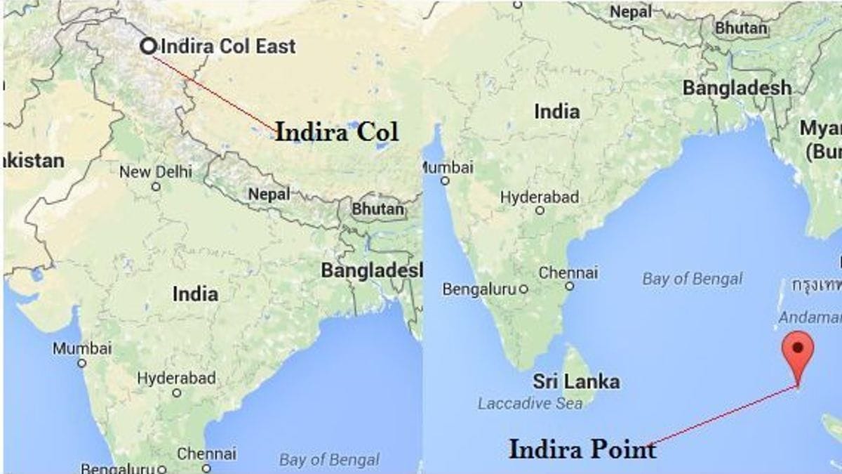
Q6: Assertion (A): The southernmost point of the Indian Union is Indira Point.
Reason (R): Indira Point is located in the Lakshadweep Islands.
(a) Both A and R are true and R is the correct explanation of A.
(b) Both A and R are true but R is not the correct explanation of A.
(c) A is correct but R is wrong.
(d) A is wrong but R is correct.
Ans: (c)
Indira Point is the southernmost point of India, but it is located in the Andaman and Nicobar Islands, not Lakshadweep. Thus, A is correct, but R is wrong.
Q7: Assertion (A): The east-west extent of India appears smaller than the north-south extent.
Reason (R): Both the latitudinal and longitudinal extents of India's mainland are about 30°.
(a) Both A and R are true and R is the correct explanation of A.
(b) Both A and R are true but R is not the correct explanation of A.
(c) A is correct but R is wrong.
(d) A is wrong but R is correct.
Ans: (a)
Despite similar latitudinal and longitudinal extents (~30°), the east-west extent appears smaller due to the Earth's curvature, which the reason explains.
Q8: Assertion (A): India shares its land boundaries with seven countries.
Reason (R): India's southern neighbors, Sri Lanka and Maldives, are separated by sea.
(a) Both A and R are true and R is the correct explanation of A.
(b) Both A and R are true but R is not the correct explanation of A.
(c) A is correct but R is wrong.
(d) A is wrong but R is correct.
Ans: (b)
India shares land boundaries with seven countries (Pakistan, Afghanistan, China, Nepal, Bhutan, Myanmar, Bangladesh). The reason is true about Sri Lanka and Maldives but does not explain the number of land boundaries.
Q9: Assertion (A): The duration of day and night varies significantly in Kashmir but not in Kanyakumari.
Reason (R): Kanyakumari is closer to the equator than Kashmir.
(a) Both A and R are true and R is the correct explanation of A.
(b) Both A and R are true but R is not the correct explanation of A.
(c) A is correct but R is wrong.
(d) A is wrong but R is correct.
Ans: (a)
The variation in day and night duration is less at Kanyakumari (near the equator) compared to Kashmir (farther north), as the reason explains.
Q10: Assertion (A): The Suez Canal reduced India's distance from Europe by 7,000 km.
Reason (R): The Suez Canal connects the Mediterranean Sea to the Red Sea.
(a) Both A and R are true and R is the correct explanation of A.
(b) Both A and R are true but R is not the correct explanation of A.
(c) A is correct but R is wrong.
(d) A is wrong but R is correct.
Ans: (b)
The Suez Canal did reduce India's distance from Europe by about 7,000 km, and it connects the Mediterranean Sea to the Red Sea. However, the reason does not directly explain the distance reduction.
FAQs on Assertion & Reason Type Questions: India - Size and Location
| 1. What are the key geographical features that define India's location? |  |
| 2. How does India's size compare to other countries in the world? | |
| 3. What is the significance of India's location in relation to its neighbors? | |
| 4. What role does the Tropic of Cancer play in India's geography? | |
| 5. How does the Indian subcontinent's geographical location influence its climate? | |


