Important Formulas: Maps and Locations | Mathematics (Maths Mela) Class 5 - New NCERT PDF Download
| Table of contents |
|
| Finding Directions: Using the Sun |
|
| What is a Compass? |
|
| Maps |
|
| Keys/Legends in a Map |
|
| Shortest Route |
|
| Coordinates |
|

Finding Directions: Using the Sun
Face the rising sun → you face East.
Stretch out your arms:
Left hand → North
Right hand → South
Behind you → West
These are the four cardinal directions.
Example: Manu is facing the rising sun → East.
Left hand → North
Right hand → South
Behind → West
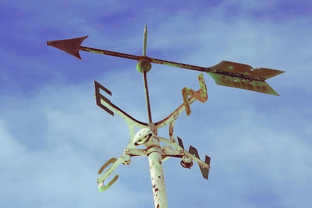
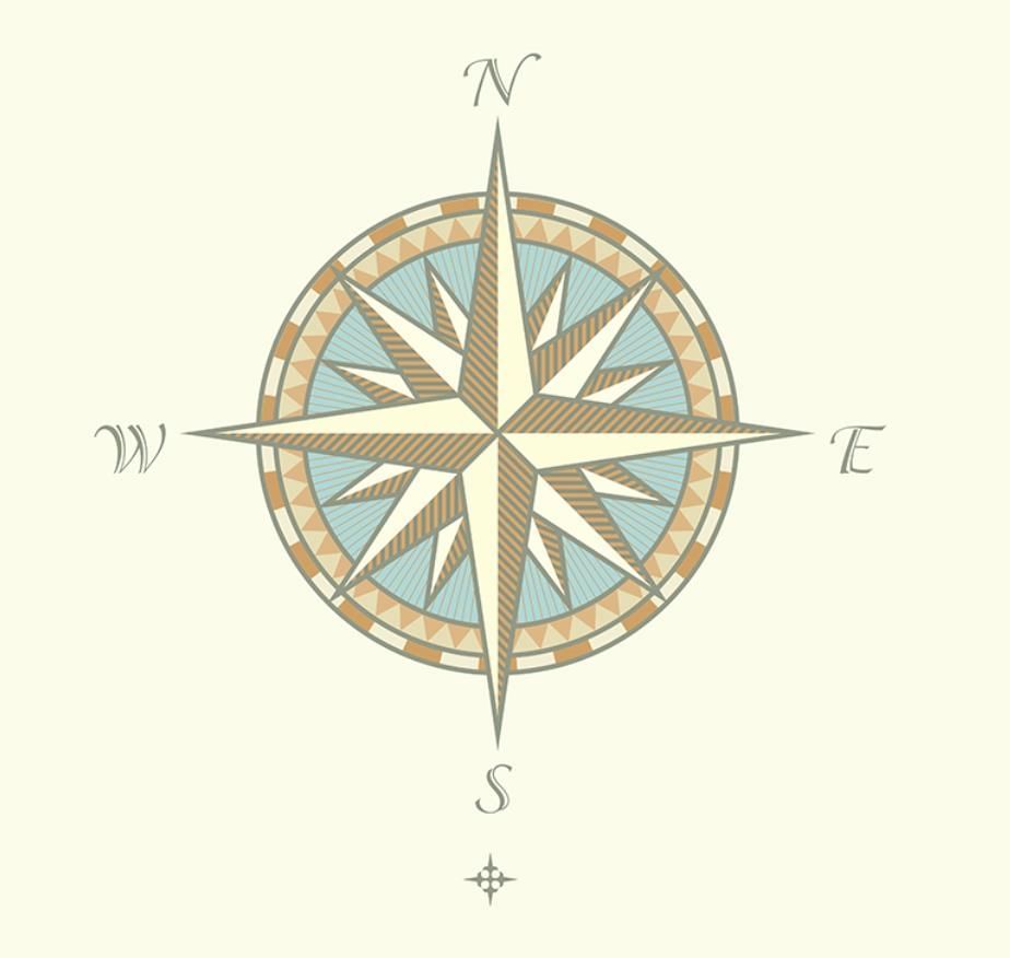
What is a Compass?
A compass is a tool to find directions.
It has a magnetic needle that always points North.
Once North is known, we can find South, East, and West.
Used by travelers, sailors, hikers, and explorers.
Maps
A map is a special drawing that shows places.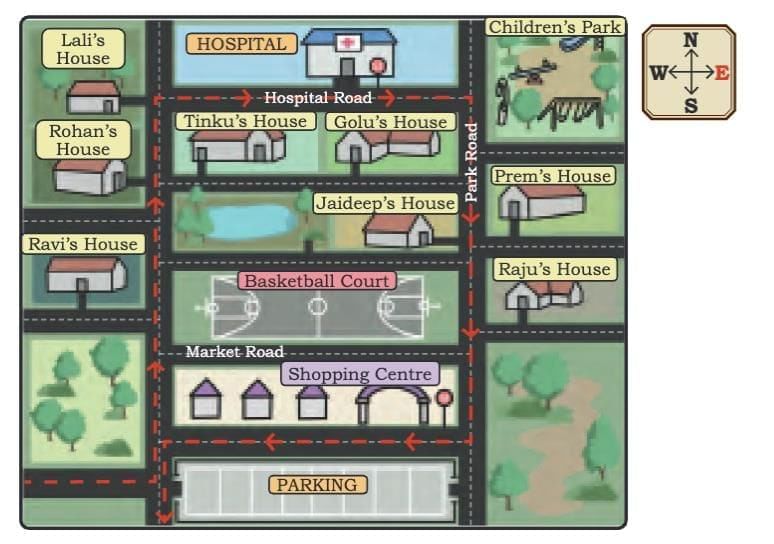
Maps show:
Places: houses, roads, parks, shops, monuments
Symbols: small pictures or signs
Directions: arrow showing North (N)
Routes: paths or roads
Key/Legend: explains symbols
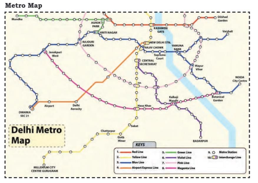
Keys/Legends in a Map
A Key/Legend explains symbols on a map.
Example: Metro map with colored lines.
Shortest Route
Sometimes many roads lead to the same place.
The shortest route saves time and effort.
Example:
Route A → B → C (longer)
Route A → C (straight, shorter)
Coordinates
Coordinates locate exact positions on a grid/map. Written as (x, y).
x = horizontal (row)
y = vertical (column)
Solved Examples
Example 1: In a map, the scale is 1 cm of map = 5 km on Earth, then fill in the blank.
13 cm = ……….. km.
Sol: Follow the same method of the solved example given above,
1 cm = 5 km
13 cm = ? km
13 * 5 = 65 km
Example 2: From the image, the largest distance between A and B is in Map - 1 or Map - 2.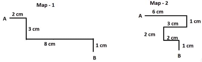
Sol: Let us first calculate the distance between A and B in Map - 1 and 2
Distance in Map - 1 = 2 cm + 3 cm + 8 cm + 1 cm = 14 cm
Distance in Map - 2 = 6 cm + 1 cm + 3 cm + 2 cm + 2 cm + 1 cm = 15 cm
Hence from both the distances, we can say that distance in Map - 2 is the largest.
Example 3: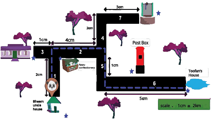
Now let us answer some questions with reference to the above image,
Q1: What is the path taken by Panda?
Sol: The path chosen by Panda on the map is along 1, 2, 5, and 6. Panda starts at Bheem Uncle's house, then goes along with Appu Confectionery, then crosses Post Box and reaches Toofan’s house.
Q2: Find the distance from Bheem's uncle's house to Toofan's house. (Hint: Distance is the length between two points.)
Sol: To find the distance, let us first add the total scale from Bheem's uncle's house to Toofan’s House. Follow paths 1, 2, 5, and 6 on the map.
2 cm + 4 cm + 1 cm + 5 cm
From the scale it is given that 1 cm = 2 km. Hence we should replace the 1 cm value with 2 km.
Hence we can write the scale values as,
2 cm = 1 cm + 1 cm = 2 km + 2 km = 4 km
4 cm = 1 cm + 1 cm + 1 cm + 1 cm = 2 km + 2 km + 2 km + 2 km = 8 km
1 cm = 2 km
5 cm = 1 cm + 1 cm + 1 cm + 1 cm + 1 cm = 2 km + 2 km + 2 km + 2 km + 2 km = 10 km
Now let us add all the values,
4 km + 8 km + 2 km + 10 km
24 km
Q3: From the map which is the longest road?
Sol: By looking at the map we can say that the largest scale number in the path chosen by Panda is the longest road. Hence 5 cm is the largest number, number 6 is the longest road.
|
35 videos|276 docs|7 tests
|
FAQs on Important Formulas: Maps and Locations - Mathematics (Maths Mela) Class 5 - New NCERT
| 1. What is the purpose of a compass and how does it work? |  |
| 2. How do maps help in navigation and what are their components? | |
| 3. What is a key or legend in a map, and why is it important? | |
| 4. How can one determine the shortest route on a map? | |
| 5. What are coordinates, and how are they used in mapping locations? | |


shortcuts and tricks
,Important Formulas: Maps and Locations | Mathematics (Maths Mela) Class 5 - New NCERT
,past year papers
,Free
,Important Formulas: Maps and Locations | Mathematics (Maths Mela) Class 5 - New NCERT
,Semester Notes
,Objective type Questions
,Important questions
,Summary
,Viva Questions
,Extra Questions
,ppt
,mock tests for examination
,study material
,MCQs
,Previous Year Questions with Solutions
,video lectures
,Important Formulas: Maps and Locations | Mathematics (Maths Mela) Class 5 - New NCERT
,Sample Paper
,practice quizzes
,Exam
;


Important Formulas: Maps and Locations Free PDF Download
Importance of Important Formulas: Maps and Locations
Important Formulas: Maps and Locations Notes
Important Formulas: Maps and Locations Class 5 Questions
Study Important Formulas: Maps and Locations on the App
|
© EduRev
|
Education Revolution
|


|


