Traversing | Civil Engineering SSC JE (Technical) - Civil Engineering (CE) PDF Download

Surveying (Part 3)
Compass Surveying
Compass surveying: The branch of surveying in which directions of survey lines are determined by a complex and their lengths by chaining or taping directly on the surface of the earth, is called compass surveying.
Before recommending the compass survey for any area, it must be ascertained that area is not magnetically disturbed.
Traverse : A series of connected straight lines each joining two points on the ground, is called a traverse.
End points are known as traverse stations and straight lines between two consecutive stations, are called traverse legs.
Traverses may be either a closed traverse or an open traverse.
Closed traverse : A surveying traverse whose accuracy can be checked by the fact that, when it is closed, the angles should add up to 360 degrees , and which ends at its starting point.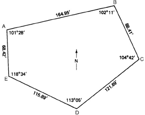
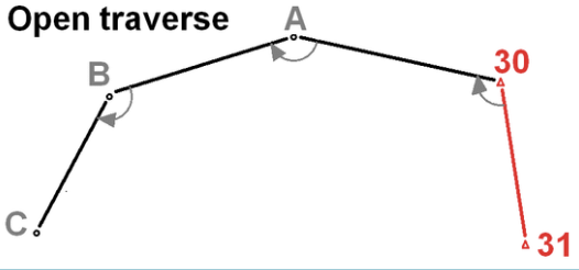
Open traverse : The traverse which neither returns to its starting station nor closes on any other known station, is called an open traverse.
Classification of traverses based on instruments used :
- Chain traversing
- Compass traversing
- Plane table travelling
- Theodolite traversing
- Tacheometric traversing
Chain traversing or chain angles method: In chain traversing the entire work is done by a chain or tape and no angle measuring instrument is needed. The angle computed by the measurements, is known as a chain angle.
Compass traversing: The traverse in which angular measurements are made with a surveying compass, is know as compass traversing. The traverse angle between two consecutive legs is computed by observing the magnetic bearing of the sides.
Plane table traversing: The traverse in which angular measurements between the traverse sides are plotted graphically on a plane table with the help of an alidade, is know as plane table traversing.
Theodolite traversing: The traverse in which angular measurements between traverse sides are made with a theodolite, is known as theodolite traversing.
Tacheometric traversing: The traverse in which direct measurements of traverse sides by chaining is dispensed and these are obtained by making observations with a tacheometer, is known as tacheometric traversing.
Surveying Compass :
The surveying compasses are of two types:
(1) Prismatic compass’
(2) Surveyor’s compass
Surveyor’s Compass:
(i)Graduation circle is fixed to the box. Hence, it rotates with the line of sight.
(ii)At viewing end there is no prism. There is only a slit.
(iii)Sighting and viewing cannot be done simultaneously.
(iv)Magnetic needle acts as index while reading.
(v)The graduations are in quadrantal system.
(vi)Graduations are marked directly. They are not inverted.
(vii)The reading is taken by directly viewing from top glass.
(viii)Tripod is essential for using it.
Prismatic Compass:
(i)Graduation circle is fixed to broad type needle. Hence, it will not rotate with the line of sight.
(ii)There is a prism at viewing end.
(iii)Sighting and reading can be done simultaneously.
(iv)The magnetic needle do not act as an index.
(v)The graduations are in whole circle bearing.
(vi)Graduations are marked inverted since its reflection is read through prism.
(vii)The reading is taken through a prism.
(vii)Tripod may or may not be used. It can be held on a stretched hand also.
Meridian : The fixed direction on the surface of the earth with reference to which, bearing survey lines are expressed, is called a meridian.
|
2 videos|133 docs|55 tests
|
FAQs on Traversing - Civil Engineering SSC JE (Technical) - Civil Engineering (CE)
| 1. What is compass surveying and how is it used in traversing? |  |
| 2. What are the main advantages of using compass surveying over other methods? | |
| 3. How do you perform a compass survey? | |
| 4. What are the common errors encountered in compass surveying and how can they be minimized? | |
| 5. How can compass surveying be integrated with modern technology for better results? | |


Free
,practice quizzes
,Exam
,Objective type Questions
,video lectures
,Sample Paper
,Traversing | Civil Engineering SSC JE (Technical) - Civil Engineering (CE)
,Previous Year Questions with Solutions
,shortcuts and tricks
,Traversing | Civil Engineering SSC JE (Technical) - Civil Engineering (CE)
,Traversing | Civil Engineering SSC JE (Technical) - Civil Engineering (CE)
,ppt
,mock tests for examination
,Summary
,MCQs
,past year papers
,Semester Notes
,study material
,Important questions
,Extra Questions
,Viva Questions
;


Traversing Free PDF Download
Importance of Traversing
Traversing Notes
Traversing Civil Engineering (CE) Questions
Study Traversing on the App
|
© EduRev
|
Education Revolution
|


|


