UPSC Exam  >  UPSC Tests  >  Test: Geography NCERT Based Test - 1 - UPSC MCQ

Test: Geography NCERT Based Test - 1 - UPSC MCQ


Test Description

25 Questions MCQ Test - Test: Geography NCERT Based Test - 1

Test: Geography NCERT Based Test - 1 for UPSC 2024 is part of UPSC preparation. The Test: Geography NCERT Based Test - 1 questions and answers have been prepared according to the UPSC exam syllabus.The Test: Geography NCERT Based Test - 1 MCQs are made for UPSC 2024 Exam. Find important definitions, questions, notes, meanings, examples, exercises, MCQs and online tests for Test: Geography NCERT Based Test - 1 below.
Solutions of Test: Geography NCERT Based Test - 1 questions in English are available as part of our course for UPSC & Test: Geography NCERT Based Test - 1 solutions in Hindi for UPSC course. Download more important topics, notes, lectures and mock test series for UPSC Exam by signing up for free. Attempt Test: Geography NCERT Based Test - 1 | 25 questions in 30 minutes | Mock test for UPSC preparation | Free important questions MCQ to study for UPSC Exam | Download free PDF with solutions
Test: Geography NCERT Based Test - 1 - Question 1

Consider the following statements about the geographical extension of India:
1. The mainland of India extends from Kashmir in the north to Kanyakumari in the south and Assam in the east to Gujarat in the west.
2. The territorial limit extends towards the sea up to 12 nautical miles from the coast.

Which of the above statements is/are correct? 

Detailed Solution for Test: Geography NCERT Based Test - 1 - Question 1

Statement 1 is incorrect: The mainland of India extends from Kashmir in the north to Kanyakumari in the south and Arunachal Pradesh in the east to Gujarat in the west.

Supplementary notes:

India as a geographical unit

  • The mainland of India extends from Kashmir in the north to Kanyakumari in the south and Arunachal Pradesh in the east to Gujarat in the west.
  • India’s territorial limit further extends towards the sea upto 12 nautical miles (about 21.9 km) from the coast.
  • Our southern boundary extends upto 6°45’ N latitude in the Bay of Bengal.
  • The latitudinal and longitudinal extent of India are roughly about 30 degrees, whereas the actual distance measured from north to south extremity is 3,214 km, and that from east to west is only 2,933 km.
Test: Geography NCERT Based Test - 1 - Question 2

Consider the following statements:
1. The Danube is the longest river in Europe flowing through 10 countries
2. The highest mountain of Europe, Mount Elbruz, a dormant volcano, is located in the Caucasus range. 

Which of the above statements is/are correct?

Detailed Solution for Test: Geography NCERT Based Test - 1 - Question 2

The Volga is the longest River in Continental Europe. The Volga starts and ends in Russia. Danube is the second longest river in Europe.

1 Crore+ students have signed up on EduRev. Have you? Download the App
Test: Geography NCERT Based Test - 1 - Question 3

We always see the same face of the moon because

Detailed Solution for Test: Geography NCERT Based Test - 1 - Question 3

We always see the same face of the moon because it takes equal time for revolution around the earth and rotation on its axis.

Test: Geography NCERT Based Test - 1 - Question 4

Match the following:

Select the correct answer using the code given below:
Detailed Solution for Test: Geography NCERT Based Test - 1 - Question 4
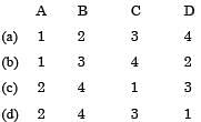
  • Option (d) is correct:

Supplementary notes: 

Volcano

  • A volcano is a place where gases, ashes and/ or molten rock material ‘lava’ escape to the ground through fissures and faults, etc.
  • It is from asthenosphere that the molten rock materials fin d their way to the surface.
  • If the materials remain below the surface, it is called magma.
  • If the materials find a way to come out on the surface, it is called lava.
  • These magma and lava form different types of structure called Volcanic Landforms. These landforms can be extrusive, or intrusive.

Extrusive Landforms

  • The structure formed by Lava and other materials such as Ashes and Pyroclastic materials is called extrusive landforms. These include Shield Volcano, Composite Volcano, Caldera, and Flood Basalt Province, etc.
  • The Shield Volcanoes are formed if the lava has low viscosity. Hence, they are not steep. After the Basalt province, the shield volcanoes are the largest of all the volcanoes. Examples are Mauna Loa, Hawaiian Islands, USA, and Galapagos Islands.
  • Composite Volcanoes form in many years after multiple eruptions. These volcanoes contain pyroclastic materials and ashes other than the thick and highly viscous magmatic lava. Examples are Mount Kilimanjaro and Mount St. Helens.
  • When a large amount of magma erupts in a short time the rock underlying the magma collapses. This result in depressions, called Caldera. These are the most explosive in nature.
  • Highly fluid lava, made of basalt when erupting on the surface, it forms a flood basaltic province. The Deccan Trap is one such example.

Intrusive landforms

  • When the magma remains within the lithosphere, cools over there and forms different types of structure, are called intrusive landforms. These include Lacoliths, Phacoliths, Lapoliths, Sills, Dykes, and Batholiths, etc. 
  • Large bodies of magmatic material that cools in the deeper depth of the crust and develop in the form of large domes are Batholiths. These are the cooled portion of magma chambers.
  • Lacoliths are large dome-shaped intrusive bodies with a level base and connected by a pipe-like conduit from below.
  • When the lava makes its way through cracks and the fissures developed in the land, it solidifies almost perpendicular to the ground. It gets cooled in the same position to develop a wall-like structure. Such structures are called dykes. These are the most commonly found intrusive forms in the western Maharashtra area.
  • Sills, unlike dykes, are thin horizontal intrusive igneous landform.
  • Lapoliths are intrusive volcanic landforms having saucer shape and concave to the sky.
Test: Geography NCERT Based Test - 1 - Question 5

Which of the following is a major impact/effect of salinization on irrigated lands?

Detailed Solution for Test: Geography NCERT Based Test - 1 - Question 5

Excess irrigation causes salinization due to capillary action. Excess water causes logging and salinization which in turn fills the air spaces in the soil with water. The process does make the soil impermeable but only gradually.

Test: Geography NCERT Based Test - 1 - Question 6

Monsoon is active for about six months in Kerala and for less than three Months in Rajasthan because

Detailed Solution for Test: Geography NCERT Based Test - 1 - Question 6

Kerala is in the southern part of the Western coast of India where summer monsoon reaches first. In contrast, Rajasthan is located far away from the sea where monsoon reaches in the last and retreat the earliest.

Test: Geography NCERT Based Test - 1 - Question 7

Which of the following is not an indirect source for studying Earth’s interior?

Detailed Solution for Test: Geography NCERT Based Test - 1 - Question 7

Option (c) is correct:
Volcanic eruption is a direct source to study Earth’s interior.

Supplementary notes:

Sources for studying Earth’s interior

  • There are 2 types of sources to study Earth’s interior- Direct and Indirect.

Direct Sources

  • Most of our knowledge about the interior of the earth is largely based on estimates and inferences. Yet, a part of the information is obtained through direct observations and analysis of materials.
  • Volcanic eruption forms another source of obtaining direct information. As and when the molten material (magma) is thrown onto the surface of the earth, during volcanic eruption it becomes available for laboratory analysis.

Indirect Sources

  • Gravitation is an indirect source. The gravitation force (g) is not the same at different latitudes on the surface. It is greater near the poles and less at the equator. This is because of the distance from the center at the equator being greater than that at the poles. The gravity values also differ according to the mass of material. Gravity anomalies give us information about the distribution of mass of the material in the crust of the earth.
  • Seismic activity is one of the most important sources of information about the interior of the earth. The study of seismic waves provides a complete picture of the layered interior.
  • Mining activity is both a direct as well as an indirect source for Earth’s interior. The most easily available solid earth material is surface rock or the rocks we get from mining areas. Besides mining, scientists have taken up a number of projects like “Deep Ocean Drilling Project” and “Integrated Ocean Drilling Project”. These have provided large volume of information through the analysis of materials collected at different depths. Mining is also an indirect source as we can analyze the properties of matter at different depths. We know through the mining activity that temperature and pressure increase with the increasing distance from the surface towards the interior in deeper depths. Moreover, it is also known that the density of the material also increases with depth.
  • Other important indirect sources are meteors and magnetic field.
Test: Geography NCERT Based Test - 1 - Question 8

Consider the given statements regarding Karst topography:
1. A region with a large stretch of limestone topography is termed as a Karst region
2. The name Karst is derived from the Karst district of Yugoslavia on the Adriatic Sea
3. A Karst topography is characterized by surface drainage system with sinkhole and caves
4. Karst regions have bleak landscape usually broken by precipitous slopes

Which of the above statements is/are correct?

Detailed Solution for Test: Geography NCERT Based Test - 1 - Question 8

Karst topography is characterized by underground drainage system.

Test: Geography NCERT Based Test - 1 - Question 9

Occlusion implies _______ of a cyclone

Detailed Solution for Test: Geography NCERT Based Test - 1 - Question 9

Occlusion of the cyclone occurs when the cold air masses moving faster than the warm airmasses overtakes the later and thus it implies the complete upliftment of the warm air mass and the warm and the warm front from the ground. Thus after occlusion, the cyclone starts dissipating from the ground.

Test: Geography NCERT Based Test - 1 - Question 10

Which of the following does not come under Rapid Movements?

Detailed Solution for Test: Geography NCERT Based Test - 1 - Question 10

Option (c) is correct: Solifluction is a slow movement

Supplementary notes:

Rapid Movements

  • These movements are most prevalent in humid climatic regions and occur over gentle to steep slopes.
  • Movement of water-saturated clayey or silty earth materials down low angle terraces or hillsides is known as earthflow. Quite often, the materials slump making step-like terraces and leaving arcuate scarps at their heads and an accumulation bulge at the toe. When slopes are steeper, even the bedrock, especially of soft sedimentary rocks like shale or deeply weathered igneous rock, may slide downslope.
  • Another type in this category is mudflow. In the absence of vegetation cover and with heavy rainfall, thick layers of weathered materials get saturated with water and either slowly or rapidly flows down along definite channels.
  • It looks like a stream of mud within a valley. Mudflows occur frequently on the slopes of erupting or recently erupted volcanoes.
  • Volcanic ash, dust, and other fragments turn into mud due to heavy rains and flow down as tongues or streams of mud causing great destruction to human habitations.
  • A third type is the debris avalanche, which is more characteristic of humid regions with or without vegetation cover and occurs in narrow tracks on steep slopes. This debris avalanche can be much faster than the mudflow. Debris avalanche is similar to snow avalanche.
Test: Geography NCERT Based Test - 1 - Question 11

Which of the following statements regarding westerlies is not correct?

Detailed Solution for Test: Geography NCERT Based Test - 1 - Question 11

They cause rainfall on the western margin of the continents since they below from west to east, in both the hemisphere and pick up moisture from the water bodies on the western sides and thereby causing rainfall on the western margins.

Test: Geography NCERT Based Test - 1 - Question 12

Which part of India receives rainfall both from Bay of Bengal and Arabian Sea branch of Summer Monsoon?

Detailed Solution for Test: Geography NCERT Based Test - 1 - Question 12

Punjab-Haryana plains are almost equidistant from both the Bay of Bengal and the Arabian Sea. Further, the direction of both the branches of monsoon winds is oriented towards the Punjab, Haryana plain and hence this area receives rainfall from both the branches.

Test: Geography NCERT Based Test - 1 - Question 13

Consider the following statements regarding Atmospheric Pressure:
1. It is the force per unit area exerted against a surface by the weight of the air below that surface down to the Sea Level.
2. As we go vertically upwards, we feel lower pressure.

Which of the above statements is/are correct?

Detailed Solution for Test: Geography NCERT Based Test - 1 - Question 13
  • Statement 1 is incorrect: It is the force per unit area exerted against a surface by the weight of the air above that surface.

Supplementary notes:

Atmospheric Pressure

  • Atmospheric pressure is the weight of a column of air contained in a unit area from the mean sea level to the top of the atmosphere.
  • Therefore, at a place, if the air is dense for instance near the Earth’s surface (due to Gravity), the atmospheric pressure will be more.
  • It is expressed in atm (Atmosphere), mb (millibar) and Pa (Pascal).
  • It is measured with the help of a mercury barometer or the aneroid barometer.
  • At sea level, the average atmospheric pressure is 1 atm or 1,013.2 mb or 1,013.2 h Pa(kilo Pascal).

Variations of Atmospheric Pressure

  • As the Pressure depends on the number of air molecules present at any place, it varies both vertically as well as horizontally.
  • This variation of the Atmospheric Pressure has been playing a very important role in Weather and Climate.
  •  Its variation is the main cause of air motion/ wind.

Vertical Variation

  • The pressure decreases with height because air gets thinner.
  • The average decrease is about 1 mb per each 10m increase in elevation, subject to other factors such as Temperature, local topography, closeness to the sea, etc.
  • Therefore, if the surface Atmospheric Pressure at any place is 1,000 mb, then the Pressure at 1 km above the surface will be (1000 – 100) mb i.e. 900mb.
  • Despite high vertical pressure gradient, there is weak upward wind because the pressure gradient gets weakened by the Gravitational force.

Horizontal Variation

  • The horizontal variation of the Pressure depends on the differential heating (insolation) of the surface which causes the differential air volumes.
  • These variations are highly significant in terms of wind direction and speed. Though the direction and speed depend also on Frictional force and Coriolis force.
  • Horizontal distribution of pressure is studied by drawing isobars (lines connecting places having equal pressure) at constant levels.
Test: Geography NCERT Based Test - 1 - Question 14

Which amongst the following is the highest body of navigable water in the world?

Detailed Solution for Test: Geography NCERT Based Test - 1 - Question 14

Lake Titicaca, the world’s highest lake navigable to large vessels, lying at 12,500 feet above sea level in the Andes Mountains of South America, astride the border between Peru to the west and Bolivia to the east. Titicaca is the second largest lake of South America (after Maracaibo).

Test: Geography NCERT Based Test - 1 - Question 15

Which of the following is not the feature of orographic rainfall?

Detailed Solution for Test: Geography NCERT Based Test - 1 - Question 15

In the case of Orographic rainfall, Windwards slopes are characterized by the cumulus clouds while leewards slopes are characterized by the stratus clouds.

Test: Geography NCERT Based Test - 1 - Question 16

How is Feldspar different from Pyroxene?
1. Pyroxene has larger share than the Feldspar in the composition of earth’s crust.
2. Pyroxene is green or black in colour, while Feldspar is light cream or salmon pink in colour.

Select the correct answer using the code given below:
Detailed Solution for Test: Geography NCERT Based Test - 1 - Question 16

Statement 1 is incorrect: Feldspar is present in half of the earth’s crust, while Pyroxene forms 10% of the earth’s crust.

Supplementary notes:

Feldspar

  • Silicon and oxygen are common elements in all types of feldspar and sodium, potassium, calcium, aluminium, etc. are found in specific feldspar variety. Half of the earth’s crust is composed of feldspar. It has light cream to salmon pink colour. Feldspar is used in ceramics and glassmaking.

Pyroxene

  • It consists of calcium, aluminium, magnesium, iron, and silica. Pyroxene forms 10 percent of the earth’s crust. It is commonly found in meteorites. It is green or black in colour.
Test: Geography NCERT Based Test - 1 - Question 17

Consider the following statements regarding Terrestrial Planets:
1. They have a thick atmosphere, mostly of helium and hydrogen.
2. They are made up of rock and metals and have relatively high densities.

Q. Which of the above statements is/are incorrect?

Detailed Solution for Test: Geography NCERT Based Test - 1 - Question 17

Statement 1 is incorrect: Jovian (and not terrestrial) planets have a thick atmosphere, mostly of helium and hydrogen.

Supplementary notes:

Our Solar system

  • Out of the eight planets, Mercury, Venus, Earth, and Mars are called the ‘inner planets’ as they lie between the Sun and the belt of asteroids the other four planets - Jupiter, Saturn, Uranus, and Neptune - are called the ‘outer planets’.
  • Alternatively, the first four are called Terrestrial, meaning earth-like as they are made up of rock and metals, and have relatively high densities. The rest five are called Jovian or Gas Giant planets.
  • Jovian means Jupiter-like. Most of them are much larger than the terrestrial planets and have a thick atmosphere, mostly of helium and hydrogen.
  • All the planets were formed in the same period sometime about 4.6 billion years ago.
Test: Geography NCERT Based Test - 1 - Question 18

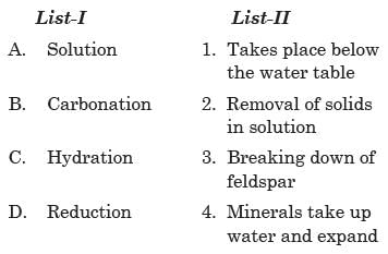
Match the following:

Select the correct answer using the code given below:

Detailed Solution for Test: Geography NCERT Based Test - 1 - Question 18
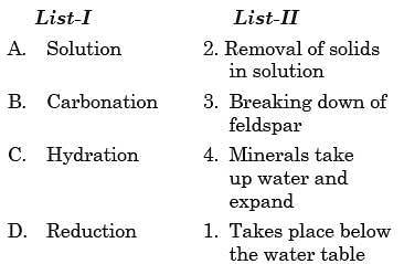
  • Option (d) is correct:

Supplementary notes:

Chemical Weathering Processes

  • A group of weathering processes viz; solution, carbonation, hydration, oxidation, and reduction act on the rocks to decompose, dissolve or reduce them to a fi ne clastic state through chemical reactions by oxygen, surface and/or soil water and other acids.

Solution

  • When something is dissolved in water or acids, the water or acid with dissolved contents is called solution. This process involves removal of solids in solution and depends upon solubility of a mineral in water or weak acids.

Carbonation

  • Carbonation is the reaction of carbonate and bicarbonate with minerals and is a common process helping the breaking down of feldspars and carbonate minerals. Carbon dioxide from the atmosphere and soil air is absorbed by water, to form carbonic acid that acts as a weak acid.

Hydration

  • Hydration is the chemical addition of water. Minerals take up water and expand; this expansion causes an increase in the volume of the material itself or rock.

Oxidation and Reduction

  • In weathering, oxidation means a combination of a mineral with oxygen to form oxides or hydroxides. Oxidation occurs where there is ready access to the atmosphere and oxygenated waters.
  • When oxidised minerals are placed in an environment where oxygen is absent, reduction takes place. Such conditions exist usually below the water table, in areas of stagnant water and waterlogged ground.
Test: Geography NCERT Based Test - 1 - Question 19

Which of the following evidences support the Continental Drift Theory?
1. Matching of Africa and South America continents.
2. Rocks of the same age across the oceans
3. Absences of source rock in the region of rich placer deposits
4. Distribution of fossils

Select the correct answer using the code given below:

Detailed Solution for Test: Geography NCERT Based Test - 1 - Question 19

All statements are correct

Supplementary notes:

Evidence in Support of the Continental Drift

  • The Matching of Continents (Jig-Saw-Fit)
    (i) The shorelines of Africa and South America facing each other have a remarkable and unmistakable match. 
    (ii) A map produced using a computer program to find the best fit of the Atlantic margin was presented by Bullard in 1964. The match was tried at 1,000- fathom line instead of the present shoreline.
  • Rocks of Same Age Across the Oceans
    (i) The radiometric dating methods developed in the recent period have facilitated correlating the rock formation from different continents across the vast ocean. 
    (ii) The belt of ancient rocks of 2,000 million years from the Brazil coast matches with those from western Africa.
    (iii) The earliest marine deposits along the coastline of South America and Africa are of the Jurassic age. This suggests that the ocean did not exist prior to that time.

Tillite

  • It is the sedimentary rock formed out of deposits of glaciers. The Gondwana system of sediments from India is known to have its counterparts in six different landmasses of the Southern Hemisphere.
  • At the base, the system has thick tillite indicating extensive and prolonged glaciation. Counterparts of this succession are found in Africa, Falkland Island, Madagascar, Antarctica and Australia besides India.
  • The overall resemblance of the Gondwana type sediments clearly demonstrates that these landmasses had remarkably similar histories.
  • The glacial tillite provides unambiguous evidence of paleoclimates and also of drifting of continents.

Placer Deposits

  • The occurrence of rich placer deposits of gold in the Ghana coast and the absolute absence of source rock in the region is an amazing fact.
  • The gold-bearing veins are in Brazil and it is obvious that the gold deposits of Ghana are derived from the Brazil plateau when the two continents lay side by side.

Distribution of Fossils

  • When identical species of plants and animals adapted to living on land or in freshwater are found on either side of the marine barriers, a problem arises regarding accounting for such distribution.
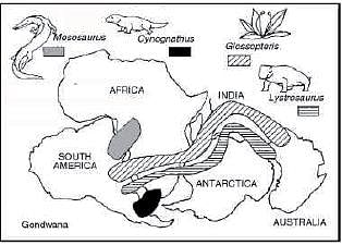
  • The observations that Lemurs occur in India, Madagascar, and Africa led some to consider a contiguous landmass “Lemuria” linking these three landmasses. Mesosaurus was a small reptile adapted to shallow brackish water.
  • The skeletons of these are found only in two localities: the Southern Cape province of South Africa and Iraver formations of Brazil.
  • The two localities presently are 4,800 km apart with an ocean in between them.
Test: Geography NCERT Based Test - 1 - Question 20

Arrange the following Stages of the evolution of the earth’s atmosphere in chronological order:
1. Process of photosynthesis
2. Loss of primordial atmosphere
3. Hot gases outpoured from the interior

Select the correct answer using the code given below:

Detailed Solution for Test: Geography NCERT Based Test - 1 - Question 20
  • Option (c) is correct: The correct chronology in the Stages in the Evolution of atmosphere is
    (i) Loss of the primordial atmosphere
    (ii) Hot gases outpoured from the interior
    (iii) Process of photosynthesis

Supplementary notes:

Evolution of the Atmosphere

There are three stages in the evolution of the present atmosphere:

  • The first stage is marked by the loss of the primordial atmosphere.
  • In the second stage, the hot interior of the earth contributed to the evolution of the atmosphere.
  • Finally, the composition of the atmosphere was modified by the living world through the process of photosynthesis.
Test: Geography NCERT Based Test - 1 - Question 21

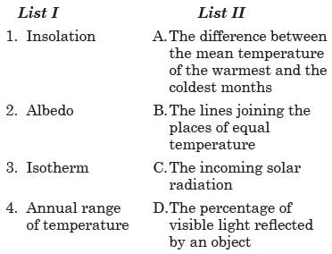
Match the following:

Select the correct answer using the code given below:

Detailed Solution for Test: Geography NCERT Based Test - 1 - Question 21

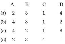
Option (a) is correct:

Supplementary notes:

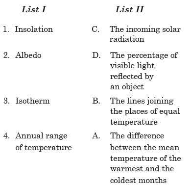
Insolation

  • The earth’s surface receives most of its energy in short wavelengths.
  • The energy received by the earth is known as incoming solar radiation which in short is termed as insolation.

Albedo

  • The percentage of visible light reflected by an object is called its albedo.

Isotherm

  • The temperature distribution is generally shown on the map with the help of isotherms.
  • The isotherms are lines joining places having an equal temperature.

Annual range

  • It is the difference between the mean temperature of the warmest and the coldest months.
Test: Geography NCERT Based Test - 1 - Question 22

The phenomenon of wearing down of relief variations of the surface of the earth through erosion is known as:

Detailed Solution for Test: Geography NCERT Based Test - 1 - Question 22
  • Option (a) is correct: The phenomenon of wearing down of relief variations of the surface of the earth through erosion is known as Gradation

Supplementary notes:

Geomorphic Processes

  • The differences in the internal forces operating from within the earth which built up the crust have been responsible for the variations in the outer surface of the crust.
  • The earth’s surface is being continuously subjected to external forces induced basically by energy (sunlight).
  • The external forces are known as exogenic forces and the internal forces are known as endogenic forces.
  • The actions of exogenic forces result in wearing down (degradation) of relief/ elevations and filling up (aggradation) of basins/depressions, on the earth’s surface.
  • The phenomenon of wearing down of relief variations of the surface of the earth through erosion is known as gradation.
  • The endogenic forces continuously elevate or build up parts of the earth’s surface and hence the exogenic processes fail to even out the relief variations of the surface of the earth.
  • In general terms, the endogenic forces are mainly land building forces and the exogenic processes are mainly land wearing forces. The surface of the earth is sensitive. Humans depend on it for their sustenance and have been using it extensively and intensively.
Test: Geography NCERT Based Test - 1 - Question 23

Which of the following states get rainfall from northeast monsoon?

Detailed Solution for Test: Geography NCERT Based Test - 1 - Question 23

Option (a) is correct: North-Eastern Monsoon causes rainfall in the coastal areas of Tamil Nadu at the beginning of winter.

Supplementary notes:

Rainfall in Winter Monsoon

  • Winter monsoons do not cause rainfall as they move from land to the sea. So, most parts of India do not have rainfall in the winter season. However, there are some exceptions to it:
    (i) In northwestern India, some weak temperate cyclones from the Mediterranean sea cause rainfall in Punjab, Haryana, Delhi, and western Uttar Pradesh. Although the amount is meager, it is highly beneficial for rabi crops. The precipitation is in the form of snowfall in the lower Himalayas. It is this snow that sustains the fl ow of water in the Himalayan rivers during the summer months. The precipitation goes on decreasing from west to east in the plains and from north to south in the mountains. The average winter rainfall in Delhi is around 53 mm. In Punjab and Bihar, rainfall remains between 25 mm and 18 mm respectively.
    (ii) Central parts of India and northern parts of the southern Peninsula also get winter rainfall occasionally.
    (iii) Arunachal Pradesh and Assam in the northeastern parts of India also have rains between 25 mm and 50 mm during these winter months.
    (iv) During October and November, northeast monsoon while crossing over the Bay of Bengal picks up moisture and causes torrential rainfall over the Tamil Nadu coast, southern Andhra Pradesh, southeast Karnataka, and southeast Kerala.
Test: Geography NCERT Based Test - 1 - Question 24

Radio waves transmitted from the Earth’s surface are reflected back by which layer of atmosphere?

Detailed Solution for Test: Geography NCERT Based Test - 1 - Question 24

Option (c) is correct: Radio waves transmitted from the Earth are reflected back to the Earth by the ionosphere.

Supplementary notes:

Ionosphere

  • The ionosphere is located between 80 and 400 km above the Mesopause.
  • It contains electrically charged particles known as ions, and hence, it is known as the ionosphere.
  • Radio waves transmitted from the earth are reflected back to the earth by this layer.
  • The temperature here starts increasing with height.
Test: Geography NCERT Based Test - 1 - Question 25

“This coast has got certain distinguishing features in the form of ‘Kayals’, which are used for fishing, inland navigation and also due to its special attraction for tourists. Every year the famous Nehru Trophy Vallamkali is held in Punnamada Kayal”.The Coast refer in the quotation is?

Detailed Solution for Test: Geography NCERT Based Test - 1 - Question 25
  • Option (c) is correct:  The Coast refer in the quotation is Malabar coast.

Supplementary notes:

Western Coastal Plains

  • The western coastal plains are an example of the submerged coastal plain. It is believed that the city of Dwaraka which was once a part of the Indian mainland situated along the west coast is submerged underwater.
  • Because of this submergence, it is a narrow belt and provides natural conditions for the development of ports and harbours. Kandla, Mazagaon, JLN port Navha Sheva, Marmagao, Mangalore, Cochin, etc. are some of the important natural ports located along the west coast.
  • Extending from the Gujarat coast in the north to the Kerala coast in the south, the west coast may be divided into following divisions – the Kachchh and Kathiawar coast in Gujarat, Konkan coast in Maharashtra, Goan coast and Malabar coast in Karnataka and Kerala respectively.
  • The western coastal plains are narrow in the middle and get broader towards north and south. The rivers flowing through this coastal plain do not form any delta.
  • The Malabar coast has got certain distinguishing features in the form of ‘Kayals’ (backwaters), which are used for fishing, inland navigation and also due to its special attraction for tourists. Every year the famous Nehru Trophy Vallamkali (boat race) is held in Punnamada Kayal in Kerala.
Information about Test: Geography NCERT Based Test - 1 Page
In this test you can find the Exam questions for Test: Geography NCERT Based Test - 1 solved & explained in the simplest way possible. Besides giving Questions and answers for Test: Geography NCERT Based Test - 1, EduRev gives you an ample number of Online tests for practice

Top Courses for UPSC

Download as PDF

Top Courses for UPSC