UPSC Exam  >  UPSC Tests  >  मैप-आधारित टेस्ट - 4 - UPSC MCQ

मैप-आधारित टेस्ट - 4 - UPSC MCQ


Test Description

10 Questions MCQ Test - मैप-आधारित टेस्ट - 4

मैप-आधारित टेस्ट - 4 for UPSC 2024 is part of UPSC preparation. The मैप-आधारित टेस्ट - 4 questions and answers have been prepared according to the UPSC exam syllabus.The मैप-आधारित टेस्ट - 4 MCQs are made for UPSC 2024 Exam. Find important definitions, questions, notes, meanings, examples, exercises, MCQs and online tests for मैप-आधारित टेस्ट - 4 below.
Solutions of मैप-आधारित टेस्ट - 4 questions in English are available as part of our course for UPSC & मैप-आधारित टेस्ट - 4 solutions in Hindi for UPSC course. Download more important topics, notes, lectures and mock test series for UPSC Exam by signing up for free. Attempt मैप-आधारित टेस्ट - 4 | 10 questions in 12 minutes | Mock test for UPSC preparation | Free important questions MCQ to study for UPSC Exam | Download free PDF with solutions
मैप-आधारित टेस्ट - 4 - Question 1

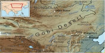
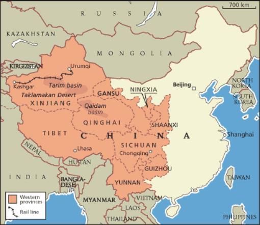
निम्नलिखित कथनों पर विचार करें

(i) रेगिस्तान तिब्बती पठार द्वारा गठित एक वर्षा छाया रेगिस्तान है।

(ii) रेगिस्तान एक ठंडा रेगिस्तान है जो दो देशों में फैला हुआ है।

रेगिस्तान की पहचान करें।

Consider the following statements

(i) The desert is a rain shadow desert formed by the Tibetan Plateau.

(ii) Desert is a cold desert which is spread over two countries.

Identify the desert.

Detailed Solution for मैप-आधारित टेस्ट - 4 - Question 1

मैप-आधारित टेस्ट - 4 - Question 2

सही संबंध चुनें:

(i) बगलिहार बांध-झेलम नदी

(ii) कृष्णगंगा बांध-चिनाब नदी

(iii) उरी बांध-झेलम नदी

Choose the correct relation:

(i) Baglihar Dam-Jhelum River

(ii) Krishnaganga Dam-Chenab River

(iii) Uri Dam-Jhelum River

Detailed Solution for मैप-आधारित टेस्ट - 4 - Question 2
  • बागलीहार बांध-चिनाब नदी

  • कृष्णगंगा बांध-झेलम नदी

  • उरी डैम-झेलम नदी


  • Baglihar Dam-Chenab River
  • Krishnaganga Dam-Jhelum River
  • Uri Dam-Jhelum River


1 Crore+ students have signed up on EduRev. Have you? Download the App
मैप-आधारित टेस्ट - 4 - Question 3

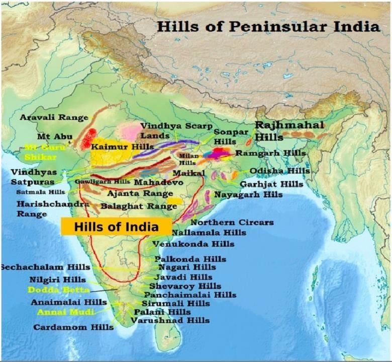
उत्तर से दक्षिण तक पहाड़ियों की व्यवस्था करें

(i) वेणुकोंडा हिल्स

(ii) वरुशनाद हिल्स

(iii) नागरी पहाड़ियाँ

(iv) सिरुमलाई हिल्स

Q. सही विकल्प चुनें

Detailed Solution for मैप-आधारित टेस्ट - 4 - Question 3

मैप-आधारित टेस्ट - 4 - Question 4

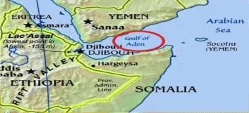
निम्नलिखित कथनों पर विचार करें:

(i) पहले इस खाड़ी को लोकप्रिय रूप से “बेरबेरा की खाड़ी ” कहा जाता था

(ii) यह जलमार्ग भूमध्य सागर और अरब सागर के बीच महत्वपूर्ण शिपिंग मार्ग है।

(iii) यह खाड़ी तीन देशों के साथ सीमाएं साझा करती है।

Q. सही विकल्प चुनें:

Consider the following statements:

(i) Earlier this bay was popularly known as "Gulf of Berbera"

(ii) This waterway is an important shipping route between the Mediterranean Sea and the Arabian Sea.

(iii) This gulf shares borders with three countries.

Q. Choose the correct option:

Detailed Solution for मैप-आधारित टेस्ट - 4 - Question 4

मैप-आधारित टेस्ट - 4 - Question 5

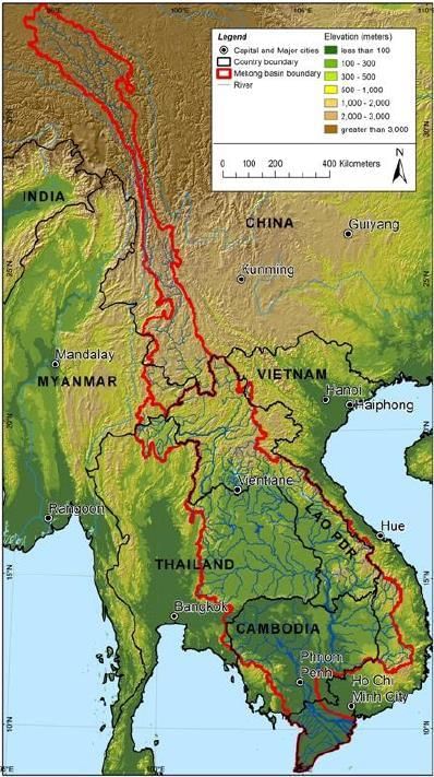
मेकांग नदी कितने देशों से होकर गुजरती है?

How many countries does the Mekong River pass through?

Detailed Solution for मैप-आधारित टेस्ट - 4 - Question 5

मैप-आधारित टेस्ट - 4 - Question 6

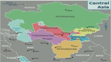
निम्नलिखित राजधानी शहरों को उत्तर से दक्षिण तक व्यवस्थित करें:

(i) अश्गाबात

(ii) बिश्केक

(iii) अस्ताना

(iv) ताशकंद

Arrange the following capital cities from north to south :

(i) Ashgabat

(ii) Bishkek

(iii) Astana

(iv) Tashkent

Detailed Solution for मैप-आधारित टेस्ट - 4 - Question 6

मैप-आधारित टेस्ट - 4 - Question 7

निम्नलिखित में से कौन सा बेसिन इंटरमाउंटेन बेसिन है?

Which of the following basins is an intermountain basin?

Detailed Solution for मैप-आधारित टेस्ट - 4 - Question 7
  • 27 झीलें हैं।
  • 1/4 नमक
  • 1 / 3rd रेगिस्तान


  • There are 27 lakes.
  • 1/4 salt
  • 1/3rd desert

मैप-आधारित टेस्ट - 4 - Question 8

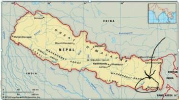
महाभारत श्रेणी के दक्षिण में कौन सी पहाड़ियाँ हैं?

Which hills are to the south of the Mahabharata range?

Detailed Solution for मैप-आधारित टेस्ट - 4 - Question 8

मैप-आधारित टेस्ट - 4 - Question 9

सही मिलान चुनें:

बाँध-नदियाँ

(i) गोविंद बल्लभ पंत सागर- रिहंद

(ii) हीराकुंड - महानदी

(iii) नागार्जुन सागर- कावेरी

Choose the correct match:

dams

(i) Govind Ballabh Pant Sagar- Rihand

(ii) Hirakund -Mahanadi

(iii) Nagarjuna Sagar- Kaveri

Detailed Solution for मैप-आधारित टेस्ट - 4 - Question 9
  • Govind Ballabh Pant Sagar- Rihand

  • Hirakund -Mahanadi

  • Nagariuna Sagar- Krishna


  • Govind Ballabh Pant Sagar - Rihand
  • Hirakud - Mahanadi
  • Nagriuna Sagar - Krishna
मैप-आधारित टेस्ट - 4 - Question 10

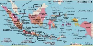
अगर मलक्का जलडमरूमध्य से यात्रा की जाए तो निम्न में से कौन सा एक पार आ सकता है:

Which one of the following can come across if traveling through the Straits of Malacca:

Detailed Solution for मैप-आधारित टेस्ट - 4 - Question 10

Information about मैप-आधारित टेस्ट - 4 Page
In this test you can find the Exam questions for मैप-आधारित टेस्ट - 4 solved & explained in the simplest way possible. Besides giving Questions and answers for मैप-आधारित टेस्ट - 4, EduRev gives you an ample number of Online tests for practice

Top Courses for UPSC

Download as PDF

Top Courses for UPSC