UPSC Exam  >  UPSC Tests  >  टेस्ट: भारत का भौतिक विज्ञान विभाग - UPSC MCQ

टेस्ट: भारत का भौतिक विज्ञान विभाग - UPSC MCQ


Test Description

15 Questions MCQ Test - टेस्ट: भारत का भौतिक विज्ञान विभाग

टेस्ट: भारत का भौतिक विज्ञान विभाग for UPSC 2024 is part of UPSC preparation. The टेस्ट: भारत का भौतिक विज्ञान विभाग questions and answers have been prepared according to the UPSC exam syllabus.The टेस्ट: भारत का भौतिक विज्ञान विभाग MCQs are made for UPSC 2024 Exam. Find important definitions, questions, notes, meanings, examples, exercises, MCQs and online tests for टेस्ट: भारत का भौतिक विज्ञान विभाग below.
Solutions of टेस्ट: भारत का भौतिक विज्ञान विभाग questions in English are available as part of our course for UPSC & टेस्ट: भारत का भौतिक विज्ञान विभाग solutions in Hindi for UPSC course. Download more important topics, notes, lectures and mock test series for UPSC Exam by signing up for free. Attempt टेस्ट: भारत का भौतिक विज्ञान विभाग | 15 questions in 20 minutes | Mock test for UPSC preparation | Free important questions MCQ to study for UPSC Exam | Download free PDF with solutions
टेस्ट: भारत का भौतिक विज्ञान विभाग - Question 1

हिमालय से संबंधित निम्नलिखित कथनों पर विचार करें:

(i) वे पुराने गुना पहाड़ हैं।

(ii) ये पश्चिम से पूर्व दिशा की ओर चलते हैं

ऊपर दिए गए कथनों में से कौन सा सही है / हैं?

With reference to the Himalayas, consider the following statements:

(i) They are old Guna mountains.

(ii) They move from west to east

Which of the above statements is/are correct?

Detailed Solution for टेस्ट: भारत का भौतिक विज्ञान विभाग - Question 1

कथन 1 गलत है।

कथन 2 सही है।


टेस्ट: भारत का भौतिक विज्ञान विभाग - Question 2

सिंधु नदी किस सीमा से निकलती है?

From which border does the Indus river originate?

Detailed Solution for टेस्ट: भारत का भौतिक विज्ञान विभाग - Question 2

सिंधु नदी से निकलती है उत्तरी ढलान के कैलाश रेंज ।

The Indus River originates on the northern slopes of the Kailash Range.

1 Crore+ students have signed up on EduRev. Have you? Download the App
टेस्ट: भारत का भौतिक विज्ञान विभाग - Question 3

निम्नलिखित पहाड़ियों पर विचार करें:

(i) गारो हिल्स।

(ii) जयंतिया पहाड़ियाँ।

(iii) खासी पहाड़ियाँ।

नीचे दिए गए विकल्प में से कौन पश्चिम से पूर्व की ओर ऊपर की पहाड़ियों की व्यवस्था के संबंध में सही है?

Consider the following hills:

(i) Garo Hills.

(ii) Jaintia Hills.

(iii) Khasi Hills.

Which of the following options is correct with respect to the arrangement of hills from west to east?

Detailed Solution for टेस्ट: भारत का भौतिक विज्ञान विभाग - Question 3
  • गारो हिल्स → खासी हिल्स → जयंतिया हिल्स

  • ये पश्चिम से पूर्व की ओर बांग्लादेश के साथ सीमा पर स्थित हैं।


टेस्ट: भारत का भौतिक विज्ञान विभाग - Question 4

निम्नलिखित कथनों पर विचार करें:

(i) नागा हिल्स की सब से ऊँची चोटी सारमाती है।

(ii) मिजो पहाड़ियों में नीला पहाड़ सबसे ऊँचा है

ऊपर दिए गए कथनों में से कौन सा सही है / हैं?

Consider the following statements:

(i) The highest peak of the Naga Hills is Saramati.

(ii) Nila Pahar is the highest among the Mizo hills

Which of the above statements is/are correct?

Detailed Solution for टेस्ट: भारत का भौतिक विज्ञान विभाग - Question 4

नागा हिल्स में सरमाटी (3,826 मीटर) और मिज़ो हिल्स में ब्लू माउंटेन (2,157 मीटर) अपनी-अपनी पहाड़ियों की सबसे ऊंची चोटियाँ हैं।

Sarmati (3,826 m) in Naga Hills and Blue Mountain (2,157 m) in Mizo Hills are the highest peaks of their respective hills.

टेस्ट: भारत का भौतिक विज्ञान विभाग - Question 5

हिमालय के बारे में, निम्नलिखित में से कौन सा कथन सत्य है?

(i) इनकी चौड़ाई कश्मीर में 400 किलोमीटर से लेकर अरुणाचल प्रदेश में 150 किलोमीटर तक है।

(ii) वे अल्पाइन पृथ्वी आंदोलन के तहत तृतीयक युग के दौरान आए हैं।

(iii) पश्चिमी अर्धांश की तुलना में पूर्वी अर्धांश में ऊँचाई भिन्नताएँ अधिक हैं।

नीचे दिए गए कोड का उपयोग करके सही उत्तर चुनें:

Which of the following statements are true about the Himalayas?

(i) Their width ranges from 400 km in Kashmir to 150 km in Arunachal Pradesh.

(ii) They have come under the alpine earth movement during the Tertiary era.

(iii) The altitude variations are greater in the eastern half than in the western half.

Select the correct answer using the codes given below :

Detailed Solution for टेस्ट: भारत का भौतिक विज्ञान विभाग - Question 5

कथन 1 सही है

  • हिमालय दुनिया के सबसे ऊबड़-खाबड़ पहाड़ी बाधाओं में से एक है। वे एक चाप बनाते हैं, जो लगभग 2,400 किलोमीटर की दूरी तय करता है, जो पश्चिम में जम्मू और कश्मीर से पूर्व में अरुणाचल प्रदेश तक निर्बाध रूप से फैलता है। इनकी चौड़ाई कश्मीर में 400 किलोमीटर से लेकर अरुणाचल प्रदेश में 150 किलोमीटर तक है।

कथन 2 सही है

  • वे दुनिया के सबसे नए गुना पहाड़ों में से एक हैं और वे अल्पाइन पृथ्वी आंदोलन के तहत तृतीयक युग के दौरान आए हैं।

कथन 3 सही है

  •  पूर्वी आधे भाग की तुलना में पूर्वी आधे हिस्से में ऊँचाई भिन्नताएँ अधिक हैं, यही कारण है कि माउंट एवरेस्ट जैसी ऊंची पर्वत चोटियाँ और कंचनजंगा पूर्वी हिमालय में मौजूद हैं।

statement 1 is correct

  • The Himalayas are one of the most rugged mountainous terrains in the world. They form an arc, covering a distance of about 2,400 km, which extends uninterruptedly from Jammu and Kashmir in the west to Arunachal Pradesh in the east. Their width ranges from 400 km in Kashmir to 150 km in Arunachal Pradesh.

statement 2 is correct

  • They are one of the world's newest fold mountains and they occurred during the Tertiary Age under the Alpine Earth Movement.

statement 3 is correct

  • Elevation variations are greater in the eastern half than in the eastern half, which is why high mountain peaks such as Mount Everest and Kangchenjunga are present in the eastern Himalayas.
टेस्ट: भारत का भौतिक विज्ञान विभाग - Question 6

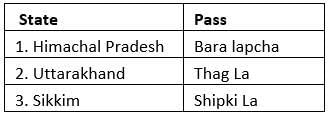
निम्नलिखित जोड़े पर विचार करें:

ऊपर दी गई कौन सी जोड़ी सही है?

Detailed Solution for टेस्ट: भारत का भौतिक विज्ञान विभाग - Question 6

जोड़ी 1

हिमाचल प्रदेश में सही शिपकी ला और बारा लापचा ला है।

Pair 2 is correct

Niti, Lipulekh and Thag La in Uttarakhand.

जोड़ी 3

सिक्किम में गलत जेलेप ला और नाथू ला है।

टेस्ट: भारत का भौतिक विज्ञान विभाग - Question 7

निम्न हिमालय के बारे में, निम्नलिखित में से कौन सा कथन सही है?

(i) ये रेंज मेटामॉर्फिक चट्टानों से बनी हैं।

(ii) शिमला, मसूरी, नैनीताल, रानीखेत इसमें खूबसूरत हिल स्टेशन हैं।

(iii) पीर पंजाल कम हिमालय की महत्वपूर्ण श्रेणी है।

ऊपर दिए गए कथनों में से कौन सा सही है / हैं?

Which of the following statements about the Lower Himalayas is correct?

(i) These ranges are made up of metamorphic rocks.

(ii) Shimla, Mussoorie, Nainital, Ranikhet are beautiful hill stations in it.

(iii) Pir Panjal is an important range of Lesser Himalayas.

Which of the above statements is/are correct?

Detailed Solution for टेस्ट: भारत का भौतिक विज्ञान विभाग - Question 7

कथन 1 सही है

ये श्रेणियाँ मेटामॉर्फिक चट्टानों से बनी हैं।

कथन 2 सही है:

इसमें प्रसिद्ध और सुंदर हिल स्टेशन हैं जिनमें शिमला, मसूरी, नैनीताल, रानीखेत आदि शामिल हैं।

कथन 3 सही है :

महत्वपूर्ण श्रेणियों में पीर पंजाल, धौलाधार और नाग टिब्बा शामिल हैं।

statement 1 is correct

These ranges are composed of metamorphic rocks.

Statement 2 is correct:

It has famous and beautiful hill stations which include Shimla, Mussoorie, Nainital, Ranikhet, etc.

Statement 3 is correct :

Important ranges include Pir Panjal, Dhauladhar, and Nag Tibba.

टेस्ट: भारत का भौतिक विज्ञान विभाग - Question 8

निम्नलिखित मार्ग पर विचार करें:

उच्च बर्फ से ढँकी चोटियों, गहरी घाटियों, इंटरलॉक्ड स्पर्स और हाई माउंटेन पासों द्वारा विशेषता। करेवा मिट्टी जो केसर और अन्य सूखे फलों की खेती के लिए प्रसिद्ध है, यहाँ पाई जाती है। इस क्षेत्र में प्रमुख रेंज में काराकोरम, लद्दाख, पीर पंजाल, ज़स्कर और ढोला धार हैं।

उपरोक्त मार्ग में निम्नलिखित में से किस क्षेत्र का वर्णन किया गया है?

Consider the following route:

Characterized by high snow-capped peaks, deep valleys, interlocked spurs and high mountain passes. Kareva soil which is famous for the cultivation of saffron and other dry fruits is found here. The major ranges in this region are Karakoram, Ladakh, Pir Panjal, Zaskar and Dhola Dhar.

Which of the following areas is described in the above passage?

Detailed Solution for टेस्ट: भारत का भौतिक विज्ञान विभाग - Question 8

कश्मीर / पंजाब / हिमाचल हिमालय

  • ये  जम्मू कश्मीर, लद्दाख, हिमाचल प्रदेश और पंजाब के कुछ हिस्सों में हैं। सिंधु और सतलुज नदी के बीच स्थित है

  • उच्च बर्फ से ढँकी चोटियों, गहरी घाटियों, इंटरलॉक्ड स्पर्स और हाई माउंटेन पासों द्वारा विशेषता। करेवा मिट्टी जो केसर और अन्य शुष्क फलों की खेती के लिए प्रसिद्ध है, यहाँ पाई जाती है।

  • महत्वपूर्ण श्रेणियां हैं काराकोरम, लद्दाख, पीर पंजाल, ज़ांस्कर और धौलाधार।

Kashmir / Punjab / Himachal Himalayas

These are in parts of Jammu Kashmir, Ladakh, Himachal Pradesh and Punjab. Situated between Indus and Sutlej river

Characterized by high snow-capped peaks, deep valleys, interlocked spurs and high mountain passes. Kareva soil which is famous for the cultivation of saffron and other dry fruits is found here.

The important ranges are the Karakoram, Ladakh, Pir Panjal, Zanskar and Dhauladhar.

टेस्ट: भारत का भौतिक विज्ञान विभाग - Question 9

निम्नलिखित में से किस क्षेत्र में पिंडारी, गंगोत्री और मिलम ग्लेशियर पाए जाते हैं?

In which of the following regions Pindari, Gangotri, and Milam glaciers are found?

Detailed Solution for टेस्ट: भारत का भौतिक विज्ञान विभाग - Question 9

कुमायूँ हिमालय

  • ये सतलुज और काली नदी के बीच स्थित हैं

  • यह सिंधु और गंगा नदी प्रणालियों द्वारा सूखा जाता है। यह चंडीगढ़-कालका डन और देहरादून जैसे 'डुन' संरचनाओं द्वारा प्रतिष्ठित है। वे भूटिया लोगों द्वारा बसे हुए हैं, जो 'बुग्यालों' में प्रवास करते हैं, जो गर्मियों के घास के मैदान हैं। 'फूलों की घाटी' यहाँ स्थित है।

  • महत्वपूर्ण ग्लेशियर पिंडारी, गंगोत्री और मिलम हैं।

Kumaun Himalaya

It is situated between Sutlej and Kali river.

It is drained by the Indus and Ganges river systems. It is distinguished by 'dun' structures like Chandigarh-Kalka Dun and Dehradun. They are inhabited by the Bhutia people, who migrate in the 'bugyalas', which are summer grasslands. The 'Valley of Flowers' is located here.

The important glaciers are Pindari, Gangotri and Milam.


टेस्ट: भारत का भौतिक विज्ञान विभाग - Question 10

निम्नलिखित में से किस क्षेत्र में माउंट। एवरेस्ट, कंचनजंगा, मकालू, धौलागिरी, पर्वत पाए जाते हैं?

In which of the following regions Mt. Everest, Kanchenjunga, Makalu, Dhaulagiri, mountains are found in?

Detailed Solution for टेस्ट: भारत का भौतिक विज्ञान विभाग - Question 10
  • मध्य / नेपाल हिमालय / दार्जिलिंग और सिक्किम हिमालय

  • नेपाल में ये लाई काली नदी से कोसी नदी (नेपाल हिमालय) तक और कोसी नदी के बीच तीस्ता नदी (दार्जिलिंग और सिक्किम हिमालय) तक फैली हुई हैं।

  • ये अपनी तेज-तर्रार नदियों जैसे A टीईईएसटीएए ’और पूरे वर्ष अच्छी बारिश और हल्की सर्दियां के कारण अपने चाय बागानों के लिए जाने जाते हैं। उन्हें ' DUAR ' फॉर्मेशन के लिए भी जाना जाता है ।

  • महत्वपूर्ण चोटियाँ माउंट एवरेस्ट, कंचनजंगा, मकालू, धौलागिरी, अन्नपूर्णा, मानसलू और गोसाईनाथ हैं।

Central / Nepal Himalaya / Darjeeling and Sikkim Himalaya

In Nepal, these extend from the Lai Kali River to the Kosi River (Nepal Himalayas) and between the Kosi River to the Teesta River (Darjeeling and Sikkim Himalayas).

They are known for their tea gardens due to their fast-flowing rivers like 'Teesta' and good rains and mild winters throughout the year. He is also known for the 'DUAR' formation

Important peaks are Mt. Everest, Kanchenjunga, Makalu, Dhaulagiri, Annapurna, Manaslu, and Gosainath..

टेस्ट: भारत का भौतिक विज्ञान विभाग - Question 11

निम्नलिखित में से किसे अक्सर बर्फ की नदी कहा जाता है?

Which of the following is often called the river of ice?

Detailed Solution for टेस्ट: भारत का भौतिक विज्ञान विभाग - Question 11

शब्द "ग्लेशियर" फ्रेंच शब्द ग्लेश (ग्लेह-एसएवाई) से आया है, जिसका अर्थ है बर्फ। ग्लेशियरों को अक्सर "बर्फ की नदियाँ" कहा जाता है।

The word "glacier" comes from the French word gleche (gleh-SAY), meaning snow. Glaciers are often called "rivers of ice".

टेस्ट: भारत का भौतिक विज्ञान विभाग - Question 12

निम्नलिखित जोड़े पर विचार करें:

ऊपर दी गई कौन सी जोड़ी गलत है?

Detailed Solution for टेस्ट: भारत का भौतिक विज्ञान विभाग - Question 12
कथन 1 सही है

हिमालय काराकोरम रेंज के महत्वपूर्ण ग्लेशियर: सियाचिन, फेडचेंको (यह ध्रुवीय क्षेत्रों के बाहर दुनिया का सबसे लंबा ग्लेशियर है), हिसार, बियाफो और बाल्टोरो।

Statement 2 is incorrect:

Pir Panjal Range: Sonapani, Bara Shighi, Rakhiot and Gangri.

Statement 3 is incorrect

Kumaon-Garhwal Range: Kafni Glacier, Kalabaland Glacier, Kedar Bamak Glacier, Meola Glacier, Namik Glacier, Panchchuli Glacier, Pindari Glacier, Ralam Glacier, Satopanth Glacier and Chorabari Glacier.

टेस्ट: भारत का भौतिक विज्ञान विभाग - Question 13

निम्नलिखित कथनों पर विचार करें:

(i) पश्चिमी हिमालय का विस्तार काली नदी के पश्चिम तक है जबकि पूर्वी हिमालय का विस्तार काली से ब्रह्मपुत्र नदी तक है।

(ii) पूर्वी हिमालय की तुलना में पश्चिमी हिमालय में जैव विविधता कम है।

(iii) पूर्वी हिमालय की तुलना में पश्चिमी हिमालय में ऊंचाई अधिक है।

उपरोक्त में से कौन सा कथन पूर्वी हिमालय की पश्चिमी हिमालय की तुलना के बारे में सही है / हैं?

Consider the following statements:

(i) The Western Himalayas extend to the west of the Kali River while the Eastern Himalayas extend from Kali to the Brahmaputra River.

(ii) Biodiversity is less in the Western Himalayas as compared to the Eastern Himalayas.

(iii) The Western Himalayas have higher elevation than the Eastern Himalayas.

Which of the above statement(s) is/are correct about the comparison of the Eastern Himalayas with the Western Himalayas?

Detailed Solution for टेस्ट: भारत का भौतिक विज्ञान विभाग - Question 13

सभी कथन सही हैं

  • पश्चिमी हिमालय और पूर्वी हिमालय के बीच तुलना:

  • विस्तार: पश्चिमी हिमालय का विस्तार काली नदी के पश्चिम तक है जबकि पूर्वी हिमालय का विस्तार काली से ब्रह्मपुत्र नदी तक है।

  • ऊंचाई: पश्चिमी हिमालय भागों में बढ़ता है जबकि पूर्वी हिमालय मैदानी इलाकों से अचानक बढ़ता है।

  • वनस्पति: पश्चिमी हिमालय शंकुधारी वन और अल्पाइन वनस्पति हैं।

  • जैव विविधता: पूर्वी हिमालय की तुलना में पश्चिमी हिमालय में जैव विविधता कम है।

  • वर्षा: पश्चिमी हिमालय सर्दियों में उत्तर-पश्चिमी मानसून से प्राप्त होता है; पूर्वी हिमालय ग्रीष्मकाल में दक्षिण-पूर्वी मानसून प्राप्त करता है।

  • स्नोलाइन: पूर्वी हिमालय में कम; पश्चिमी हिमालय में उच्च।

  • ऊंचाई: यह पूर्वी हिमालय की तुलना में पश्चिमी हिमालय में अधिक है।

all statements are correct

Comparison between Western Himalaya and Eastern Himalaya:

Expansion: The Western Himalayas extend to the west of the Kali River while the Eastern Himalayas extend from Kali to the Brahmaputra River.

Elevation: Grows in the western Himalayan parts while the eastern Himalaya rises abruptly from the plains.

Vegetation: The Western Himalayas are coniferous forests and alpine vegetation.

Biodiversity: The Western Himalayas have less biodiversity as compared to the Eastern Himalayas.

Precipitation: Western Himalaya receives winter from the north-west monsoon; The Eastern Himalayas receive the South-East monsoon in summers.

Snowline: Low in the Eastern Himalayas; High in the Western Himalayas.

Altitude: It is higher in the Western Himalayas than in the Eastern Himalayas.

टेस्ट: भारत का भौतिक विज्ञान विभाग - Question 14

निम्नलिखित कथनों पर विचार करें

(i) उत्तरी ढलान की तुलना में दक्षिणी ढलान में अधिक वर्षा होती है।

(ii) दक्षिणी ढलान मोटी वनस्पति से आच्छादित हैं जबकि उत्तरी ढलान आमतौर पर बंजर हैं।

उपरोक्त बयानों में से कौन सा सही है / उत्तरी ढलान की तुलना हिमालय की दक्षिणी ढलानों से की जाती है?

Consider the following statements

(i) The southern slope receives more rainfall than the northern slope.

(ii) The southern slopes are covered with thick vegetation while the northern slopes are generally barren.

Which of the above statements is/are correct as compared to the northern slopes with the southern slopes of the Himalayas?

Detailed Solution for टेस्ट: भारत का भौतिक विज्ञान विभाग - Question 14
  • हिमालय के उत्तरी और दक्षिणी ढलानों के बीच तुलना

  • वर्षा: दक्षिणी ढलान उत्तरी ढाल की तुलना में अधिक प्राप्त करते हैं क्योंकि यह बारिश छाया क्षेत्र में स्थित है।

  • वनस्पति: दक्षिणी ढलान मोटी वनस्पति से आच्छादित हैं जबकि उत्तरी ढलान आमतौर पर बंजर हैं। दक्षिण से उत्तर की ओर वर्षा की मात्रा कम हो जाती है

  • स्नोलाइन: धूप की लंबी अवधि के कारण, दक्षिणी ढलानों पर उत्तरी ढलानों की तुलना में कम बर्फ जमा होती है।

Comparison between the northern and southern slopes of the Himalayas

Rainfall: The southern slope receives more than the northern slope because it is located in the rain shadow region.

Vegetation: The southern slopes are covered with thick vegetation while the northern slopes are generally barren. The amount of precipitation decreases from south to north

Snowline: Due to the longer duration of sunshine, the southern slopes accumulate less snow than the northern slopes.

टेस्ट: भारत का भौतिक विज्ञान विभाग - Question 15

निम्नलिखित में से कौन सा मार्ग मुंबई को नासिक से जोड़ता है?

Which of the following route connects Mumbai with Nashik?

Information about टेस्ट: भारत का भौतिक विज्ञान विभाग Page
In this test you can find the Exam questions for टेस्ट: भारत का भौतिक विज्ञान विभाग solved & explained in the simplest way possible. Besides giving Questions and answers for टेस्ट: भारत का भौतिक विज्ञान विभाग, EduRev gives you an ample number of Online tests for practice

Top Courses for UPSC

Download as PDF

Top Courses for UPSC