UPSC Exam  >  UPSC Tests  >  टेस्ट: इंडियन ड्रेनेज सिस्टम - UPSC MCQ

टेस्ट: इंडियन ड्रेनेज सिस्टम - UPSC MCQ


Test Description

29 Questions MCQ Test - टेस्ट: इंडियन ड्रेनेज सिस्टम

टेस्ट: इंडियन ड्रेनेज सिस्टम for UPSC 2024 is part of UPSC preparation. The टेस्ट: इंडियन ड्रेनेज सिस्टम questions and answers have been prepared according to the UPSC exam syllabus.The टेस्ट: इंडियन ड्रेनेज सिस्टम MCQs are made for UPSC 2024 Exam. Find important definitions, questions, notes, meanings, examples, exercises, MCQs and online tests for टेस्ट: इंडियन ड्रेनेज सिस्टम below.
Solutions of टेस्ट: इंडियन ड्रेनेज सिस्टम questions in English are available as part of our course for UPSC & टेस्ट: इंडियन ड्रेनेज सिस्टम solutions in Hindi for UPSC course. Download more important topics, notes, lectures and mock test series for UPSC Exam by signing up for free. Attempt टेस्ट: इंडियन ड्रेनेज सिस्टम | 29 questions in 35 minutes | Mock test for UPSC preparation | Free important questions MCQ to study for UPSC Exam | Download free PDF with solutions
टेस्ट: इंडियन ड्रेनेज सिस्टम - Question 1

निम्नलिखित में से कौन सी नदी 'दरार' घाटी से होकर बहती है?

Which of the following river flows through the 'Darar' valley?

Detailed Solution for टेस्ट: इंडियन ड्रेनेज सिस्टम - Question 1

नर्मदा नदी एक दरार घाटी से होकर बहती है।

टेस्ट: इंडियन ड्रेनेज सिस्टम - Question 2

निम्नलिखित में से क्या भारत की पश्चिम बहने वाली नदी है?

1. महानदी

2. कृष्ण

3. नर्मदा

4. कावेरी

सही उत्तर चुनें

Which of the following is the west-flowing river of India?

1. Mahanadi

2. Krishna

3. Narmada

4. Kaveri

Select the correct answer 

Detailed Solution for टेस्ट: इंडियन ड्रेनेज सिस्टम - Question 2

नर्मदा भारत की सबसे प्रसिद्ध नदियों में से एक है। यह दक्षिण भारत और उत्तर भारत के बीच पारंपरिक सीमा बनाता है।

गुजरात में भरूच शहर से 18.6 मील या 30 किलोमीटर पश्चिम में खंभात (कैम्बे) की खाड़ी से अरब सागर में बहने से पहले नदी 1,312 किमी (815.2 मील) की अवधि के लिए पश्चिम में चलती है।

Narmada is one of the most famous rivers of India. It forms the traditional border between South India and North India.

The river runs west for a period of 1,312 km (815.2 mi) before flowing into the Arabian Sea from the Gulf of Khambhat (Cambay), 18.6 mi or 30 km west of Bharuch city in Gujarat.

1 Crore+ students have signed up on EduRev. Have you? Download the App
टेस्ट: इंडियन ड्रेनेज सिस्टम - Question 3

निम्नलिखित में से कौन सी नदी दक्षिण से उत्तर की ओर बहती है?

Which of the following river flows from south to north?

Detailed Solution for टेस्ट: इंडियन ड्रेनेज सिस्टम - Question 3

नर्मदा एकमात्र नदी है जो दिए गए विकल्पों में दक्षिण से उत्तर की ओर बहती है।

Narmada is the only river which flows from South to North in the given options.

टेस्ट: इंडियन ड्रेनेज सिस्टम - Question 4

भारत में निम्नलिखित में से किस नदी को राष्ट्रीय नदी घोषित किया गया है?

Which of the following river has been declared as the National River in India?

Detailed Solution for टेस्ट: इंडियन ड्रेनेज सिस्टम - Question 4

गंगा भारत और बांग्लादेश की एक सीमा-पार नदी है। 2,525 किलोमीटर (1,569 मील) नदी भारतीय राज्य उत्तराखंड में पश्चिमी हिमालय में बहती है और दक्षिण और पूर्व में उत्तर भारत के गंगा के मैदान से होकर बांग्लादेश में बहती है, जहां यह बंगाल की खाड़ी में खाली हो जाती है। यह दुनिया की तीसरी सबसे बड़ी नदी है।

The Ganges is a cross-border river between India and Bangladesh. The 2,525-kilometre (1,569 mi) river flows in the western Himalayas in the Indian state of Uttarakhand and flows south and east through the Gangetic Plain of North India into Bangladesh, where it empties into the Bay of Bengal. It is the third-largest river in the world.

टेस्ट: इंडियन ड्रेनेज सिस्टम - Question 5

निम्नलिखित में से कौन सी नदी यमुना की सहायक नदी नहीं है?

Which of the following river is not a tributary of Yamuna?

टेस्ट: इंडियन ड्रेनेज सिस्टम - Question 6

भारत की निम्नलिखित नदियों में से कौन सी नदी डेल्टा नहीं बनाती है?
Which one of the following rivers of India does not form a delta?

Detailed Solution for टेस्ट: इंडियन ड्रेनेज सिस्टम - Question 6

नर्मदा, मध्य भारत में एक नदी है और भारतीय उपमहाद्वीप में पांचवीं सबसे लंबी नदी है। यह तीसरी सबसे लंबी नदी है जो पूरी तरह से गोदावरी और कृष्णा के बाद भारत के भीतर बहती है।

The Narmada is a river in central India and the fifth-longest river in the Indian subcontinent. It is the third longest river that flows entirely within India after Godavari and Krishna.

टेस्ट: इंडियन ड्रेनेज सिस्टम - Question 7

भारतीय रेगिस्तान की एक महत्वपूर्ण नदी है?

Which is an important river of Indian desert?

Detailed Solution for टेस्ट: इंडियन ड्रेनेज सिस्टम - Question 7

लूणी पश्चिमी राजस्थान राज्य, भारत की एक नदी है। यह अजमेर के पास अरावली रेंज की पुष्कर घाटी में उत्पन्न होती है और 495 किमी की दूरी तय करने के बाद गुजरात में कच्छ के रण की दलदली भूमि में समाप्त होती है।

Luni is a river in western Rajasthan state, India. It originates in the Pushkar valley of the Aravalli range near Ajmer and after covering a distance of 495 km ends in the marshy lands of the Rann of Kutch in Gujarat.

टेस्ट: इंडियन ड्रेनेज सिस्टम - Question 8

वर्तमान में कौन सी नदी अस्तित्व में नहीं है?

Which river does not exist at present?

Detailed Solution for टेस्ट: इंडियन ड्रेनेज सिस्टम - Question 8

सरस्वती नदी एक नदी को संदर्भित करती है जो भागीरथी का एक वितरण था और अब वहां नहीं है लेकिन 16 वीं शताब्दी ईस्वी के आसपास तक सक्रिय था।

सरस्वती के पाठ्यक्रम और स्थिति ने बंगाल में नदी बंदरगाह शहरों के विकास और गिरावट में महत्वपूर्ण भूमिका निभाई है। प्रारंभ में, प्रमुख बंदरगाह शहर ताम्रलिप्टा था, इसके पतन के बाद सप्तग्राम गुलाब और गिरावट आई, और अंत में, कोलकाता आया।

The Saraswati river refers to a river that was a distributary of the Bhagirathi and is no longer there but was active until around the 16th century AD.

The course and position of the Sarasvati played an important role in the growth and decline of river port cities in Bengal. Initially, the major port city was Tamralipta, after its fall the Saptagram rose and declined, and finally, came Kolkata.

टेस्ट: इंडियन ड्रेनेज सिस्टम - Question 9

भारत की कौन-सी प्रमुख नदी डेल्टा नहीं बनाती है?

Which major river of India does not form a delta?

Detailed Solution for टेस्ट: इंडियन ड्रेनेज सिस्टम - Question 9

नदी द्वारा डेल्टा निर्माण की शर्तें:

नदी के निचले हिस्से में एक कोमल ढाल होना चाहिए नदी को अपने साथ बड़ी मात्रा में तलछट ले जानी चाहिए

तटीय मैदान या क्षेत्र जहां नदी का मुंह चौड़ा होना चाहिए

हालांकि नर्मदा पश्चिमी घाट से बहुत दूर है और अरब सागर में निकलती है, लेकिन नदी एक बहाव घाटी से होकर एक तेज ढाल पर बहती है जिससे इसकी गति बढ़ जाती है। इसके अलावा, नर्मदा के डेल्टा गठन के लिए पश्चिमी तटीय मैदान कम से कम व्यापक हैं।

Terms of Delta Formation by River:

The lower part of the river should have a gentle slope. The river should carry a large amount of sediment with it.

Coastal plain or area where the mouth of the river should be wide

Although the Narmada is far away from the Western Ghats and drains into the Arabian Sea, the river flows through a rift valley on a steep slope which increases its speed. Furthermore, the western coastal plains are the least extensive for the Narmada delta formation.

टेस्ट: इंडियन ड्रेनेज सिस्टम - Question 10

गंगा नदियों के संगम का परिणाम है-

The result of the confluence of the Ganges rivers is-

Detailed Solution for टेस्ट: इंडियन ड्रेनेज सिस्टम - Question 10

भागीरथी और अलकनंदा नदियाँ देवप्रयाग में मिलती हैं और नीचे की ओर गंगा के रूप में प्रवाहित होती हैं।

The Bhagirathi and Alaknanda rivers meet at Devprayag and flow downstream as the Ganges.

टेस्ट: इंडियन ड्रेनेज सिस्टम - Question 11

सूची- II के साथ सूची- I का मिलान करें और का उपयोग करके सही उत्तर चुनें

नीचे दिए गए कोड:
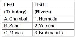
ऊपर दी गई कौन सी जोड़ी सही ढंग से मेल खाती है / हैं?

Detailed Solution for टेस्ट: इंडियन ड्रेनेज सिस्टम - Question 11

मानस नदी असम से बहने वाली ब्रह्मपुत्र नदी की एक प्रमुख सहायक नदी है। यह हिंदू पौराणिक कथाओं में नाग देवता "देवी मानसा" के नाम पर है।

मानस नदी दक्षिणी भूटान और भारत के बीच हिमालय की तलहटी में एक सीमा-पार नदी है।

टेस्ट: इंडियन ड्रेनेज सिस्टम - Question 12

निम्नलिखित में से कौन उत्तर से दक्षिण तक की नदियों का सही अनुक्रम है?

Which of the following is the correct sequence of rivers from north to south?

टेस्ट: इंडियन ड्रेनेज सिस्टम - Question 13

सूची- II के साथ सूची- I का मिलान करें और इनमें से सही उत्तर चुनें

नीचे दिए गए कोड:
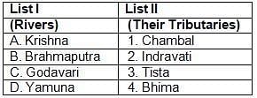
Detailed Solution for टेस्ट: इंडियन ड्रेनेज सिस्टम - Question 13
-
टेस्ट: इंडियन ड्रेनेज सिस्टम - Question 14

जलाशय जीबी पंत सागर किस नदी पर स्थित है?

Reservoir GB Pant Sagar is situated on which river?

Detailed Solution for टेस्ट: इंडियन ड्रेनेज सिस्टम - Question 14

गोविंद बल्लभ पंत सागर रिहंद नदी पर है

Govind Ballabh Pant Sagar is on the Rihand River

टेस्ट: इंडियन ड्रेनेज सिस्टम - Question 15

निम्नलिखित में से कौन सी नदी अरब सागर में बहती है?

Which of the following rivers flows into the Arabian Sea?

Detailed Solution for टेस्ट: इंडियन ड्रेनेज सिस्टम - Question 15

नर्मदा खंभात (अरब सागर) की खाड़ी में बहती है।

Narmada flows into the Gulf of Khambhat (Arabian Sea).

टेस्ट: इंडियन ड्रेनेज सिस्टम - Question 16

डेल्टा पूर्वी बहने वाली नदी प्रणालियों के लिए भारत में आम हैं, जबकि वे पश्चिम तट पर लगभग अनुपस्थित हैं क्योंकि पश्चिम-बहने वाली नदी

Deltas are common in India for east-flowing river systems, while they are almost absent on the west coast as west-flowing river systems.

Detailed Solution for टेस्ट: इंडियन ड्रेनेज सिस्टम - Question 16

पश्चिमी बहने वाली अधिकांश नदियाँ कठोर चट्टानों के माध्यम से पश्चिमी तट की ओर कम दूरी की यात्रा करती हैं और एक उच्च ढाल पर, वे बहती हुई बड़ी मात्रा में इकट्ठा नहीं हो पाती हैं और पूर्व की बहती नदियों की तुलना में बहुत तेज़ गति से बहती हैं।

पूर्वी नदियाँ टूटी पहाड़ियों और पर्वत श्रृंखलाओं से होकर बहती हैं। इसलिए, वे चौड़ा हो गए और समुद्र में प्रवेश करने से पहले कम वेग के साथ बह गए। इसलिए, वे समुद्र में प्रवेश करने से पहले तलछट और गाद जमा करते हैं और डेल्टा बना सकते हैं।

Most west-flowing rivers travel a short distance to the west coast through hard rocks and at a higher slope, they do not collect as much as they flow and flow much faster than east-flowing rivers. Huh.

Eastern rivers flow through broken hills and mountain ranges. Therefore, they widened and drifted away with less velocity before entering the ocean. Therefore, they deposit sediment and silt before entering the ocean and can form deltas.

टेस्ट: इंडियन ड्रेनेज सिस्टम - Question 17

प्रायद्वीप भारत की निम्नलिखित तीन नदियों में से कौन सी अमरकंटक क्षेत्र उनके स्रोत के रूप में है?

Which of the following three rivers of peninsular India have Amarkantak region as their source?

Detailed Solution for टेस्ट: इंडियन ड्रेनेज सिस्टम - Question 17

सोन, महानदी और नर्मदा नदियाँ अमरकंटक क्षेत्र से निकलती हैं।

The Son, Mahanadi and Narmada rivers originate from the Amarkantak region.

टेस्ट: इंडियन ड्रेनेज सिस्टम - Question 18

उत्तर से दक्षिण तक सिंधु नदी की निम्न सहायक नदियों की व्यवस्था करें:

1. चिनाब

2. झेलम

3. रवि

4. सतलज

नीचे दिए गए कोड का उपयोग करके सही उत्तर चुनें:

Arrange the following tributaries of the Indus river from north to south:

1. Chenab

2. Jhelum

3. Sun

4. Sutlej

Select the correct answer using the codes given below :

टेस्ट: इंडियन ड्रेनेज सिस्टम - Question 19

नदी और उसकी सहायक नदी के निम्नलिखित में से कौन सा युग्म सही रूप से मेल नहीं खाता है?

Which of the following pair of river and its tributary is not correctly matched?

Detailed Solution for टेस्ट: इंडियन ड्रेनेज सिस्टम - Question 19

अमरावती नदी कावेरी नदी की सबसे लंबी सहायक नदी है।

The Amaravati River is the longest tributary of the Kaveri River.

टेस्ट: इंडियन ड्रेनेज सिस्टम - Question 20

अमरकंटक पहाड़ियाँ निम्न में से किस नदी का स्रोत है?

1. नर्मदा

2. महानदी

3. बने

4. बेटा

नीचे दिए गए कोड का उपयोग करके सही उत्तर चुनें:

Amarkantak hills are the source of which of the following rivers?

1. Narmada

2. Mahanadi

3. Became

4. Son

Select the correct answer using the codes given below :

Detailed Solution for टेस्ट: इंडियन ड्रेनेज सिस्टम - Question 20

नर्मदा नदी माईकल रेंज के अमरकंटक पहाड़ी से निकलती है। पराक्रमी नर्मदा नदी के साथ-साथ सोन, महानदी, और अरनदोह जो गोदावरी की एक प्रमुख सहायक नदी है जो अमरकंटक पठार में उत्पन्न होती है।

सोन नदी गंगा की दक्षिणी सहायक नदियों में सबसे बड़ी है जो मध्य प्रदेश में अमरकंटक के पास नर्मदा नदी के स्रोत के पास से निकलती है।

The Narmada river originates from the Amarkantak hills of the Maikal range. Along with the mighty Narmada River, the Son, Mahanadi, and Arandoh which are a major tributary of the Godavari originate in the Amarkantak plateau.

Son River is the largest of the southern tributaries of the Ganges which originates near the source of Narmada River near Amarkantak in Madhya Pradesh.

टेस्ट: इंडियन ड्रेनेज सिस्टम - Question 21

निम्नलिखित में से किस नदी का सबसे बड़ा जलग्रहण क्षेत्र है?

Which of the following river has the largest catchment area?

Detailed Solution for टेस्ट: इंडियन ड्रेनेज सिस्टम - Question 21

गोदावरी नदी महाराष्ट्र के नासिक जिले से निकलती है। इसकी लंबाई 1465 किमी है और इसके बाद, कृष्णा, महानदी, नर्मदा और कावेरी प्रायद्वीपीय भारत की सबसे बड़ी नदियाँ हैं।

The Godavari River originates in the Nashik district of Maharashtra. Its length is 1465 km and after that, Krishna, Mahanadi, Narmada and Kaveri are the largest rivers of peninsular India.

टेस्ट: इंडियन ड्रेनेज सिस्टम - Question 22

भारत में निम्नलिखित में से किस झरने में सबसे अधिक ऊँचाई है?

Which of the following waterfalls in India has the highest height?

Detailed Solution for टेस्ट: इंडियन ड्रेनेज सिस्टम - Question 22

भारत में कुंचिकल झरनों की ऊंचाई सबसे अधिक है। इसकी ऊंचाई लगभग 455 मीटर है।

Kunchikal Falls has the highest height in India. Its height is about 455 meters.

टेस्ट: इंडियन ड्रेनेज सिस्टम - Question 23

इनमें से कौन सी पश्चिम-बहने वाली नदियाँ दो पर्वत श्रेणियों के बीच बहती हैं?

Which of these west-flowing rivers flow between two mountain ranges?

Detailed Solution for टेस्ट: इंडियन ड्रेनेज सिस्टम - Question 23

यह प्रायद्वीपीय भारत में केवल तीन प्रमुख नदियों में से एक है जो ताप्ती नदी और माही नदी के साथ पूर्व से पश्चिम (सबसे लंबे समय तक बहने वाली नदी) तक चलती है। यह भारत की उन नदियों में से एक है जो सतपुड़ा और विंध्य पर्वतमाला के बीच पश्चिम में बहती हुई एक घाटी में बहती है।

It is one of only three major rivers in peninsular India that runs from east to west (the longest flowing river) along with the Tapti River and the Mahi River. It is one of the rivers of India that flows in a valley flowing west between the Satpura and Vindhya ranges.

टेस्ट: इंडियन ड्रेनेज सिस्टम - Question 24

गंडक नदी निम्नलिखित नदी प्रणालियों में से एक से जुड़ी है-

River Gandak is associated with one of the following river systems-

Detailed Solution for टेस्ट: इंडियन ड्रेनेज सिस्टम - Question 24

गंडक नदी, मध्य नेपाल और उत्तरी भारत में नदी भारत में गंगा की एक बाएं किनारे की सहायक नदी है।

The Gandak River, a river in central Nepal and northern India, is a left bank tributary of the Ganges in India.

टेस्ट: इंडियन ड्रेनेज सिस्टम - Question 25

निम्नलिखित में से कौन सी अलकनंदा नदी की एक सहायक नदी नहीं है?

Which of the following is not a tributary of river Alaknanda?

Detailed Solution for टेस्ट: इंडियन ड्रेनेज सिस्टम - Question 25

भिलंगना अलकनंदा की एक सहायक नदी नहीं है। भिलंगना नदी भारत के उत्तराखंड में एक हिमालयी नदी है, जो भागीरथी नदी की एक प्रमुख सहायक नदी है।

Bhilangana is not a tributary of the Alaknanda. The Bhilangana River is a Himalayan river in Uttarakhand, India, a major tributary of the Bhagirathi River.

टेस्ट: इंडियन ड्रेनेज सिस्टम - Question 26

निम्नलिखित में से कौन सा झरना - नदी ठीक से मेल नहीं खाता है?

Detailed Solution for टेस्ट: इंडियन ड्रेनेज सिस्टम - Question 26

लोध प्रपात लातेहार जिले में एक मध्य जंगल में एक झरना है। यह बुरहा नदी पर स्थित है।

Lodh Falls is a waterfall in a central forest in the Latehar district. It is situated on the Burha river.

टेस्ट: इंडियन ड्रेनेज सिस्टम - Question 27

सूची-I (नदी) के साथ सूची-I (टाउन) का मिलान करें और कोडों का उपयोग करके सही उत्तर चुनें

Detailed Solution for टेस्ट: इंडियन ड्रेनेज सिस्टम - Question 27

नांदेड़ शहर गोदावरी नदी के तट पर स्थित है।

नेल्लोर शहर पेननेर नदी के किनारे स्थित है।

होस्पेट शहर तुंगभद्रा नदी के तट पर स्थित है।

हैदराबाद शहर मुसी नदी के तट पर स्थित है।

टेस्ट: इंडियन ड्रेनेज सिस्टम - Question 28

राजरप्पा किन नदियों के संगम पर स्थित है?

Rajrappa is situated at the confluence of which rivers?

Detailed Solution for टेस्ट: इंडियन ड्रेनेज सिस्टम - Question 28

राजरप्पा झारखंड के रामगढ़ में एक झरना और एक तीर्थस्थल है। यह दामोदर - बेहरा नदियों के संगम पर स्थित है।

Rajrappa is a waterfall and a pilgrimage center in Ramgarh, Jharkhand. It is situated at the confluence of the Damodar - Behera rivers.

टेस्ट: इंडियन ड्रेनेज सिस्टम - Question 29

ब्रह्मपुत्र नदी की निम्न सहायक नदियों पर विचार करें:

1. लोहित

2. तिस्ता

3. सुबनसिरी

4. संकोश

उपरोक्त नदियों को पश्चिम से पूर्व की ओर व्यवस्थित करें:

Consider the following tributaries of river Brahmaputra:

1. Lohit

2. Teesta

3. Subansiri

4. Sankosh

Arrange the above rivers from west to east :

Information about टेस्ट: इंडियन ड्रेनेज सिस्टम Page
In this test you can find the Exam questions for टेस्ट: इंडियन ड्रेनेज सिस्टम solved & explained in the simplest way possible. Besides giving Questions and answers for टेस्ट: इंडियन ड्रेनेज सिस्टम, EduRev gives you an ample number of Online tests for practice

Top Courses for UPSC

Download as PDF

Top Courses for UPSC