Test: Climate- Graph & Case Based Type Questions - Humanities/Arts MCQ
15 Questions MCQ Test - Test: Climate- Graph & Case Based Type Questions
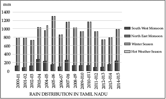
Direction: Study the given graph of annual rain distribution in Tamil Nadu (2017) carefully and answer any three of the questions that follow :

Q. The rainfall in the given graph is measured in:

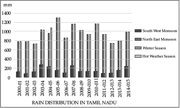
Direction: Study the given graph of annual rain distribution in Tamil Nadu (2017) carefully and answer any three of the questions that follow :

Q. Which year received 800 mm of rainfall from both Southwest and Northeast Monsoons?

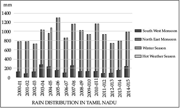
Direction: Study the given graph of annual rain distribution in Tamil Nadu (2017) carefully and answer any three of the questions that follow :

Q. Which year received the maximum rain from North East Monsoon?

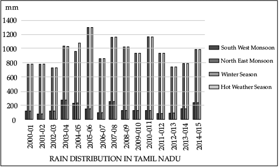
Direction: Study the given graph of annual rain distribution in Tamil Nadu (2017) carefully and answer any three of the questions that follow :

Q. Which year received the minimum rain from the North East Monsoon?
Direction: Read the case study given below and answer any three of the questions that follow.
The temperature of the world is significantly increasing. Carbon dioxide produced by human activities is a major source of concern. This gas, released to the atmosphere in large quantities by burning of fossil fuel, is increasing gradually. Other gases like methane, chlorofluorocarbons, and nitrous oxide which are present in much smaller concentrations in the atmosphere, together with carbon dioxide are known as greenhouse gases. These gases are better absorbers of long wave radiations than carbon dioxide, and so, are more effective at enhancing the greenhouse effect. These gases have been contributing to global warming. It is said that due to global warming the polar ice caps and mountain glaciers would melt and the amount of water in the oceans would increase. The mean annual surface temperature of the earth in the past 150 years has increased. It is projected that by the year 2,100, global temperature will increase by about 2°C. This rise in temperature will cause many other changes: one of these is arise in sea level, as a result of melting of glaciers and sea-ice due to warming. According to the current prediction, on an average, the sea level will rise 48 cm by the end of twenty first century. This would increase the incidence of annual flooding. Climatic change would promote insect-borne diseases like malaria, and lead to shift in climatic boundaries, making some regions wetter and others drier. Agricultural pattern would shift and human population as well as the ecosystem would experience change.
Q. Methane, chlorofluorocarbons and nitrous oxide along with carbon dioxide is known as:
Direction: Read the case study given below and answer any three of the questions that follow.
The temperature of the world is significantly increasing. Carbon dioxide produced by human activities is a major source of concern. This gas, released to the atmosphere in large quantities by burning of fossil fuel, is increasing gradually. Other gases like methane, chlorofluorocarbons, and nitrous oxide which are present in much smaller concentrations in the atmosphere, together with carbon dioxide are known as greenhouse gases. These gases are better absorbers of long wave radiations than carbon dioxide, and so, are more effective at enhancing the greenhouse effect. These gases have been contributing to global warming. It is said that due to global warming the polar ice caps and mountain glaciers would melt and the amount of water in the oceans would increase. The mean annual surface temperature of the earth in the past 150 years has increased. It is projected that by the year 2,100, global temperature will increase by about 2°C. This rise in temperature will cause many other changes: one of these is arise in sea level, as a result of melting of glaciers and sea-ice due to warming. According to the current prediction, on an average, the sea level will rise 48 cm by the end of twenty first century. This would increase the incidence of annual flooding. Climatic change would promote insect-borne diseases like malaria, and lead to shift in climatic boundaries, making some regions wetter and others drier. Agricultural pattern would shift and human population as well as the ecosystem would experience change.
Q. What would lead to shifts in agricultural patterns and the ecosystem?
Direction: Read the case study given below and answer any three of the questions that follow.
The temperature of the world is significantly increasing. Carbon dioxide produced by human activities is a major source of concern. This gas, released to the atmosphere in large quantities by burning of fossil fuel, is increasing gradually. Other gases like methane, chlorofluorocarbons, and nitrous oxide which are present in much smaller concentrations in the atmosphere, together with carbon dioxide are known as greenhouse gases. These gases are better absorbers of long wave radiations than carbon dioxide, and so, are more effective at enhancing the greenhouse effect. These gases have been contributing to global warming. It is said that due to global warming the polar ice caps and mountain glaciers would melt and the amount of water in the oceans would increase. The mean annual surface temperature of the earth in the past 150 years has increased. It is projected that by the year 2,100, global temperature will increase by about 2°C. This rise in temperature will cause many other changes: one of these is arise in sea level, as a result of melting of glaciers and sea-ice due to warming. According to the current prediction, on an average, the sea level will rise 48 cm by the end of twenty first century. This would increase the incidence of annual flooding. Climatic change would promote insect-borne diseases like malaria, and lead to shift in climatic boundaries, making some regions wetter and others drier. Agricultural pattern would shift and human population as well as the ecosystem would experience change.
Q. Which gas is a better absorber of long wave radiations?
Direction: Read the case study given below and answer any three of the questions that follow.
The temperature of the world is significantly increasing. Carbon dioxide produced by human activities is a major source of concern. This gas, released to the atmosphere in large quantities by burning of fossil fuel, is increasing gradually. Other gases like methane, chlorofluorocarbons, and nitrous oxide which are present in much smaller concentrations in the atmosphere, together with carbon dioxide are known as greenhouse gases. These gases are better absorbers of long wave radiations than carbon dioxide, and so, are more effective at enhancing the greenhouse effect. These gases have been contributing to global warming. It is said that due to global warming the polar ice caps and mountain glaciers would melt and the amount of water in the oceans would increase. The mean annual surface temperature of the earth in the past 150 years has increased. It is projected that by the year 2,100, global temperature will increase by about 2°C. This rise in temperature will cause many other changes: one of these is arise in sea level, as a result of melting of glaciers and sea-ice due to warming. According to the current prediction, on an average, the sea level will rise 48 cm by the end of twenty first century. This would increase the incidence of annual flooding. Climatic change would promote insect-borne diseases like malaria, and lead to shift in climatic boundaries, making some regions wetter and others drier. Agricultural pattern would shift and human population as well as the ecosystem would experience change.
Q. According to the current prediction, on an average, the sea level will rise __________ cm by the end of twenty-first century.
Direction: Read the case study given below and answer any three of the questions that follow.
The average annual rainfall in India is about 125 cm, but it has great spatial variations.
Areas of High Rainfall: The highest rainfall occurs along the west coast, on the Western Ghats, as well as in the sub-Himalayan areas is the northeast and the hills of Meghalaya. Here the rainfall exceeds 200 cm. In some parts of Khasi and Jaintia hills, the rainfall exceeds 1,000 cm. In the Brahmaputra valley and the adjoining hills, the rainfall is less than 200 cm.
Areas of Medium Rainfall: Rainfall between 100-200 cm is received in the southern parts of Gujarat, East Tamil Nadu, north eastern Peninsula covering Odisha, Jharkhand, Bihar, eastern Madhya Pradesh, northern Ganga plain along the subHimalayas and the Cachar Valley and Manipur.
Areas of Low Rainfall: Western Uttar Pradesh, Delhi, Haryana, Punjab, Jammu and Kashmir, eastern Rajasthan, Gujarat and Deccan Plateau receive rainfall between 50-100 cm.
Areas of Inadequate Rainfall: Parts of the Peninsula, especially in Andhra Pradesh, Karnataka and Maharashtra, Ladakh and most of western Rajasthan receive rainfall below 50 cm. Snowfall is restricted to the Himalayan region.
Q. What is the average rainfall received in India?
Direction: Read the case study given below and answer any three of the questions that follow.
The average annual rainfall in India is about 125 cm, but it has great spatial variations.
Areas of High Rainfall: The highest rainfall occurs along the west coast, on the Western Ghats, as well as in the sub-Himalayan areas is the northeast and the hills of Meghalaya. Here the rainfall exceeds 200 cm. In some parts of Khasi and Jaintia hills, the rainfall exceeds 1,000 cm. In the Brahmaputra valley and the adjoining hills, the rainfall is less than 200 cm.
Areas of Medium Rainfall: Rainfall between 100-200 cm is received in the southern parts of Gujarat, East Tamil Nadu, north eastern Peninsula covering Odisha, Jharkhand, Bihar, eastern Madhya Pradesh, northern Ganga plain along the subHimalayas and the Cachar Valley and Manipur.
Areas of Low Rainfall: Western Uttar Pradesh, Delhi, Haryana, Punjab, Jammu and Kashmir, eastern Rajasthan, Gujarat and Deccan Plateau receive rainfall between 50-100 cm.
Areas of Inadequate Rainfall: Parts of the Peninsula, especially in Andhra Pradesh, Karnataka and Maharashtra, Ladakh and most of western Rajasthan receive rainfall below 50 cm. Snowfall is restricted to the Himalayan region.
Q. In some parts of Khasi and Jaintia hills, the rainfall exceeds:
Direction: Read the case study given below and answer any three of the questions that follow.
The average annual rainfall in India is about 125 cm, but it has great spatial variations.
Areas of High Rainfall: The highest rainfall occurs along the west coast, on the Western Ghats, as well as in the sub-Himalayan areas is the northeast and the hills of Meghalaya. Here the rainfall exceeds 200 cm. In some parts of Khasi and Jaintia hills, the rainfall exceeds 1,000 cm. In the Brahmaputra valley and the adjoining hills, the rainfall is less than 200 cm.
Areas of Medium Rainfall: Rainfall between 100-200 cm is received in the southern parts of Gujarat, East Tamil Nadu, north eastern Peninsula covering Odisha, Jharkhand, Bihar, eastern Madhya Pradesh, northern Ganga plain along the subHimalayas and the Cachar Valley and Manipur.
Areas of Low Rainfall: Western Uttar Pradesh, Delhi, Haryana, Punjab, Jammu and Kashmir, eastern Rajasthan, Gujarat and Deccan Plateau receive rainfall between 50-100 cm.
Areas of Inadequate Rainfall: Parts of the Peninsula, especially in Andhra Pradesh, Karnataka and Maharashtra, Ladakh and most of western Rajasthan receive rainfall below 50 cm. Snowfall is restricted to the Himalayan region.
Q. How much rainfall does the Brahmaputra valley receive?
Direction: Read the case study given below and answer any three of the questions that follow.
The average annual rainfall in India is about 125 cm, but it has great spatial variations.
Areas of High Rainfall: The highest rainfall occurs along the west coast, on the Western Ghats, as well as in the sub-Himalayan areas is the northeast and the hills of Meghalaya. Here the rainfall exceeds 200 cm. In some parts of Khasi and Jaintia hills, the rainfall exceeds 1,000 cm. In the Brahmaputra valley and the adjoining hills, the rainfall is less than 200 cm.
Areas of Medium Rainfall: Rainfall between 100-200 cm is received in the southern parts of Gujarat, East Tamil Nadu, north eastern Peninsula covering Odisha, Jharkhand, Bihar, eastern Madhya Pradesh, northern Ganga plain along the subHimalayas and the Cachar Valley and Manipur.
Areas of Low Rainfall: Western Uttar Pradesh, Delhi, Haryana, Punjab, Jammu and Kashmir, eastern Rajasthan, Gujarat and Deccan Plateau receive rainfall between 50-100 cm.
Areas of Inadequate Rainfall: Parts of the Peninsula, especially in Andhra Pradesh, Karnataka and Maharashtra, Ladakh and most of western Rajasthan receive rainfall below 50 cm. Snowfall is restricted to the Himalayan region.
Q. How much rainfall does Punjab, Haryana and Delhi receive?
Direction: Read the case study given below and answer any three of the questions that follow.
The months of October and November are known for retreating monsoons. By the end of September, the southwest monsoon becomes weak as the low-pressure trough of the Ganga plain starts moving southward in response to the southward march of the sun. The monsoon retreats from the western Rajasthan by the first week of September. It withdraws from Rajasthan, Gujarat, Western Ganga plain and the Central Highlands by the end of the month. By the beginning of October, the low pressure covers northern parts of the Bay of Bengal and by early November, it moves over Karnataka and Tamil Nadu. By the middle of December, the centre of low pressure is completely removed from the Peninsula. The retreating southwest monsoon season is marked by clear skies and rise in temperature. The land is still moist. Owing to the conditions of high temperature and humidity, the weather becomes rather oppressive. This is commonly known as the ‘October heat’. In the second half of October, the mercury begins to fall rapidly, particularly in northern India. The weather in the retreating monsoon is dry in north India but it is associated with rain in the eastern part of the Peninsula. Here, October and November are the rainiest months of the year. The widespread rain in this season is associated with the passage of cyclonic depressions which originate over the Andaman Sea and manage to cross the eastern coast of the southern Peninsula. These tropical cyclones are very destructive. The thickly populated deltas of the Godavari, Krishna and Kaveri are their preferred targets. Every year cyclones bring disaster here. A few cyclonic storms also strike the coast of West Bengal, Bangladesh and Myanmar. A bulk of the rainfall of the Coromandel coast is derived from these depressions and cyclones. Such cyclonic storms are less frequent in the Arabian Sea.
Q. The months of October and November are known for __________ monsoons.
Direction: Read the case study given below and answer any three of the questions that follow.
The months of October and November are known for retreating monsoons. By the end of September, the southwest monsoon becomes weak as the low-pressure trough of the Ganga plain starts moving southward in response to the southward march of the sun. The monsoon retreats from the western Rajasthan by the first week of September. It withdraws from Rajasthan, Gujarat, Western Ganga plain and the Central Highlands by the end of the month. By the beginning of October, the low pressure covers northern parts of the Bay of Bengal and by early November, it moves over Karnataka and Tamil Nadu. By the middle of December, the centre of low pressure is completely removed from the Peninsula. The retreating southwest monsoon season is marked by clear skies and rise in temperature. The land is still moist. Owing to the conditions of high temperature and humidity, the weather becomes rather oppressive. This is commonly known as the ‘October heat’. In the second half of October, the mercury begins to fall rapidly, particularly in northern India. The weather in the retreating monsoon is dry in north India but it is associated with rain in the eastern part of the Peninsula. Here, October and November are the rainiest months of the year. The widespread rain in this season is associated with the passage of cyclonic depressions which originate over the Andaman Sea and manage to cross the eastern coast of the southern Peninsula. These tropical cyclones are very destructive. The thickly populated deltas of the Godavari, Krishna and Kaveri are their preferred targets. Every year cyclones bring disaster here. A few cyclonic storms also strike the coast of West Bengal, Bangladesh and Myanmar. A bulk of the rainfall of the Coromandel coast is derived from these depressions and cyclones. Such cyclonic storms are less frequent in the Arabian Sea.
Q. The retreating ___________ monsoon season is marked by clear skies and rise in temperature.
Direction: Read the case study given below and answer any three of the questions that follow.
The months of October and November are known for retreating monsoons. By the end of September, the southwest monsoon becomes weak as the low-pressure trough of the Ganga plain starts moving southward in response to the southward march of the sun. The monsoon retreats from the western Rajasthan by the first week of September. It withdraws from Rajasthan, Gujarat, Western Ganga plain and the Central Highlands by the end of the month. By the beginning of October, the low pressure covers northern parts of the Bay of Bengal and by early November, it moves over Karnataka and Tamil Nadu. By the middle of December, the centre of low pressure is completely removed from the Peninsula. The retreating southwest monsoon season is marked by clear skies and rise in temperature. The land is still moist. Owing to the conditions of high temperature and humidity, the weather becomes rather oppressive. This is commonly known as the ‘October heat’. In the second half of October, the mercury begins to fall rapidly, particularly in northern India. The weather in the retreating monsoon is dry in north India but it is associated with rain in the eastern part of the Peninsula. Here, October and November are the rainiest months of the year. The widespread rain in this season is associated with the passage of cyclonic depressions which originate over the Andaman Sea and manage to cross the eastern coast of the southern Peninsula. These tropical cyclones are very destructive. The thickly populated deltas of the Godavari, Krishna and Kaveri are their preferred targets. Every year cyclones bring disaster here. A few cyclonic storms also strike the coast of West Bengal, Bangladesh and Myanmar. A bulk of the rainfall of the Coromandel coast is derived from these depressions and cyclones. Such cyclonic storms are less frequent in the Arabian Sea.
Q. When do the Southwest monsoon start becoming weak?


