UPSC Exam  >  UPSC Tests  >  Test: Geography- 7 - UPSC MCQ

Test: Geography- 7 - UPSC MCQ


Test Description

25 Questions MCQ Test - Test: Geography- 7

Test: Geography- 7 for UPSC 2024 is part of UPSC preparation. The Test: Geography- 7 questions and answers have been prepared according to the UPSC exam syllabus.The Test: Geography- 7 MCQs are made for UPSC 2024 Exam. Find important definitions, questions, notes, meanings, examples, exercises, MCQs and online tests for Test: Geography- 7 below.
Solutions of Test: Geography- 7 questions in English are available as part of our course for UPSC & Test: Geography- 7 solutions in Hindi for UPSC course. Download more important topics, notes, lectures and mock test series for UPSC Exam by signing up for free. Attempt Test: Geography- 7 | 25 questions in 30 minutes | Mock test for UPSC preparation | Free important questions MCQ to study for UPSC Exam | Download free PDF with solutions
Test: Geography- 7 - Question 1

Consider the following Nuclear power plants:

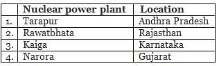
Which of the above pairs are correctly matched?

Detailed Solution for Test: Geography- 7 - Question 1

Tarapur – Maharashtra
Narora – Uttar Pradesh

Test: Geography- 7 - Question 2

What are the reasons for the break in the Indian Monsoon?

  1. The rains fail if the rain bearing storms are not very frequent along the Monsoon trough in northern India.
  2. The break in the monsoon is caused due to the wind blowing along the coast in parallel directions.

Select the correct answer code:

Detailed Solution for Test: Geography- 7 - Question 2

During the south-west monsoon period after having rains for a few days, if rain fails to occur for one or more weeks, it is known as break in the monsoon. These dry spells are quite common during the rainy season. These breaks in the different regions are due to different reasons:
(i) In northern India rains are likely to fail if the rain-bearing storms are not very frequent along the monsoon trough or the ITCZ over this region.
(ii) Over the west coast the dry spells are associated with days when winds blow parallel to the coast.

1 Crore+ students have signed up on EduRev. Have you? Download the App
Test: Geography- 7 - Question 3

Consider the following pairs:

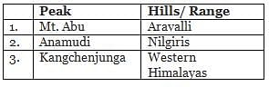
Which of the pairs given above is/are correctly matched?

Detailed Solution for Test: Geography- 7 - Question 3

Anamudi peak is located in Annamalai hills and Kangchenjunga is located in Eastern Himalayas.

Test: Geography- 7 - Question 4

Consider the following statements

  1. Sea of Galilee is mainly situated between Jordan and Israel.
  2. Israel and Jordan shares the border with Red Sea.

Which of the above statements is/are correct?

Detailed Solution for Test: Geography- 7 - Question 4

The Sea of Galilee is Israel’s largest freshwater lake. At 209 meters below sea level, it is the lowest freshwater lake on Earth, and the second lowest lake in the world after the Dead Sea, a saltwater lake.

Test: Geography- 7 - Question 5

Berring strait connects which of the following oceans/seas?

  1. Arctic Ocean
  2. Atlantic Ocean
  3. Pacific Ocean
  4. Mediterranean Sea

Select the correct answer using the codes below.

Detailed Solution for Test: Geography- 7 - Question 5

The Arctic Ocean is located within the Arctic Circle and surrounds the North Pole. It is connected with the Pacific Ocean by a narrow stretch of shallow water known as bering strait.

Test: Geography- 7 - Question 6

Consider the following statements about distribution of salinity in water.

  1. Generally salinity is high in land locked regions compared to estuaries.
  2. The salinity variation in the Pacific Ocean is mainly due to its shape and larger areal extent.
  3. Highest salinity is recorded between 0 to 10-degree latitude because of high temperature and high evaporation.

Which of the above statements is/are correct?

Detailed Solution for Test: Geography- 7 - Question 6
  • All waters in nature, whether rain water or ocean water, contain dissolved mineral salts. Salinity is the term used to define the total content of dissolved salts in sea water. It is calculated as the amount of salt (in gm) dissolved in 1,000 gm (1 kg) of seawater. It is usually expressed as parts per thousand (o/oo) or ppt. Salinity is an important property of sea water. Salinity of 24.7 o/oo has been considered as the upper limit to demarcate ‘brackish water’.
  • In the land locked Red Sea, salinity is as high as 41o/oo, while in the estuaries and the Arctic, the salinity fluctuates from 0 – 35 o/oo, seasonally.
  • The salinity variation in the Pacific Ocean is mainly due to its shape and larger areal extent.
  • The highest salinity is recorded between 15° and 20° latitudes.
  • Maximum salinity (37 o/oo) is observed between 20° N and 30° N and 20° W – 60° W. It gradually decreases towards the north.
  • Maximum salinity (37 o/oo) is observed between 20° N and 30° N and 20° W – 60° W. It gradually decreases towards the north.
Test: Geography- 7 - Question 7

Which among the following countries open out to Lake Victoria?

  1. Uganda
  2. Rwanda
  3. Kenya
  4. Tanzania

Select the correct answer code:

Detailed Solution for Test: Geography- 7 - Question 7

To determine which countries open out to Lake Victoria, we can analyze each option provided.
Uganda:
- Uganda is a country in East Africa.
- Lake Victoria forms the southern border of Uganda, making it one of the countries that open out to the lake.
Rwanda:
- Rwanda is a landlocked country in East Africa.
- It does not have direct access to any of the Great Lakes, including Lake Victoria.
Kenya:
- Kenya is a country in East Africa.
- Lake Victoria forms the western border of Kenya, allowing it to open out to the lake.
Tanzania:
- Tanzania is a country in East Africa.
- Lake Victoria forms the northern border of Tanzania, making it one of the countries that open out to the lake.
Based on the analysis above, the correct answer is option B: 1, 3, 4. Uganda, Kenya, and Tanzania are the countries that open out to Lake Victoria.
Test: Geography- 7 - Question 8

Which of the following is/are the principal tributaries of the Brahmaputra River?

  1. Hindon
  2. Lohit
  3. Sindh
  4. Subansiri
  5. Dibang

Select the correct answer code:

Detailed Solution for Test: Geography- 7 - Question 8

The principal tributaries of Brahmaputra River joining from right are the Lohit, the Dibang, the Subansiri, the Jiabharali, the Dhansiri, the Manas, the Torsa, the Sankosh and the Teesta whereas the Burhi dihing, the Desang, the Dikhow, the Dhansiri and the Kopili joins it from left.
Hindon and Sindh are the tributaries of Yamuna River.

Test: Geography- 7 - Question 9

In which of the following states/UTs you are most likely to find Tropical evergreen forest, semi evergreen, deciduous, Pine and Temperate forests? 

Detailed Solution for Test: Geography- 7 - Question 9

Situated on the northeastern tip of the country, the state of Arunachal Pradesh is a part of Eastern Himalayan Ranges. The important forests types found in the state are Tropical evergreen, semi evergreen, deciduous, Pine, Temperate, Alpine and grassland.

Test: Geography- 7 - Question 10

Which of the following crops require moderate temperature and rainfall during growing season and bright sunshine at the time of harvest? 

Detailed Solution for Test: Geography- 7 - Question 10

For rice, high rainfall, temperature and clayey soil is required which can hold water.
For Cotton, light rainfall is needed. For Jute high rainfall and temperature is needed.
Wheat requires moderate temperature and rainfall during growing season and bright sunshine at the time of harvest. It thrives best in well drained loamy soil.
Maize requires moderate temperature, rainfall and lots of sunshine. It needs well-drained fertile soils.

Test: Geography- 7 - Question 11

Which of the following phenomenon is/are responsible for thunderstorms formation?

  1. Condensation
  2. High temperature and humidity
  3. Orography
  4. Vertical wind

Select the correct answer code:

Detailed Solution for Test: Geography- 7 - Question 11

All are responsible for thunderstorms.
A thunderstorm, is a storm characterized by the presence of lightning and its acoustic effect on the Earth’s atmosphere, known as thunder.
Thunderstorms occur in a type of cloud known as a cumulonimbus. They are usually accompanied by strong winds, and often produce heavy rain and sometimes snow, sleet, or hail, but some thunderstorms produce little precipitation or no precipitation at all.
Thunderstorms result from the rapid upward movement of warm, moist air, sometimes along a front. As the warm, moist air moves upward, it cools, condenses, and forms a cumulonimbus cloud that can reach heights of over 20 kilometres. As the rising air reaches its dew point temperature, water vapor condenses into water droplets or ice, reducing pressure locally within the thunderstorm cell. Any precipitation falls the long distance through the clouds towards the Earth’s surface. As the droplets fall, they collide with other droplets and become larger. The falling droplets create a downdraft as it pulls cold air with it, and this cold air spreads out at the Earth’s surface, occasionally causing strong winds that are commonly associated with thunderstorms.

Test: Geography- 7 - Question 12

Consider the following statements.

  1. Tigris River flows through Turkey and Iraq.
  2. Mekong River flows through parts of Arunachal Pradesh.

Which of the above statements is/are correct?

Detailed Solution for Test: Geography- 7 - Question 12

The Tigris is the eastern of the two great rivers that define Mesopotamia, the other being the Euphrates. The river flows south from the mountains of south-eastern Turkey through Iraq and empties into the Persian Gulf.
The Mekong is a trans-boundary river in Southeast Asia. From the Tibetan Plateau the river runs through China’s Yunnan Province, Myanmar, Laos, Thailand, Cambodia, and Vietnam.

Test: Geography- 7 - Question 13

Consider the following statements.

  1. India’s longest river bridge is Dhola-Sadiya bridge on Lohit River.
  2. Lohit is the tributary of Ganga River.

Which of the above statements is/are incorrect?

Detailed Solution for Test: Geography- 7 - Question 13

Dhola–Sadiya Bridge connects northeast states of Assam and Arunachal Pradesh. The bridge spans the Lohit River, a major tributary of the Brahmaputra River. It is the longest bridge in India over water. However, Kacchi Dargah–Bidupur Bridge under construction in the Indian state of Bihar, is expected to become the longest bridge in India upon its completion.

Test: Geography- 7 - Question 14

Kamlang wildlife sanctuary is located in

Detailed Solution for Test: Geography- 7 - Question 14

The Kamlang Wildlife Sanctuary is situated in the Lohit District of Arunachal Pradesh. The park is named after the Kamlang River which flows through it.

Test: Geography- 7 - Question 15

India’s National Waterway-1 passes through which of the following states

  1. Uttar Pradesh
  2. Bihar
  3. Jharkhand
  4. Chhattisgarh
  5. West Bengal

Select the correct answer code

Detailed Solution for Test: Geography- 7 - Question 15

The NW-1 passes through West Bengal, Jharkhand, Bihar and Uttar Pradesh.

Test: Geography- 7 - Question 16

Consider the following statements regarding Conservation Agriculture (CA).

  1. Conservation Agriculture (CA) is a farming system that can prevent losses of arable land while regenerating degraded lands.
  2. External inputs such as agrochemicals are not applied so that it does not disrupt the biological processes.
  3. It includes crop-livestock integration and the integration of trees and pastures into agricultural landscapes.

Which of the above statements is/are correct?

Detailed Solution for Test: Geography- 7 - Question 16
  • Conservation Agriculture (CA) is a farming system that can prevent losses of arable land while regenerating degraded lands. It promotes maintenance of a permanent soil cover, minimum soil disturbance, and diversification of plant species. It enhances biodiversity and natural biological processes above and below the ground surface, which contribute to increased water and nutrient use efficiency and to improved and sustained crop production.
  • CA principles are universally applicable to all agricultural landscapes and land uses with locally adapted practices. Soil interventions such as mechanical soil disturbance are reduced to an absolute minimum or avoided, and external inputs such as agrochemicals and plant nutrients of mineral or organic origin are applied optimally and in ways and quantities that do not interfere with, or disrupt, the biological processes.
  • Complemented by other known good practices, including the use of quality seeds, and integrated pest, nutrient, weed and water management, etc., CA is a base for sustainable agricultural production intensification. It opens increased options for integration of production sectors, such as crop-livestock integration and the integration of trees and pastures into agricultural landscapes.
Test: Geography- 7 - Question 17

Consider the following statements regarding Wheat Cultivation in India.

  1. Wheat can be grown in the tropical and sub-tropical zones and it cannot tolerate severe cold and snow.
  2. Soils with a clay loam or loam texture and moderate water holding capacity are ideal for wheat cultivation.
  3. Punjab is the largest Wheat producing state of India.

Which of the above statements is/are correct?

Detailed Solution for Test: Geography- 7 - Question 17

Wheat is the main cereal crop in India.
Wheat crop has wide adaptability. It can be grown not only in the tropical and sub-tropical zones, but also in the temperate zone and the cold tracts of the far north, beyond even the 60-degree north altitude. Wheat can tolerate severe cold and snow and resume growth with the setting in of warm weather in spring. It can be cultivated from sea level to as high as 3300 meters.
The best wheat are produced in areas favoured with cool, moist weather during the major portion of the growing period followed by dry, warm weather to enable the grain to ripen properly.
Wheat is grown in a variety of soils of India. Soils with a clay loam or loam texture, good structure and moderate water holding capacity are ideal for wheat cultivation.
Uttar Pradesh is the largest Wheat producing state of India, followed by Punjab, Haryana and Madhya Pradesh.

Test: Geography- 7 - Question 18

Tidal currents are

Detailed Solution for Test: Geography- 7 - Question 18

Tidal currents are the tides which are channelled between islands, bays and estuaries. Tidal current has significance in power generation.

Test: Geography- 7 - Question 19

Consider the following statements:

  1. Area of Pacific Ocean is almost equal to area of all other oceans combined.
  2. More diversity of landforms can be observed in oceans than continents.

Which of the above statements is/are correct?

Detailed Solution for Test: Geography- 7 - Question 19
  • Although Pacific Ocean is the largest ocean than other oceans, its area is far lesser than all other oceans area combined.
  • Continental slope, Guyots, Trenches and other landforms can be observed in the ocean which is far diverse than the continents.
Test: Geography- 7 - Question 20

Which of the following is true about Profundal zone? 

Detailed Solution for Test: Geography- 7 - Question 20

The profundal zone is a very cold zone, such as an ocean or a lake, located below the range of effective light penetration. This is typically below the thermocline, the vertical zone in the water through which temperature drops rapidly. The lack of light in the profundal zone determines the type of biological community that can live in this region, which is distinctly different from the community in the overlying waters. The profundal zone is part of the aphotic zone.

Test: Geography- 7 - Question 21

Earth’s surface temperature is largely influenced by insolation. Which of the following factors influence the insolation?

  1. Rotation of earth
  2. Angle of inclination of sun rays
  3. Length of the day
  4. Transparency of the atmosphere

Select the correct answer code:

Detailed Solution for Test: Geography- 7 - Question 21

All the above factors influence insolation.
Rotation of earth: The rotation of the earth on the inclined axis has a greater influence on the amount of insolation received at different latitudes.
Angle of inclination of sun rays: Since the earth is a geoid resembling a sphere, the sun’s rays strike the surface at different angles at different places. This depends on the latitude of the place. The higher the latitude, the less is the angle they make with the surface of the earth. The area covered by the vertical rays is always less than the slant rays. If more area is covered, the energy gets distributed and the net energy received per unit area decreases. Moreover, the sun’s rays with small angle traverse more of the atmosphere than rays striking at a large angle.
Length of the day: The length of the day determines the duration of sunlight which affects the amount of solar radiation received by the earth’s surface.
Transparency of the atmosphere: Atmosphere is not transparent for all the radiation coming from the sun because of different composition and layers. It is also one of the controlling factors of insolation to reach earth surface.
Earth’s Distance from Sun: The earth is revolving around the sun in an elliptical orbit, resulting continuous change in the distance between sun and the earth on annual basis. It leads to seasonal variation in solar energy received by the earth.  During aphelion the northern hemisphere is facing the sun and therefore receives energy about 7 percent less than the perihelion (southern hemisphere).

Test: Geography- 7 - Question 22

Which of the following rivers flows through Kaziranga National Park.

  1. Brahmaputra
  2. Diphlu
  3. Dharla
  4. Mora Diphlu
  5. Rangpo

Select the correct answer code:

Detailed Solution for Test: Geography- 7 - Question 22

Kaziranga is crisscrossed by four main rivers — Brahmaputra, Diphlu, Mora Diphlu and Mora Dhansiri and has numerous small water bodies.

Test: Geography- 7 - Question 23

Consider the following statements regarding Jet Streams.

  1. Jet streams are narrow bands of strong winds that flow over thousands of kilometres predominantly from east to west.
  2. Major jet streams are found near the upper levels of the atmosphere, around 9 to 16 km from the earth’s surface.
  3. In India, the Tropical jet stream influences the formation and duration of the summer monsoon.
  4. Jet streams aid in the faster travelling of Aircrafts.

Which of the above statements is/are correct?

Detailed Solution for Test: Geography- 7 - Question 23
  • The Boeing 747-436 plane was able to achieve a speed of 1,327 kph as it was aided by a strong jet stream generated due to Storm Ciara.
  • Jet streams are narrow bands of strong winds that flow over thousands of kilometres from west to east. Major jet streams are found near the upper levels of the atmosphere, around 9 to 16 km from the earth’s surface, and can reach speeds of over 320 kph.
  • The jet streams shift to the north or south depending on the season. During winters, the wind current is the strongest. They are also closer to the Equator during winter.
  • The major jet streams are the Polar Front, Subtropical, and Tropical jet streams. In India, the Tropical jet stream influences the formation and duration of the summer monsoon.
  • Most commercial planes fly at the jet stream level, and a strong jet stream can provide a potent tailwind to a flight travelling from west to east, like the British Airways flight, which flew from New York to London. This helps reduce the travel time for such flights, as their speeds are boosted.
Test: Geography- 7 - Question 24

Equatorial counter-currents are unique because 

Detailed Solution for Test: Geography- 7 - Question 24
  • Equatorial counter-currents are major surface flows that carry water eastward in the Atlantic, Indian, and Pacific Oceans.
  • They are located near the equator and are sandwiched between two westward-flowing currents, the North Equatorial Current and the South Equatorial Current.
  • Equatorial counter-currents are unique, in that they flow in the opposite direction of the surface winds. The other major surface currents in the tropics flow in the same direction as the prevailing winds.
Test: Geography- 7 - Question 25

Consider the following statements regarding Coffee Production in India.

  1. Coffee is grown in three regions of India with Karnataka, Kerala and Tamil Nadu forming the traditional coffee growing region.
  2. Karnataka accounts for around 90% of Coffee production in India.
  3. India is not among the top five coffee producing countries in the world.

Which of the above statements is/are correct?

Detailed Solution for Test: Geography- 7 - Question 25
  • Coffee production in India is dominated in the hill tracts of South Indian states, with Karnataka accounting for 71%, followed by Kerala with 21% and Tamil Nadu.
  • Coffee is grown in three regions of India with Karnataka, Kerala and Tamil Nadu forming the traditional coffee growing region, followed by the new areas developed in the non-traditional areas of Andhra Pradesh and Orissa in the eastern coast of the country and with a third region comprising the states of Assam, Manipur, Meghalaya, Mizoram, Tripura, Nagaland and Arunachal Pradesh of Northeastern India.
  • The two well-known species of coffee grown are the Arabica and Robusta.
  • Almost 80% of Indian coffee is exported.
  • India is the 7th largest coffee producing country in the world. Brazil is the world’s largest coffee producer.
Information about Test: Geography- 7 Page
In this test you can find the Exam questions for Test: Geography- 7 solved & explained in the simplest way possible. Besides giving Questions and answers for Test: Geography- 7, EduRev gives you an ample number of Online tests for practice

Top Courses for UPSC

Download as PDF

Top Courses for UPSC