The Matsya Mahajanapada of the 6th century B.C. was located in the region that corresponds to present-day Alwar and Bharatpur districts of Rajasthan and parts of northeastern Rajasthan and southwestern Haryana.
Hence, the Correct Answer - Option B
Red Sea is bordered by which of the following African countries?
Which of the pairs given above are correctly matched?
What is the correct sequence of occurrence of the following Lakes from West to East ?
Select the correct answer using the code given below.
Which of the following countries does the Prime Meridian pass?
Which of the pairs given above are correctly matched?
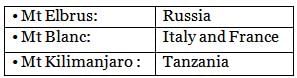
Consider the following pairs:
Which of the pairs given above are correctly matched?
Consider the following statements with reference to continent of Africa:
Select the incorrect answer using the code given below.
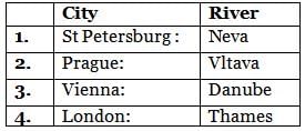
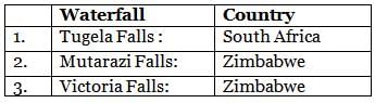
Consider the following pairs:
Which of the pairs given above are correctly matched?
Consider the following pairs:
Which of the pairs given above are correctly matched?
What is the correct sequence of occurrence of the following from East to West?
Select the correct answer using the code given below.
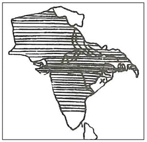
The following map shows four of the sixteen mahajanapadas that existed in ancient India:
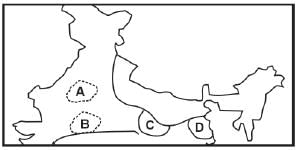
The places marked A, B, C and D respectively are:
Which of the following State(s) of India share border with Myanmar?
1. Nagaland
2. Manipur
3. Arunachal Pradesh
Select the correct answer using the code given below:
Which of the following countries are part of the Great Green Wall Initiative?
Select the correct answer using codes below
Which of the following countries border Lake Chad in Africa?
Select the correct answer using the code given below.
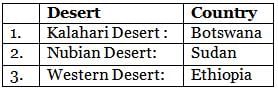
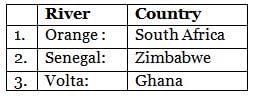
Consider the following pairs:
Which of the pairs given above are incorrectly matched?
It is the isolated UK Overseas Territory and the world’s most remote human settlement. It has been recently declared the largest fully protected marine reserves in the Atlantic Ocean under the UK’s Blue Belt Programme.
Q. Which of the following is described above?
What is the correct sequence of occurrence of the following Island Countries from north to south?
Select the correct answer using the code given below.
Which of the following listed countries are landlocked?
Which of the pairs given above are correctly matched?
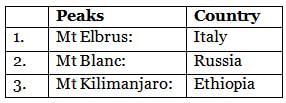
Consider the following pairs:
Q. Which of the pairs given above are correctly matched?
Matsya Mahajanapada of 6th Century B.C. was located on:
|
© EduRev
|
Education Revolution
|


|