Geography: CUET Mock Test - 5 - CUET MCQ
30 Questions MCQ Test - Geography: CUET Mock Test - 5

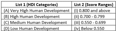
Match List I with List II
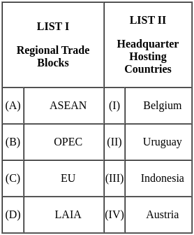
Choose the correct answer from the options given below:
Choose the correct answer from the options given below:

Green Revolution is successful in North Western part of the country, select the reasons.
A. Ample rainfall
B. Use of high yielding varieties of seeds
C. Easily available local labour
D. More employment pressure on agriculture
E. 85% net sown area is cultivated through irrigation
Choose the correct answer from the options given below:
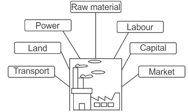
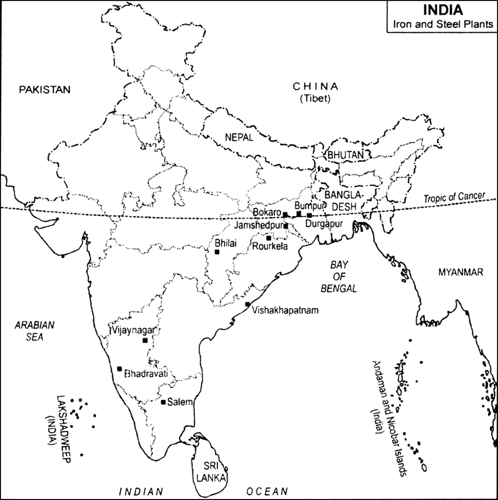
In India iron and steel industries located in ________
Consider the following statements with respect to Settlements:
1. The Clustered Rural Settlement is a compact or closely built-up area of houses.
2. In Semi-Clustered Settlements one or more sections of the village society choose or are forced to live a little away from the main cluster or village.
3. The Urban Settlements are generally compact and larger in size and engaged in a variety of nonagricultural, economic and administrative functions.
Which of the above statements are correct?
Analyze the meaning of the 'Polluter Pays' principle and identify the correct statements
A. The party responsible for producing pollution is responsible for paying for the damage done to the natural environment.
B. As an application of this principle, retailers are no longer allowed to give away free plastic bags; customers must either pay for one or take along their own bag. Customers are recognized as the polluters
C. As a consequence of this principle, the government is expected to bear the costs of both preventing and remedying the cause of pollution and passing on all the associated costs that he taxpayers
Choose the correct answer from the options given below
The environment problems that has been addressed in the above passage is
Based on the paragraph, one can say, that to address environmental issues anywhere
To find a sustainable solution to the problems of Daurala, few measures were adopted by the NGO and civic authorities. Which of the following steps was NOT part of the scheme?
Which of the following was done in Daurala village?
A. Plantation of 10000 trees
B. The overhead water tank's capacity was enhanced
C. 900 m extra Pipeline was laid
D. Construction of rainwater harvesting structure
Choose the most appropriate answer from the options given below:
Which of the following statements are correct?
(A) Human Development is measured using the Human Development Index (HDI).
(B) The HDI considers only economic factors for ranking countries.
(C) Life expectancy at birth is an indicator of health in HDI.
(D) A country with high HDI has high economic growth.
(E) HDI includes education as one of its key dimensions.
Choose the correct answer from the options given below:
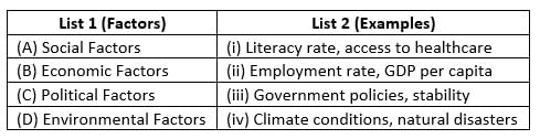
Match List-I with List-II :
Choose the correct answer from the options given below :
Match List-I with List-II :
Choose the correct answer from the options given below :
Match List-I with List-II :

Choose the correct answer from the options given below :
Match List-I with List-II :
Choose the correct answer from the options given below :
The boundaries between sub-fields of human geography often what?
Which of the following is not the major field of geography?
Read the case study given below and answer the questions that follow:
There are three components of population change – births, deaths and migration.
Death rate plays an active role in population change. Population growth occurs not only by increasing births rate but also due to decreasing death rate. Crude Death Rate (CDR) is a simple method of measuring mortality of any area. CDR is expressed in terms of number of deaths in a particular year per thousand of population in a particular region.
By and large mortality rates are affected by the region’s demographic structure, social advancement and levels of its economic development.
Which method is used for measuring the mortality of an area?
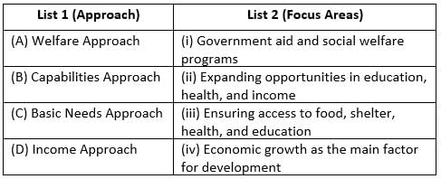
Which approach to human development is associated with Prof. Amartya Sen?
Which approach argues that government expenditure should focus on providing basic needs such as food, water, and housing?
Which of the following statements best describes the difference between growth and development?
Which century witnessed attempts of explorations in Europe, and slowly the myths and mysteries about countries and people started to open up?
According to Ratzel, “Human geography is the synthetic study of the relationship between human societies and earth’s_________.”
Electoral Geography is the part of which field of geography?
Why are the Ganga plains among the world's most densely populated areas, whereas the Himalayan mountain zones are less populated?
Most of India's foreign trade is carried through __________ .
Important Questions for Geography: CUET Mock Test - 5
Geography: CUET Mock Test - 5 MCQs with Answers
Online Tests for Geography: CUET Mock Test - 5
|
© EduRev
|
Education Revolution
|


|


within 7 days!