Humanities/Arts Exam  >  Humanities/Arts Tests  >  Geography: CUET Mock Test - 8 - Humanities/Arts MCQ

Geography: CUET Mock Test - 8 - Humanities/Arts MCQ


Test Description

30 Questions MCQ Test - Geography: CUET Mock Test - 8

Geography: CUET Mock Test - 8 for Humanities/Arts 2025 is part of Humanities/Arts preparation. The Geography: CUET Mock Test - 8 questions and answers have been prepared according to the Humanities/Arts exam syllabus.The Geography: CUET Mock Test - 8 MCQs are made for Humanities/Arts 2025 Exam. Find important definitions, questions, notes, meanings, examples, exercises, MCQs and online tests for Geography: CUET Mock Test - 8 below.
Solutions of Geography: CUET Mock Test - 8 questions in English are available as part of our course for Humanities/Arts & Geography: CUET Mock Test - 8 solutions in Hindi for Humanities/Arts course. Download more important topics, notes, lectures and mock test series for Humanities/Arts Exam by signing up for free. Attempt Geography: CUET Mock Test - 8 | 50 questions in 45 minutes | Mock test for Humanities/Arts preparation | Free important questions MCQ to study for Humanities/Arts Exam | Download free PDF with solutions
Geography: CUET Mock Test - 8 - Question 1

Other than flavourings, what is used to manufacture chewing gum?

Detailed Solution for Geography: CUET Mock Test - 8 - Question 1

Chicle is the word given to the part of the chewing gum that has lost its flavour and is manufactured from the milky juice of the zapota tree.

Geography: CUET Mock Test - 8 - Question 2

India accounts for about _____ percent of the World's surface area.

Detailed Solution for Geography: CUET Mock Test - 8 - Question 2

India accounts for about 2.45% of the World's surface area.

Key Points

  • India, the seventh-largest country by land area, covers approximately 3.28 million square kilometers.
  • The total surface area of the Earth is about 510 million square kilometers, which means India's land area is a small fraction of the global total.
  • The percentage of 2.45% represents India's significant but relatively small geographical footprint on the global scale.
  • This geographical area of India includes diverse terrain, ranging from the snow-capped Himalayas in the north to the coastal plains in the south.
  • Despite its relatively small size in terms of global land area percentage, India is the second-most populous country in the world, highlighting a high population density.

Additional Information

  • India's diverse ecosystems range from the Thar Desert in the west to the wettest place on Earth, Mawsynram, in the northeast.
  • It has a coastline of about 7,517 kilometers, touching the Indian Ocean, the Arabian Sea, and the Bay of Bengal.
  • The country's geographical diversity supports a wide range of flora and fauna, making it one of the world's 17 mega-diverse countries.
Geography: CUET Mock Test - 8 - Question 3

The Jal Kranti Abhiyan was launched in ____.

Detailed Solution for Geography: CUET Mock Test - 8 - Question 3

The correct answer is 2015 -16.

Key Points

  • The Jal Kranti Abhiyan was launched by the Government of India to consolidate water conservation and management through a holistic and integrated approach.
  • The campaign aims to make water conservation a public movement and bring about a significant change in the way water is used and conserved.
  • It was initiated to enhance water security, especially in rural areas, through various interventions including rainwater harvesting, renovation of traditional and other water bodies/tanks, reuse of water and recharging of structures, watershed development, and intensive afforestation.
  • The Abhiyan also seeks to promote efficient water use for irrigation and better crop choice to maximize the per unit water productivity.
  • The mission was launched in response to the urgent need for water conservation in India, where many regions face severe water scarcity.

Additional Information

  • The Abhiyan also focuses on empowering village communities to manage their water resources and ensuring the involvement of various stakeholders in the management of water resources.
  • It was a step forward towards creating a Jan Andolan for water, thereby making water conservation a people's movement and integrating it into the national consciousness.
Geography: CUET Mock Test - 8 - Question 4
National Waterway 2 stretch extends between ____.
Detailed Solution for Geography: CUET Mock Test - 8 - Question 4

Sadiya-Dhubri.

India's National Waterways are a part of its initiative to promote inland water transport and reduce the pressure on road and rail networks. Each waterway has a unique stretch that serves specific logistical and connectivity purposes.

Key Points

  • Sadiya-Dhubri
    • This is the correct answer for National Waterway 2 (NW2).
    • National Waterway 2 stretches from Sadiya to Dhubri in Assam, covering a distance of about 891 kilometers.
    • It navigates across the Brahmaputra river. NW2 is crucial for the northeastern region of India, providing an economic and efficient mode of transport for cargo and passengers.
    • This waterway enhances connectivity not only within Assam but also with other northeastern states and neighboring countries such as Bhutan.

Additional Information

  • Allahabad-Haldia
    • This stretch is known as National Waterway 1 (NW1).
    • It is one of the most significant waterways in India, extending from Haldia in West Bengal to Prayagraj (formerly Allahabad) in Uttar Pradesh.
    • Spanning around 1620 kilometers, NW1 is navigable by mechanized vessels and plays a crucial role in transporting bulk goods and passengers in the Ganga river basin.
    • It's essential for the economic development of the region, facilitating trade to and from the northeastern states as well as Nepal and Bangladesh through the Indo-Bangladesh Protocol route.
  • Kottapuram-Kollam
    • This stretch corresponds to National Waterway 3 (NW3), often referred to as the West Coast Canal or Kerala Waterway.
    • It extends from Kottapuram to Kollam in Kerala, including the Udyogmandal and Champakara canals, covering a distance of about 205 kilometers.
    • It is the first National Waterway in India to be developed with a 24-hour navigational facility along its entire stretch. NW3 plays a vital role in transporting men and material along the densely populated and industrially active coast of Kerala.
  • Patna-Haldia
    • This option seems to be a variant or part of National Waterway 1 (NW1) mentioned earlier and could cause confusion by its listing.
    • There is no distinct National Waterway named "Patna-Haldia" as Patna is within the stretch of NW1 (Haldia to Allahabad).
    • Hence, while Patna and Haldia are significant points on National Waterway 1, there isn't a separate waterway designated as Patna-Haldia.
Geography: CUET Mock Test - 8 - Question 5
____ port is situated at the Zuari estuary.
Detailed Solution for Geography: CUET Mock Test - 8 - Question 5

Marmagao

Key Points

  • Marmagao
    • This is the correct answer. The Mormugao port (often spelled Marmagao) is one of the premier iron ore exporting ports of India, located in Goa on the west coast.
    • It is situated at the mouth of the Zuari River, making it strategically important for mineral exports.
    • The port handles a significant amount of the country's mineral and iron ore exports.
    • Its location on the Zuari estuary allows it to serve not just international trade but also local economic activities in the state of Goa.

Additional Information

  • Kandla
    • Kandla port, officially known as Deendayal Port, is located in the Kutch District of Gujarat state in western India.
    • It is one of India's major ports on the west coast, primarily developed to ease the pressure on the port of Mumbai post-partition.
    • Kandla is a tidal port that plays a crucial role in the country's grain exports, as well as imports of oil and chemicals.
    • It is located on the Gulf of Kutch and is vital for western India's economic activities but is not situated at the Zuari estuary.
  • New Mangalore
    • The New Mangalore Port is situated in Karnataka, also on the west coast of India.
    • It lies north of the confluence of the Gurupura (Phalguni) and Netravathi rivers and primarily deals with the export of Karnataka's major commodities such as iron ore concentrates, manganese, coffee, and cashew nuts.
    • The port acts as an important link for the export and import trade of Karnataka and the inland regions. However, it is not located at the Zuari estuary.
  • Paradwip
    • Paradip Port is a deep-water port located in Odisha, along the eastern coast of India, at the confluence of the Mahanadi River and the Bay of Bengal.
    • It handles a vast array of cargo, including crude oil, iron ore, and coal, making it one of the major ports contributing to the mineral export-import trade in the eastern part of India.
    • It plays a pivotal role in serving the eastern and central parts of the country but is not associated with the Zuari estuary.
Geography: CUET Mock Test - 8 - Question 6
As per Census of India 2011, the population density was highest in ______.
Detailed Solution for Geography: CUET Mock Test - 8 - Question 6

The correct option is ' Bihar'.

Key Points

  • "Bihar":
    • As per the Census of India 2011, Bihar had the highest population density among all Indian states.
    • Population density is calculated as the number of people living per unit area of land, and Bihar's high density is indicative of a large population living in a relatively small geographical area.
    • This high density has implications for resource allocation, urban planning, and governance in the state.

Additional Information

  • "West Bengal":
    • Although West Bengal is one of the densely populated states in India, it did not have the highest population density as per the Census of India 2011.
    • It is known for its large urban population, particularly in and around the city of Kolkata.
  • "Uttar Pradesh":
    • Uttar Pradesh is the most populous state in India, but when it comes to population density, it was not the highest as per the 2011 Census.
    • The state's large geographic area helps moderate its population density.
  • "Goa":
    • Goa, being the smallest state in terms of area, has a relatively low population, making its population density also lower compared to Bihar.
    • It is known for its tourist-friendly coastal region and higher per capita income.

In conclusion, Bihar's high population density as per the Census of India 2011 highlights the challenges and considerations for resource management, urban development, and governance in densely populated regions.

Geography: CUET Mock Test - 8 - Question 7
Through which of the following canal route, maximum international trade is taking place?
Detailed Solution for Geography: CUET Mock Test - 8 - Question 7

The correct answer is Panama Canal.

Key Points

  • Panama Canal
    • It is an artificial 82 km (51 mi) waterway in Panama that connects the Atlantic Ocean with the Pacific Ocean.
    • It divides North and South America.
    • It facilitates major trade between Asia and the U.S. Asia - East Coast U.S is busiest vessel trade route.
    • The maximum international trade takes place through this canal.
    • The Panama Canal had a record fiscal year 2021 with more tonnage transported through the waterway than ever before.

Additional Information

  • Suez Canal
    • It is an artificial sea-level waterway in Egypt, connecting the Mediterranean Sea to the Red Sea.
    • It is a popular trade route between Europe and Asia.
    • The canal is operated and maintained by the state-owned Suez Canal Authority (SCA) of Egypt.
    • Approximately 12% of global trade passes through the Suez canal, representing 30% of all global container traffic, and over USD $1 trillion worth of goods per annum.
  • The English Channel is an arm of the Atlantic Ocean that separates Southern England from northern France.
    • It links to the southern part of the North Sea by the Strait of Dover at its northeastern end.
  • The Kiel Canal is a 98 km long freshwater canal.
    • It is in the German state of Schleswig-Holstein.
    • The canal was finished in 1895, but was later widened.
    • It links the North Sea at Brunsbüttel to the Baltic Sea at Kiel-Holtenau.
Geography: CUET Mock Test - 8 - Question 8

Which among the following is not a biodegradable pollutant?

Detailed Solution for Geography: CUET Mock Test - 8 - Question 8

The correct answer is Option 3.

Key Points

Non-biodegradable pollutants:

  • Those pollutants which cannot be broken down into simpler, harmless substances in nature, are called non-biodegradable pollutants.
  • DDT, plastics, polythene, bags, insecticides, pesticides, mercury, lead, arsenic, metal articles like aluminium cans, synthetic fibres, glass objects, iron products and silver foils are non-biodegradable pollutants. Hence, Option 3 is correct.

Additional Information

Biodegradable pollutants.

  • Those pollutants which can be broken down into simpler, harmless, substances in nature in due course of time (by the action of micro-organisms like certain bacteria) are called biodegradable pollutants.
  • Domestic wastes (garbage), urine, faecal matter, sewage, agriculture residues, paper, wood, cloth, cattle dung, animal bones, leather, wool, vegetable stuff, or plants are biodegradable pollutants.
Geography: CUET Mock Test - 8 - Question 9
Which one of the following is the main cause of land degradation in Punjab?
Detailed Solution for Geography: CUET Mock Test - 8 - Question 9

The correct answer is over-irrigation.

Key Points

  • In Punjab the major cause of land degradation is over-irrigation.
  • Since a large number of farmers now use tube-wells for the irrigation of their fields, they potentially over irrigate the land to save the frequency of irrigation and also to make the soil suitable for higher moisture required crops.
  • This leads to an increased level of salinity in the soil which degrades the quality of the soil.
  • Uttar Pradesh and Haryana also face land degradation due to over-irrigation.

Additional Information

  • Overgrazing is the main cause of land degradation in states like Maharashtra, Madhya Pradesh, Rajasthan, Gujarat.
  • Deforestation caused due to mining activities is another major cause of land degradation in states like Odisha, Jharkhand, Chhattisgarh, Madhya Pradesh.
  • Intensive cultivation can lead to a decrease in soil fertility. The decline in organic matter, nutrients, and degradation of physical properties of soil is found in soils that are intensively cultivated with cereal crops like rice and maize. This is a common phenomenon in hill states of the North East.
Geography: CUET Mock Test - 8 - Question 10
Which of the following is NOT a green house gas?
Detailed Solution for Geography: CUET Mock Test - 8 - Question 10

The correct answer is Argon.

Key Points

Greenhouse gas:

  • A greenhouse gas is a gas that absorbs and emits infrared radiation.
  • They absorb infrared energy (heat energy) emitted from the earth’s surface and reradiate it back to the earth’s surface.
  • The greenhouse gases trap heat in the earth’s atmosphere and warm the planet.
  • In simple terms, gases that trap heat in the earth’s atmosphere are known as Greenhouse Gases, abbreviated as GHGs.
  • They contribute to the Greenhouse Effect, which is the resultant heating effect.
  • The Primary GHGs are:
    • Water Vapour
    • Carbon dioxide
    • Methane
    • Nitrous oxide
    • Ozone
  • Other GHGs are carbon monoxide, fluorinated gases, chlorofluorocarbons (CFCs), black carbon (soot), and brown carbon.
  • Among the greenhouse gases, only water vapour can absorb both incoming (UV) and outgoing (infrared) radiation.
Geography: CUET Mock Test - 8 - Question 11

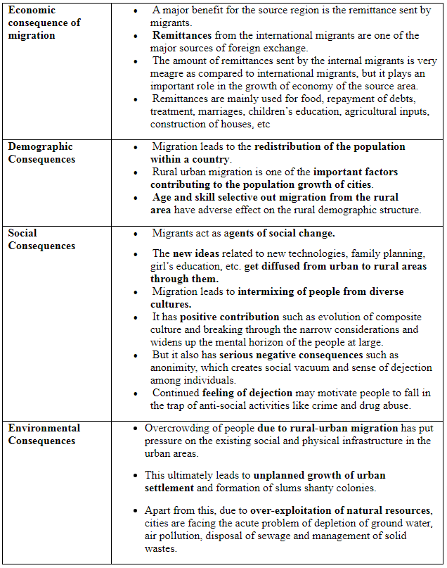
Match List I with List II

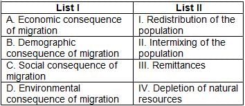
Choose the correct answer from the options given below:

Detailed Solution for Geography: CUET Mock Test - 8 - Question 11

The correct answer is Option 4.

Key Points

  • Migration is a response to the uneven distribution of opportunities over space.
  • People tend to move from place of low opportunity and low safety to the place of higher opportunity and better safety.
  • This, in turn, creates both benefits and problems for the areas, people migrate from and migrate to.
  • Consequences can be observed in economic, social, cultural, political and demographic terms

Geography: CUET Mock Test - 8 - Question 12

Which theory may be applied to characterise and forecast the demographics of any location?

Detailed Solution for Geography: CUET Mock Test - 8 - Question 12

Demographic transition theory can be used to describe and predict the future population of any area. The theory tells us that population of any region changes from high births and high deaths to low births and low deaths as society progresses from rural agrarian and illiterate society to urban industrial and literate society. These changes occur in stages which are collectively known as the demographic cycle.

Geography: CUET Mock Test - 8 - Question 13

Which index measures the shortfall in human development?

Detailed Solution for Geography: CUET Mock Test - 8 - Question 13

The poverty index is related to the Human Development Index. This index measures the shortfall in human development. It is a non-income measure. The probability of not surviving till the age of 40, the adult illiteracy rate, the number of people who do not have access to clean water, and the number of small children who are underweight are all taken into account to show the shortfall in human development in any region. Often the human poverty index is more revealing than the Human Development Index.

Geography: CUET Mock Test - 8 - Question 14

Which of the following pack animals is preferred for mountainous areas?

Detailed Solution for Geography: CUET Mock Test - 8 - Question 14

Mules are preferred in mountainous regions. A mule is the offspring of a male donkey (jack) and a female horse (mare). Mules have harder hooves than horses which make them great for rocky terrain. Mules' hooves are less likely to split or crack and can withstand mountainous trails and rocky farm soil. For many owners around the world who may not be able to regularly replace horseshoes, mules are cheaper to keep.

Geography: CUET Mock Test - 8 - Question 15

Directions: Read the following passage carefully:

Mining requires large areas that need to be cleared prior to mining activities. Large scale deforestation results in the loss of oxygen producing plants and the destruction of vital habitats. Among other ill-effects of deforestation, the prime one is that it reduces overall biodiversity of an area. Mining utilises a variety of poisonous chemicals which can leak into nearby water supplies or evaporate into the air, bringing them into contact with humans, and wildlife.

Q. Profitability of mining does not depend on:

Detailed Solution for Geography: CUET Mock Test - 8 - Question 15

The profitability of mining activities is determined by two major factors:
Physical characteristics: They include deposit size, grade, and method of occurrence.
Economic considerations such as mineral demand, accessible and used technology, capital to create infrastructure, and labour and transportation costs.

Geography: CUET Mock Test - 8 - Question 16

Which of the following time-periods marked the emergence of three new disciplines pertaining to geography?

Detailed Solution for Geography: CUET Mock Test - 8 - Question 16

Discontentment with the quantitative revolution and its dehumanised manner of doing geography led to the emergence of three new schools of thought of human geography (emergence of humanistic, radical and behavioural) in the 1970s. Human geography was made more relevant to the socio-political reality by the emergence of these schools of thought.

Geography: CUET Mock Test - 8 - Question 17

Which of the following is inevitable in enlarging people's choice?

Detailed Solution for Geography: CUET Mock Test - 8 - Question 17

Building people's capabilities in the area of education is important in enlarging their choices.For example, an uneducated child cannot make the choice to be a doctor because his/her choice has got limited due to lack of education. Similarly, very often poor people cannot choose to take medical treatment for disease because their choice is limited by their lack of resources. It is interesting to see to which group most of the school dropouts belong to. This should, then lead to an understanding of the reasons for such behaviour. In India, a large number of women and persons belonging to socially and economically backward groups drop out of school. This shows how the choices of these groups get limited by not having access to knowledge.

Geography: CUET Mock Test - 8 - Question 18

Which of the following statements is/are true in context of manganese and its production in India?

Detailed Solution for Geography: CUET Mock Test - 8 - Question 18

Manganese is an important raw material for smelting of iron ore and also used for manufacturing ferro alloys. Manganese deposits are found in almost all geological formations, however, it is mainly associated with the Dharwar system. Odisha is the leading producer of Manganese. Major mines in Odisha are located in the central part of the iron ore belt of India.

Geography: CUET Mock Test - 8 - Question 19

Which of the following is/are correct?

1. The French established cocoa and coffee plantations in West Africa.
2. The British set up large tea gardens in India and Sri Lanka.
3. Rubber plantations were created in Malaysia and sugarcane and banana plantations were created in South America.

Detailed Solution for Geography: CUET Mock Test - 8 - Question 19

In West Africa, the French planted cocoa and coffee. Large tea plantations were established by the British in Sri Lanka and India, as well as rubber plantations in Malaysia and sugarcane and banana plantations in the West Indies. In the Philippines, sugarcane and coconut crops received significant Spanish and American investment.

Geography: CUET Mock Test - 8 - Question 20

Which of the following waterways belongs to the Europe?

Detailed Solution for Geography: CUET Mock Test - 8 - Question 20

The Danube Waterway: This important inland waterway serves Eastern Europe. The Danube river rises in the Black Forest and flows eastwards through many countries. It is navigable up to Taurna Severin. The chief export items are wheat, maize, timber, and machinery.

Geography: CUET Mock Test - 8 - Question 21

The process of migration from plain areas to pastures on mountains during summers and again from mountain pastures to plain areas during winters is known as:

Detailed Solution for Geography: CUET Mock Test - 8 - Question 21

Movement in search of pastures is undertaken either over vast horizontal distances or vertically from one elevation to another in the mountainous regions. The process of migration from plain areas to pastures on mountains during summers and again from mountain pastures to plain areas during winters is known as transhumance. In mountain regions such as Himalayas, Gujjars, Bakarwals, Gaddis and Bhotiyas migrate from plains to the mountains in summers and to the plains from the high altitude pastures in winters. Similarly, in the tundra regions, the nomadic herders move from south to north in summers and from north to south in winters.

Geography: CUET Mock Test - 8 - Question 22

Which of the following groupings of cities has been done according to ascending order of their size of population?

Detailed Solution for Geography: CUET Mock Test - 8 - Question 22

The group 'Greater Mumbai, Kolkata, Delhi, Chennai' shows the cities arranged in the 'sequence of their ranks' in size.
Greater Mumbai, Kolkata, Delhi, Chennai cities have the population of 16.4 million, 13.22 million, 12.79 million, and 6.42 million, respectively.
India is the seventh biggest country in the world by region, and a country this big has a population to match. In detail, the country has 39 cities which have a population of one million residents.

Geography: CUET Mock Test - 8 - Question 23

As a matter of custom, each community possesses a well-defined region. Which of the following activities is characterised by the above-mentioned line?

Detailed Solution for Geography: CUET Mock Test - 8 - Question 23

Nomadic herding is a prehistoric subsistence activity in which herders rely on animals for food, clothing, shelter, tools, and transportation. They travel from one location to another with their animals, depending on the availability and quality of pastures and water. As a matter of custom, each nomadic society has a distinct region.

Geography: CUET Mock Test - 8 - Question 24

Which of the following is not a method for distinguishing traditional industrial regions?

Detailed Solution for Geography: CUET Mock Test - 8 - Question 24

Traditional industrial regions are distinguished by a high share of manufacturing jobs, high-density dwellings, frequency of low quality, and inadequate services, unappealing surroundings (such as pollution and rubbish dumps), unemployment, emigration, and abandoned land regions created by factory closures due to a global drop in demand.

Geography: CUET Mock Test - 8 - Question 25

Which one is the oldest approach in human development?

Detailed Solution for Geography: CUET Mock Test - 8 - Question 25

Income Approach is one of the oldest approaches to human development. Human development is seen as being linked to income. The idea is that the level of income reflects the level of freedom an individual enjoys. The higher the level of income, the higher is the level of human development.

Geography: CUET Mock Test - 8 - Question 26

Why do humans favour living in flat, mild terrain?

Detailed Solution for Geography: CUET Mock Test - 8 - Question 26

People prefer living on flat plains and gentle slopes. This is because such areas are favourable for the production of crops and to build roads and industries. The mountainous and hilly areas hinder the development of transport network and, hence initially do not favour agricultural and industrial development. So, these areas tend to be less populated. The Ganga plains are among the most densely populated areas of the world, while the mountain zones in the Himalayas are scarcely populated.

Geography: CUET Mock Test - 8 - Question 27

The Human Development Index and the Human Poverty Index are two important indices used by the ___________ to measure human development.

Detailed Solution for Geography: CUET Mock Test - 8 - Question 27

Since 1990, the United Nations Development Programme (UNDP) has been publishing the Human Development Report every year. This report provides a rank-wise list of all member countries according to the level of human development. The Human Development Index and the Human Poverty Index are two important indices used by the UNDP to measure human development.

Geography: CUET Mock Test - 8 - Question 28

India occupies 2.4% of the world's land area and contributes to 15% of the world's population. In 10 years between 1991 and 2001, our population grew by nearly 21%.

Q. Which of the following factors will affect the population growth rates of a place?

i. Emigration
ii. Immigration
iii. Number of births

Detailed Solution for Geography: CUET Mock Test - 8 - Question 28

Births will add more individuals to the population, as will immigration, where people come in to a foreign country to live. Emigration is the act of leaving a resident country or place of residence with the intent to settle elsewhere. All these factors determine the rate at which the population of the country will grow. Thus, option D is correct.

Geography: CUET Mock Test - 8 - Question 29

Which of the following characteristics define(s) the early colonial period?

Detailed Solution for Geography: CUET Mock Test - 8 - Question 29

Exploration and description are the approaches of early colonial period. Imperial and trade interests prompted the discovery and exploration of new areas. An encyclopaedic description of the area formed an important aspect of the geographer's account. Elaborate description of all aspects of a region was not undertaken until later colonial period.

Geography: CUET Mock Test - 8 - Question 30

When did the transportation revolution occur in the eighteenth century?

Detailed Solution for Geography: CUET Mock Test - 8 - Question 30

Most of the movement of goods and services takes place over land. In early days, humans themselves were carriers. Later, animals were used as beasts of burden. With the invention of the wheel, the use of carts and wagons became important. The revolution in transport came about only after the invention of the steam engine in the eighteenth century. Perhaps, the first public railway line was opened in 1825 between Stockton and Darlington in northern England and then onwards, railways became the most popular and fastest form of transport in the nineteenth century.

View more questions
Information about Geography: CUET Mock Test - 8 Page
In this test you can find the Exam questions for Geography: CUET Mock Test - 8 solved & explained in the simplest way possible. Besides giving Questions and answers for Geography: CUET Mock Test - 8, EduRev gives you an ample number of Online tests for practice
Download as PDF