Geography: CUET Mock Test - 9 - CUET MCQ
30 Questions MCQ Test - Geography: CUET Mock Test - 9

Which is the only country in the world that uses Gross National Happiness as a metric for measuring progress?
How can local communities contribute to adapting to climate change?

Which of the following is NOT listed as a strategy for adapting to climate change?
What is the significance of adaptation in the context of climate change?
Why are forests and oceans crucial in combatting climate change?
What is the primary goal of the Paris Agreement signed by world leaders in 2015?
What is the role of the Survey of India in land use classification?
What differentiates forest area from actual forest cover?
What type of land cannot be cultivated under current technology?
What is a common use of land under pastures and grazing?
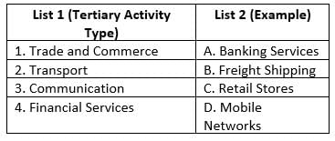
Match List-I with List-II :
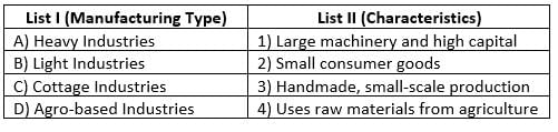
Choose the correct answer from the options given below :
Match List-I with List-II :
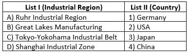
Choose the correct answer from the options given below :
Match List-I with List-II :
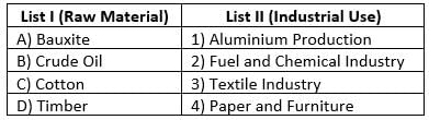
Choose the correct answer from the options given below :
Match List-I with List-II :
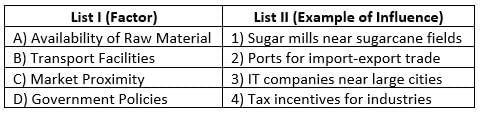
Choose the correct answer from the options given below :
Match List-I with List-II :
Choose the correct answer from the options given below :
Which of the following statements are correct?
(A) Secondary activities involve the transformation of raw materials into finished products.
(B) Manufacturing industries are considered part of tertiary activities.
(C) Large-scale industries usually require significant capital investment and skilled labor.
(D) Cottage industries mainly use advanced machinery for production.
(E) Secondary activities play a crucial role in economic development by adding value to raw materials.
Choose the correct answer from the options given below:
Which of the following statements are correct?
(A) Footloose industries are not dependent on specific raw material locations.
(B) Agro-based industries include cotton textiles and sugar mills.
(C) Heavy industries focus on small consumer goods like electronics.
(D) Iron and steel plants are typically located near coal or iron ore deposits.
(E) Light industries usually produce perishable goods that require quick transportation.
Choose the correct answer from the options given below:
Which of the following statements are correct?
(A) Availability of raw materials is a key factor in determining industrial location.
(B) Cheap and skilled labor has no impact on industrial setup.
(C) Transport facilities are essential for moving raw materials and finished goods.
(D) Government policies, including tax benefits, influence the establishment of industries.
(E) Industries are only established in urban areas due to better facilities.
Choose the correct answer from the options given below:
Which side shows the population percentage of women in a population pyramid?
Which of the following statements is/are incorrect?
(a) The Japan age-sex pyramid is triangular shaped with a wide base.
(b) The population growth in developed countries is usually high.
_______________ is terrain that has become unsuited for cultivation.
Which of the following statements concerning cognitive development is correct?
1. The term cognitive development refers to the growth of one's mind.
2. Cognitive development is concerned with abilities such as information processing, which includes thinking, imagination, memorisation, learning, reasoning, and making decisions.
3. Changes in developing relationships/interaction with others are referred to as cognitive development.
The cyclic migration in search of pastures carried out in the marked region is known as
In which of the following states is groundnut partly irrigated and has a comparatively higher yield?
How does the rapid increase in population affect the forests?
A person in a modern national economy receives technical training for a particular set of skills. What is the DIRECT and IMMEDIATE impact of such training?
_______ is a natural harbour and the biggest port of India.
In which year did England's first public railway line open?
How many stages does the demographic transition model have?
Important Questions for Geography: CUET Mock Test - 9
Geography: CUET Mock Test - 9 MCQs with Answers
Online Tests for Geography: CUET Mock Test - 9
|
© EduRev
|
Education Revolution
|


|


within 7 days!