UPSC Exam  >  UPSC Tests  >  Practice Test: Geography- 1 - UPSC MCQ

Practice Test: Geography- 1 - UPSC MCQ


Test Description

30 Questions MCQ Test - Practice Test: Geography- 1

Practice Test: Geography- 1 for UPSC 2025 is part of UPSC preparation. The Practice Test: Geography- 1 questions and answers have been prepared according to the UPSC exam syllabus.The Practice Test: Geography- 1 MCQs are made for UPSC 2025 Exam. Find important definitions, questions, notes, meanings, examples, exercises, MCQs and online tests for Practice Test: Geography- 1 below.
Solutions of Practice Test: Geography- 1 questions in English are available as part of our course for UPSC & Practice Test: Geography- 1 solutions in Hindi for UPSC course. Download more important topics, notes, lectures and mock test series for UPSC Exam by signing up for free. Attempt Practice Test: Geography- 1 | 50 questions in 60 minutes | Mock test for UPSC preparation | Free important questions MCQ to study for UPSC Exam | Download free PDF with solutions
Practice Test: Geography- 1 - Question 1

Consider the following events with reference to the evolution of the Earth:

1. Initiation of photosynthesis.

2. Loss of the primordial atmosphere of the earth.

3. Degassing because of continuous volcanic eruptions.

4. Flooding of the atmosphere by oxygen.

5. Formation of the oceans

Which one of the following depicts the correct chronological order of the above events from past to present?

Detailed Solution for Practice Test: Geography- 1 - Question 1

There are three stages in the evolution of the present atmosphere. The loss of the primordial atmosphere marks the first stage. The earth's hot interior in the second stage contributed to the atmosphere's evolution. Finally, the composition of the atmosphere was modified by the living world through the process of photosynthesis.

  • The early atmosphere, with hydrogen and helium, is supposed to have been stripped off as a result of the solar winds. This happened not only in the case of the Earth but also in all the terrestrial planets, which are supposed to have lost their primordial atmosphere through the impact of solar winds.
  • During the cooling of the earth, gases and water vapour were released from the interior solid earth. The early atmosphere largely contained water vapour, nitrogen, carbon dioxide, methane, ammonia and very little free oxygen. The process through which the gases were outpoured from the interior is called degassing. Continuous volcanic eruptions contributed water vapour and gases to the atmosphere.
  • As the earth cooled, the water vapour released started getting condensed. The carbon dioxide in the atmosphere dissolved in rainwater, and the temperature further decreased, causing more condensation and more rain. The rainwater falling onto the surface got collected in the depressions to give rise to oceans. The earth’s oceans were formed within 500 million years from the formation of the earth.
  • Sometime around 3,800 million years ago, life began to evolve. However, around 2,500-3,000 million years before the present, the process of photosynthesis evolved. Life was confined to the oceans for a long time. Oceans began to have the contribution of oxygen through the process of photosynthesis.
  • Eventually, oceans were saturated with oxygen, and 2,000 million years ago, oxygen began to flood the atmosphere.
Practice Test: Geography- 1 - Question 2

Consider the following statements about the Shield volcanoes:

1. These volcanoes are mostly made up of Basalt.

2. They always result in explosive eruptions.

3. Mount Fuji in Japan is an example of the Shield Volcano. 

How many of the statements given above are correct?

Detailed Solution for Practice Test: Geography- 1 - Question 2

Volcanoes are classified on the basis of the nature of eruption and the form developed at the surface. Shield Volcanoes:

  • Statement 1 is correct: Barring the basalt flows, the shield volcanoes are the largest of all the volcanoes on the earth. These volcanoes are mostly made up of basalt, a type of lava that is very fluid when erupted. For this reason, these volcanoes are not steep.
  • Statement 2 is incorrect: They become explosive if water somehow gets into the vent; otherwise, they are characterised by low explosivity. The upcoming lava moves in the form of a fountain, throw out the cone at the top of the vent and develops into a cinder cone.
  • Statement 3 is incorrect: The Hawaiian volcanoes are the most famous examples of the shield volcano. Mount Fuji in Japan is an example of a Stratovolcano / composite cone type of volcano. Eruptions of this type of volcano vary between alternating layers of thick, highly viscous lavas and pyroclastic material. These eruptions are violent, due to high gas content. Escaping gases can get trapped in the highly viscous magma building up tremendous pressure in the volcano until finally an eruption occurs, blasting ash and other rocky-glassy debris miles into the air.
Practice Test: Geography- 1 - Question 3

Consider the following countries:

1. United States

2. Canada

3. Germany

4. Japan

5. India

How many of the above are the members of the Group of Seven (G7) Countries?

Detailed Solution for Practice Test: Geography- 1 - Question 3

The Group of Seven (G7) serves as a forum to coordinate global policy, but experts are increasingly questioning the group’s relevance. The G7 is an informal grouping of advanced democracies that meets annually to coordinate global economic policy and address other transnational issues. The G7 is an informal bloc of industrialized democracies:

  • The United States
  • Canada
  • France
  • Germany
  • Italy
  • Japan
  • United Kingdom (UK)

Russia belonged to the forum from 1998 through 2014, when the bloc was known as the Group of Eight (G8), but it was suspended following its annexation of Ukraine’s Crimea region

Practice Test: Geography- 1 - Question 4

Consider the following:

1. Trade

2. Supply Chains

3. Clean Energy, Decarbonization, and Infrastructure

4. Tax and Anti-Corruption

How many of the above are the pillars on which Indo Pacific Economic Framework for Prosperity (IPEF) aims to focus on?

Detailed Solution for Practice Test: Geography- 1 - Question 4

In May 2022, the United States launched the Indo-Pacific Economic Framework for Prosperity (IPEF) with Australia, Brunei Darussalam, Fiji India, Indonesia, Japan, the Republic of Korea, Malaysia, New Zealand, Philippines, Singapore, Thailand, and Vietnam. This framework will advance resilience, sustainability, inclusiveness, economic growth, fairness, and competitiveness for our economies. Through this initiative, the IPEF partners aim to contribute to cooperation, stability, prosperity, development, and peace within the region. The 14 IPEF partners represent 40 percent of global GDP and 28 percent of global goods and services trade. The launch began discussions of future negotiations on the following pillars:

  • Trade
  • Supply Chains
  • Clean Energy, Decarbonization, and Infrastructure
  • Tax and Anti-Corruption.

The IPEF is designed to be flexible, meaning that IPEF partners are not required to join all four pillars.

Practice Test: Geography- 1 - Question 5

Consider the following rivers:

1. Nagwati

2. Rukmawati

3. Sabarmati

4. Tapti

How many of the above rivers drain into the Gulf of Khambhat?

Detailed Solution for Practice Test: Geography- 1 - Question 5

Gulf of Khambhat is a trumpet-shaped gulf of the Arabian Sea, indenting northward the coast of Gujarat state, western India, between Mumbai (Bombay) and the Kathiawar Peninsula. The gulf receives many rivers, including the:

  • Sabarmati
  • Mahi
  • Narmada
  • Tapti

Its shape and its orientation in relation to the southwest monsoon winds account for its high tidal range and the high velocity of the entering tides. Shoals and sandbanks are treacherous to navigation, and all the gulf ports have suffered from silting caused by tides and flood torrents from the rivers.

Practice Test: Geography- 1 - Question 6

Consider the following pairs: Type of Earthquake Area of Occurrence

1. Tectonic : Near tectonic boundaries

2. Collapse : Areas near a reservoir

3. Explosion : Nuclear test sites

How many of the above pairs are correctly matched?

Detailed Solution for Practice Test: Geography- 1 - Question 6

Types of Earthquakes include tectonic earthquakes, collapse earthquakes, explosion earthquakes and reservoirinduced earthquakes.

  • Tectonic earthquakes - The most common ones are the tectonic earthquakes. These are generated due to the sliding of rocks along a fault plane. A special class of tectonic earthquake is sometimes recognised as a volcanic earthquake. However, these are confined to areas of active volcanoes. Hence, pair 1 is correct.
  • Collapse earthquakes - In areas of intense mining activity, sometimes the roofs of underground mines collapse causing minor tremors. These are called collapse earthquakes. Reservoir-induced earthquakes -The earthquakes that occur in the areas of large reservoirs are referred to as reservoir-induced earthquakes. Hence, pair 2 is incorrect.
  • Explosion earthquakes - Ground shaking may also occur due to the explosion of chemical or nuclear devices. Such tremors are called explosion earthquakes. Hence, pair 3 is correct.
Practice Test: Geography- 1 - Question 7

With reference to landscape evolution in deserts, consider the following statements:

1. Pediments are depositional landforms.

2. Inselbergs are remnants of mountains.

Which of the statements given above are correct?

Detailed Solution for Practice Test: Geography- 1 - Question 7
  • Statement 1 is incorrect: Gently inclined rocky floors close to the mountains at their foot with or without a thin cover of debris, are called pediments. Such rocky floors form through the erosion of the mountainfront through a combination of lateral erosion by streams and sheet flooding.
  • Statement 2 is correct: An inselberg is an isolated hill that stands above welldeveloped plains and appears not unlike an island rising from the sea. The early German explorers of southern Africa were impressed by such features, and they dubbed the domed or castlelike highlands inselbergs. Spectacular examples include Uluru/Ayers Rock and the Olga Rocks in central Australia. Inselbergs are remnants of mountains. Inselbergs are relict features. They have maintained their relief as the adjacent surrounding landscape was lowered.
Practice Test: Geography- 1 - Question 8

Consider the following regarding the surface of the Earth:

1. The unevenness of the Earth's surface is attributed to the movement of the Earth’s crust.

2. Exogenic forces contribute only to the degradation of relief features.

3. Human activities have had no impact on the Earth's surface.

Which of the statements given above are incorrect?

Detailed Solution for Practice Test: Geography- 1 - Question 8
  • Statement 1 is correct: The unevenness of the Earth's surface is primarily attributed to the dynamic nature of the Earth's crust. The movement of Earth's crust, both vertically and horizontally, plays a crucial role in shaping the topography and relief features of its surface. It moved a bit faster in the past than the rate at which it is moving now. The differences in the internal forces operating from within the earth which built up the crust have been responsible for the variations in the outer surface of the crust.
  • Statement 2 is incorrect: Exogenic forces, driven by external factors such as sunlight, contribute to both the degradation (wearing down) and aggradation (filling up) of relief features on the Earth's surface. Endogenic forces are mainly responsible for landbuilding processes. This distinction emphasizes the collaborative yet opposing actions of these forces in shaping the Earth's surface.
  • Statement 3 is incorrect: Human activities have significantly impacted the Earth's surface, leading to the degradation of its potential. Overuse of resources and environmental damage caused by human actions have accelerated the diminishing of the Earth's natural balance and potential for future sustenance.
Practice Test: Geography- 1 - Question 9

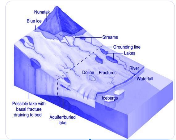
Which of the following statements best describes the term ‘Nunataks’?

Detailed Solution for Practice Test: Geography- 1 - Question 9

Nunataks: The higher peaks and mounds surrounded by ice from all sides are called nunataks. They look like scattered small islands amid extensive ice masses. That is why they are also called glacial islands. They decrease in size due to erosion caused by glacial lateral erosion and frost action.

Practice Test: Geography- 1 - Question 10

Consider the following pairs:

How many of the pairs given above are correct?

Detailed Solution for Practice Test: Geography- 1 - Question 10
  • Pair 1 is correct: Sital Sasthi is a sacred Hindu festival celebrated in Odisha. This week-long special festival highlights the marriage of Lord Shiva and Goddess Parvati. People observing this festival believe that Lord Shiva represents the scorching heat of summer while Goddess Parvati signifies the first rain. So, this holy and lavish wedding is observed for a good monsoon. Sital Sasthi is a celebration wherein Lord Shiva and Goddess Parvati are adopted by two families, and their wedding is solemnized with the involvement of rituals. After the marriage is performed, the God and Goddess are then carried around the city via a procession.
  • Pair 2 is correct: Bihu is the name for the National Festival of Assam which is one of the most beautiful states of India which is reckoned for tea gardens, mighty Brahmaputra River and Lush green forests. Also the state of Assam is reckoned for the Bihu festival that depicts a set of three different cultural festivals of the state. The origin of the term ‘Bihu’ came from the Sanskrit word that means ‘Vishu’. It is the cheerful festival of Assam that is celebrated by the locals irrespective of caste, creed and beliefs.
  • Pair 3 is incorrect: Pongal is a harvest festival celebrated by the Tamil community. It is a celebration to thank the Sun, Mother Nature and the various farm animals that help to contribute to a bountiful harvest. Celebrated over four days, Pongal also marks the beginning of the Tamil month called Thai, which is considered an auspicious month. It usually falls on the 14th or 15th of January each year.
Practice Test: Geography- 1 - Question 11

With reference to a Cyclone, consider the following statements:

1. The Indian subcontinent is exposed to nearly 45 percent of the world’s tropical cyclones.

2. The air circulates inward in an anticlockwise direction in the Northern hemisphere and clockwise in the Southern hemisphere in a cyclone.

3. Cyclones are classified on the basis of the wind speed and their capacity to cause damage.

Which of the statements given above are correct?

Detailed Solution for Practice Test: Geography- 1 - Question 11

Cyclones are classified as
(i) extratropical cyclones (also called temperate cyclones);
(ii) tropical cyclones.

  • Tropical cyclones are the progeny of ocean and atmosphere, powered by the heat from the sea; and driven by easterly trades and temperate westerlies, high planetary winds and their own fierce energy.
  • Tropical cyclones are large-scale weather systems developing over tropical or subtropical waters, where they get organised into surface wind circulation.
  • Extra tropical cyclones occur in temperate zones and high-latitude regions, though they are known to originate in the Polar Regions.

Statement 1 is incorrect: The Indian subcontinent is one of the worst affected regions in the world. The subcontinent, with a long coastline of 8041 kilometres, is exposed to nearly 10 per cent of the world’s tropical cyclones.

Statement 2 is correct: Cyclones are caused by atmospheric disturbances around a low-pressure area distinguished by swift and often destructive air circulation. Cyclones are usually accompanied by violent storms and bad weather. The air circulates inward in an anticlockwise direction in the Northern hemisphere and clockwise in the Southern hemisphere. Statement 3 is correct: In India, cyclones are classified by:

  • Strength of associated winds,
  • Storm surges
  • Exceptional rainfall occurrences

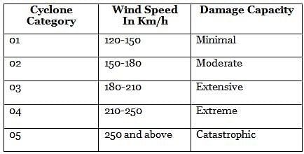
Cyclones are classified into five different levels on the basis of wind speed. They are further divided into the following categories according to their capacity to cause damage:-

Practice Test: Geography- 1 - Question 12

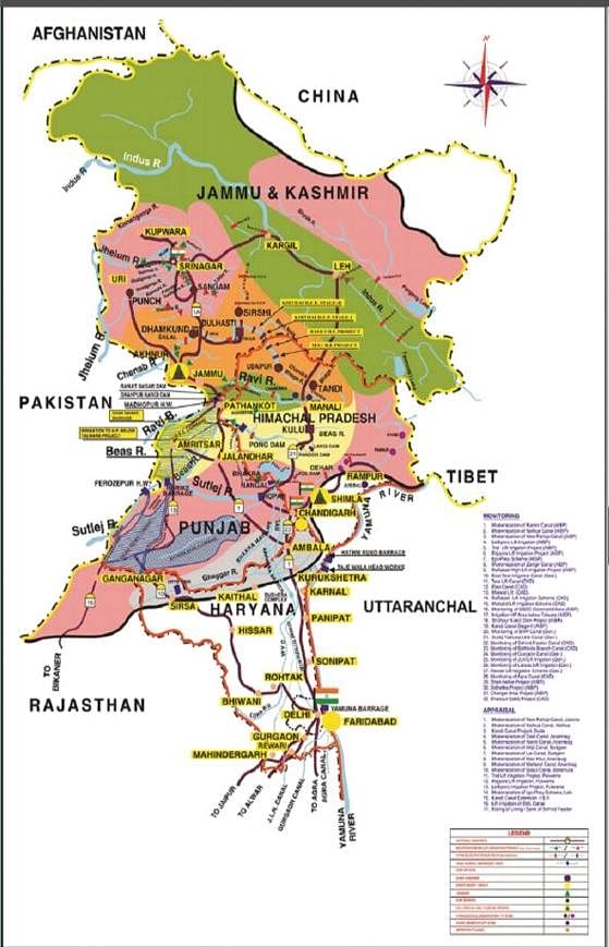
‘It drains the largest number of glaciers and mountain slopes of the Karakorum, Ladakh, Zaskar and Himalayan Ranges. Originating from the Kailash Mountain, it flows in a constricted valley north-westward through Tibet, where it is called Singi Khamban or Lion’s mouth.’

Which of the following rivers is best described in the passage given above?

Detailed Solution for Practice Test: Geography- 1 - Question 12

The Indus is the westernmost River system in the subcontinent. Jhelum, Chenab, Ravi, Beas and Satluj are its main tributaries. The Indus originates from the Bokhar Chu (glacier) on the northern slopes of Mt. Kailash (6714m). It drains the largest number of glaciers and mountain slopes of the Karakorum, Ladakh, Zaskar and Himalayan Ranges. Originating from the Kailash Mountain, it flows in a constricted valley northwestward through Tibet, where it is called Singi Khamban or Lion’s mouth. In Ladakh, it follows a long, nearly straight course between the Ladakh range and the Zaskar range. Downward; the Indus crosses the central Himalayan range through a huge synclinal gorge. The River passes by the Nanga-Parbat and turns southwest to enter Pakistan

Practice Test: Geography- 1 - Question 13

Consider the following statements:

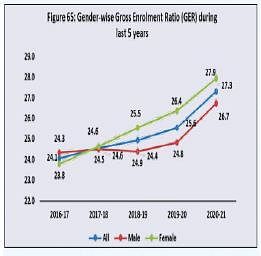
1. The Gross Enrolment Ratio for females in higher education has been consistently greater than that of males in the last 5 years.

2. The male-female gap in literacy rate in India has consistently reduced since Independence.

Which of the statements given above are correct?

Detailed Solution for Practice Test: Geography- 1 - Question 13

Gross Enrolment Ratio (GER) refers to the total enrolment in a specific level of education, regardless of age, expressed as a percentage of the eligible official schoolage population corresponding to the same level of education in a given school year. Table: Gender-wise GER figures of All India Survey on Higher Education (AISHE) and Literacy rate in India since independence

  • Statement 1 is correct: The Gross Enrolment Ratio for females in higher education has been consistently greater than that of males since 2017-18.

  • Statement 2 is incorrect: The malefemale gap in literacy rate in India has remained inconsistent since Independence.
Practice Test: Geography- 1 - Question 14

Consider the following statements in the context of Central Highlands:

1. The general slope of the highlands is towards the south and south-east.

2. Musi river basin forms the majority part of the region.

Which of the statements given above are correct?

Detailed Solution for Practice Test: Geography- 1 - Question 14

Statement 1 is incorrect. Central Highlands: also called the Madhya Bharat Pathar or Madhya Bharat Plateau. It slopes towards the north and northeastern directions. Musi River or Musinuru is a tributary of the Krishna River in the Deccan Plateau, flowing through Telangana state in India. Hyderabad stands on the banks of Musi river Hence, Statement 2 is incorrect.

Central Highlands are to the east of the Marwar or Mewar Upland and the north of the Narmada river. It covers the major portion of the Malwa plateau. Most of the plateau comprises the basin of the Chambal river which flows in a rift valley. The Kali Sindh, flowing from Rana Pratap Sagar, The Banas flowing through Mewar plateau, and The Parwan and the Parbati flowing from Madhya Pradesh are Chambal's main tributaries. It is a rolling plateau with rounded hills composed of sandstone. Thick forests grow here. To the north are the ravines or badlands of the Chambal river and Satpura ranges, to the south is the Deccan plateau, and to the west are Aravalli ranges

Practice Test: Geography- 1 - Question 15

Which of the following are the major features of the Shola forests of Southern India?

1. Stunted trees

2. Large leaves

3. Round and dense canopies

4. Changing colours of leaves

Select the correct answer using the code given below:

Detailed Solution for Practice Test: Geography- 1 - Question 15
  • The Shola forests of southern India are classified as „Southern Montane Wet Temperate Forest’. The Sholas are found in the upper reaches of the Nilgiris, Anamalais, Palni hills, Kalakadu, Mundanthurai and Kanyakumari in the states of Tamil Nadu and Kerala. These forests are found sheltered in valleys with sufficient moisture and proper drainage, at an altitude of more than 1,500 metres. The upper reaches are covered with grasslands, known as Shola grasslands.
  • The vegetation that grows in Shola forests is evergreen. The trees are stunted and have many branches. Their rounded and dense canopies appear in different colours. Generally, the leaves are small in size and leathery. Red-coloured young leaves turning into different colours on maturity is a prominent characteristic of the Shola forests. Epiphytes like lichens, ferns and bryophytes usually grow on the trees.
  • Sholas play a major role in conserving the water supply of the Nilgiris’ streams. Pastoral communities, who settled in the grasslands centuries ago, periodically burn grass. This has checked the advance of the Shola forests. As tree species of the montane, evergreen forests are flammable, regeneration of any Shola tree species is completely prevented except for Rhododendron nilagiricum, the only Shola tree that can tolerate fire.
Practice Test: Geography- 1 - Question 16

Consider the following statements:
1. During equinoxes, all parts of the worldhave equal days and nights.
2. Equinoxes occur during the months ofJune and December every year.
Which of the statements given above is/arecorrect?

Detailed Solution for Practice Test: Geography- 1 - Question 16
  • In the course of a year, the earth’s revolution round the sun with its axis inclined at 66 1/2 degrees to the plane of the ecliptic changes the apparent altitude of the midday sun. The sun is vertically overhead at the equator on two days each year. These are usually 21 March and 21 September though the date changes because a year is not exactly 365 days. Hence statement 2 is not correct.
  • These days are termed equinoxes meanings equal nights because, on these two days, all parts of the world have equal days and nights. Hence statement 1 is correct.
  • After the March equinox the sun appears to move north and is vertically overhead at the Tropic of Cancer (23 1/2 degrees N.) on about 21 June. This is known as the June or summer solstice, when the northern hemisphere will have its longest day and shortest night. Hence statement 2 is not correct.
  • By about 22 December, the sun will be overhead at the Tropic of Capricorn (23 1/2 degrees S.). This is the winter solstice when the southern hemisphere will have its longest day and shortest night. Hence statement 3 is correct.
  • The Tropics thus mark the limits of the overhead sun, for beyond these, the sun is never overhead at any time of the year. Such regions are marked by distinct seasonal changes spring, summer, autumn and winter. Beyond the Arctic Circle (66 1/2 degrees N.) and the Antarctic Circle (66 1/2 degrees S.) where darkness lasts for 6 months and daylight is continuous for the remaining half of the year, it is always cold; for even during the short summer the sun is never high in the sky.
  • Within the tropics, as the midday sun varies very little from its vertical position at noon daily, the four seasons are almost indistinguishable. Days and nights are almost equal all year round.
Practice Test: Geography- 1 - Question 17

Consider the following statements:

1. The Chenab flows through the Wular Lake before entering Pakistan through a deep narrow gorge.

2. The Indus rises west of the Rohtang Pass and flows through the Chamba valley.

3. The Satluj originates in Tibet, passes through the Shipki La and enters the Punjab plains.

Which of the statements given above are incorrect?

Detailed Solution for Practice Test: Geography- 1 - Question 17
  • Statement 1 is incorrect: Just before the Jhelum River enters the main city of Srinagar which is situated on its both banks it is joined near Shergari by a stream which drains from Dal Lake. At Banyari 20 km. downstream the River joins with the water of Wular Lakes and takes off from the lake at its southwest corner and flows to the southwest direction through the alluvial plain for a length of 21 km up to the bridge at Baramulla.
  • Statement 2 is incorrect: The Ravi is another important tributary of the Indus. It rises west of the Rohtang pass in the Kullu hills of Himachal Pradesh and flows through the Chamba valley of the state. Before entering Pakistan and joining the Chenab near Sarai Sidhu, it drains the area lying between the southeastern part of the Pir Panjal and the Dhauladhar ranges.
  • Statement 3 is correct: The Satluj originates in the „Raksas tal’ near Mansarovar at an altitude of 4,555 m in Tibet where it is known as Langchen Khambab. It flows almost parallel to the Indus for about 400 km before entering India, and comes out of a gorge at Rupar. It passes through the Shipki La on the Himalayan ranges and enters the Punjab plains. It is an antecedent river. It is a very important tributary as it feeds the canal system of the Bhakra Nangal project.
Practice Test: Geography- 1 - Question 18

Recently, the Ministry of Culture announceda year-long commemoration of the birthanniversary of Santh Sevalal Maharaj. He isa spiritual teacher/guru of which of thefollowing communities?

Detailed Solution for Practice Test: Geography- 1 - Question 18
  • For the first time ever, the Ministry of Culture has announced a year-long commemoration of the birth anniversary of Banjara Dharmaguru Santh Sevalal Maharaj.
    • Born in 1739 in Shivamogga district of Karnataka.
    • He was a social reformer and spiritual teacher of Banjara Community. Hence option (c) is the correct answer.
      • Spread across India, Banjara Community is a nomadic community with nearly 10-12 crore population. They are classified as SC, ST and OBC in different states.
      • Having sound knowledge in Ayurveda and Naturopathy, he eradicated myths and superstitions prevalent among forest dwellers and nomadic tribe.
Practice Test: Geography- 1 - Question 19

Consider the following statements:

1. Aesthetic forestry refers to the growth of forests without human intervention.

2. Unlike farm forestry, community forestry takes place on public land.

Which of the statements given above are correct?

Detailed Solution for Practice Test: Geography- 1 - Question 19
  • Statement 1 is incorrect: Aesthetic Forestry is the practice of forestry with the object of raising flowering trees and shrubs mainly to serve as recreation forests for the urban and rural population. This type of forestry is also known as Recreational forestry which is defined as the practice of forestry with the object of developing or maintaining a forest of high scenic value.
  • Statement 2 is correct: Farm Forestry is the name given to programmes which promote commercial tree growing by farmers on their own land. It is defined as the practice of forestry in all its aspects in and around the farms or village lands integrated with other farm operations. Community forestry involves the raising of trees on public or community land such as the village pasture and temple land, roadside, canal bank, strips along railway lines, and schools etc. Community forestry programme aims at providing benefits to the community as a whole. Community forestry provides a means under which the people of landless classes can associate themselves with tree raising and thus, get those benefits which otherwise are restricted for landowners.
Practice Test: Geography- 1 - Question 20

With reference to the distribution ofvolcanoes in the world, consider thefollowing statements:
1. Mt. Cameroon is an active volcano inEast African Rift Valley.
2. Mt. Kilimanjaro is an extinct volcano inWest Asia.
3. Most of the volcanic activities take placebelow the sea.
Which of the statements given above are notcorrect?

Detailed Solution for Practice Test: Geography- 1 - Question 20
  • Most known volcanic activity and earthquakes occur along converging plate margins and mid-oceanic ridges. Nearly 70 percent of earthquakes occur in the Circum-Pacific belt. Another 20 percent of earthquakes take place in the Mediterranean-Himalayan belt including Asia Minor, the Himalayas, and parts of north-west China.
  • Only 10 percent to 20 percent of all volcanic activity is above the sea, and terrestrial volcanic mountains are small when compared to their submarine counterparts. Hence statement 3 is correct.
  • The circum-Pacific region popularly termed the ‘Pacific Ring of Fire’, has the greatest concentration of active volcanoes. The volcanic belt and earthquake belt closely overlap along the ‘Pacific Ring of Fire’.
  • Mount Cameroon
    • It is an active volcano that is also known by many other names, and it is located near the Gulf of Guinea, within the Republic of Cameroon.
    • Mt. Cameroon is the highest peak in sub-Saharan western and central Africa and the westernmost extension of a series of hills and mountains that form a natural boundary between northern Cameroon and Nigeria. Hence statement 1 is not correct.
  • In Africa, some volcanoes are found along the East African Rift Valley, e.g. Mt. Kilimanjaro and Mt. Kenya. Hence statement 2 is not correct.
  • Mount Kilimanjaro
    • Located in Tanzania, Mount Kilimanjaro is Africa’s tallest mountain at about 5,895 meters (19,340 feet). It is the largest free-standing mountain rise in the world, meaning it is not part of a mountain range.
    • Also called a stratovolcano (a term for a very large volcano made of ash, lava, and rock), Kilimanjaro is made up of three cones: Kibo, Mawenzi, and Shira. Kibo is the summit of the mountain and the tallest of the three volcanic formations. While Mawenzi and Shira are extinct, Kibo is dormant and could possibly erupt again. Scientists estimate that the last time it erupted was 360,000 years ago.
  • Mediterranean volcanism
    • Volcanoes of the Mediterranean region are mainly associated with the Alpine folds, e.g. Vesuvius, Stromboli (Light House of the Mediterranean) and those of the Aegean islands. A few continue into Asia Minor (Mt. Ararat, Mt. Elbruz).
    • Mt. Stromboli is a small island in the Tyrrhenian Sea, off the north coast of Sicily, containing one of the three active volcanoes in Italy. It is one of the eight Aeolian Islands, a volcanic arc north of Sicily.
Practice Test: Geography- 1 - Question 21

 Consider the following pairs:

How many of the above pairs are correctly matched?

Detailed Solution for Practice Test: Geography- 1 - Question 21

A large dam is classified as one with a maximum height of more than 15 metres from its deepest foundation to the crest. A dam between 10 and 15 metres in height from its deepest foundation is also included in the classification of a large dam provided it complies with one of the following conditions :

  • length of the crest of the dam is not less than 500 metres or
  • capacity of the reservoir formed by the dam is not less than one million cubic metres or
  • the maximum flood discharge dealt with by the dam is not less than 2000 cubic metres per second or
  • the dam has especially difficult foundation problems, or
  • the dam is of unusual design

Pair 1 is correctly matched: Tehri Dam

  • River – Bhagirathi
  • State – Uttarakhand

Pair 2 is incorrectly matched: Nagarjuna Sagar Dam

  • River – Krishna
  • State – Telangana

Pair 3 is incorrectly matched: Idukki Dam

  • River – Periyar
  • State – Kerala

Pair 4 is correctly matched: Ranjit Sagar Dam

  • River – Ravi
  • State – Punjab
Practice Test: Geography- 1 - Question 22

In the context of the Indian Monsoon, whichof the following best describes the reason forthe break in monsoon over northern India?

Detailed Solution for Practice Test: Geography- 1 - Question 22

During the southwest monsoon period after having rained for a few days, if rain fails to occur for one or more weeks, it is known as a break in the monsoon. These dry spells are quite common during the rainy season. These breaks in the different regions are due to different reasons:

  • In northern India, rains are likely to fail if the rain-bearing storms are not very frequent along the monsoon trough or the ITCZ over this region.
  • Over the west coast, the dry spells are associated with days when winds blow parallel to the coast.

Hence option (a) is the correct answer.

Practice Test: Geography- 1 - Question 23

With reference to the measurement ofearthquakes, consider the following statements:
1. The Richter scale is a magnitude scalecalculated by the logarithm of theamplitude of waves.
2. The Mercalli scale is an intensity scaleused to quantify the effect of anearthquake on human life.
Which of the statements given above is/arecorrect?

Detailed Solution for Practice Test: Geography- 1 - Question 23
  • Measurement of Earthquakes is done according to the magnitude or intensity of the shock.
  • Magnitude Scale:
    • Magnitude is the amount of energy released and is based on the direct measurement of the size of seismic waves. The magnitude scale is known as the Richter Scale. Hence statement 1 is correct.
    • The Richter magnitude scale was developed in 1935 by Charles F. Richter as a mathematical device to compare the size of earthquakes. The magnitude of an earthquake is determined from the logarithm of the amplitude of waves recorded by seismographs.
    • Because of the logarithmic basis of the scale, each whole number increase in magnitude represents a ten-fold increase in measured amplitude; as an estimate of energy, each whole number step in the magnitude scale corresponds to the release of about 31 times more energy than the amount associated with the preceding whole number value.
  • Intensity Scale:
    • The intensity of an earthquake is measured in terms of its effects on human life. The intensity of an earthquake at a specific location depends on a number of factors the total amount of energy released, the distance from the epicenter, the types of rocks, and the degree of consolidation.
    • The Mercalli intensity scale is a scale used for measuring the intensity of an earthquake. The scale quantifies the effects of an earthquake on the Earth's surface, humans, objects of nature, and man-made structures on a scale of I through XII, with I denoting ‘not felt’, and XII ‘total destruction’. Hence statement 2 is correct.
    • Data is gathered from individuals who have experienced the quake, and an intensity value will be given to their location.
Practice Test: Geography- 1 - Question 24

Consider the following statements with reference to the British type of climate:

1. The natural vegetation of the British type of climate is temperate evergreen forest.

2. The natural vegetation of the British-type of climate is not suitable for the lumbering industry.

Which of the statements given above are correct?

Detailed Solution for Practice Test: Geography- 1 - Question 24
  • Statement 1 is incorrect: The natural vegetation of the British type of climate is deciduous forest. The trees shed their leaves in the cold season. This is an adaptation for protecting themselves against the winter snow and frost. Shedding begins in autumn, during which the leaves fall and are scattered by the winds. When the deciduous trees have leaves, they have thick trunks and outspreading branches that yield valuable temperate hardwood. Some of the more common species include oak, elm, ash, birch and poplar. In the wetter areas grow willows, alder and aspen.
  • Statement 2 is incorrect: Unlike the equatorial forests, the deciduous trees in the British climate occur in pure stands and have greater lumbering value from the commercial point of view. The open nature of the forests with spare undergrowth is useful in logging operations. Easy penetration helps in the movement of the logs and can save much of the cost.
Practice Test: Geography- 1 - Question 25

Consider the following statements regarding the distribution and direction of monsoon rainfall across India:
1. Rainfall in the western Himalayas is often caused by the joining of the Arabin Sea branch and the Bay of Bengal Branch.
2. Arakan valley has a significant role indirecting the Bay of Bengal branch towards the Indian sub-continent.
Which of the statements given above is/are correct?

Detailed Solution for Practice Test: Geography- 1 - Question 25
  • As the monsoon winds approach the Indian subcontinent, their southwesterly direction is modified by the relief and thermal low pressure over northwest India. The monsoon approaches the landmass in two branches: the Arabian Sea branch and the Bay of Bengal branch.
  • The monsoon winds originating over the Arabian Sea splits into three branches.
    • Its one branch is obstructed by the Western Ghats. They bring heavy rainfall in the windward side of the Sahyadris and western coastal plains.
    • Another branch of the Arabian sea monsoon strikes the coast north of Mumbai. Moving along the Narmada and Tapi river valleys, these winds cause rainfall in extensive areas of central India.
    • A third branch of this monsoon wind strikes the Saurashtra Peninsula and the Kachchh. It then passes over west Rajasthan and along the Aravalis, causing only a scanty rainfall. In Punjab and Haryana, it too joins the Bay of Bengal branch. These two branches, reinforced by each other, cause rains in the western Himalayas. Hence, statement 1 is correct.
  • The Bay of Bengal branch strikes the coast of Myanmar and part of southeast Bangladesh. But the Arakan Hills along the coast of Myanmar deflect a big portion of this branch toward the Indian subcontinent. The monsoon, therefore, enters West Bengal and Bangladesh from the south and southeast instead of from the south-westerly direction. Hence, statement 2 is correct.
Practice Test: Geography- 1 - Question 26

Which of the following aquifer systems covers the maximum area of India?

Detailed Solution for Practice Test: Geography- 1 - Question 26

The entire country has been classified into 14 Principal Aquifer Systems and 42 major aquifers based on the hydrogeological characteristics.

  • Alluviums cover a maximum area of around 31% of the entire country and are available in Uttar Pradesh, Bihar, West Bengal, Assam, Odisha and Rajasthan.
  • Around 20% of the area of the country is covered by the Banded Gneissic Complex (BGC) and Gneiss aquifers which are available almost in all the peninsular states as well as the Himalayan states.
  • Basalt aquifer covers around 17% area of the country and is mainly spread over Maharashtra, Madhya Pradesh, Gujarat, Rajasthan and Karnataka.
  • Sandstone aquifer covers around 8% area in the country and is available in Chhattisgarh, Andhra Pradesh, Madhya Pradesh, Gujarat, Karnataka and Rajasthan.
  • Shale aquifer accounts for around 7% of the area.
  • Limestone aquifer covers a very small area of around 2% in the country.
  • The rest 15% of the entire area is covered by aquifers namely; Schist, Granite, Quartzite, Charnockite, Khondalite, Laterites and Intrusive.
Practice Test: Geography- 1 - Question 27

Which of the following commonly found plants in India have medicinal properties?
1. Sarpagandha
2. Babool
3. Arjun
4. Kachnar
Select the correct answer using the code given below.

Detailed Solution for Practice Test: Geography- 1 - Question 27
  • India is known for its herbs and spices from ancient times. Some 2,000 plants have been described in Ayurveda and at least 500 are in regular use. The World Conservation Union’s Red List has named 352 medicinal plants of which 52 are critically threatened and 49 endangered. The commonly used plants in India are:
    • Sarpagandha: Used to treat blood pressure; it is found only in India.
    • Jamun: The juice from ripe fruit is used to prepare vinegar, which is carminative and diuretic, and has digestive properties. The powder of the seed is used for controlling diabetes.
    • Arjun: The fresh juice of leaves is a cure for earache. It is also used to regulate blood pressure.
    • Babool: Leaves are used as a cure for eye sores. Its gum is used as a tonic.
    • Neem: Has high antibiotic and antibacterial properties.
    • Tulsi: Is used to cure cough and cold.
    • Kachnar: It is used to cure asthma and ulcers. The buds and roots are good for digestive problems.
  • Hence, option (d) is the correct answer.
Practice Test: Geography- 1 - Question 28

Which of the following traditional water harvesting methods uses ‘kuis’ or ‘beris’ to access percolated rainwater in sandy soil?

Detailed Solution for Practice Test: Geography- 1 - Question 28

Paar is a common water harvesting practice in the western Rajasthan region. It is a common place where the rainwater flows from the agar (catchment) and in the process percolates into the sandy soil. To access the Rajani pani (percolated water) kuis or beris are dug in the agor (storage area). Kuis or beris are normally 5 metres (m) to 12 m deep. The structure was constructed through traditional masonry technology.

  • Talab/Bandhis: Reservoirs, natural or human-made, are called talabs. They play a crucial role in irrigation and drinking purposes, with smaller ones referred to as talai and medium-sized lakes as bandhi or talab.
  • Saza Kuva: An open well with multiple owners, Saza Kuva is a vital source of irrigation in the Aravalli hills, employing traditional water-lifting devices and buffalo-powered mechanisms.
  • Johad: Small earthen check dams, known as johads, capture and conserve rainwater, leading to significant improvements in percolation and groundwater recharge in regions like Alwar district, Rajasthan.
  • Pat: The unique pat system in Bhitada village, Madhya Pradesh, involves diverting water from hill streams into irrigation channels called pats, requiring constant maintenance and collaborative efforts from the community.
Practice Test: Geography- 1 - Question 29

Consider the following mountain ranges in India:
1. Satpura Range
2. Shiwalik Range
3. Vindhya Range
What is the order of the above ranges from North to South direction?

Detailed Solution for Practice Test: Geography- 1 - Question 29
  • Siwalik Range, also called Siwalik Hills or Outer Himalayas, Siwalik also spelled Shiwalik, is the subHimalayan range of the northern Indian subcontinent. It extends west-northwestward for more than 1,000 miles (1,600 km) from the Tista River in Sikkim state, northeastern India, through Nepal, across northwestern India, and into northern Pakistan. Though only 10 miles (16 km) wide in places, the range has an average elevation of 3,000 to 4,000 feet (900 to 1,200 meters). It rises abruptly from the plain of the Indus and Ganges (Ganga) rivers (south) and parallels the main range of the Himalayas (north), from which it is separated by valleys. The Siwaliks are sometimes considered to include the southern foothills of the Assam Himalayas, which extend eastward for 400 miles (640 km) across southern Bhutan to the bend of the Brahmaputra River. The range proper, to which the name Siwalik (from Sanskrit, meaning “Belonging to [the God] Shiva”) was formerly restricted, is the 200 miles (320 km) of foothills in India extending from the Ganges River at Haridwar, Uttarakhand state, northwestward to the Beas River.
  • Vindhya Range is a broken range of hills forming the southern escarpment of the central upland of India. From Gujarat state on the west, it extends about 675 miles (1,086 km) across Madhya Pradesh state to abut on the Ganges (Ganga) River valley near Varanasi, Uttar Pradesh. The mountains form the southern edge of the Malwa Plateau and then divide into two branches: the Kaimur Range, running north of the Son River into western Bihar state, and the southern branch, running between the upper reaches of the Son and Narmada rivers to meet the Satpura Range in the Maikala Range (or Amarkantak Plateau).
  • The Satpura Range is formed by a series of scarped plateaus on the south, generally at an elevation varying between 600-900 m above the mean sea level. This forms the northernmost boundary of the Deccan plateau. It is a classic example of the relict mountains which are highly denuded and form discontinuous ranges.

Practice Test: Geography- 1 - Question 30

Consider the following pairs:

How many of the above pairs are correctly matched?

Detailed Solution for Practice Test: Geography- 1 - Question 30

Jhumming: The ‘slash and burn’ agriculture is known as ‘Milpa’ in Mexico and Central America, ‘Conuco’ in Venezuela, ‘Roca’ in Brazil, ‘Masole’ in Central Africa, ‘Ladang’ in Indonesia, ‘Ray’ in Vietnam. In India, this primitive form of cultivation is called

  • 'Bewar’ or 'Dahiya’ in Madhya Pradesh,
  • 'Podu’ or „Penda’ in Andhra Pradesh,
  • 'Pama Dabi’ or „Koman’ or Bringa’ in Odisha,
  • ‘Kumari’ in Western Ghats,
  • ‘Valre’ or ‘Waltre’ in Southeastern Rajasthan,
  • ‘Khil’ in the Himalayan belt, 
  • 'Kuruwa’ in Jharkhand, and
  • ‘Jhumming’ in the North-eastern region.
View more questions
Information about Practice Test: Geography- 1 Page
In this test you can find the Exam questions for Practice Test: Geography- 1 solved & explained in the simplest way possible. Besides giving Questions and answers for Practice Test: Geography- 1, EduRev gives you an ample number of Online tests for practice
Download as PDF