UPSC Exam  >  UPSC Tests  >  Practice Test: Geography- 2 - UPSC MCQ

Practice Test: Geography- 2 - UPSC MCQ


Test Description

30 Questions MCQ Test - Practice Test: Geography- 2

Practice Test: Geography- 2 for UPSC 2024 is part of UPSC preparation. The Practice Test: Geography- 2 questions and answers have been prepared according to the UPSC exam syllabus.The Practice Test: Geography- 2 MCQs are made for UPSC 2024 Exam. Find important definitions, questions, notes, meanings, examples, exercises, MCQs and online tests for Practice Test: Geography- 2 below.
Solutions of Practice Test: Geography- 2 questions in English are available as part of our course for UPSC & Practice Test: Geography- 2 solutions in Hindi for UPSC course. Download more important topics, notes, lectures and mock test series for UPSC Exam by signing up for free. Attempt Practice Test: Geography- 2 | 50 questions in 60 minutes | Mock test for UPSC preparation | Free important questions MCQ to study for UPSC Exam | Download free PDF with solutions
Practice Test: Geography- 2 - Question 1

Which of the following best describes the term "truck farming"?

Detailed Solution for Practice Test: Geography- 2 - Question 1
  • "Truck farming" refers to the highly specialised and intensive form of market gardening practised in North-West Europe, particularly in areas like the Vales of York and Evesham in the United Kingdom. These farms, characterized by small size and proximity to urban or industrial centres, focus on cultivating perishable crops such as lettuces, cabbages, tomatoes, and fruits.
  • The term, Truck farming is commonly used in the United States to describe this practice, emphasizing the efficient transport of fresh produce to meet the demands of urban populations.
Practice Test: Geography- 2 - Question 2

The nomadic tribes named the Lapps, the Yakuts, and the Samoyeds belong to which of the following regions?

Detailed Solution for Practice Test: Geography- 2 - Question 2
  • In the Eurasian tundra, are nomadic tribes such as the Lapps of northern Finland and Scandinavia, the Samoyeds of Siberia (from the Ural Mountains and the Yenisey basin), the Yakuts from the Lena basin, and the Koryaks and Chuckchi of north-eastern Asia. They wander with their herds of reindeer across the Eurasian tundra where there are pastures. Many of them have taken to a more settled life. In the erstwhile U.S.S.R. large farms have been established for raising reindeer and for breeding furbearing animals.
  • Tundra, a major zone of treeless level or rolling ground found in cold regions, mostly north of the Arctic Circle (Arctic tundra) or above the timberline on high mountains (alpine tundra). Tundra is known for large stretches of bare ground and rock and for patchy mantles of low vegetation such as mosses, lichens, herbs, and small shrubs.
1 Crore+ students have signed up on EduRev. Have you? Download the App
Practice Test: Geography- 2 - Question 3

Consider the following :

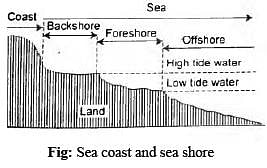
  1. The back shore represents the beach zone, starting from the limit of frequent storm waves to the cliff base.
  2. Foreshore extends from low tide water to high tide water.
  3. Offshore represents the zone of shallow bottom of the continental slope.

How many of the above given statements are correct regarding the sea coast and the seashore?

Detailed Solution for Practice Test: Geography- 2 - Question 3

Generally, sea coast and seashore are taken as synonyms, but geomorphologically these two terms have quite different meanings. Sea shore represents the zone of land between high tide water (HTW ) and low tide water (LTW) while the shoreline represents the actual landward lim it of seawater at a given moment of time. ‘The shoreline is the line of demarcation between land and water. It fluctuates from moment to moment influenced by waves and tides’ (A. Bloom, 1979). The coast represents the land-zone immediately behind the cliff. The coastline represents the cliffline or the margin of land rising above the sea water. The shore zone or simply shore is divided into 3 zones :

  • Back shore represents the beach zone starting from the limit of frequent storm waves to the cliff base.Hence,Statement 1 is correct
  • Foreshore extends from low tide w ater to high tide water.Hence,Statement 2 is correct
  • Offshore represents the zone of shallow bottom of the continental slope.Hence,Statement 3 is correct

Practice Test: Geography- 2 - Question 4

With reference to the ‘erosional processes’, consider the following statements:

  1. Hydraulic action is the mechanical loosening and removal of materials of rocks by water alone without the help of erosion tools.
  2. Attrition is the process of removing, lifting and blowing away dry and loose particles of sand and dust by winds.
  3. Deflation refers to the wearing down and rounding of sediment particles as they collide with each other during transport.

Which of the statements given above are correct?

Detailed Solution for Practice Test: Geography- 2 - Question 4

Erosion is the acquisition and transportation of rock debris by geomorphic agents like running water, the wind, waves, glaciers, etc. Though weathering aids erosion, it is not a precondition for erosion to take place. (i.e., erosion can take place in unweathered conditions also).

  • Statement 1 is correct: The breakdown of rocks due to pressure exerted by water currents of the rivers and sea waves is termed Hydraulic action. It is the mechanical loosening and removal of materials of rocks by water alone without the help of erosion tools. The rivers erode their valley walls through hydraulic action.
  • Statement 2 is incorrect: Attrition refers to mechanical tear and wear of erosion tools suffered by themselves. The boulders, cobbles, pebbles, etc, while moving downstream with water, collide against each other and thus are fragmented into smaller and finer pieces in transit.
    Attrition by wind involves the mechanical breakdown of rock particles while they are transported by wind through the processes of saltation and surface creep.
  • Statement 3 is incorrect: Deflation is the process of removing, lifting and blowing away dry and loose particles of sand and dust by winds. It happens in semi-arid or arid regions. Congelifraction (frost weathering), Congelifluction (soil creep), nivation (snow patch erosion), etc. are significant weathering and transportation mechanisms performed by periglacial agents.
Practice Test: Geography- 2 - Question 5

Consider the Following:

  1. Gorges
  2. Plunge Pools
  3. Rapids
  4. Crevasses

How many of the above are erosional landforms formed by the running water?

Detailed Solution for Practice Test: Geography- 2 - Question 5
  • Hard and resistant bedrock hinder the widening of the valley at the top but down cutting process continues with the vigour of the river which can lead to the formation of gorge. The narrow and very deep gorge or the canyon with vertical walls is also known as the ‘I’ shaped valley. Hence, option 1 is correct.
  • The Plunge Pool is formed on the river bed mostly because of hydraulic action where the water falls from height and causes bedrock erosion. Hence, option 2 is correct.
  • Rapids formed in areas of shallow fastflowing water in younger streams. There are many tiny waterfalls created within the stream. Hence, option 3 is correct.
  • Crevasses: These are cracks which appear on the top of the glaciers and headwalls of cirques. Hence, option 4 is incorrect.
Practice Test: Geography- 2 - Question 6

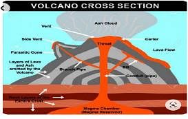
Consider the following statements about Volcanoes:

  1. Magma once it starts moving towards the crust or it reaches the surface, is referred to as lava.
  2. The Hawaiian volcanoes are famous examples of shield volcanoes.

Which of the statements given above are incorrect?

Detailed Solution for Practice Test: Geography- 2 - Question 6
  • A volcano is a place where gases, ashes and/or molten rock material – lava – escape to the ground. A volcano is called an active volcano if the materials mentioned are being released or have been released in the recent past.
  • Statement 1 is correct: The mantle contains a weaker zone called the asthenosphere. From this, the molten rock materials find their way to the surface. The material in the upper mantle portion is called magma. Once it starts moving towards the crust or reaches the surface, it is called lava. The material that reaches the ground includes lava flows, pyroclastic debris, volcanic bombs, ash and dust and gases such as nitrogen compounds, sulphur compounds and minor amounts of chlorine, hydrogen and argon.
  • Statement 2 is correct: Barring the basalt flows, the shield volcanoes are the largest of all the volcanoes on the Earth. The Hawaiian volcanoes are the most famous examples. These volcanoes are mostly made up of basalt, a type of lava that is very fluid when erupted. For this reason, these volcanoes are not steep. They become explosive if somehow water gets into the vent; otherwise, they are characterised by low explosivity.

Practice Test: Geography- 2 - Question 7

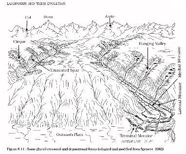
Which of the following are examples of Erosional landforms of Glaciation?

  1. Eskers
  2. Aretes
  3. Bergschrund
  4. Moraines
  5. Drumlins

Select the correct answer using the code given below:

Detailed Solution for Practice Test: Geography- 2 - Question 7

Erosional Landforms: The erosional work of the glaciers is accomplished through the mechanisms of abrasion,plucking and polishing. Pure ice mass is geomorpho logically inactive but when coarse debris is carried by the glacier at its base it becomes an active agent of erosion. Thus, the glacier erodes its bed and sidewalls with the help of tools of erosion (coarse debris) through the mechanism of abrasion. Large particles of well jointed rocks are detached by the moving glacial ice. This mechanism is called plucking.

  • Aretes: The mountain divide is sharpened due to recession of cirques on its both sides. Such sharpened peaks resembling sawteeths are called aretes. An arete is, in fact, a saw-toothed divide consisting of a series of close and intervening ridge segments.
  • Bergschrund: At the head of a glacier, where it begins to leave the snowfield of a Corrie, a deep vertical crack opens called a Bergschrund(in German) or Rimaye(in French). This happens in summer when, although the ice continues to move out of the Corrie, there is no new snow to replace it. The Bergschrund is a major obstacle to climbers.
  • Other kinds of erosional landforms are Cirque, Corrie, U-shaped glacial trough, Hanging Valley, Nunatak.

Practice Test: Geography- 2 - Question 8

Consider the following statements:

  1. Straight Channels are found where there is the same structure and parallel disposition of hard and soft rocks on the underlying topography.
  2. A Meandering Channel shows both the erosion as well as deposition features.
  3. A Braided Channel is formed when a stream contains too much sediment, and the stream divides into branching and intertwining subchannels.

Which of the statements given above are correct?

Detailed Solution for Practice Test: Geography- 2 - Question 8
  • Statement 1 is correct: Straight Channels are rare and usually found where there is the same structure and parallel disposition of hard and soft rocks on the underlying topography, which forces the channel to be straight. When the velocity of the stream is low, the sediment can be deposited to form a point bar.
  • Statement 2 is correct: A Meandering Channel is the characteristic of a river that is free to travel across a valley floor. They develop most readily on low gradient slopes composed of easily eroded sediments. Rivers in mature stages often show such sinuous channels, of which the outer curve is important due to relatively free water flow, and the inner side, due to restricted flow, sheds off some of its load, called slip-off slope. When you have a look at the transverse section, it will show a sloping surface from the cut-off to the slipoff side. Hence, one can observe both erosion and deposition in the case of meandering rivers.
  • Statement 3 is correct: A Braided Channel is formed when a stream contains more sediment than it can readily transport. It is the stream that divides into branching and intertwining subchannels separated by islands or sandbars. It is also characteristic of the mature stage of river development.
Practice Test: Geography- 2 - Question 9

“The heavy rainfall, the warm summers and the damp air from fogs, all favour the growth of trees. Forests are adaptable to cold conditions. The trees occur in almost pure stands and timber is a leading export item of this region. A long growing season of over six months and an adequate supply of moisture from maritime sources encourage rapid growth of ferns.”
Which of the following climatic types is best described by the passage above?

Detailed Solution for Practice Test: Geography- 2 - Question 9
  • The predominant vegetation of the Laurentian type of climate is cool temperate forest. The heavy rainfall, the warm summers and the damp air from fogs, all favour the growth of trees. Generally speaking, the forest tend to be coniferous north of the 50°N. parallel of latitude. The increase in the length and severity of the Winter excludes forests that are not adaptable to cold conditions. In the Asiatic region (eastern Siberia and Korea), the coniferous forests are, in fact, a continuation of the great coniferous belt of the taiga. Lumbering has always been a major occupation of this sparsely populated part of eastern Asia and timber is a leading export item. Much of the original coniferous forests of fir, spruce and larch have been cleared as a result of lumbering rather than agriculture.
  • South of latitude 50°N., the coniferous forests give way to deciduous forests. Oak, beech, maple and birch are the principal trees. Like their counterparts on the western margins, the deciduous forests are fairly open. A long growing season of over six months and an adequate supply of moisture from maritime sources encourage rapid growth of ferns and other temperate undergrowth. The occurrence of trees in almost pure stands, and the predominance of only a handful of species greatly enhance the commercial value of these forests. As a result, they have been extensively felled for the extraction of temperate hardwood.
Practice Test: Geography- 2 - Question 10

Consider the following pairs:
Geographical feature : Associated River

  1. Gandikota Canyon : Kaveri
  2. Gangani : Shilabati
  3. Raneh Fall : Betwa
  4. Vazhachal Falls : Bharathappuzha

How many of the above pairs are incorrectly matched? 

Detailed Solution for Practice Test: Geography- 2 - Question 10
  • Pair 1 is incorrect: Gandikota village is located in Kadapa district of the state of Andhra Pradesh, India and is home to a stunning canyon, by the Pennar river. Also called Gandikota Canyon, this natural structure is often compared to the Grand Canyon of Arizona, USA.
  • Pair 2 is correct: Gangani, widely known as the “Grand Canyon of Bengal” is a famous tourist & picnic spot situated by the town of Garhbeta of Paschim Medinipur district at a distance of 55 Km from Midnapore Town. It comprises natural hills around the River Shilabati, locally known as “Shilai River.”
  • Pair 3 is incorrect: The Raneh Fall is a natural waterfall on the Ken River, located in Khajuraho in the Indian state of Madhya Pradesh. The Ken River forms a 5 kilometres (3.1 mi) long, and 30 metres (98 ft) deep canyon made of pure crystalline granite in varying shades of colours ranging from pink and red to grey. There is a series of waterfalls in the canyon.
  • Pair 4 is incorrect: One of the most famous waterfalls of Kerala, Vazhachal Falls is situated on the Chalakudy River. The river originates in the upper reaches of the Western Ghats and the waterfall marks the start of the Sholayar range. The 120 m, almost 390 ft waterfall is a blessed sight.
Practice Test: Geography- 2 - Question 11

“Winters are long and very severe; summers are cool and brief. In some areas of this climate, there are weeks of continuous darkness.”
Which one of the following climatic regions is best described by the above paragraph?

Detailed Solution for Practice Test: Geography- 2 - Question 11
  • The polar type of climate and vegetation is found mainly north of the Arctic Circle in the northern hemisphere. The ice caps are confined to Greenland and to the highlands of these high-latitude regions, where the ground is permanently snowcovered. The lowlands, with a few months ice-free, have tundra vegetation.
  • In the southern hemisphere, the virtually uninhabited continent of Antarctica is the greatest single stretch of icecap where the layers of permanent ice are as thick as 10,000 feet.
  • The polar climate is characterized by a very low mean annual temperature and its warmest month is June (in Northern hemisphere). Normally not more than four months have temperatures above freezingpoint.
  • Winters are long and very severe; summers are cool and brief. Within the Arctic and Antarctic Circles, there are weeks of continuous darkness. At the North Pole, there are six months without light in winter. Despite the long duration of sunshine in summer, when the sun does not set, temperatures remain low because the sun is low in the sky and much of the warmth of its faint rays is either reflected by the ground snow, or used up in melting the ice. It has little power left to raise the air temperature.
  • Water in the soil is frozen to great depths and the summer heat can only thaw the upper six inches of the soil.
  • The ground remains solidly frozen for all but four months, inaccessible to plants. Frost occurs at any time and blizzards, reaching a velocity of 130 miles an hour are not infrequent. They can be very hazardous for the polar inhabitants.
  • In coastal districts, where warmer water meets cold land thick fogs may develop. They last for days, and in many instances it is not possible to see for more than a few feet.
Practice Test: Geography- 2 - Question 12

Which of the following statements about types of lava are correct?

  1. Basic lavas are rich in Iron and Magnesium but poor in Silica.
  2. Basic lavas flow quietly and are not very explosive.
  3. Acidic lava is highly fluid and affects extensive areas.

Select the correct answer using the code given below:

Detailed Solution for Practice Test: Geography- 2 - Question 12

There are two main types of lava:
Basic lavas and
Acidic lavas

  • Statement 1 is correct: Basic lava is the hottest lava about 1000°C and highly fluid. They are dark-coloured like basalt, rich in iron and magnesium but poor in silica.
  • Statement 2 is correct: When basic lava is poured out of the volcano, it flows quietly and is not very explosive. Due to their high fluidity, they flow readily with a speed of 10 to 30 miles per hour. They affect extensive areas, spreading out as thin sheets over great distances before they solidify. The resultant volcano is gently sloping with a wide diameter and forms a flattened shield or dome.
  • Statement 3 is incorrect: Acidic lava is highly viscous with a high melting point. They are light coloured of low density, and have a high percentage of silica. They flow slowly and seldom travel far before solidifying. The resultant cone is therefore steep-sided. The rapid congealing of lava in the vent obstructs the flow of the outpouring lava, resulting in loud explosions, and throwing out many volcanic bombs or pyroclasts. Sometimes the lavas are so viscous that they form a spine or plug at the crater like that of Mt.Pelee in Martinique.

Some spines are very resistant and while most of the material of very old volcanoes is removed by erosion, the spine may remain.

Practice Test: Geography- 2 - Question 13

Consider the following statements:
Statement-I: There are no big trees in the tundra region.
Statement-II:The tundra region is deficient in heat.
Which of the following is correct in respect of the above statements? 

Detailed Solution for Practice Test: Geography- 2 - Question 13
  • In an adverse environment such as the tundra, few plants survive. The greatest inhibiting factor is the region's deficiency in heat. With a growing season of less than three months and the warmest month not exceeding 50°F. (the tree-survival line), there are no trees in the tundra. Such an environment can support only the lowest form of vegetation, mosses, lichens and sedges.
  • Drainage in the tundra is usually poor as the subsoil is permanently frozen. Ponds, marshes and waterlogged areas are found in hollows.
  • In the more sheltered spots, stunted birches, dwarf willows and undersized alders struggle for a meagre existence.
  • Climatic conditions along the coastal lowlands are a little more favourable. Here are some hardy grasses and reindeer moss, which provide the only pasturage for the herbivorous animals like reindeer.
Practice Test: Geography- 2 - Question 14

Consider the following pairs:
River course : Landforms

  1. Upper : V shaped Valleys
  2. Middle : Estuaries
  3. Lower : Ox-bow lakes

How many of the above pairs are correctly matched?

Detailed Solution for Practice Test: Geography- 2 - Question 14

The course of a river is divided into three sections:

  1. The upper course or the stage of youth
  2. The middle course or the stage of maturity
  3. The lower course or the stage of old age.
  • Pair 1 is correct: The upper or mountain course begins from the source of the river in hilly or mountainous areas. The weathered rock material is carried into the stream partly through the action of gravity and partly by rainwater flowing into the river. Weathering helps in widening a valley at the top, giving it a typical ‘V’ shaped cross-section. Such valleys are known as ‘V’ shaped valleys.
  • Pair 2 is incorrect: In the middle course, even minor obstacles force a river to swing in loops to go round the obstacles. These loops are called meanders. Some of the land features formed by a river in its middle course are alluvial fans, and meanders.
  • Pair 3 is correct: The river moving downstream across a broad, level plain is heavy with debris brought down from the upper and middle courses. Vertical corrasion has almost ceased, the lateral corrasion still goes on to erode its banks further. The work of the river is mainly deposition, building up its bed and forming an extensive floodplain. In the lower course land features produced by river are meanders, flood plains, braided steam, oxbow lakes, deltas and estuaries.
Practice Test: Geography- 2 - Question 15

Consider the following:

  1. Lapilli
  2. Volcanic dust
  3. Volcanic bombs
  4. Volcanic ash

Which of the following is the correct ascending order of the size of the given pyroclastic materials? 

Detailed Solution for Practice Test: Geography- 2 - Question 15

Pyroclastic materials thrown during the explosive type of eruption are grouped into three categories,
(i) Essential materials include consolidated forms of live lavas. These are also known as tephra, which means ash. Essential materials are unconsolidated, and their size is up to 2 mm.
(ii) Accessory materials are formed of dead lavas,
(iii) Accidental materials include fragmental materials of crustal rocks.
On the basis of size, pyroclastic materials are grouped into
(i) volcanic dust (finest particles),
(ii) volcanic ash (2 mm in size),
(iii) lapilli (of the size of peas) and
(iv) volcanic bombs (6 cm or more in size),
which are of different shapes viz. ellipsoidal, discoidal, cuboidal, and irregularly rounded. The dimension of average volcanic bombs ranges from the size of a baseball or basketball to a giant size. Sometimes, the volcanic bombs weigh 100 tonnes in weight and are thrown up to a distance of 10 km.

Practice Test: Geography- 2 - Question 16

With reference to nutrient content, which one of the following correctly describes the alluvial soils?

Detailed Solution for Practice Test: Geography- 2 - Question 16
  • Alluvial soil is a type of soil that is formed by the deposition of sediments carried by rivers, streams, and other water bodies. It is one of the most fertile and agriculturally productive soil types found in various parts of the world.
  • Rich in potash (potassium): Alluvial soils are generally abundant in potash, which is beneficial for plant growth. Potassium is an essential nutrient for various physiological processes in plants, including enzyme activation, water uptake, and photosynthesis.
  • Poor in phosphorus: Alluvial soils are relatively deficient in phosphorus. Phosphorus is crucial for plant energy transfer, root development, and flowering, but its concentration in alluvial soils is often lower compared to other nutrients.
Practice Test: Geography- 2 - Question 17

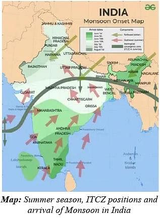
Consider the following statements regarding the summer weather patterns in the Indian subcontinent:

  1. The Inter Tropical Convergence Zone (ITCZ) shifts southward during the summer season.
  2. Westerly jet stream over the North Indian Plain strengthens as the summer progresses.

Which of the statements given above are correct?

Detailed Solution for Practice Test: Geography- 2 - Question 17
  • Statement 1 is incorrect: As the summer sets in and the sun shifts northwards (apparent motion), the wind circulation over the subcontinent undergoes a change at both, the lower as well as the upper levels. By the middle of July, the low pressure belt nearer the surface, termed as Inter Tropical Convergence Zone (ITCZ) shifts northwards, roughly parallel to the Himalayas between 20° N and 25° N.
  • Statement 2 is incorrect: The westerly jet stream withdraws from the North Indian Plains during the summer season, rather than strengthening. There is an observed interrelationship between the northward shift of the equatorial trough (ITCZ) and the withdrawal of the westerly jet stream. It is generally believed that there is a cause and effect relationship between the two.

Practice Test: Geography- 2 - Question 18

With reference to the 5th National Family Health Survey (NFHS-5) consider the following statements:

  1. The overall sex ratio in India is better than the sex ratio at birth.
  2. The overall sex ratio in India is higher in urban areas than in rural areas.

Which of the statements given above are correct? 

Detailed Solution for Practice Test: Geography- 2 - Question 18
  • Statement 1 is correct: The Sex ratio at birth is defined as the number of female births per 1000 male births. According to the National Family Health Survey (NFHS5) conducted in 2019-20, the sex ratio at birth in India has improved from 919 females per 1,000 males in 2015-16 to 929 females per 1,000 males in 2019-20. The overall sex ratio of the population (females per 1000 males) for India was estimated as 1020.
  • Statement 2 is incorrect: The overall sex ratio is higher in rural areas (1037) than in urban areas (985).
Practice Test: Geography- 2 - Question 19

Which of the following states do not have any notified Scheduled Tribes as per the 2011 Census?

  1. Gujarat
  2. Goa
  3. Punjab
  4. Haryana
  5. Bihar

Select the correct answer using the code given below:

Detailed Solution for Practice Test: Geography- 2 - Question 19

The term 'Scheduled Tribes' first appeared in the Constitution of India. Article 366 (25) defined scheduled tribes as "such tribes or tribal communities or parts of or groups within such tribes or tribal communities as are deemed under Article 342 to be Scheduled Tribes for the purposes of this constitution". The list of Scheduled Tribes is State/UT specific and a community declared as a Scheduled Tribe in a State need not be so in another State.
No community has been specified as a Scheduled Tribe in relation to the State of Haryana and Punjab and Union Territories of Chandigarh, Delhi and Puducherry.

Practice Test: Geography- 2 - Question 20

Which one of the following states has the highest percentage of rural population as per the 2011 Census?

Detailed Solution for Practice Test: Geography- 2 - Question 20

The vast majority of the population of India has always lived in rural areas, and that continues to be true. According to the Census of India 2011, still more people are living in rural areas but the population of urban areas has increased. Now 68.8% of the population lives in rural areas while 31.2% of people live in urban areas. As per the 2011 Census of India, the state with the highest share of rural population was Himachal Pradesh (89.97%). Other states with a prominent share of rural population include are -

  • Bihar - 88.71%
  • Assam - 85.90%
  • Odisha - 83.31%
  • Uttar Pradesh - 77.73%

In terms of absolute figures, the highest rural population resides in the state of Uttar Pradesh (155,317,278) followed by Bihar (92,341,436).

Practice Test: Geography- 2 - Question 21

Which one of the following religious groups have the highest proportion of literate population in India?

Detailed Solution for Practice Test: Geography- 2 - Question 21

As per the Census 2011 data released on 'education level by religious community for age 7 and above" by the government, Jains (86.73%) have the highest percentage of literate among India's religious communities. The percentage of literates among Christians is 74.34%, among Buddhists 71.83% and among Sikhs 67.51%. Jains also have the highest percentage of educated members who are graduates and above. At 25.65% of Jains who have minimum graduation as a qualification, they far surpass corresponding numbers for other communities, which are 8.85% for Christians, 6.40% for Sikhs, 6.18% for Buddhists, 5.98% for Hindus and an abysmal 2.76% for Muslims.

Practice Test: Geography- 2 - Question 22

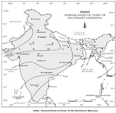
Consider the following statements regarding the Indian monsoon and its onset:

  1. The differential heating of land and sea during summer is responsible for the onset of the Indian monsoon.
  2. The southwest monsoon is a continuation of the southeast trades after crossing the Equator.
  3. The westerly jet stream of Nothern India bring the burst of the monsoon with it.
  4. By mid-July, southwest monsoon spreads to the entire subcontinent.

Which of the statements given above are correct?

Detailed Solution for Practice Test: Geography- 2 - Question 22
  • Statement 1 is correct: The differential heating of land and sea during the summer months is the mechanism which sets the stage for the monsoon winds to drift towards the subcontinent. During April and May when the sun shines vertically over the Tropic of Cancer, the large landmass in the north of Indian ocean gets intensely heated. This causes the formation of an intense low pressure in the northwestern part of the subcontinent.
  • Statement 2 is correct: Since the pressure in the Indian Ocean in the south of the landmass is high as water gets heated slowly, the low pressure cell attracts the southeast trades across the Equator. These conditions help in the northward shift in the position of the ITCZ. The southwest monsoon may thus, be seen as a continuation of the southeast trades deflected towards the Indian subcontinent after crossing the Equator. These winds cross the Equator between 40°E and 60°E longitudes.
  • Statement 3 is incorrect: The shift in the position of the ITCZ is also related to the phenomenon of the withdrawal of the westerly jet stream from its position over the north Indian plain. The easterly jet stream sets in along 15°N latitude only after the western jet stream has withdrawn itself from the region. This easterly jet stream is held responsible for the burst of the monsoon in India.
  • Statement 4 is correct: The southwest monsoon sets in over the Kerala coast by around 1st June and moves swiftly to reach Mumbai and Kolkata between 10th and 13th June. By mid-July, southwest monsoon engulfs the entire subcontinent.

Practice Test: Geography- 2 - Question 23

Consider the following statement with reference to the Universal Postal Union:

  1. It is a specialized agency of United Nation which promotes cooperation between postal sector players.
  2. Only members of United Nations can be the member of the Union.

Which of the statements given above are correct? 

Detailed Solution for Practice Test: Geography- 2 - Question 23
  • Statement 1 is correct: The Universal Postal Union is a United Nations specialized agency and the postal sector's primary forum for international cooperation. It is the second oldest international organization worldwide. The UPU is the primary forum for cooperation between postal sector players. It helps to ensure a truly universal network of up-todate products and services. It sets the rules for international mail exchanges and makes recommendations to stimulate growth in mail, parcel and financial services volumes and improve quality of service for customers.
  • Statement 2 is incorrect: Any member country of the United Nations may become a member of the UPU. Any non-member country of the United Nations may become a UPU member provided that its request is approved by at least twothirds of the member countries of the UPU. The union has currently 192 members.
Practice Test: Geography- 2 - Question 24

Which one of the following is correct with reference to the term ‘Population Momentum’?

Detailed Solution for Practice Test: Geography- 2 - Question 24
  • Population Momentum refers to the tendency for population growth to continue beyond the time that replacement-level fertility has been achieved because of the relatively high concentration of people in the childbearing years. In other words, it refers to a situation, where a large cohort of women of reproductive age will fuel population growth over the next generation, even if each woman has fewer children than previous generations did.
  • Census data from India (i.e., Registrar of India) suggests that population growth is on the decline since 1991. The average number of children a woman expected to give birth to during her life was 3.8 in 1990, and this has fallen to 2.7 children per woman. Even though the fertility and population growth rates are declining, India’s population is projected to increase from 1.2 billion today to an estimated 1.6 billion by 2050 due to population momentum.
Practice Test: Geography- 2 - Question 25

Consider the following statements with reference to the Producer Organisations (PO):

  1. A producer Organisation is formed by farmers only.
  2. It is an organization of the producers, by the producers and for the producers.
  3. The maximum number of members in the organization is restricted to ten members only.

How many of the statements given above are incorrect?

Detailed Solution for Practice Test: Geography- 2 - Question 25
  • Statement 1 is incorrect: The PO is an organization of the primary producers. If the produce in question is a nonfarm item (for example, handloom or handicraft), then the PO will be that of non-farmers.
    The objective of the PO is to ensure better income realization to its members (who are producers) through aggregation and, if feasible, value addition.
  • Statement 2 is correct: The ownership of the PO is with its members. It is an organization of the producers, by the producers and for the producers. One or more institutions and/or individuals may have promoted the PO by way of assisting in mobilization, registration, business planning and operations. However, ownership control is always with members and management is through the representatives of the members.
  • Statement 3 is incorrect: The minimum number of membership depends on the legal form of the Producer Organisation. There is no restriction on the maximum number of membership. Generally, the PO will require certain minimum scale of operation to remain in business. This operation scale/volume is known as breakeven level.
Practice Test: Geography- 2 - Question 26

Consider the following:

  1. Khasi and Jaintia hills
  2. Ladakh
  3. Deccan Plateau
  4. Northern plains

Which of the following is the correct order of decreasing rainfall for the above regions?

Detailed Solution for Practice Test: Geography- 2 - Question 26
  • The average annual rainfall in India is about 125 cm, but it has great spatial variations.
  • Areas of High Rainfall: The highest rainfall occurs along the west coast, on the Western Ghats, as well as in the subHimalayan areas is the northeast and the hills of Meghalaya. Here the rainfall exceeds 200 cm. In some parts of Khasi and Jaintia hills, the rainfall exceeds 1,000 cm. In the Brahmaputra valley and the adjoining hills, the rainfall is less than 200 cm.
  • Areas of Medium Rainfall: Rainfall between 100-200 cm is received in the southern parts of Gujarat, east Tamil Nadu, northeastern Peninsula covering Odisha, Jharkhand, Bihar, eastern Madhya Pradesh, northern Ganga plain along the subHimalayas and the Cachar Valley and Manipur.
  • Areas of Low Rainfall : Western Uttar Pradesh, Delhi, Haryana, Punjab, Jammu and Kashmir, eastern Rajasthan, Gujarat and Deccan Plateau receive rainfall between 50-100 cm.
  • Areas of Inadequate Rainfall: Parts of the Peninsula, especially in Andhra Pradesh, Karnataka and Maharashtra, Ladakh and most of western Rajasthan receive rainfall below 50 cm.
Practice Test: Geography- 2 - Question 27

With reference to Carbon Capture and Storage technology, which of the following statements is correct?

  1. The Possible storage sites for carbon emissions include saline aquifers or depleted oil and gas reservoirs.
  2. United States was the first country to utilize this technology.

Select the correct answer using the code given below:

Detailed Solution for Practice Test: Geography- 2 - Question 27
  • Statement 1 is correct: Carbon capture and storage (CCS) is a way of reducing carbon emissions, which could be key to helping to tackle global warming. It’s a three-step process, involving: capturing the carbon dioxide produced by power generation or industrial activity, such as steel or cement making; transporting it; and then storing it deep underground. Possible storage sites for carbon emissions include saline aquifers or depleted oil and gas reservoirs, which typically need to be 0.62 miles (1km) or more under the ground.
  • Statement 2 is correct: CCS has been in operation since 1972 in the US, where several natural gas plants in Texas have captured and stored more than 200 million tons of CO2 underground. According to the Global CCS Institute’s 2022 report, there were 194 large-scale CCS facilities globally at the end of the year – compared to 51 in 2019 – 61 of which were new CCS facilities added to the project pipeline in 2022. 30 of these projects are in operation, 11 under construction and the remainder in various stages of development.
Practice Test: Geography- 2 - Question 28

Consider the following statements:

  1. Replacement level is the rate of growth required for new generations to replace the older ones that are dying out.
  2. Total Fertility Rate (TFR) of 2 is known as the replacement rate.
  3. India’s TFR is more than the Replacement level fertility rate.

How many of the above statements are correct?

Detailed Solution for Practice Test: Geography- 2 - Question 28
  • Statement 1 is correct: The rate of natural increase or the growth rate of population refers to the difference between the birth rate and the death rate. When this difference is zero (or, in practice, very small) then it is said that the population has ‘stabilised’, or has reached the „replacement level’, which is the rate of growth required for new generations to replace the older ones that are dying out.
  • Sometimes, societies can experience a negative growth rate, that is, their fertility levels are below the replacement rate.
  • Statement 2 is incorrect: Total Fertility Rate (TFR) represents the number of children that would be born to a woman if she were to live to the end of her childbearing years and bear children in accordance with age-specific fertility rates of the specified year. A TFR of 2.1 is known as the replacement rate.
  • Statement 3 is incorrect: The TFR of India is 2.0 which is less than the replacement level fertility rate.
Practice Test: Geography- 2 - Question 29

Consider the following statements with reference to the Farmers Distress Index:

  1. It is published by Central Island Agricultural Research Institute.
  2. Its main goal is to minimise the agrarian distress in the form of crop loss and income shock.
  3. The degree of distress will be identified on the basis of twenty one questions.

Which of the statements given above are correct? 

Detailed Solution for Practice Test: Geography- 2 - Question 29
  • Statement 1 is incorrect: The Central Research Institute for Dryland Agriculture (CRIDA), an institution under the Indian Council of Agricultural Research (ICAR) started working on a kind of an early warning system called ‘farmers distress index’, a first of its kind for India. The work is in the final stages and the index will be handed over to the central government in the next two-three months.
  • Statement 2 is correct: The main aim behind creating such an index is to minimise the agrarian distress in the form of crop loss / failure and income shock.
    Farmers’ exposure to shocks have increased in the recent years, with an increase in extreme climate events as well as market and price fluctuations, many times driving them to death by suicides.
  • Statement 3 is correct: Based on these 21 questions, the degree of distress will be identified. The index will have values from 0-1. A value between 0-0.5 will indicate ‘low distress’, 0.5-0.7 will indicate ‘moderate’ distress and above 0.7 will indicate ‘severe’ distress. If the index is severe, it will identify which component, among the seven, is more severe and contributes maximum to farmers’ distress. The index is currently being worked out in the form of a mobile or desktop application.
Practice Test: Geography- 2 - Question 30

Consider the following statements:

  1. The natural growth of the population is assessed through crude birth and death rates.
  2. The induced growth of the population is explained by migration patterns of the population.

Which of the statements given above are correct? 

Detailed Solution for Practice Test: Geography- 2 - Question 30

Growth of population is the change in the number of people living in a particular area between two points in time. Its rate is expressed in percentage.
Statement 1 is correct: Population growth has two components namely; natural and induced. The natural growth is analysed by assessing the crude birth and death rates. Crude birth rate indicates the number of live births occurring during the year, per 1,000 population estimated at midyear.
Statement 2 is correct: The induced components are explained by the volume of inward and outward movement of people in any given area.

View more questions
Information about Practice Test: Geography- 2 Page
In this test you can find the Exam questions for Practice Test: Geography- 2 solved & explained in the simplest way possible. Besides giving Questions and answers for Practice Test: Geography- 2, EduRev gives you an ample number of Online tests for practice

Top Courses for UPSC

Download as PDF

Top Courses for UPSC