Civil Engineering (CE) Exam  >  Civil Engineering (CE) Tests  >  Test: Highway Transportation- 1 - Civil Engineering (CE) MCQ

Test: Highway Transportation- 1 - Civil Engineering (CE) MCQ


Test Description

25 Questions MCQ Test - Test: Highway Transportation- 1

Test: Highway Transportation- 1 for Civil Engineering (CE) 2025 is part of Civil Engineering (CE) preparation. The Test: Highway Transportation- 1 questions and answers have been prepared according to the Civil Engineering (CE) exam syllabus.The Test: Highway Transportation- 1 MCQs are made for Civil Engineering (CE) 2025 Exam. Find important definitions, questions, notes, meanings, examples, exercises, MCQs and online tests for Test: Highway Transportation- 1 below.
Solutions of Test: Highway Transportation- 1 questions in English are available as part of our course for Civil Engineering (CE) & Test: Highway Transportation- 1 solutions in Hindi for Civil Engineering (CE) course. Download more important topics, notes, lectures and mock test series for Civil Engineering (CE) Exam by signing up for free. Attempt Test: Highway Transportation- 1 | 25 questions in 50 minutes | Mock test for Civil Engineering (CE) preparation | Free important questions MCQ to study for Civil Engineering (CE) Exam | Download free PDF with solutions
Test: Highway Transportation- 1 - Question 1

In 1927, Jayakar committee was set up to examine and report on road development in India,abased on which certain institutions were subsequently set certain institutions were subsequently set up. Which of the following were the direct out come of Jayakar committee recommendations.

1. Indian Road Congress

2. Central Road fund

3. CRRI

4. National Highway Act

Detailed Solution for Test: Highway Transportation- 1 - Question 1

Correct Answer :- a

Explanation : In 1927 Jayakar committee for Indian road development was appointed. The major recommendations and the resulting implementations were :

 This paved the way for the establishment of a semi-official technical body called Indian Road Congress (IRC) in 1934.

Test: Highway Transportation- 1 - Question 2

The semiofficial body set up for controlling and standardization of roads and bridges in India is

Detailed Solution for Test: Highway Transportation- 1 - Question 2

The Indian Roads Congress (IRC) is the Apex Body of Highway Engineers in the country. The IRC was set up in December, 1934 on the recommendations of the Indian Road Development Committee best known as Jayakar Committee set up by the Govt. of India with the objective of Road Development in India. 

Test: Highway Transportation- 1 - Question 3

Select the correct statement.

Detailed Solution for Test: Highway Transportation- 1 - Question 3

Second 20 Year Plan focused on developing highway infrastructure in India.

  • The plan aimed to provide 1600 km of expressways as part of the proposed national highway system.
  • This initiative was designed to enhance connectivity and support economic growth.
  • It included strategies for the efficient use of existing transport networks.
  • Significantly, the plan allowed for the detection of railway track lengths when calculating road lengths.

This comprehensive approach aimed to ensure that road development met the needs of urban and rural areas alike.

Test: Highway Transportation- 1 - Question 4

Which of the following roads are congested during peak hours?

Detailed Solution for Test: Highway Transportation- 1 - Question 4

The urban roads mostly in cities and towns are congested during morning and evening times due to the school, college and office timings.

Test: Highway Transportation- 1 - Question 5

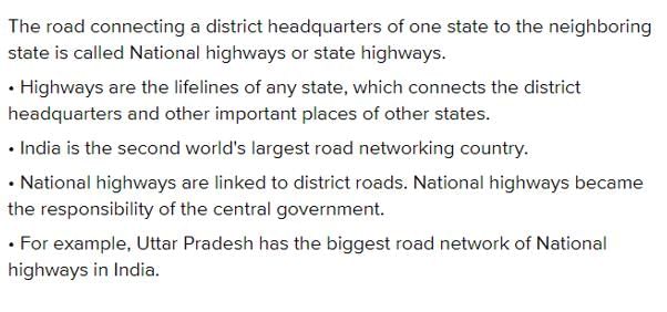
The road connecting a district headquarters of one state to the district headquarters of neighbouring state is called

Detailed Solution for Test: Highway Transportation- 1 - Question 5

Test: Highway Transportation- 1 - Question 6

Major district roads connect market and production areas within a district to

Detailed Solution for Test: Highway Transportation- 1 - Question 6

The Nagpur Plan divided the District Roads into two classes and the District Roads were defined as roads traversing each district, serving areas of production and markets and connecting these with each other or with highways and railways.

The state highways are usually roads that link important cities, towns, district headquarters, tourist centres and minor ports within the state, and connect them with National Highways or highways of neighboring states. These highways provide connections to industries or places from key areas in the state, making them more accessible.

Test: Highway Transportation- 1 - Question 7

The city roads providing an access to residence, business and other buildings are called

Detailed Solution for Test: Highway Transportation- 1 - Question 7

City roads that provide access to residences, businesses, and other buildings are categorised into different types based on their function.

  • Arterial streets: Major routes designed for high traffic volumes and long-distance travel.
  • Sub-arterial streets: Secondary routes that connect arterial streets, accommodating moderate traffic.
  • Collector streets: Streets that gather traffic from local streets and direct it to arterial roads.
  • Local streets: Roads primarily serving residential areas, designed for lower traffic volumes.

Among these, the sub-arterial street plays a critical role in connecting neighbourhoods and facilitating access to various local amenities.

Test: Highway Transportation- 1 - Question 8

The branch of engineering that deals with improvement of traffic performance, traffic studies and traffic network is called

Detailed Solution for Test: Highway Transportation- 1 - Question 8

The branch of engineering that deals with improvement of traffic performance, traffic studies and traffic network is called as traffic engineering, it also includes geometric design and other specifications.

Test: Highway Transportation- 1 - Question 9

Which of the following statement is correct? According to the principle of road alignment

Detailed Solution for Test: Highway Transportation- 1 - Question 9

The principle of road alignment considers several factors to ensure that the road is efficient, safe, and economically viable.
Here's why each statement is correct:

  • B: Its gradient should be easy: The gradient of the road should not be too steep to ensure safe driving conditions and to reduce wear and tear on vehicles. It should be smooth and manageable.

  • C: It should aim at avoiding deep cuttings and fillings: Deep cuttings (digging into the earth) and fillings (piling earth) can be expensive and environmentally disruptive. Road alignment aims to minimize these, as they add to the cost and environmental impact of the project.

  • D: It should be straight: While roads do not need to be entirely straight, the principle of alignment aims to keep the road as straight as possible within the constraints of the terrain to minimize travel distance and ensure smoother driving conditions.

Thus, A: all the below is the correct choice, as it encompasses all the principles of good road alignment.

Test: Highway Transportation- 1 - Question 10

The sequence of survey in a road project is

Detailed Solution for Test: Highway Transportation- 1 - Question 10

The sequence of surveys in a road project is as follows:

  • Topographic survey: This involves mapping the physical features of the land, including elevations, contours, and existing structures. It provides essential data for design.

  • Reconnaissance survey: A preliminary assessment of the area. It helps identify the best routes and any potential challenges or obstacles.

  • Preliminary survey: A more detailed examination of the chosen route. This includes gathering data on soil conditions, hydrology, and environmental impacts.

  • Detailed survey: The final and most precise survey. It focuses on specific design requirements and incorporates all relevant data for construction plans.

Test: Highway Transportation- 1 - Question 11

The main object of a preliminary survey

Detailed Solution for Test: Highway Transportation- 1 - Question 11

Correct Answer :- a

Explanation : The main objectives of the preliminary surveys are:

 To survey the various alternate alignments proposed after the reconnaissance and to collect all the necessary physical information and details of topography, drainage and soil.

All geographical and other man made features along the traverse and for a certain width on either side surveyed and plotted.

Test: Highway Transportation- 1 - Question 12

In the final survey the centre line stakes are driven at interval in plain terrain.

Detailed Solution for Test: Highway Transportation- 1 - Question 12

In the final survey, the center line stakes are typically driven at an interval of 50 meters in plain terrain for detailed and accurate surveying. This interval helps in providing sufficient control points for measurements and ensuring the alignment of the project.

While other distances like 100m or more may be used in specific situations, 50 meters is the standard interval for staking in plain terrain.

Test: Highway Transportation- 1 - Question 13

In the final survey the centre line stakes are driven at interval in hilly terrain.

Detailed Solution for Test: Highway Transportation- 1 - Question 13

In hilly terrain, the distance between centre line stakes is crucial for accurate surveying. The recommended intervals for driving these stakes are as follows:

  • 10 m - Suitable for very detailed work in steep areas.
  • 20 m - A good balance for moderate detail and accuracy.
  • 30 m - Useful for less complex terrains.
  • 50 m - Ideal for flatter, less detailed surveys.

Choosing the right interval depends on the specific requirements of the survey and the terrain features.

Test: Highway Transportation- 1 - Question 14

In preliminary survey of a road project, in hilly region cross sections are taken generally at.

Detailed Solution for Test: Highway Transportation- 1 - Question 14

Longitudinal & Cross-sectional Profile→

Plain Terrain:100-200m

Rolling Terrain:50m

Hilly Terrain:30m

Test: Highway Transportation- 1 - Question 15

The final report on road project should include

Detailed Solution for Test: Highway Transportation- 1 - Question 15

The final report on a road project should include the following key components:

  • Land acquiescence plan: This outlines the agreements and permissions regarding land use.

  • Cross-drainage details: Essential for managing water flow and preventing flooding on the road.

  • Plans of quarries: Information about the sources of materials for the project, including location and capacity.

Each of these elements is crucial for ensuring the project is viable and sustainable.

Test: Highway Transportation- 1 - Question 16

Ascending order according to width is

Detailed Solution for Test: Highway Transportation- 1 - Question 16

Ascending order according to width:

  • Carriageway - This is the main part of the road where vehicles travel.
  • Formation width - This refers to the total width of the road structure, including the carriageway and shoulders.
  • Right of way - This is the legal right to pass through or over a property or area, typically wider than the carriageway.

The correct order, from the narrowest to the widest, is:

  • Carriageway
  • Formation width
  • Right of way
Test: Highway Transportation- 1 - Question 17

Consider the following statements in the context of the geometric design of roads

I: A simple parabolic curve is an acceptable shape of summit curves

II: Comfort to passengers is an important consideration in the design of summit curves.

The correct option evaluating the above statements and their relationship is

Detailed Solution for Test: Highway Transportation- 1 - Question 17

Vertical curve:

Vertical alignment is the elevation of the centerline of the road. It may be in the form of a circular arc or a parabola

The common practice has been to use parabolic curves in summit curves. Parabolic curves with it can be laid out with ease as well as allowing a comfortable transition from one gradient to another. Hence statement I is true.

Although a circular curve offers equal sight distance at every point on the curve, for very small deviation angles a circular curve. and parabolic curves are almost congruent.

In valley curves the centrifugal force will be acting downwards along with the weight of the vehicle and hence impact to the vehicle will be more. It will result in jerking and cause discomfort to passengers. Hence comfort to passengers has to be considered in valley curves. Hence statement II is false.

Test: Highway Transportation- 1 - Question 18

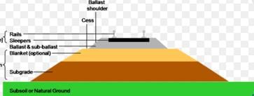
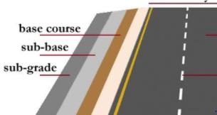
The portion of the roadway between outer edges of carriageway and drains in case of cuttings is known as

Detailed Solution for Test: Highway Transportation- 1 - Question 18

The portion of the roadway between the outer edges of the carriageway and the drains in case of cuttings is known as:

  • The shoulder is the area adjacent to the roadway.
  • It provides space for vehicles to pull over safely.
  • The shoulder enhances safety by accommodating breakdowns.
  • It also assists in drainage by directing water away from the road.

Understanding the role of the shoulder is essential for road design and maintenance.

Test: Highway Transportation- 1 - Question 19

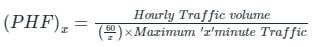
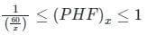
The minimum value of 15 minute peak hour factor on a section of a road is

Detailed Solution for Test: Highway Transportation- 1 - Question 19

The peak hour factor (PHF) is defined as.

Less PHF means that more congestion.

The minimum value of PHF is  and Maximum value is 1.

Given:

x = 15 minute.

Test: Highway Transportation- 1 - Question 20

The order in which a road is built is

Detailed Solution for Test: Highway Transportation- 1 - Question 20

Test: Highway Transportation- 1 - Question 21

The traffic starts discharging from an approach an intersection with the signal turning green. The constant headway considered from the fourth or fifth headway position is referred as

Detailed Solution for Test: Highway Transportation- 1 - Question 21

Time Headway:- It is the time interval between the passes of the rear bumper of successive vehicles at a point.

  • When the signal at an intersection turns green, the vehicles in the queue will start crossing the intersection. The first driver in the queue needs to observe and react to the signal change at the start of green time and the second driver does the same but only when he see the first vehicle moving.
  • This results in a shorter headway than the first because the driver had an extra vehicle length to accelerate. This process carries through with all following vehicles where each vehicle’s headway will be slightly shorter than the preceding vehicle.
  • This continues until a certain number of vehicles have crossed the intersection and start-up reaction and acceleration no longer affect the headways.
  • The headway will remain constant beyond this point and this constant headway is known as the saturation headway. It generally occurs after the fourth or fifth vehicle passes the intersection.
Test: Highway Transportation- 1 - Question 22

Base course of a road is built with

Detailed Solution for Test: Highway Transportation- 1 - Question 22

The base course of a road is crucial for ensuring stability and durability. It typically consists of:

  • Gravel: A mixture of rock fragments that provides drainage.
  • Sand: Helps with compaction and stability.
  • Silt: Fills voids between larger particles, enhancing the mix.
  • Stabilised soil: Soil treated to improve its strength and durability.
  • Selected granular soil: Carefully chosen soil types that meet specific engineering requirements.
  • Broken stone aggregates: Crushed stone that offers resistance to deformation.

These materials are often combined to create a strong and stable base layer, which is essential for supporting the overlying layers of the road. The choice of materials depends on factors such as local availability, cost, and the expected load on the road.

Test: Highway Transportation- 1 - Question 23

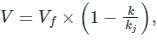
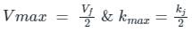
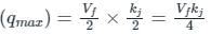
The speed-density relationship in a mid-block section of a highway follows the Greenshields’s model. If the free flow speed is vf and the jam density is kj , the maximum flow observed on this section is

Detailed Solution for Test: Highway Transportation- 1 - Question 23

Flow (q) = Density (k) × Velocity (V)

For Greenshields’s Model

Where,

V = Velocity at any instant

Vf = Free mean velocity

k = Density of the flow

kj = Jam density of the flow

Maximum capacity (qmax) = Vmax × Kmax

As per Greenshields’s model

Maximum capacity ⇒ 

Test: Highway Transportation- 1 - Question 24

The factor influencing camber is

Detailed Solution for Test: Highway Transportation- 1 - Question 24

Road Camber height depends upon

  1. Rainfall intensity in the area.
  2. Type of the road surface whether it is flexible or rigid.
  3. In case of flexible pavement, the recommended height of camber is 2 %. of the total width of the pavement.
  4. For rigid pavement, the maximum recommended width is 1:72 .
Test: Highway Transportation- 1 - Question 25

Two cars P and Q are moving in a racing track continuously for two hours. Assume that no other vehicles are using the track during this time. The expressions relating the distance travelled d (in km) and time t (in hour) for both the vehicles are given as

P (d) = 60t

Q (d) = 60t2

Within the first one hour, the maximum space headway would be

Detailed Solution for Test: Highway Transportation- 1 - Question 25

P: d = 60t

Q: d = 60t2

Space Headway (S) = 60t2 – 60t

For space headway to be max,

dsdt=0

120t – 60 = 0

⇒ 60(2t – 1) = 0

⇒ t = ½ hr

Maximum space Headway

= 60 × ½ - 60 × (½)2

= 60 × ½ - 60 × ¼

= 30 – 15 = 15 km

Information about Test: Highway Transportation- 1 Page
In this test you can find the Exam questions for Test: Highway Transportation- 1 solved & explained in the simplest way possible. Besides giving Questions and answers for Test: Highway Transportation- 1, EduRev gives you an ample number of Online tests for practice
Download as PDF