Software Development Exam  >  Software Development Tests  >  Test: Geography - I - Software Development MCQ

Test: Geography - I - Software Development MCQ


Test Description

20 Questions MCQ Test - Test: Geography - I

Test: Geography - I for Software Development 2025 is part of Software Development preparation. The Test: Geography - I questions and answers have been prepared according to the Software Development exam syllabus.The Test: Geography - I MCQs are made for Software Development 2025 Exam. Find important definitions, questions, notes, meanings, examples, exercises, MCQs and online tests for Test: Geography - I below.
Solutions of Test: Geography - I questions in English are available as part of our course for Software Development & Test: Geography - I solutions in Hindi for Software Development course. Download more important topics, notes, lectures and mock test series for Software Development Exam by signing up for free. Attempt Test: Geography - I | 20 questions in 20 minutes | Mock test for Software Development preparation | Free important questions MCQ to study for Software Development Exam | Download free PDF with solutions
Test: Geography - I - Question 1

Which type of soil is mostly found in Haryana state?

Detailed Solution for Test: Geography - I - Question 1

The correct answer is Alluvial soil.

Key Points

  • In Haryana state, alluvial type of soil is mostly found.
  • Alluvial soil is having silt, sand, clay, and gravel as well as much organic matter.
  • It is porous as well as light, so it is easily tillable.
  • On the basis of its ages alluvial soil is divided into Bhangar (Old alluvium) and Khadar (New alluvium).
  • It is among the most fertile soils of India.
  • Major crops grown on this soil are rice, wheat, sugarcane, cotton, jute, potato, and vegetables.

Additional Information

  • Laterite soil:
    • Laterite Soil is poor in lime, phosphorous, calcium, and nitrogen.
    • Bricks are made for house construction by laterite soil.
    • Laterite Soil is peculiar to India- Andhra Pradesh, Tamil Nadu, West Bengal, and Odisha.
    • Cashew, Tapioca, Coffee, and Rubber are the important crops of laterite soil.
  • Black soil:
    • Black soil is also known as regur soil.
    • Black soil has a high water-retaining capacity.
    • Black soil has poor nitrogen content.
  • Red and yellow soil:
    • It is found in the eastern part of the peninsular region covering Chotanagpur Plateau, Odisha, eastern Chhattisgarh, etc.
    • It is suitable for the production of crops such as wheat, rice, millets, pulses, etc.
    • Red colour due to wide diffusion of iron in crystalline and metamorphic rocks.
    • Yellow colour when it is in hydrated form. These soils are fine-grained and fertile.
    • It is poor in nitrogen, phosphorus and humus.
Test: Geography - I - Question 2

With reference to India, Reh, Kallar, Chopan and Rakar are the names of

Detailed Solution for Test: Geography - I - Question 2

The correct answer is Saline and Alkaline Soils.

Key Points

Saline and Alkaline Soils

  • They are also known as Usara soils.
  • Various local names for saline soils are Reh, Kallar, Chopan, Rakar, Thur, Karl, etc. Hence, Option 3 is correct.
  • These soils have developed in areas with dry climatic conditions accompanied by a lack of proper drainage.
  • In this situation, salts of sodium, calcium, and magnesium are deposited on the upper layer of the soil by capillary action.
  • Some of the salts are transported in solution by the rivers.
  • These soils are also formed when saline water spreads on the land at the time of high tide in coastal areas.
  • Their texture ranges from sandy to loamy.
  • Saline and Alkaline Soils occupy 68,000 sq km of area.
  • Parts of Andhra Pradesh, Telangana, Karnataka, Bihar, Uttar Pradesh, Haryana, Punjab (side effects of improper or excess irrigation), Rajasthan and Maharashtra have this kind of soil.
  • The accumulation of these salts makes the soil infertile and renders it unfit for agriculture.
Test: Geography - I - Question 3

What type of soil is found on the hills of Morni in the state?

Detailed Solution for Test: Geography - I - Question 3

The correct answer is Rocky soil.

Key Points

  • The land of Haryana can be divided into the following three parts:
    • Hill:
      • The soil of this region is rocky and this type of soil can be seen on the hills of Morni.
      • In the southern part of the state, due to the presence of hills of the Aravalli Mountains, rocky and sandy soils are found here.
      • The soil in the hilly region of the state is thin and hard.
    • Plains:
      • The soil of the plains of the state is fertile.
      • It is brownish-yellow in color.
      • This soil has come with the flow of rivers like Yamuna, Saraswati etc.
      • Many crops are grown in this region and the most fertile region is also considered to be the plains of Haryana.
    • Sandy:
      • Sandy soil is found in the southwestern part of Haryana.
      • The color of this soil is light brown.
      • This soil comes with the winds blowing from the neighboring state of Rajasthan.
Test: Geography - I - Question 4
When was Jhajjar seperated from Rohtak district of Haryana?
Detailed Solution for Test: Geography - I - Question 4

The correct answer is 15th July, 1997.

Key Points

  • Jhajjar was separated from Rohtak district on 15th July 1997 (officially).
  • Jhajjar district was created out of Rohtak district by carving out Jhajjar and Bahadurgarh tahsils on 25th June 1997. 
  • During the period of 1991-2001, the following jurisdictional changes were observed.:
    • Bahadurgarh tahsil contained 62 villages and Bahadurgarh Town.
    • Jhajjar tahsil contained 199 villages and two towns, namely, Jhajjar and Beri, and these were part of Rohtak district.
    • Beri tahsil was newly created on 27th July 1995 by transferring 39 villages and Beri Town from Jhajjar tahsil.
    • Bahadurgarh tahsil gained 9 villages from Jhajjar tahsil and lost 2 villages to Rohtak tahsil (Rohtak district).


Test: Geography - I - Question 5

Khadar and Bhangar are which type of soil?

Detailed Solution for Test: Geography - I - Question 5
  • Soils are complex mixtures of minerals, water, air, organic matter, and countless organisms that are the decaying remains of once-living things.
  • Soils are formed as a result of weathering of rocks.
  • India has varied relief features, landforms, climatic realms and vegetation types.
  • These have contributed to the development of various types of soils in India.
  • Each soil has unique properties and characteristics.

Key-Points
Riverine soil:

  • Khadar and Bhangar are types of riverine i.e. alluvial soil.
  • Alluvial soil is also known as riverine soil because it is found in river basins and is formed when the velocity of streams and rivers slows.
  • Alluvial soil is formed by the deposition of sediments carried by rivers starting from the mountains (its origin).
  • When the river overflows, this soil is deposited on the riverbanks.

​​Important Points
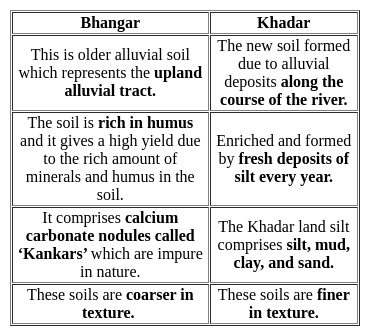
Some important points that distinguish between Khadar and Bhangar are:

Thus, Khadar and Bhangar are types of riverine i.e. alluvial soil.

Additional Infromation

Makherla soil: It is another name for laterite soil.
Regur soil: It is another name for black soil.
Urvara soil: It is the name for soils that are fertile in nature.

Test: Geography - I - Question 6

Which river originates from Sewar hills?

Detailed Solution for Test: Geography - I - Question 6

The correct answer is Sahibi.

Key Points

  • River Sahibi originates from Sewar hills.

Additional Information

  • Sota-Sabi or Sahibi River
    • There are two branches, the Sahibi branch rises from Sewar hills and the Sota branch rises from the hills of Bairath.
    • The two branches meet at Jalalpur.
    • The river flows in the northern direction through Kotputli tehsil, Bansur, Behror Kishangarh, Mundawar (Rajasthan) Rewari (Haryana) and empties into Najafgarh drain.
    • Sabi basin is bounded in the northwest by Shekhawati River Basin and Ruparail and Banganga
    • River basins in the southeast. The northern boundary is shared administratively with Haryana State.
    • The Basin extends over parts of the Alwar, Jaipur and Sikar districts.
    • The total catchment area of the Sahibi basin is 4607.9 km2.
    • It flows in Rajasthan for a distance of about 157 km before entering Haryana State
Test: Geography - I - Question 7

Which of the following National Parks is situated in Gurgaon District?

Detailed Solution for Test: Geography - I - Question 7

The correct answer is Sultanpur National Park.

About Sultanpur National park:

  • It is located at Sultanpur village on Gurgaon - Jhajjar highway, 15 km from the Gurgaon district in Haryana, and 50 km from New Delhi.
  • Sultanpur National park covers approximately 142.52 Hectares of area. This National Park was formerly a Bird sanctuary.
  • In this National park, many of the Birds varieties are there like Paddy field Pipit, Eurasian Knick knee, Gray Francolin, Black Francolin, Indian Roller, Purple Sunbird, Little Cormorant, Pigeons, etc.
  • It is named after Chauhan Rajput Raja Sultan Singh Chauhan, a great-grandson of 'Harsh Dev Singh Chauhan (descendent of Great Prithvi Raj Chauhan).
  • The Sultanpur National Park officially became a National park on 13 July 1989 and has an area of 1.43 km(Under that Chief Minister of Haryana Bansi Lal).

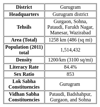
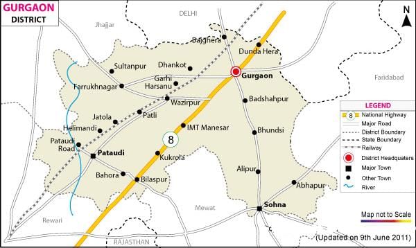
About Gurgaon (Gurugram District):

Map view of Gururam district (Haryana state):

Notes:

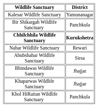
  • Some of the Haryana state wildlife sanctuaries are (Nahar wildlife sanctuary, Chhilchhila wildlife sanctuary), Natural parks are (Sultanpur National Park, and Kalesar National Park)
  • The largest Bird Sanctuary of India is Nal Sarovar Bird Sanctuary located in Gujarat.
  • The smallest Bird Sanctuary of India is the Vedanthangal Bird Sanctuary located in the Kancheepuram district of Tamil Nadu.
Test: Geography - I - Question 8
Chautang river originates from ____________.
Detailed Solution for Test: Geography - I - Question 8
  • Chautang river originates from the foothills of Shivalik in Himachal Pradesh.
  • It serves as the seasonal river in Haryana.
  • According to vedic age it was termed as Drishadvati river where Indus-Sarasvati civilization grew.
Test: Geography - I - Question 9
In which of the following districts Chhilchhila Wildlife Sanctuary  is situated?
Detailed Solution for Test: Geography - I - Question 9

The correct answer is Kurukshetra.

Test: Geography - I - Question 10
Haryana became the 17th state of India in 1966 on the recommendation of which of the following committee?
Detailed Solution for Test: Geography - I - Question 10

The correct answer is the Sardar Hukum Singh committee.

  • Haryana became the 17th state of India in 1966 on the recommendation of the Sardar Hukum Singh committee.

Key Points

  • After the independence of India in 1947, Haryana remained part of Punjab.
  • But Hindus and Sikhs both demanded separate states.
  • This movement gained momentum after 1955 and had its full intensity in 1960.
  • Haryana was separated from Punjab in 1966 with the passage of the Punjab reorganization act and on the recommendation of the Sardar Hukum Singh parliamentary committee.
  • This committee was formed in 1965.
Test: Geography - I - Question 11
As per the state of forest report 2021, the tree cover in the state of Haryana is
Detailed Solution for Test: Geography - I - Question 11

The correct answer is 1603 sq km.

Key Points

  • As per the state of forest report 2021, the tree cover in the state of Haryana is 1603 square km
    • The survey was conducted between October 2019 and February 2020 for the assessment year 2021.
    • The forest cover in the state is 1,603.48 km, which is 3.63% of the state's geographical area. The forest area of the state was recorded at 1,602.44 in 2019, 1,588 sq km in 2017 and 1,580 sq km in the 2015 report.
Test: Geography - I - Question 12
Which of the following is the tributary of river Tangri ?
Detailed Solution for Test: Geography - I - Question 12
  • Tangri river is also known as Dangri river has two tributaries namely Balaiali river and Amri river which originates from the foothills of Shivalik mountains near Haryana and Himachal Pradesh border.
  • Tangri river has an entire length of about 70 km after which it discharges into Ghaggar river. 
Test: Geography - I - Question 13
The Markanda river does not flow in which of the following district?
Detailed Solution for Test: Geography - I - Question 13

Sonipat is NOT correct.

  • The Markanda river flows in Sirmaur district, Ambala district, and Markanda town in Kurukshetra district.
  • The river flows through Haryana and Himachal Pradesh.

Key Points

  • The ancient name of the Markanda river is Aruna river.
  • The Markanda river originates from the Shivalik hills and flows along the Haryana-Punjab border.
  • The Begna river is the main tributary of the Markanda river.
  • The total length of the river is 120 km out of which 90 km is in Haryana.
  • A barrage at Jalbehra in Kurukshetra district has been built on the river. 

Additional Information

  • The Ghaggar river is an intermittent river that flows during the monsoon season only. 
    • It originates in Shivalik hills in Himachal Pradesh.
    • It flows through the states of Himachal Pradesh, Haryana, Punjab, and Rajasthan.
    • Main tributaries of Ghaggar river are Markanda, Kaushalya, Sursuti, Tangri, and Chautang.
    • The total length of the river is 489 km, out of which 250 km lies in Haryana.
Test: Geography - I - Question 14
Which river is believed to have originated from the Har-ki-Dun glacier in West Garhwal of Haryana ?
Detailed Solution for Test: Geography - I - Question 14

Solution-

  • Haryana does not have any perennial river of its own. The important rivers flowing through the state are the Yamuna, Saraswati, and Ghaggar. These rivers are one of the sources of irrigation in Haryana. Following are the major rivers of Haryana state-
    • Yamuna River
    • Ghaggar River
    • Saraswati River
    • Dohan River
    • Tangri River
    • Krishnavati River
    • Sahibi River
    • Markanda River
    • Chetang River
    • Rakshi River
    • Indori River

Saraswati River:

  • Origin - Har-ki-Doon Glacier from Garhwal (Uttaranchal) (approximate).
  • Admission in Haryana- Ambala.
  • Passes through districts- Ambala, Kurukshetra.
  • Tributaries- Tangri, Markanda, Chutang.
  • Merger or Termination- Joins the Ghaggar river in Sangrur (Punjab).

Additional InformationDohan River:

  • Origin - It originates from Mandholi village near Neem Ka Thana in the Sikar district of Rajasthan.
  • Entry in Haryana- Rewari.
  • It passes through the districts- of Rewari and Mahendragarh.
  • Merging or ending - merges into the Yamuna at Mahendragarh.
  • Dohan River is a rainy river that originates in Mandoli village near Neem Ka Thana in the Sikar district of Rajasthan. It is a tributary of the Sahibi River, which later joins the Yamuna.

Ghaggar River:

  • Origin: It originates from a place called Dagshai (Shimla) in the Shivalik hills of Himachal Pradesh.
  • Entry in Haryana- Pinjore (Panchkula).
  • It passes through the districts- of Panchkula, Ambala, Kaithal, Fatehabad, and Sirsa.
  • Tributaries- Kaushalya River, Markanda, Saraswati, Tangri and Chautang.
  • Merger or Termination- After Sirsa, it enters Rajasthan and becomes extinct.
  • Dam and Kund- Kaushalya Dam (Panchkula), Chamala Dam, Dangarna Dam
Test: Geography - I - Question 15
‘Ghagghar Ka Maidan’ is situated at
Detailed Solution for Test: Geography - I - Question 15

The correct answer is In the districts of Ganganagar & Hanumangarh.

Key Points

  • 'Ghagghar ka Maidan' is situated in the districts of Ganganagar and Hanumangarh.
  • The Ghaggar-Hakra River is an intermittent river in India and Pakistan that flows only during the monsoon season.
    • The river is known as Ghaggar in India, before the Ottu barrage, and as the Hakra in Pakistan, downstream of the barrage, ending in the Thar desert.
  • In pre-Harappan times the Hakra was a tributary of the Sutlej.
    • It is still connected to this paleochannel of the Sutlej, and possibly the Yamuna, which ended in the Nara River, presently a delta channel of the Indus River joining the sea via Sir Creek.

Additional Information

  • The Ghaggar is an intermittent river in India, flowing during the monsoon rains.
    • It originates in the village of Dagshai in the Shivalik Hills of Himachal Pradesh at an elevation of 1,927 meters (6,322 ft) above mean sea level and flows through Punjab and Haryana states into Rajasthan just southwest of Sirsa, Haryana, and by the side of Talwara Lake in Rajasthan.
    • Dammed at Ottu barrage near Sirsa, Ghaggar feeds two irrigation canals that extend into Rajasthan.
  • The main tributaries of the Ghaggar are the Kaushalya river, Markanda, Sarsuti, Tangri and Chautang.
  • The Kaushalya river is a tributary of Ghaggar river on the left side of Ghaggar-Hakra,
  • It flows in the Panchkula district of Haryana state of India and confluences with Ghaggar river near Pinjore just downstream of Kaushalya Dam.
Test: Geography - I - Question 16
Which one of the following rivers in Haryana is now become extinct?
Detailed Solution for Test: Geography - I - Question 16

The correct answer is Saraswati.

  • Saraswati river has been linked closely to Vedic civilization.
  • It is now extinct and known as the ‘disappeared’ river.
  • The government of Haryana is planning to revive lost Saraswati by pumping groundwater and borrowing water from the Yamuna river.
  • Chautang, Drishtawati, Dohan and Krishnawati are facing near extinction like Saraswati.

  • The first figure shows the early Vedic course of the river while the second figure shows the current situation.
Test: Geography - I - Question 17
Which of the given rivers is a tributary of the Ghaggar River?
Detailed Solution for Test: Geography - I - Question 17

The correct answer is option 2 i.e Kaushalya.

  • The Ghaggar-Hakra River flows through India and Pakistan only during the monsoon season.
    • Originated from Shivalik Hills, Himachal Pradesh.
    • Mouth: Ottu, Haryana.
    • Kaushalya river is a left bank tributary of Ghaggar River.
    • The Kaushalya Dam is an earth-fill embankment dam on the Kaushalya river.
    • The main tributaries of the Ghaggar are the Kaushalya river, Markanda, Sarsuti, Tangri and Chautang.
    • Important right bank tributaries:
      • Markanda river.
      • Sarsuti.
      • Tangri river.
      • Chautang.
  • South Koel River, a tributary of the Brahmani River.
  • The Yamuna river originating from the Yamunotri Glacier.
    • Yamuna river is the second-largest tributary river of the Ganga.
    • Longest tributary of Ganga in India.
    • Joins with the Ganga river at Prayag, Allahabad.
    • Major tributaries are Chambal, Ken, Tons, Betwa.
  • The Saraswati River is one of the main rivers mentioned in the Rig Veda.
    • River consider as sacred by the Vedic Aryans.
Test: Geography - I - Question 18
The Haryana canal and Drainage Act, was passed in which year for providing all the water irrigation services?
Detailed Solution for Test: Geography - I - Question 18

The correct answer is 1974.

  • The Haryana Canal and Drainage Act, 1974, was extended to the whole of the State of Haryana.
  • Under this act, all canal, channels, and reservoirs constructed, maintained or controlled by the State Government for the supply of water.
  • All drains, works, embankments, and structures, connected with drains, maintained or controlled by the State Government.
  • All tube wells, field drains are maintained by the state government.

About Haryana

  • Capital - Chandigarh
  • 1st Chief Minister - Bhagwat Dayal Sharma (Indian National Congress)
  • 1st Governor - Dharma Vira
Test: Geography - I - Question 19
State animal of Haryana is:
Detailed Solution for Test: Geography - I - Question 19

The correct answer is the Blackbuck.

Important Points

  • The Blackbuck is the state animal of Haryana. In India hunting of Blackbuck is ban under the Wildlife Protection Act of 1972, due to excessive hunting and habitat degradation of Blackbucks during the 20th century.
  • The Blackbuck or an Indian antelope are found in India, Nepal, and Pakistan. They have a lifespan of approximately 10 to 15 years.

Additional Information

  • Black Francolin of the pheasant family is the State bird of Haryana.
  • There are 2 National parks located in Haryana viz, Sultanpur National Park located in Gurugram and Kalesar National Park located in Yamunanagar.
  • Chinkara also known as Indian Gazelle is the state animal of Rajasthan.
Test: Geography - I - Question 20
Which among the following lake is present in Gurugram district?
Detailed Solution for Test: Geography - I - Question 20

The correct answer is Damdama Lake

  • Damdama Lake is present in Gurugram.
  • is situated 8 km from Sohna and is known for its natural beauty.
  • It is a pleasant place for tourist fond of fishing.
  • About Gurugram district:
    • It was the Village of guru Dronacharya who was the Teacher of Kauravas and Pandavas. 
    • During Akbar’s reign, Gurugram fell within the governing regions of Delhi and Agra. 
    • In 1947, Gurugram became a part of independent India and fell under the Indian state of Punjab.
    • It was one of the seven districts that were formed with the formation of Haryana in 1966.
    • It shares its border with Jhajjar, Rewari, Palwal, Faridabad and Nuh districts of Haryana.
    • It also shares its border with the NCT of Delhi.
    • It is one of the six administrative divisions of Haryana. 
    • According to census 2011:
      • Total Population: 1514085
      • Population Density: 1241
      • Literacy Rate: 84.4%
      • Sex Ratio: 853
Information about Test: Geography - I Page
In this test you can find the Exam questions for Test: Geography - I solved & explained in the simplest way possible. Besides giving Questions and answers for Test: Geography - I, EduRev gives you an ample number of Online tests for practice
Download as PDF