UGC NET Exam  >  UGC NET Tests  >  UGC NET Paper 2 Geography Mock Test - 2 - UGC NET MCQ

UGC NET Paper 2 Geography Mock Test - 2 - UGC NET MCQ


Test Description

30 Questions MCQ Test - UGC NET Paper 2 Geography Mock Test - 2

UGC NET Paper 2 Geography Mock Test - 2 for UGC NET 2025 is part of UGC NET preparation. The UGC NET Paper 2 Geography Mock Test - 2 questions and answers have been prepared according to the UGC NET exam syllabus.The UGC NET Paper 2 Geography Mock Test - 2 MCQs are made for UGC NET 2025 Exam. Find important definitions, questions, notes, meanings, examples, exercises, MCQs and online tests for UGC NET Paper 2 Geography Mock Test - 2 below.
Solutions of UGC NET Paper 2 Geography Mock Test - 2 questions in English are available as part of our course for UGC NET & UGC NET Paper 2 Geography Mock Test - 2 solutions in Hindi for UGC NET course. Download more important topics, notes, lectures and mock test series for UGC NET Exam by signing up for free. Attempt UGC NET Paper 2 Geography Mock Test - 2 | 100 questions in 120 minutes | Mock test for UGC NET preparation | Free important questions MCQ to study for UGC NET Exam | Download free PDF with solutions
UGC NET Paper 2 Geography Mock Test - 2 - Question 1

Who is the author of The Geographical Tradition (1993)?

Detailed Solution for UGC NET Paper 2 Geography Mock Test - 2 - Question 1

Correct Answer: D.N. Livingstone.

Key Points

  • The quarter of a century since the publication of David Livingstone’s (1992) The Geographical Tradition provides an apt moment to reflect on the book’s theses, lacunae, and legacies, and to take stock of the ways in which its provocations and reception might instruct the wider project of rendering the discipline’s history.
  • In framing this themed intervention, we engage the assertion that contextualizers need contextualizing; there exists scope to heighten awareness of the location within time, space, and culture from which contextualist historiographies of geography are written. We call attention to the meaning and implications of the particular and situated contextualist methodology mobilized and executed in The Geographical Tradition.
  • The Geographical Tradition undoubtedly broke new ground in its relentless scrutiny of the reciprocal constitution of text and context and its sustained contextualist interrogation of geography, Geography, and geographers. For Withers, a key to The Geographical Tradition was Livingstone’s “insistence that we must situate geography historically and geographically”.
  • The four traditions are the Spatial or Locational Tradition, the Area Studies or Regional Tradition, the Man-Land Tradition, and the Earth Science Tradition. Each of these traditions is interrelated, and they are often used in conjunction with one another, rather than alone.

​ Additional Information

  • Livingstone detected two critical flaws in existing historiographical accounts: ‘presentism’ or interpreting past geographical ideas by the (scientific, moral, and aesthetic) standards of today, and ‘internalism’ or construing the evolution of the discipline in terms of interior drivers of change (scholarly fields, their champions, spats, alignments, and plays). Refusing to label and police the boundaries of his alternative approach too strictly, he invoked the simple yet powerful idea of 'situated messiness'.
UGC NET Paper 2 Geography Mock Test - 2 - Question 2

What is the difference between supervised and unsupervised classification in remote sensing image interpretation?

Detailed Solution for UGC NET Paper 2 Geography Mock Test - 2 - Question 2

Answer: 1) Supervised classification involves human input to identify training samples, while unsupervised classification uses algorithms to group pixels based on similarity. 

Key Points 

Supervised and Unsupervised classification:

  • Supervised classification involves human input to identify training samples.
  • unsupervised classification uses algorithms to group pixels based on similarity.
  • In supervised classification, the interpreter selects a number of training samples that represent the different land cover classes of interest.
  • The training samples are then used to train a classifier, which is an algorithm that can assign each pixel in the image to a land cover class.
  • In unsupervised classification, the interpreter does not select any training samples. Instead, the algorithm uses statistical methods to group pixels into clusters based on their similarity.
  • The clusters can then be labeled with land cover class names by the interpreter.

Additional Information 

Comparison between Supervised and Unsupervised classification:

UGC NET Paper 2 Geography Mock Test - 2 - Question 3

Which is the lowest layer of the atmosphere?

Detailed Solution for UGC NET Paper 2 Geography Mock Test - 2 - Question 3

The correct answer is Troposphere.

Key Points

  • Troposphere
    • The troposphere is the lowest layer of the Earth's atmosphere.
    • The air is very well mixed and the temperature decreases with altitude.
    • The air in the troposphere is heated from the ground up.
    • The surface of the Earth absorbs energy and heats up faster than the air does.

Additional Information

  • The different layers of the atmosphere are listed below:
    • Exosphere
      • This is the upper limit of our atmosphere.
      • It extends from the top of the thermosphere up to 10,000 km (6,200 mi).
    • Thermosphere
      • The thermosphere starts just above the mesosphere and extends to 600 km (372 miles) high.
      • Aurora and satellites occur in this layer.
    • Mesosphere
      • The mesosphere starts just above the stratosphere and extends to 85 km (53 miles) high.
      • Meteors burn up in this layer.
    • Stratosphere
      • The stratosphere starts just above the troposphere and extends to 50 km (31 miles) high.
      • The ozone layer, which absorbs and scatters the solar ultraviolet radiation, is in this layer.
    • Ionosphere
      • The ionosphere is an abundant layer of electrons and ionized atoms and molecules that stretches from about 48 km.
      • The ionosphere is a critical link in the chain of Sun-Earth interactions.
      • This region is what makes radio communications possible.

UGC NET Paper 2 Geography Mock Test - 2 - Question 4

Abiotic factors comprise of which of these?

Detailed Solution for UGC NET Paper 2 Geography Mock Test - 2 - Question 4

Biotic and Abiotic Components-

  • Biotic and abiotic are the two important factors of the ecosystem which have important characters in shaping the ecosystem. Therefore, both the biotic and abiotic factors affect the survival and reproduction process of all living beings.
  • Both components are related to each other. If one of the components or a factor is removed or changed, it affects the entire ecosystem.

Abiotic Factors

  • Abiotic factors or components are mainly referred to all the non-living things with chemical and physical factors. These can be acquired from the atmosphere, hydrosphere, and lithosphere.
  • Sunlight (Temperature), air, moisture, minerals, and soil are some examples of abiotic factorsHence, option (b) is the correct answer.
  • These factors have a significant impact on the survival and reproduction of species in an ecosystem.

Additional Information

Biotic Factors-

  • Biotic factors or components are mainly referred to all the living things in the ecosystem. Their presence or their materials affect the composition of an ecosystem. These materials include all living organisms, like animals, humans, plants, fungi, and bacteria.  All the interactions will make a difference in the survival and reproduction of each species.
  • All living components of an ecosystem, including the producers, consumers, and decomposers, or detritivores are considered as biotic examples.
UGC NET Paper 2 Geography Mock Test - 2 - Question 5
Which of the following is known as the “Grand Canyon of India”?
Detailed Solution for UGC NET Paper 2 Geography Mock Test - 2 - Question 5

The correct answer is Great Canyon of Gandikota.

Key Points

  • Great Canyon of Gandikota is known as the “Grand Canyon of India”.
  • The Great Canyon of India is located in Gandikota, a small village in the Andhra Pradesh district of Kadapa.
  • It is well-known for the breathtaking gorge that the Pennar River, which flows through the Erramala Hills, created.
  • Travelers now refer to this exquisite example of natural building as India's "Hidden Grand Canyon."

Important Points

  • In cross-section, the Grand Canyon in Arizona is a naturally occurring feature that is characterized by stratified bands of red rock that disclose millions of years of geological history.
  • With a length of 277 miles, the canyon is enormous, averaging 10 miles across and 1 mile deep.
  • With its expansive views and white-water rapids in the Colorado River, a large portion of the region is protected as a national park. 

Additional Information

  • Laitlum Canyon, located near Smit in Meghalaya, is a lovely mountain ridge.
  • In the Paschim Medinipur district of West Bengal, India, there is a natural canyon called Gongoni Danga that is located close to the town of Garbeta.
  • The state of Madhya Pradesh in central India is home to the Chambal River Gorge.  
UGC NET Paper 2 Geography Mock Test - 2 - Question 6
Which of the following statements are true about Von Thunen’s model of regional land use?

(a) Raw materials are available at one fixed point.

(b) There is perfect competitive pricing

(c) The demand for the product is not constant.

(d) Transport rated may vary according to climatic and socio-economic conditions.

Detailed Solution for UGC NET Paper 2 Geography Mock Test - 2 - Question 6

Alfred Weber’s Industrial location theory is also called as least-cost theory. In this theory Weber explains how the industrial location will be based on the transport cost, labour cost and agglomeration cost. The assumptions made by him include things such as ‘Raw materials will be taken from a fixed source location’ and ‘perfect competitive pricing’. But they also include stipulations like the demand and the market will be constant and transport rates will remain same everywhere, but transport cost will vary according to weight and distance.

Thus, the correct answer is C.

UGC NET Paper 2 Geography Mock Test - 2 - Question 7

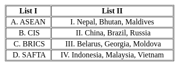
Match the List - I with List - II and select the correct answer from the code given below :

Detailed Solution for UGC NET Paper 2 Geography Mock Test - 2 - Question 7
  • The Primary activities are dependent totally on the nature and natural resources. This includes agriculture, mining, quarrying, fishing, etc.
  • The secondary economic activities process and produce finished output from the natural resources or raw materials from primary activities. These include factories of different kinds like metal and food processing.
  • The tertiary activities are activities that contribute to transport of the goods and services produced by secondary sector. This is service sector which includes activities like transport, tourism, etc.
  • Quaternary activities are based on skills of people. It includes knowledge-oriented activities like business consultancy, information technology, media, etc.

Thus, the correct answer is A.

UGC NET Paper 2 Geography Mock Test - 2 - Question 8

Which of the following is a warm ocean current?

Detailed Solution for UGC NET Paper 2 Geography Mock Test - 2 - Question 8
  1. North Equatorial Current: This is a warm ocean current that flows westward from the west coast of Africa towards the east coast of South America, driven by trade winds. It is part of the large-scale ocean circulation pattern near the equator, where waters are generally warmer.

  2. Gulf Stream: This is also a warm ocean current that originates from the North Equatorial Current. As it reaches the east coast of South America, it is deflected northward along the western North Atlantic, becoming the Gulf Stream. The Gulf Stream is a significant warm current that affects the climate of the east coast of North America, contributing to warmer temperatures and increased rainfall.

  3. Peru Current: This is a cold ocean current, not mentioned in the passage but known as the Humboldt Current, which flows along the west coast of South America from the south towards the equator. It brings cold water up from the depths, making it a cold current.

  4. North Atlantic Drift: This is another warm current that is a continuation of the Gulf Stream. After the Gulf Stream moves northward, it drifts eastward across the North Atlantic Ocean towards Europe, carrying warm water and affecting the climate of Western Europe.

Conclusion:

  • The Gulf Stream is clearly identified as a warm ocean current in the passage, making it the correct answer.
  • The North Equatorial Current and North Atlantic Drift are also warm currents, but the specific mention and detailed role of the Gulf Stream in the passage confirm it as the primary example of a warm ocean current.

The correct answer is 2. Gulf Stream.

UGC NET Paper 2 Geography Mock Test - 2 - Question 9

With reference to the water on the planet Earth, consider the following statements :

1. The amount of water in the rivers and lakes is more than the amount of groundwater.

2. The amount of water in polar ice caps and glaciers is more than the amount of groundwater.

Which of the statements given above is/are correct ?

Detailed Solution for UGC NET Paper 2 Geography Mock Test - 2 - Question 9

The correct answer is 2 only.

Key Points

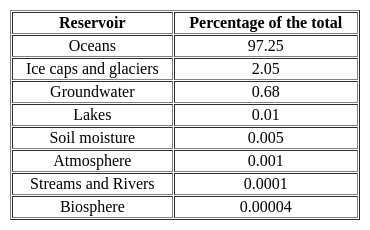
  • Distribution of water on the surface of the earth:
  • Water in groundwater is 0.62% while in lakes and rivers it is 0.008 (Salt lakes)+0.009(freshwater lakes) + 0.0001(rivers)=0.0171. Hence, statement 1 is not correct.
  • Water in polar ice caps and glaciers is 2% while in groundwater it is 0.62%. Hence, statement 2 is correct.
UGC NET Paper 2 Geography Mock Test - 2 - Question 10
The accumulation of depression in a river channel or on a continental shelf that is potentially dangerous to ships is called:
Detailed Solution for UGC NET Paper 2 Geography Mock Test - 2 - Question 10

The correct answer is Shoal

Key Points

  • Shoal is the accumulation of sediment in a river channel or on a continental shelf that is potentially dangerous to ships.
  • Shoals appear as long and narrow ridges.
  • The landform occurs when an ocean current, stream, or river facilitates the deposition of granular material and sediment leading to localized shallowing of the water.
  • Shoals can form as fluvial landforms in lakes, rivers, and streams or as an ocean bank in the sea.
Additional Information

Coral Atoll :

  • An atoll is a ring-shaped coral reef, island, or series of islets.
  • An atoll surrounds a body of water called a lagoon.
  • Atolls develop with underwater volcanoes, called seamounts.

Coast :

  • Coast is also called shore and is a broad area of land that borders the sea.
  • The boundary of a coast, where land meets water, is called the coastline.
  • Because coasts are dynamic or constantly changing, they are important ecosystems.
  • They provide unique homes for marine plants, animals, and insects.
UGC NET Paper 2 Geography Mock Test - 2 - Question 11
In July, Inter Tropical Convergence Zone (ITCZ) is located around
Detailed Solution for UGC NET Paper 2 Geography Mock Test - 2 - Question 11

The correct answer is 20° N to 25° N latitudes.

Key Points

  • The Inter-Tropical Convergence Zone, or ITCZ, is the region that orbits Earth, near the equator, where the northern and southern hemisphere trade winds converge.
  • In January the ITCZ ​​is located at approximately 15°S.
  • In July it is situated at 20°N to 25°N.

Important Points

  • The Intertropical Convergence Zone (ITCZ) is a low-pressure area located on the equator.
  • Trade winds are found in this region.
  • So the air starts rising in this area.
  • I.T.C.Z in the month of July. 20° to 25°N.
  • It is situated in the Gangetic plain around the latitudes.
  • Sometimes called a monsoon trough, this monsoon trough encourages the development of thermal low air pressure over north and north-west India.
  • Due to the northward movement of ITCZ, the trade winds of the southern hemisphere cross the equator between 40° and 60° East longitude.
  • Under the influence of the Coriolis force, the direction of these trade winds crossing the equator becomes from southwest to northeast.
UGC NET Paper 2 Geography Mock Test - 2 - Question 12

Consider the following statements about Equator and choose the correct option:

(A) The equator is a real line running on the globe, which divides it into two equal parts.

(B) The equator is the longest latitude.

(C) The equator represents the 180° latitude.

Detailed Solution for UGC NET Paper 2 Geography Mock Test - 2 - Question 12

The correct option is: Only (B)are true.
Important Points

(A)The equator is a real line running on the globe, which divides it into two equal parts.

  • The statement is incorrect.
  • The equator is an imaginary line running horizontally around the Earth, dividing it into the Northern Hemisphere and the Southern Hemisphere.
  • It is not a real physical line on the Earth's surface.

(B) The equator is the longest latitude.

  • The statement is true.
  • The equator is the longest latitude line. It is the largest circle of latitude, measuring approximately 40,075 kilometers or 24,901 miles in length.

(C) The equator represents the 180° latitude.

  • The statement is incorrect.
  • The Equator represents 0° latitude.
  • It is the imaginary line that equally divides the Northern and Southern Hemispheres.
  • Latitude lines are measured from the Equator, with values increasing up to 90° north at the North Pole and 90° south at the South Pole.
  • The 180° line you may be thinking of is the 180° longitude line, which is part of the system used to divide the Eastern and Western Hemispheres.
UGC NET Paper 2 Geography Mock Test - 2 - Question 13
This cold ocean current is of low salinity and flows in the South Pacific region. Flowing along the west coast of South America, it acts as a major nutrient source for the marine ecosystem. Which of the following ocean currents best match with the features described above?
Detailed Solution for UGC NET Paper 2 Geography Mock Test - 2 - Question 13

Hence Option C is the correct answer.

UGC NET Paper 2 Geography Mock Test - 2 - Question 14

Consider the following statements about insolation and choose the correct option.

(A) Insolation is the incoming solar energy intercepted by the earth

(B) The amount and the intensity of the insolation vary during a day, in a second and in a year

(C) The amount of insolation increases from the equator towards the poles

Detailed Solution for UGC NET Paper 2 Geography Mock Test - 2 - Question 14

The correct answer is Only (A) and (B) are true.

Key Points: PointsThe question is about insolation, which is the incoming solar energy the Earth intercepts.

  • Option 1 is the correct answer, as statements (A) and (B) are true.
  • Statement (A) is true as insolation is the incoming solar energy the earth intercepts.
  • Statement (B) is also true as the amount and intensity of insolation vary during a day, in a second, and in a year.
  • These variations are due to factors such as the sun's angle, the atmosphere's thickness, and the earth's rotation and revolution.
  • Option 2 is incorrect as statement (A) is true, but statement (C) is false.
  • The amount of insolation actually decreases from the equator towards the poles.
  • Option 3 is incorrect as statement (B) is true, but statement (C) is false.
  • Option 4 is incorrect as all three statements are true, not false.

Additional Information

  • Insolation is an important factor that affects climate, weather, and ecosystems.
  • The variations in insolation can cause differences in temperature, pressure, wind, and precipitation patterns.
  • The equator receives more insolation than the poles because the sun's rays are more direct and spread over a smaller area.
  • The tilt of the earth's axis also affects the amount and distribution of insolation, leading to the seasons.
UGC NET Paper 2 Geography Mock Test - 2 - Question 15
There are four domains of the natural environment. Two are the Atmosphere and Biosphere. The other two are:
Detailed Solution for UGC NET Paper 2 Geography Mock Test - 2 - Question 15

The correct answer is Hydrosphere and Lithosphere.

Key Points

The question is about the four domains of the natural environment.

  • Option 2: Hydrosphere and Lithosphere is the correct answer.
    • Hydrosphere refers to all the water on Earth, including oceans, lakes, rivers, and groundwater.
    • The lithosphere refers to the solid part of Earth, including the crust, mantle, and core.
  • The Atmosphere refers to the layer of gases surrounding Earth, including the air we breathe.
  • The Biosphere refers to all living organisms and their interactions with the other domains.

Additional Information

  • Mesosphere is the layer of the Earth's atmosphere above the stratosphere and the thermosphere.
  • The stratosphere is the layer of the Earth's atmosphere above the troposphere and the mesosphere.
UGC NET Paper 2 Geography Mock Test - 2 - Question 16

Given below are two statements :

Assertion (A): According to the World Health Organization (WHO) in 1993, there were 16.5 million deaths due to infectious diseases worldwide.

Reason (R): Urbanisation without health planning leads to the spread of diseases.

Select from the codes given below:

Detailed Solution for UGC NET Paper 2 Geography Mock Test - 2 - Question 16

The correct answer is Both (A) and (R) are true but (R) is not the correct explanation of (A).

Key Points

  • According to the World Health Organization (WHO) in 1993, there were 16.5 million deaths due to infectious diseases worldwide.
    • Urbanisation without health planning leads to the spread of diseases.
    • Hence option 2 is correct.

Additional Information

  • The global population was 2.8 billion in 1955 and is 5.8 billion now.
    • It will increase by nearly 80 million people a year to reach about 8 billion by the year 2025.
  • In 1955, 68% of the global population lived in rural areas and 32% in urban areas.
    • In 1995 the ratio was 55% rural and 45% urban; by 2025 it will be 41% rural and 59% urban.
  • Every day in 1997, about 365 000 babies were born, and about 140 000 people died, giving a natural increase of about 220 000 people a day.
  • Today's population is made up of 613 million children under 5; 1.7 billion children and adolescents aged 5-19; 3.1 billion adults aged 20-64; and 390 million over 65.
  • The proportion of older people requiring support from adults of working age will increase from 10.5% in 1955 and 12.3% in 1995 to 17.2% in 2025.
  • In 1955, there were 12 people aged over 65 for every 100 aged under 20.
    • By 1995, the old/young ratio was 16/100; by 2025 it will be 31/100.
  • The proportion of young people under 20 years will fall from 40% now to 32% of the total population by 2025, despite reaching 2.6 billion - an actual increase of 252 million.
  • The number of people aged over 65 will rise from 390 million now to 800 million by 2025 - reaching 10% of the total population.
  • By 2025, increases of up to 300% of the older population are expected in many developing countries, especially in Latin America and Asia.
  • Globally, the population of children under 5 will grow by just 0.25% annually between 1995-2025, while the population over 65 years will grow by 2.6%.
  • The average number of babies per woman of child-bearing age was 5.0 in 1955, falling to 2.9 in 1995 and reaching 2.3 in 2025.
    • While only 3 countries were below the population replacement level of 2.1 babies in 1955, there will be 102 such countries by 2025.
UGC NET Paper 2 Geography Mock Test - 2 - Question 17
Which is not a characteristic of culture?
Detailed Solution for UGC NET Paper 2 Geography Mock Test - 2 - Question 17

The correct answer is Culture is hereditary.

Culture is an umbrella term that encompasses the social behavior, institutions, and norms found in human societies, as well as the knowledge, beliefs, arts, laws, customs, capabilities, and habits of the individuals in these groups. Culture often originated from or is attributed to a specific region or location.

Key Points

Culture has five basic characteristics: It is learned, shared, based on symbols, integrated, and dynamic. All cultures share these basic features-

  • Culture is learned. It is not biological, and hereditary; we do not inherit it. Much of learning culture is unconscious. We learn about culture from families, peers, institutions, and media. The process of learning culture is known as enculturation. While all humans have basic biological needs such as food, sleep, and sex, the way we fulfill those needs varies cross-culturally.
  • Culture is shared, Because we share culture with other members of our group, we can act in socially appropriate ways and predict how others will act. Despite the shared nature of culture, that does not mean that culture is homogenous (the same). The multiple cultural worlds that exist in any society are discussed in detail below.
  • Culture is based on symbols, A symbol is something that stands for something else. Symbols vary cross-culturally and are arbitrary. They only have meaning when people in a culture agree on their use. Language, money, and art are all symbols. Language is the most important symbolic component of culture.
  • Culture is integrated, This is known as holism or the interconnected parts of a culture. All aspects of a culture are related to one another and to truly understand a culture, one must learn about all its parts, not only a few.
  • Culture is dynamic. This simply means that cultures interact and change. Because most cultures are in contact with other cultures, they exchange ideas and symbols. All cultures change, otherwise, they would have problems adapting to changing environments. And because cultures are integrated, if one component in the system changes, the entire system must likely adjust.
UGC NET Paper 2 Geography Mock Test - 2 - Question 18
Slow bending, folding, warping, and fracturing are indicators of which one of the following processes?
Detailed Solution for UGC NET Paper 2 Geography Mock Test - 2 - Question 18

The correct answer is ​Diastrophism.

Key Points

  • Diastrophism
    • It refers to all processes that move, elevate, or deformation of the earth's crust due to dystrophic movements (deforming movements) such as folding, faulting, warping (bending or twisting of a large area), and fracturing. Hence, Statement 1 is correct.
    • Diastrophism encompasses all processes that move, elevate, or build-up sections of the earth's crust.
    • Diastrophic changes are slow and can last for thousands of years.
    • By the end of the nineteenth century, it was widely believed that the reason for folding and faults was lateral compression produced by the Earth's gradual cooling, which resulted in a decreasing Earth.
    • Eduard Suess proposed his eustatic hypothesis which formed the foundation for Chamberlin's explanation of diastrophism.
    • Suess stated his conviction that the rise and fall of sea levels could be mapped over the globe over geologic time.

Additional Information

  • Denudation
    • All the exogenic geomorphic processes are covered under the general term, denudation.
    • The word ‘denude’ means to strip off or uncover.
    • Weathering, mass wasting/movements, erosion, and transportation are included in denudation.
  • Endogenic forces or endogenetic forces
    • It is the pressure that originates inside the earth, therefore also called internal forces.
    • These internal forces lead to vertical and horizontal movements and result in subsidence, land upliftment, volcanism, faulting, folding, earthquakes, etc.
  • Mountain building
    • The term ‘orogeny was coined by the American geologist, G.K. Gilbert, in 1890 to describe the process of mountain building.
    • The term was originally used by Gilbert to describe the fold mountain belts of the Alps and the Rockies.
UGC NET Paper 2 Geography Mock Test - 2 - Question 19
The height of Tsunami’s wave depends upon _______.
Detailed Solution for UGC NET Paper 2 Geography Mock Test - 2 - Question 19

Explanation:

Tsunamis:

(i) Tsunamis, also known as seismic sea waves (mistakenly called “tidal waves”), are a series of enormous waves created by an underwater disturbance such as an earthquake, landslide, volcanic eruption, or meteorite. A tsunami can move hundreds of miles per hour in the open ocean and smash into land with waves as high as 100 feet or more.

(ii) From the area where the tsunami originates, waves travel outward in all directions. Once the wave approaches the shore, it builds in height. The topography of the coastline and the ocean floor will influence the size of the wave. There may be more than one wave and the succeeding one may be larger than the one before. That is why a small tsunami at one beach can be a giant wave a few miles away.

Additional InformationThe physics of a Tsunami:

(i) Tsunamis can have wavelengths ranging from 10 to 500 km and wave periods of up to an hour. As a result of their long wavelengths, tsunamis act as shallow-water waves.

(ii) A wave becomes a shallow-water wave when the wavelength is very large compared to the water depth. Shallow-water waves move at a speed, c, that is dependent upon the water depth and is given by the formula

c = √gH

where g is the acceleration due to gravity (= 9.8 m/s2) and H is the depth of water.

(ii) In the deep ocean, the typical water depth is around 4000 m, so a tsunami will therefore travel at around 200 m/s or more than 700 km/h.

UGC NET Paper 2 Geography Mock Test - 2 - Question 20

Given below are two statements, one is labelled as Assertion (A) and the other is labelled as Reason (R). Read the statements and choose the correct answer using the code given below.
Assertion (A) : Central Business District (CBD) of a city has high concentration of wholesale stores, offices and cultural and recreational activities.
Reason (R) : Prices and demand of real increases as distance towards CBD reduces.

Detailed Solution for UGC NET Paper 2 Geography Mock Test - 2 - Question 20

Key Points

Assertion (A): Central Business District (CBD) of a city has a high concentration of wholesale stores, offices, and cultural and recreational activities.

The concept of CBD:

  • The term Central Business District (CBD) is a widely used term in commercial real estate and is defined as the functional area of a city that has the maximum concentration of commercial, retail, and business centers.
  • Geographically, it coincides with the city center and is the focal point for the transportation networks of the city.
  • It has maximum urban density than other districts of the town and offers a healthy environment for carrying out various commercial activities.
  • Today, CBDs are a diverse region in metro cities that not only include retail spaces, commercial, offices, financial institutions, government centres, and medical centres, but also entertainment hubs, restaurants, hotels, and residential area

Hence, the assertion is correct.

Reason (R): Prices and demand of real increases as distance towards CBD reduces.

Price and demand relationship:

  • In ancient times, CBDs were the market squares where merchants and customers gathered to sell and buy things.
  • However, as cities evolved, land scarcity and increasing demand reduced horizontal expansions and gave way to vertical developments.
  • The relationship of land price and distance to CBD is significant and negative, which means indicating the decreasing of land price by increasing distance from the CBD.
  • Market price gives the same result as the appraised price which is the effect of distance on land values is significant and negative.

Hence, the reason is also correct.

Therefore, Both (A) and (R) are true and (R) is the correct explanation of (A).

UGC NET Paper 2 Geography Mock Test - 2 - Question 21
Which of the following pairs is not correctly matched?
Detailed Solution for UGC NET Paper 2 Geography Mock Test - 2 - Question 21

The correct answer is Bantu - Sahara.

Key Points

  • Bantu peoples, the approximately 85 million speakers of the more than 500 distinct languages of the Bantu subgroup of the Niger-Congo language family, occupying almost the entire southern projection of the African continent.
    • Bantu the largest African language family, spoken in much of Sub-Saharan Africa.

Additional Information

  • Fulani, a primarily Muslim people scattered throughout many parts of West Africa, from Lake Chad, in the east, to the Atlantic coast.
  • The Maasai are an indigenous ethnic group in East Africa of semi-nomadic people settled in Kenya and northern Tanzania.
  • Nuba, inhabitants of the Nuba Hills in the Kordofan region of central-southern Sudan.
    • Sudan is a country in North Africa.
UGC NET Paper 2 Geography Mock Test - 2 - Question 22
Which of the following are not correct about Neo-Determinism?
Detailed Solution for UGC NET Paper 2 Geography Mock Test - 2 - Question 22
Neo-Determinism
  • Australian geographer Griffith Taylor, in 1920 argued that the limit of agricultural settlements in Australia has been set by factors of the physical environment such as a distribution of rainfall. He further said that the best economic programme for a country to follow has in large part been determined by nature, and it is the geographer’s duty to interpret this programme.
  • Man is able to accelerate, slow, or stop the progress of a country’s regional development. But he should not, if he is wise, depart from directions as indicated by natural environment. He is like the traffic controller in a large city who alters the rate but not the direction of progress.
  • This theory is also called ‘’stop and go determinism’’.
  • It says that man follows nature’s plan only if he is wise, presuming he can act foolishly, which admits the possible contention that within broad limits set by the environment, man can choose at the very least. But wisdom and folly are human concepts. Nature knows nothing about them.
  • This theory says that in no environment are the possibilities limitless and for every choice a price must be paid. Man makes his choice and man himself judges its relative wisdom or folly by reference to goals he himself has established.
UGC NET Paper 2 Geography Mock Test - 2 - Question 23
Which of the following statements BEST reflects the overall view on these geostrategic theories?
Detailed Solution for UGC NET Paper 2 Geography Mock Test - 2 - Question 23

Answer: option 3.

The Heartland and Rimland theories have been seminal in the study of geopolitics, offering frameworks for understanding global power dynamics through geographical lenses. While each theory has its critics and limitations, especially in the context of contemporary technological and geopolitical developments, they continue to provide foundational perspectives for analyzing international relations.
Key Points
The Heartland and Rimland theories provide valuable but contrasting insights:
  • Both theories approach the concept of global dominance from different geographical standpoints, with the Heartland Theory focusing on the central Eurasian landmass and the Rimland Theory emphasizing the strategic importance of coastal areas.
  • Despite criticisms and evolving global contexts, both theories contribute to a more nuanced understanding of the interplay between geography and power.
  • They offer contrasting yet complementary perspectives, encouraging analysts to consider a broader range of factors when assessing geostrategic dynamics.
Additional Information
Both theories are completely outdated and have no relevance in the modern world:
  • This statement dismisses the foundational insights provided by both theories into the significance of geography in global politics.
  • While technological advancements and new geopolitical challenges may have altered the landscape since these theories were first proposed, the core idea that geography matters in international relations remains relevant.
  • Moreover, elements of these theories continue to inform strategic thinking and policy-making in various contexts.
The Rimland Theory offers a more accurate perspective than the Heartland Theory:
  • Declaring one theory as more universally accurate than the other oversimplifies the complexity of geopolitics.
  • Each theory provides perspectives that are valuable in different contexts, and their relevance can vary depending on the specific geopolitical situation being analyzed.
  • It is more productive to view them as complementary rather than in competition for accuracy.
The theories are useful for historical analysis but offer limited predictive power:
  • While it's true that the predictive power of these theories may be limited, especially in light of modern technological and international developments, this statement underestimates the continuing impact of geography on geopolitical strategies and decisions.
  • These theories are not only useful for understanding past geopolitical strategies but also for framing current issues in a broader geographical context.
  • The insight that geography plays a critical role in international relations remains pertinent.

Hence, option 3.The Heartland and Rimland theories provide valuable but contrasting insights is correct.

UGC NET Paper 2 Geography Mock Test - 2 - Question 24
The main difference between the Heartland and Rimland theories lies in:
Detailed Solution for UGC NET Paper 2 Geography Mock Test - 2 - Question 24

Answer: Option 1) Their emphasis on land versus sea power.

The Heartland and Rimland theories are two significant geopolitical concepts that have influenced international relations and strategic planning. Proposed by different scholars in the early to mid-20th century, these theories offer distinct perspectives on how geographical advantages could lead to global dominance. Understanding the core difference between them is crucial for grasping the historical and contemporary geopolitical landscape.
Key Points
Correct Option: Their emphasis on land versus sea power:
  • The Heartland Theory, proposed by Halford Mackinder, emphasizes the central importance of land power.
  • It argues that the nation that controls the central Eurasian plains (the "Heartland") could potentially achieve global domination, based on the premise that this area is strategically invulnerable and pivotal for controlling the World-Island (Eurasia and Africa).
  • The Rimland Theory, introduced by Nicholas Spykman, counters this by highlighting the significance of sea power.
  • It suggests that controlling the coastal areas or the "Rimland" that surrounds Eurasia is key to global supremacy.
  • Spykman believed that maritime mobility and control over these coastal states offered superior strategic advantages over the inland-centric approach of the Heartland Theory.
Additional Information
Their assessment of the importance of central location:
While both theories indeed consider geography's impact on power dynamics, they do not fundamentally differ in their assessment of the importance of a central location. Instead, they differ in what they consider the key area for control (central Eurasia vs. coastal regions).
Their predictions about the future of global power dynamics:
Both theories make predictions about the mechanisms of achieving global dominance but do not fundamentally differ in this aspect. The core difference is in the strategic emphasis (land power vs. sea power), not in the nature of their predictions per se.
Their origin and historical context:
Although both theories were proposed in different periods and contexts (Mackinder's Heartland Theory in the early 20th century and Spykman's Rimland Theory a few decades later), the fundamental difference between them is not derived from their origin or historical context. Instead, it's their strategic focus that distinguishes them.
Hence, option 1 is correct.
UGC NET Paper 2 Geography Mock Test - 2 - Question 25
Consider the following statements about Losch’s theory of industrial location and choose which amongst them is true:

i. Goods have high demand with low prices.

ii. The demand curve rotated round the production point to give shape.

iii. As the competition increases, the market areas becomes hexagonal.

Detailed Solution for UGC NET Paper 2 Geography Mock Test - 2 - Question 25

Losch’s theory attempts to explain the size and shape of market area within which a location would command the largest revenue. It is assumed that the demand varies inversely with price. This gives us a demand pattern. The demand curve can be rotated round the production point to give the size and shape of the market space. With increasing competition, the size of the market area becomes hexagonal. They also become smaller as the markets are competed away.

Thus, the Correct answer is D.

UGC NET Paper 2 Geography Mock Test - 2 - Question 26
Rate at which solar radiation is received outside the earth’s atmosphere on a surface perpendicular to sun’s rays, when the earth is an average distance is called?
Detailed Solution for UGC NET Paper 2 Geography Mock Test - 2 - Question 26

The amount of radiant energy has been found to be constant. There is little variation is the quantum of solar energy received at the outer margin of the atmosphere. It is a fact verified by observations made at various places on different occasions.

Thus, the Correct answer is B.

UGC NET Paper 2 Geography Mock Test - 2 - Question 27

Match List I with List II:- 

Detailed Solution for UGC NET Paper 2 Geography Mock Test - 2 - Question 27

Stream length ratio= Rl= Lu/Lu+i, where, Lu is the mean length of the streams or basins of order u; the suffix u+1 denotes the same for the next higher order.

Bifurcation Ratio, Rb= Nu/Nu+i, where Nu is the number of the streams or basin of order u; the suffix u+1 denotes the same for the next higher order.

Elongation ratio(Re)= P/π L

Where, P= basin perimeter, L is maximum basin length.

Drainage Texture may be defined as the total number of streams segments of all order in a basin per perimeter of the basin.

Thus, the Correct answer is d.

UGC NET Paper 2 Geography Mock Test - 2 - Question 28
Consider the following statements:-

a) Weber's assumptions of a perfect competition with the spatial framework of a society has been criticized by many.

b) According to Losch, firms tend to locate at the most profitable of the production points.

c) E M Hoover used Isotims for joining places of equal transport costs.

d) D M Smith utilized the least cost approach of Weber with some of monopolistic -market area approach of Losch.

Which of the following options are correct?

Detailed Solution for UGC NET Paper 2 Geography Mock Test - 2 - Question 28

Hoover proposed his theory of industrial location whose determinants of location of industries were transportation costs and extraction costs. The delivered price for the buyers will be the cost of extraction plus the transport costs. This was represented by isotims, which start from the point of production or extraction and joins the places containing the same delivered prices. Buyers will obtain the product from the source that offers the lowest delivered price.

UGC NET Paper 2 Geography Mock Test - 2 - Question 29
Read the following statements given below:

(a) Monsoon break is the phenomenon which means monsoon rainfall stops for a couple of days.

(b) Western Ghats receive orographic rain during the  monsoon.

(c) First rain in a place is called as monsoon burst.

(d) The El Nino current decreases the temperature of water.

Select the correct option:

Detailed Solution for UGC NET Paper 2 Geography Mock Test - 2 - Question 29

Western Ghats lie near the western coast of India. They occur as a hindrance for the winds of South-west monsoon winds and lead to orographic rain in the area. First occurrence of rain in an area is called as monsoon burst. During the Monsoon season, there are periods when there are sharp decrease in rainfall over most parts of the country, this is called monsoon break. The El Nino is a warm current and hence it leads to increase in temperatures by 3-4 degree Celsius.

UGC NET Paper 2 Geography Mock Test - 2 - Question 30

Jarawas and Sentinelese tribes are found in which among the following state / Union Territory of India?

Detailed Solution for UGC NET Paper 2 Geography Mock Test - 2 - Question 30

Andaman is home to five "particularly vulnerable" tribes. They are the Jarawas, North Sentinelese, Great Andamanese, Onge and Shompen. The Jarawas and the North Sentinelese haven't integrated with the mainstream population yet.

View more questions
Information about UGC NET Paper 2 Geography Mock Test - 2 Page
In this test you can find the Exam questions for UGC NET Paper 2 Geography Mock Test - 2 solved & explained in the simplest way possible. Besides giving Questions and answers for UGC NET Paper 2 Geography Mock Test - 2, EduRev gives you an ample number of Online tests for practice
Download as PDF