UGC NET Exam  >  UGC NET Tests  >  UGC NET Paper 2 Geography Mock Test - 8 - UGC NET MCQ

UGC NET Paper 2 Geography Mock Test - 8 - UGC NET MCQ


Test Description

30 Questions MCQ Test - UGC NET Paper 2 Geography Mock Test - 8

UGC NET Paper 2 Geography Mock Test - 8 for UGC NET 2024 is part of UGC NET preparation. The UGC NET Paper 2 Geography Mock Test - 8 questions and answers have been prepared according to the UGC NET exam syllabus.The UGC NET Paper 2 Geography Mock Test - 8 MCQs are made for UGC NET 2024 Exam. Find important definitions, questions, notes, meanings, examples, exercises, MCQs and online tests for UGC NET Paper 2 Geography Mock Test - 8 below.
Solutions of UGC NET Paper 2 Geography Mock Test - 8 questions in English are available as part of our course for UGC NET & UGC NET Paper 2 Geography Mock Test - 8 solutions in Hindi for UGC NET course. Download more important topics, notes, lectures and mock test series for UGC NET Exam by signing up for free. Attempt UGC NET Paper 2 Geography Mock Test - 8 | 100 questions in 120 minutes | Mock test for UGC NET preparation | Free important questions MCQ to study for UGC NET Exam | Download free PDF with solutions
UGC NET Paper 2 Geography Mock Test - 8 - Question 1

Which one of the following kinds of towns was not planned and developed during the British Rule in India?

Detailed Solution for UGC NET Paper 2 Geography Mock Test - 8 - Question 1

Cantonment Towns

  • The nature of the colonial city changed further in the mid-nineteenth century. After the Revolt of 1857 British attitudes in India were shaped by a constant fear of rebellion. They felt that towns needed to be better defended, and white people had to live in more secure and segregated enclaves, away from the threat of the “natives ”.
  • Pasturelands and agricultural fields around the older towns were cleared, and new urban spaces called “Civil Lines” were set up. White people began to live in the Civil Lines.
  • Cantonments– places where Indian troops under European command were stationed – were also developed as safe enclaves. These areas were separate from but attached to the Indian towns. With broad streets, bungalows set amidst large gardens, barracks, parade ground and church, they were meant as a safe haven for Europeans as well as a model of ordered urban life in contrast to the densely built up Indian towns.

Railway Colonies

  • The introduction of railways in 1853 meant a change in the fortunes of towns. Economic activity gradually shifted away from traditional towns which were located along old routes and rivers. Every railway station became a collection depot for raw materials and a distribution point for imported goods.
  • With the expansion of the railway network, railway workshops and railway colonies were established. Railway towns like Jamalpur, Waltair and Bareilly developed.

Hill Stations

  • As in the case of cantonments, hill stations were a distinctive feature of colonial urban development. The founding and settling of hill stations was initially connected with the needs of the British army.
  • Simla (present-day Shimla) was founded during the course of the Gurkha War (1815-16); the Anglo-Maratha War of 1818 led to British interest in Mount Abu; and Darjeeling was wrested from the rulers of Sikkim in 1835.
  • Hill stations became strategic places for billeting troops, guarding frontiers and launching campaigns against enemy rulers.
UGC NET Paper 2 Geography Mock Test - 8 - Question 2

The social theory that appeared as the sequel to Behaviouralism is

Detailed Solution for UGC NET Paper 2 Geography Mock Test - 8 - Question 2

Correct Answer: Game theory.

Key Points

  • Game theory is a theory of social interaction, which attempts to explain the interaction people have with one another. As the name of the theory suggests, game theory sees human interaction as just that: a game.
  • It was initially developed to understand a large variety of economic behaviors, including the behavior of firms, markets, and consumers.
  • The use of the game theory has since expanded in the social sciences and has been applied to political, sociological, and psychological behaviors as well.
  • Game theory was first used to describe and model how human populations behave and, Game the social theory that appeared as the sequel to Behaviouralism.
  • Some scholars believe that they can predict how actual human populations will behave when confronted with situations analogous to the game being studied.

​ Additional Information

  • Behaviorism focuses on the idea that all behaviors are learned through interaction with the environment. This learning theory states that behaviors are learned from the environment, and says that innate or inherited factors have very little influence on behavior.
  • The radical approach to geography developed in the 1970s as a reaction to ‘quantitative revolution’ and positivism which tried to make geography a spatial science, with great emphasis on locational analysis. It began as a critique within the contemporary liberal capitalistic society but later coalesced around a belief in the power of Marxian analysis.
  • Structuralism is an approach within geography that is characterized by the fact that the belief that to understand the surface patterns of human behavior, it is necessary to know the structures underlying them which produce or shape human actions.
  • Feminism is a broad, complex, contested term that comprises both an intellectual and a political project that seeks to identify, understand, and dismantle inequalities between men and women.


1 Crore+ students have signed up on EduRev. Have you? Download the App
UGC NET Paper 2 Geography Mock Test - 8 - Question 3

Which function of total station is used to determine the heights of inaccessible points where it is not possible to locate the prism?

Detailed Solution for UGC NET Paper 2 Geography Mock Test - 8 - Question 3

Explanation:

  • Total station is a combination of an electronic theodolite and an electronic distance meter (EDM).
  • The combination makes it possible to determine the coordinates of a reflector by aligning the instrument cross-hairs on the reflector.
  • A microprocessor in the instrument take care of the recordings, readings, and other computations.
  • Remote elevation function of total station is used to determine the heights of inaccessible points where it is not possible to locate the prism.         

     Uses of Total Station:

  • It is a combination of electronic theodolite for measuring horizontal and vertical angles.
  • Distance between any two points and Elevation of objects can be measured. 
  • All three coordinates of the observed points can be measured.
UGC NET Paper 2 Geography Mock Test - 8 - Question 4
Which union territory of India had the lowest sex ratio in 2011?
Detailed Solution for UGC NET Paper 2 Geography Mock Test - 8 - Question 4

The correct answer is Daman and Diu.

Key Points 

  • The Sex ratio is used to describe the number of females per 1000 males.
  • It is a valuable source for finding the population of women in India and what is the ratio of women to that of men in India.
  • In the Population Census of 2011, it was revealed that the population ratio in India is 943 females per 1000 males.
  • The Sex Ratio 2011 shows an upward trend from the census 2011 data.
  • Considering all Union Territories and States, as per the 2011 census, Daman and Diu have the lowest sex ratio of 618 and Kerala has the highest sex ratio of 1084. 

Additional Information

Census 2011:

  • It is the 15th National Census Survey conducted by the Census Organization of India.
  • Shri C. Chandramouli is the Commissioner and Registrar General of the Census of India 2011.
  • As per the Census of India 2011, the population density of India was 382 per square km.
  • The Indian Census is the most credible source of information on Demography (Population characteristics), Economic Activity, Literacy and Education, Housing Household Amenities, Urbanisation, Fertility, Mortality, etc.
  • Census was introduced in India during the era of Lord Mayo in the year 1872. It came into force in 1881.
  • The slogan of census 2011 was 'Our Census, Our future'.
  • The population of the nation as per the provisional figures of Census 2011 was 1210.19 million of which 623.7 million (51.54%) were males and 586.46 million (48.46%) were females. Uttar Pradesh is the most populous state in India its population is more than the population of Brazil.
UGC NET Paper 2 Geography Mock Test - 8 - Question 5

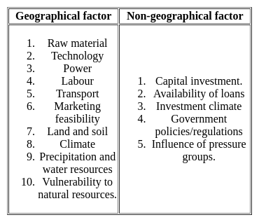
Which one of the following is not a geographical factor favorable for the location of an industry?

Detailed Solution for UGC NET Paper 2 Geography Mock Test - 8 - Question 5

The correct answer is Capital Investment.

Key Points

  • Industrial locations are complex in nature. These are influenced by the availability of many factors.  All the factors can be broadly categorized in two,

Additional Information

  1. Geographical factors: the geographical factors are related to the earth's surface features. Such as the arrangement of physical features, climate, soil, vegetation, locational features.
  2. Non-locational features: these features are not directly dependent on the geography of the area. It is something related to the partial factors but really important for the establishment of an industry. For example, capital, govt. policies, etc.

Hence, option 1 is the correct answer.

Important Point

Capital investment:

  • Capital or investment is the basic requirement for the establishment of a manufacturing unit.
  • The amount of financial investment discerns the magnitude or scale of the unit.
  • In the modern manufacturing world, not only the product but its marketing also need tremendous capital investment.
  • The role of financial institutions like banks and insurance is increasing day by day.
  • The huge money requirement needs capital accumulation from financial agencies, state governments, and even from people is a regular practice.
UGC NET Paper 2 Geography Mock Test - 8 - Question 6

Which of the following is not associated with political Geography

A) I. Bowman

B) R. Johnson

C) F. Ratzel

D) H. J. Mackinder

Choose the correct answer from the options given below:

Detailed Solution for UGC NET Paper 2 Geography Mock Test - 8 - Question 6

R. Johnson is not associated with political Geography.

Important Points

R. Johnson:

  • He is associated with the study of coastal morphology.
  • He recognizes the concept of shoreline zones.

Additional Information

  • Isaiah Bowman was an American geographer and President of Johns Hopkins University, 1935–1948. He was Political geographer of the past. 
  • Friedrich Ratzel was a German geographer and ethnographer, notable for first using the term Lebensraum ("living space") in the sense that the National Socialists later would.
  • Halford Mackinder, a British political geographer noted for his work as an educator and for his geopolitical conception of the globe as divided into two camps, the ascendant Eurasian “heartland” and the subordinate “maritime lands,” including the other continents. He was knighted in 1920.
UGC NET Paper 2 Geography Mock Test - 8 - Question 7

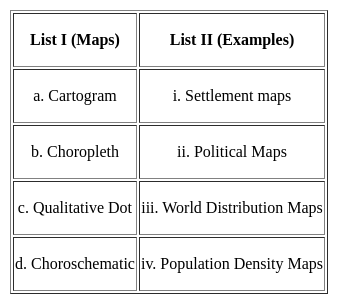
Match List I with List II:-

Detailed Solution for UGC NET Paper 2 Geography Mock Test - 8 - Question 7
  • Cartograms are representations of statistical data on a map in a diagrammatic way by purposefully distorting the original shape and appearance of the area concerned. World Distribution map is an example of a cartogram.
  • In choropleth maps, the density of population, location factor for industries or the spatial distribution of the intensity or the density of an element is shown with the help of a system of graded shading or color, drawn following the boundaries of administrative units.
  • In Quantitative dot maps, quantities or values are represented by dots of uniform sizes, each dot having a specific value. These are useful when the values are unevenly and sporadically distributed. Settlement maps show these characteristics.
  • The spatial distribution of data is shown by a uniform scheme such as using letters, symbols, numbers, shapes, roman numerical in Choroschematic maps. e.g. the political maps are an example of choroschematic maps since various symbols are used for describing the political boundaries, districts, etc.

Thus, the Correct answer is C.

UGC NET Paper 2 Geography Mock Test - 8 - Question 8
Which state has the largest tribal population according to the census of 2011?
Detailed Solution for UGC NET Paper 2 Geography Mock Test - 8 - Question 8

 The state of Madhya Pradesh has tribal population of 1,53,16,784. This number is nearly 21.1% of the total population of the state. The tribes here include Gond, Mina, Oraon, Munda, Kol, Kawar, Korku, Habla, Saharia tribes among others. The states of Mahrashtra, Meghalaya and Mizoram have tribal population of 10510213, 2555861 and 1036115 respectively.

Thus, the correct answer is C.

UGC NET Paper 2 Geography Mock Test - 8 - Question 9

For cotton cultivation which among the following soils is considered most suitable?
Detailed Solution for UGC NET Paper 2 Geography Mock Test - 8 - Question 9

For cotton cultivation Black Soil is considered most suitable.

Thus, the correct answer is B.

UGC NET Paper 2 Geography Mock Test - 8 - Question 10
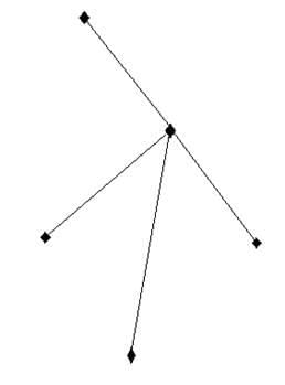
Calculate the Beta index of the following figure

Detailed Solution for UGC NET Paper 2 Geography Mock Test - 8 - Question 10

The beta index is the level of connectivity in a given network. The beta index is calculated with the formula,

β=e/v

where ‘e’ is no. of edges or links and ‘v’ is the no of nodes. In the given figure, edges are 4 and nodes are 5. Thus, the beta index is

4/5=0.8

Thus, the correct answer is A.

UGC NET Paper 2 Geography Mock Test - 8 - Question 11
The Peru-Chile Trench has been formed due to
Detailed Solution for UGC NET Paper 2 Geography Mock Test - 8 - Question 11

The Convergence of plates or convergent boundaries refer to the situation where two plates moving from opposite directions come closer to each other. The Peru-Chile trench has been formed due to the convergence of the Nazca Oceanic plate and the South American continental plate. Here subduction of plates is a common thing and is a supporting reason for the formation of trenches.

UGC NET Paper 2 Geography Mock Test - 8 - Question 12
Which of the following are the main Objectives of the Agro-climatic zones?

a) To optimise agricultural production

b) To increase farm income

c) To generate more employment

Choose the correct option:

Detailed Solution for UGC NET Paper 2 Geography Mock Test - 8 - Question 12

All three options are the primary objectives of the Agro-climatic regions. However, according to the Planning Commission of India, the primary objective of the Agro-climatic regions is:- 1. maximise the net income of the producers, 2. attempt a broad demand-supply balance of major commodities at the national level, 3. provide a framework for scientific and sustainable use of natural resources, particularly land, water and forests in the long run.

UGC NET Paper 2 Geography Mock Test - 8 - Question 13

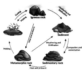
Consider the following statements regarding types of rocks:

1. In general, metallic minerals are found in igneous and metamorphic rock.

2. Igneous and metamorphic rock forms large plateaus.

3. Coal and Petroleum are found in the sedimentary strata.

Select the correct answer using the code given below.

Detailed Solution for UGC NET Paper 2 Geography Mock Test - 8 - Question 13

The correct answer is 1, 2 and 3Key Points 

  • Minerals occur in different types of rocks such as Igneous Rocks, Metamorphic Rocks and Sedimentary Rocks.

Metamorphic Rocks:

  • They are formed from other rocks that are changed by heat and pressure underground.
  • Some examples of metamorphic rocks are: 
    • gneissslatemarbleschist and quartzite.
  • It is formed when existing rock is transformed physically or chemically at elevated temperatures, without actually melting to any great degree.
  • Metallic Minerals found in igneous and metamorphic rock:
    •  Iron ore in north Sweden, Copper and Nickel deposits in Ontario, Canada, iron, nickel, chromites and platinum in South Africa. Hence Statement 1 is correct.
  • Igneous and metamorphic rock forms large plateaus as they are more stable. Hence Statement 2 is correct.

Sedimentary Rocks:

  • Sedimentary rocks are type of rock that are formed by the accumulation or deposition of mineral or organic particles at the Earth's surface, followed by cementation.
  • Sedimentary rocks are formed from layers of sand, silt, dead plants, and animal skeletons.
  • Common sedimentary rocks include sandstonelimestone and shale.
  • Sedimentary rocks are deposited in layers as strata, forming a structure called Bedding.
  • Sedimentary rock formations of plains and young fold mountains contain non-metallic minerals like limestone.
  • Coal and Petroleum are found in the sedimentary strata. Hence Statement 3 is correct.

Additional Information

Igneous Rocks:

  • Igneous rocks are formed from melted rock deep inside the Earth.
  • Most of the Earth's oceanic crust is made of igneous rock.
  • Igneous rock is formed through the cooling and solidification of magma or lava.
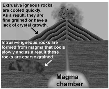
  • Solidification into rock occurs either:
    • Intrusive Rocks: formed below the surface of the earth
    • Extrusive Rocks: formed on the surface of the earth
  • Igneous rock may form with crystallization to form granular, crystalline rocks, or without crystallization to form natural glasses.
  • Some examples of igneous rocks are Granite, Basalt and Pumice.

UGC NET Paper 2 Geography Mock Test - 8 - Question 14
The principle of GPS positioning is:
Detailed Solution for UGC NET Paper 2 Geography Mock Test - 8 - Question 14

Explanation:

GPS:

  • The Global Positioning System (GPS) is a satellite-based navigation and surveying system for the determination of precise position and time, using radio signals from the satellites, in real-time or in post-processing mode.
  • GPS is being used all over the world for numerous navigational and positioning applications, including navigation on land, in the air and at sea, determining the precise coordinates of important geographical features as an essential input to mapping and Geographical Information systems (GIS), along with its use for precise cadastral surveys, vehicle guidance in cities and on highways using GPS-GIS integrated systems, earthquake and landslide monitoring, etc.

GPS Positioning:

  • GPS is a constellation of 24 or more satellites flying 20,350 km above the surface of the earth. Each one circle the planet twice a day in one of six orbits to provide continuous, worldwide coverage.
  • The absolute coordinates of the antenna position (centered over the survey station) are determined using a single GPS receiver, by a method similar to the resection method used in plane tabling.

How GPS Works:

  1. GPS satellites broadcast radio signals providing their locations, status, and precise time (t1) from onboard atomic clocks.
  2. The GPS radio signals travel through space at the speed of light (c), more than 299,792 km/second.
  3. GPS device receives the radio signals, noting their exact time of arrival (t2), and uses these to calculate its distance from each satellite in view.
  4. Once a GPS device knows its distance from at least four satellites, it can use geometry to determine its location on Earth in three dimensions
UGC NET Paper 2 Geography Mock Test - 8 - Question 15

Identify the theories/hypotheses that have been put forward to explain the causes of mountain building.

(A) Nebular Hypothesis

(B) Progressive Wave Theory

(C) Contraction Hypothesis

(D) Plate Tectonics Theory

Choose the most appropriate answer from the options given below:
Detailed Solution for UGC NET Paper 2 Geography Mock Test - 8 - Question 15

Correct Answer: (C) and (D) only.

Key Points

Contraction Hypothesis:

  • H. Jeffreys has presented a detailed discussion of his thermal contraction theory in his famous book, The Earth: Its origin history and physical constitution. Jeffreys is a contraction and seeks an explanation for mountain building within the framework of contraction produced by the loss of heat in the earth’s crust.
  • According to Jeffrey’s calculations, there has been no change in temperature in the interior of the earth, i.e., in the zone from the center of the earth to about 700 km below the earth’s surface. But the uppermost 700 km thick layer has experienced a temperature decrease. In these upper parts, every successive layer cools more rapidly than the layer below it, and, therefore, the upper layers have suffered more contraction than the lower layers.
  • In fact, the hot and less contracting lower layer obstructs and retards the contraction of the upper layer, with the result that the upper layer can contract only by spreading out and thinning itself. The solidified uppermost layer can cool only up to a certain point through this process and therefore its contraction also stops. But the cooling and contraction of the underlying layer continue. The result is that the upper layer becomes larger in comparison to the lower contracting layer, and does not fit in with the underlying layer. In its effort to adjust itself to the contracting lower layer, the upper layer undergoes compression which produces folding and faulting. In other words, the upper layer undergoes crustal shortening.
  • On the other hand, the contracting lower crustal layer becomes smaller than the hot interior and does not fit in with the latter and the former has to spread or stretch itself to conform to the internal layer. This generates tension, resulting in the formation of fissures and cracks. These fissures and cracks get filled up with the hot and molten material from below. In between the upper zone of compression and the lower zone of tension, there should be an intermediate zone where the contraction is such that it is able to adjust itself to the lower contracting crustal layer. This intermediate zone is a level of no strain. As the earth has gone on cooling, the level of no strain has been sliding downwards from the earth’s surface. Above this level, on account of the horizontal compressive stress, there is buckling and folding, and the formation of mountains.

Plate Tectonics Theory:

  • The theory of plate tectonic as outlined by. Hess and R. Dietz and postulated by W. J. Morgan is the most modern, most scientific, and most acceptable theory. It explains the origin of mountains in a scientific manner with the mechanism of plate movements. It recognizes three types of plate boundaries.
  • The divergent and the convergent boundaries are particularly important because oceanic ridges and rift valleys are formed on the divergent boundaries, and the folded mountain ranges are built on the convergent boundaries.
  • The young folded mountains of the world-the Alps, the Himalayan mountain system as well as the Circum Pacific belt of mountains are located on convergent plate boundaries where there is a state of collision between two plates. It may therefore be stated as a general rule that where there is convergence or collision of two plates, mountains are formed as a result of compression in the earth’s crust. The Convergence of plates is possible under three different conditions.
  • collision between a continental and an oceanic plate or continent-ocean collision. The collision between two continental plates or continent-continent collision, and the collision between two oceanic plates or ocean-ocean collision.

Additional Information

  • The nebular hypothesis is the most widely accepted model in the field of cosmogony to explain the formation and evolution of the Solar System. It suggests the Solar System is formed from gas and dust orbiting the Sun.
  • The progressive wave theory regarding tides was put forth by William Whewell.
UGC NET Paper 2 Geography Mock Test - 8 - Question 16

Direction: The following item consists of two statements, statement 1 and statement 2. Examine these two statements carefully and select the correct answer from the code given below.

Statement 1:

The salinity of oceans is relatively higher near the equator than in other regions.

Statement 2:

The Equator region has heavy rainfall, high relative humidity and calm air.

Detailed Solution for UGC NET Paper 2 Geography Mock Test - 8 - Question 16

The correct answer is Option 4 is correct.

Key Points

  • Generally, salinity decreases from the equator towards the pole but the highest salinity is seldom recorded near the tropics (30° N and 20° W - 60° W).
  • Near the equator, there is heavy rainfall, high relative humidity, cloudiness, and calm air of the doldrums.
  • The maximum oceanic salinity (37ppt) is observed between 20° N and 30° N and 20° W - 60° W. It gradually decreases towards the north. Hence, Statement 1 is not correct
  • The polar areas experience very little evaporation and receive large amounts of fresh water from the melting of ice. This leads to low levels of salinity, ranging between 20ppt and 32ppt.
  • One needs to understand here that statement first is correct.
  • On average, salinity decreases from the equator towards the poles.
  • However, it is important to note that the highest salinity is seldom recorded near the equator though this zone records high temperature and evaporation high rainfall reduces the relative proportion of salt. Thus, the equator accounts for only 35‰ salinity.
  • If we talk about the statement of Reason- it is incorrect because Salinity further decreases in the polar zones because of the influx of Glacial melt-water.
UGC NET Paper 2 Geography Mock Test - 8 - Question 17

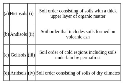
Match the following soil orders with their descriptions:
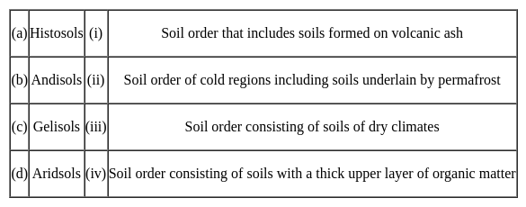

Choose the correct option from those given below:

Detailed Solution for UGC NET Paper 2 Geography Mock Test - 8 - Question 17

The recent system of Soil classification which is being used in India has been developed in U.S.A after it was passed through various stages and the last one is 7th approximation (Soil Survey Staff, 1960). Later this system of soil classification was published as USDA soil Taxonomy which has been modified a number of times and recently it has been further modified and improved in 1998(Soil Survey Staff, 1998)

1) Histosols

  • Histosols account for 10% of the land area.
  • These are soils that are mainly composed of organic materials.
  • Its key property is the presence of a large number of organic materials.
  • The organic deposit range between 147 and 180 cm and organic carbon level between 32 and 54 %.
  • The proportion of 70 % of histosols occurs in the frigid northern zone.

2) Andisols

  • Andisols are mostly formed by the weathering products of volcanic rocks, are able to store organic carbon at a considerably high proportion compared to other types of soils.
  • Andisols contribute to only 0.8% of the ice-free surface on our planet. Yet, due to their average 8-12% Organic carbon content, they are able to sequester more than 1.8% of the soil carbon stock globally. And this nature of volcanic soils is well documented and is associated with their relatively higher content of poorly crystalline mineral.

3) Gelisols:

  • Frost Churning(cryoturbation) plays a critical role in the formation of this soils it is done through ground patterning, the sequestration of organic matter below the soil surface, and alterations to the physical structure of soil materials.
  • Additionally, the Turbel suborder and Turbic subgroups of other suborders are defined by the presence of cryoturbated horizons and gelic materials, which "are manifested by involuted, irregular, or broken horizons, organic matter near or within the permafrost table, oriented rock fragments, and silt enriched layers.

4) Aridsols

  • Aridsols are the soil of the dry region.
  • These are found at much higher under humid climatic conditions than under arid climatic conditions.
  • Aridsols have a very low level of organic matter. As a result, It lacks vegetative production due to its dry nature.

Hence,

UGC NET Paper 2 Geography Mock Test - 8 - Question 18
The task of unit planning begins with the formation of appropriate units out of the prescribed course material. Which of the following subjects cannot be combined into a single unit called "Natural Resources of India"?
Detailed Solution for UGC NET Paper 2 Geography Mock Test - 8 - Question 18

Resources that are drawn from Nature and used without much modification are called natural resources. The air we breathe, the water in our rivers and lakes, the soils, minerals are all natural resources.Key PointsWater Resources, Land resources, mineral Resources, and India's Forest Resources can be combined into a single unit called "Natural Resources of India" because all these are resources that get directly from nature. Many of the resources are free gifts of nature and can be used directly, Such as-

  • Land resources: India covers an area of 32,87,263 sq km. According to area size, it is the seventh-largest country in the world after Russia, Canada, China, the U.S.A., Brazil, and Egypt. This vast size itself is the most important resource. About 30 percent of the area is covered by the mountains which are a source of scenic beauty, perennial rivers, home of forests and wildlife
  • Forest resources: Forests are our treasures which provide us a wide variety of commodities such as timber, fuel wood, fodder, fiber, fruits, herbal drugs, cosmetics, and many types of raw materials used by the industries. A great variety of mammals and birds which live in the forests, serve as useful living resources. Forests play a great role in soil formation, water conservation, and regeneration of oxygen.
  • Water resources: India is fortunate to have large water resources. Diversity in resources is the result of diversity in landforms in the form of glaciers, surface rivers, underground water, rains, and oceans.
  • Mineral resources: India is very rich in mineral resources and has the potential to become an industrial power. It possesses large reserves of iron ore, extensive deposits of coal, and mineral oil, and rich deposits of bauxite and mica.

Hence modern resources of communication cannot be combined into a single unit called "Natural Resources of India.

Hint

  • Modern Resources of communication can't be included in the unit of natural resources because modern resources of communication are mostly manmade and are not obtained from nature freely.
UGC NET Paper 2 Geography Mock Test - 8 - Question 19
Which of the following is NOT an essential characteristic of ecological succession?
Detailed Solution for UGC NET Paper 2 Geography Mock Test - 8 - Question 19

Answer: Option 4) Static and unchanging nature of communities

Ecological succession is a natural process that describes the gradual and predictable changes in the composition of species in a community over time. It is characterized by the sequential replacement of one community by another until a stable climax community is established.

Key Points
Essential Characteristics of Ecological Succession:
  • Orderly and sequential change in communities: Ecological succession is a gradual and orderly process, where each stage prepares the environment for the next stage.
  • Replacement of one community by another: Succession involves the gradual replacement of one community by another, as species adapt and compete for resources.
  • Development of a stable climax community: Succession ultimately leads to the establishment of a stable climax community, which is adapted to the specific environmental conditions.
Non-Essential Characteristic:
  • Static and unchanging nature of communities: This statement is not an essential characteristic of ecological succession. Ecological communities are dynamic and undergo constant change in response to environmental factors, disturbances, and species interactions.
Additional Information
Orderly and sequential change in communities: This is an essential characteristic of ecological succession, as it describes the gradual and predictable changes in the composition of species over time.
Replacement of one community by another: This is also an essential characteristic of ecological succession, as it involves the gradual replacement of one community by another, as species adapt and compete for resources.
Development of a stable climax community: This is an essential characteristic of ecological succession, as it ultimately leads to the establishment of a stable climax community, which is adapted to the specific environmental conditions.
Therefore, among the given options, option 4) Static and unchanging nature of communities is not an essential characteristic of ecological succession.
Important Points
  • The rate and direction of ecological succession can be influenced by various factors, such as climate, soil conditions, disturbances, and the availability of resources.
  • Understanding ecological succession is important for managing and conserving ecosystems, as it helps us predict how communities will respond to environmental changes and disturbances.
UGC NET Paper 2 Geography Mock Test - 8 - Question 20

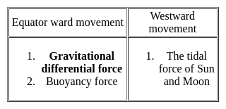
Which of the following statements are correct about the continental drift theory?

1. Wegner aims to explain the relation between past climatic change and the displacement of the continents

2. The supercontinent Pangea breakdown into Laurasia and Gondwanaland.

3. Differential gravitational forces are responsible for the displacement

Detailed Solution for UGC NET Paper 2 Geography Mock Test - 8 - Question 20

Continental drift: it is the displacement of crustal blocks/ continental blocks from their previous location over a period of time

Introduction to Continental Drift Theory:

  • He was a German polar researcher Meteorologist, Geophysicist
  • His concept of continental drift was published in the book entitled ‘Die Entstehung der Kontinente and Ozeane’
  • This theory was propounded in the year 1912
  • It came to light after 1922
  • It translated from the German language to English in 1924

Continental Drift Theory:

  • In this theory, Wegner aims to explain the relation between past climatic change and the displacement of the continents
  • There are two types of displacement of continents

  • According to Wegener, all the continents were one single continental mass (called a Super Continent) – Pangaea
  • A Mega Ocean surrounded this supercontinent, known by the name Panthalassa.
  • Although Wegener’s initial theory did not cover mantle convection until Arthur Holmes later proposed the theory.
  • The supercontinent was named Pangaea (Pangea) and the Mega-ocean was called Panthalassa.
  • According to this theory, the supercontinent, Pangaea, began to split some two hundred million years back.
  • Pangaea first split into 2 big continental masses known as Gondwanaland and Laurasia forming the southern and northern modules respectively.
  • Later, Gondwanaland and Laurasia continued to break into several smaller continents that exist today.

From the above discussion, it is clear that all the statements are true in the context of Continental Drift Theory.

UGC NET Paper 2 Geography Mock Test - 8 - Question 21
Cultural modification of an individual, group or people by adapting to or borrowing traits from another culture is known as:
Detailed Solution for UGC NET Paper 2 Geography Mock Test - 8 - Question 21

Cultural modification of an individual, group, or people by adapting to or borrowing traits from another culture is known as Acculturation.

Key Points

Acculturation:

  • Cultural modification of an individual, group, or people by adapting to, or borrowing traits from, another culture.
  • A merging of cultures as a result of prolonged contact.
  • It should be noted that individuals from culturally diverse groups may desire varying degrees of acculturation into the dominant culture.
  • The definition of acculturation is the transfer of values and customs from one group to another.
  • Japanese people dressing in Western clothing is an example of acculturation.
  • The modification of the culture of a group or individual as a result of contact with a different culture.

Additional InformationCultural Lag: a relatively slower advance or change of one aspect of a culture

Cultural Pluralism: Cultural pluralism is defined as the societal condition in which minority groups within a society can maintain their distinctive cultural identities, values, and practices provided that they are consistent with the laws and values of the wider society.

Assimilation: Assuming the cultural traditions of a given people or group.

UGC NET Paper 2 Geography Mock Test - 8 - Question 22

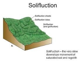
Solifluction is a geomorphic process involving a special type of soil flow that is noticed in

Detailed Solution for UGC NET Paper 2 Geography Mock Test - 8 - Question 22

The correct answer is permafrost regions.

Key Points

  • Solifluction refers to the progressive movement of a mass down a slope ("mass wasting") as a result of the freeze-thaw activity. Hence option 3 is correct.
  • It can also be defined as a type of creep that occurs in cold regions or at high elevations and occurs when the mass of saturated rock waste flows down the slope.
  • The slow downslope movement of the surface rocks is referred to as soil creep.
  • It's both a continuous process and a surface phenomenon that happens on slopes.

Hence option 3 is correct.

UGC NET Paper 2 Geography Mock Test - 8 - Question 23

_______ are lines drawn on a map to locate, in the plan view, points of equal ground elevation.

Detailed Solution for UGC NET Paper 2 Geography Mock Test - 8 - Question 23

The line joining the points of equal elevation on ground called contour line and the difference of elevation between two consecutive contours is called contour intervals.

Important points about Contour Line:

  1. Contour line never cross each other and never joins at one location except Vertical Cliff or overhang.
  2. All contours on earth surface are always closed contours.
  3. Contours of small spacing indicate steep slope and contour of large spacing indicate mild or gentle slope.
  4. If some contours are found in small map or small area then it indicates a pond or hill in that area.
UGC NET Paper 2 Geography Mock Test - 8 - Question 24
What does ENSO stand for?
Detailed Solution for UGC NET Paper 2 Geography Mock Test - 8 - Question 24

ENSO refers to a condition where the rising air in the east Pacific cools above and turns west wards in the troposphere and ultimately descends in the tropical western Pacific giving birth to high pressure which drives war air towards the coasts of South America, Thus, in this manner a complete convective cell is formed and is known as ENSO.

UGC NET Paper 2 Geography Mock Test - 8 - Question 25
Mode>Median>Mean implies what kind of distribution?
Detailed Solution for UGC NET Paper 2 Geography Mock Test - 8 - Question 25

The above condition implies negatively skewed distribution with its tail on the left side of the frequency curve. Skewness refers to the extent of asymmetry in the shape of the frequency distribution curve. Any asymmetry distribution is a skewed distribution. Basically, it measures the extent by which the bulk of the values in a distribution are concentrated on one or the other side of the mean.

UGC NET Paper 2 Geography Mock Test - 8 - Question 26

Palk Strait separates India from

Detailed Solution for UGC NET Paper 2 Geography Mock Test - 8 - Question 26

Palk Strait separates India from Sri Lanka. Palk Strait, inlet of the Bay of Bengal between southeastern India and northern Sri Lanka. It is bounded on the south by Pamban Island (India), Adam’s (Rama’s) Bridge (a chain of shoals), the Gulf of Mannar, and Mannar Island (Sri Lanka).

UGC NET Paper 2 Geography Mock Test - 8 - Question 27
Which of the following is a potential natural resource for India?
Detailed Solution for UGC NET Paper 2 Geography Mock Test - 8 - Question 27

India has the largest reserves of thorium, but it has not yet been utilized. It is said that it can replace Uranium in the nuclear power sector. Thus, it’s a potential natural resource for India that has power to be utilized.

UGC NET Paper 2 Geography Mock Test - 8 - Question 28

The amount of information to be represented on the map depends on

Detailed Solution for UGC NET Paper 2 Geography Mock Test - 8 - Question 28

Other features are shown by a variety of conventional signs, symbols, lines, and patterns, which are printed in appropriate colors and identified by names, labels, and numbers. The chart facing page 22 shows the standard symbols used on the topographic maps of the Survey

UGC NET Paper 2 Geography Mock Test - 8 - Question 29

Periodic change towards unusual colder side is called

Detailed Solution for UGC NET Paper 2 Geography Mock Test - 8 - Question 29

La Niña is a climate pattern that describes the cooling of surface ocean waters along the tropical west coast of South America. La Nina is considered to be the counterpart to El Nino, which is characterized by unusually warm ocean temperatures in the equatorial region of the Pacific Ocean.

UGC NET Paper 2 Geography Mock Test - 8 - Question 30

…………….. type of rainfall is also called 4’O clock rainfall

Detailed Solution for UGC NET Paper 2 Geography Mock Test - 8 - Question 30

In the equatorial regions convectional rainfall is received almost daily in the afternoons. It generally happens regularly at 4 P.M. throughout the year. For this reason it is also called 4'O clock rainfall.

View more questions
Information about UGC NET Paper 2 Geography Mock Test - 8 Page
In this test you can find the Exam questions for UGC NET Paper 2 Geography Mock Test - 8 solved & explained in the simplest way possible. Besides giving Questions and answers for UGC NET Paper 2 Geography Mock Test - 8, EduRev gives you an ample number of Online tests for practice

Top Courses for UGC NET

Download as PDF

Top Courses for UGC NET