TS TET Exam  >  TS TET Tests  >  TS SET Paper 2 Mock Test - 10 (Geography) - TS TET MCQ

TS SET Paper 2 Mock Test - 10 (Geography) - TS TET MCQ


Test Description

30 Questions MCQ Test - TS SET Paper 2 Mock Test - 10 (Geography)

TS SET Paper 2 Mock Test - 10 (Geography) for TS TET 2024 is part of TS TET preparation. The TS SET Paper 2 Mock Test - 10 (Geography) questions and answers have been prepared according to the TS TET exam syllabus.The TS SET Paper 2 Mock Test - 10 (Geography) MCQs are made for TS TET 2024 Exam. Find important definitions, questions, notes, meanings, examples, exercises, MCQs and online tests for TS SET Paper 2 Mock Test - 10 (Geography) below.
Solutions of TS SET Paper 2 Mock Test - 10 (Geography) questions in English are available as part of our course for TS TET & TS SET Paper 2 Mock Test - 10 (Geography) solutions in Hindi for TS TET course. Download more important topics, notes, lectures and mock test series for TS TET Exam by signing up for free. Attempt TS SET Paper 2 Mock Test - 10 (Geography) | 100 questions in 120 minutes | Mock test for TS TET preparation | Free important questions MCQ to study for TS TET Exam | Download free PDF with solutions
TS SET Paper 2 Mock Test - 10 (Geography) - Question 1

Which one of the following is a major plate?

Detailed Solution for TS SET Paper 2 Mock Test - 10 (Geography) - Question 1

The correct answer is option 4.

Key Points

Tectonic Plates:

  • A tectonic plate (also called a lithospheric plate) is a massive, irregularly-shaped slab of solid rock, generally composed of both continental and oceanic lithosphere.
  • A tectonic plate may be a continental plate or an oceanic plate, depending on which of the two occupies the larger portion of the plate.

The Major and Minor Plates: The Earth’s lithosphere is divided into seven major and some minor plates.

  • Young Fold Mountain ridges, oceanic trenches, and/or transform faults surround the major plates. These include:
    • The Antarctic (and the surrounding oceanic) plate. Hence, option 4 is correct.
    • The North American plate (with the western Atlantic floor separated from the South American plate along the Caribbean islands)
    • The South American plate (with the western Atlantic floor separated from the North American plate along the Caribbean islands)
    • The Pacific plate
    • The India-Australia-New Zealand plate
    • Africa with the eastern Atlantic floor plate
    • Eurasia and the adjacent oceanic plate
  • Some important minor plates include:
    • Cocos plate: Between Central America and the Pacific plate
    • Nazca plate: Between South America and the Pacific plate
    • Arabian plate: Mostly the Saudi Arabian landmass
    • Philippine plate: Between the Asiatic and Pacific plate
    • Caroline plate: Between the Philippine and Indian plates (North of New Guinea)
    • Fuji plate: North-east of Australia
    • Juan De Fuca plate: South-East of North American Plate. Hence, options 1, 2 and 3 are not correct.


TS SET Paper 2 Mock Test - 10 (Geography) - Question 2

Which of the following is the cause of tides?

A. Moon's gravitational pull

B. Sun's gravitational pull

C. Centrifugal force

D. Gravitational pull of Earth

Select the answer from the codes given below :

Detailed Solution for TS SET Paper 2 Mock Test - 10 (Geography) - Question 2

The correct answer is A, B and C.

Key Points

  • Tides are the periodic rise and fall of the sea level, once or twice a day.
  • Tides are caused by the earth-moon-sun positions.
  • They are caused by the gravitational forces exerted on the earth by the moon, and to a lesser extent, the sun.
  • Causes of tides are:
    • Sun's gravitational pull
    • Moon's gravitational pull
    • Centrifugal force
  • Centrifugal force is the force that acts to counter balance the gravity.
  • Tides vary in their frequency, direction and movement from place to place and also from time to time.

Thus, we can say that the moon's gravitational pull, the sun's gravitational pull and the centrifugal force are causes of tides.

1 Crore+ students have signed up on EduRev. Have you? Download the App
TS SET Paper 2 Mock Test - 10 (Geography) - Question 3

The organisations lay stress on liberalisation of foreign trade and foreign investment is

Detailed Solution for TS SET Paper 2 Mock Test - 10 (Geography) - Question 3

The organization that lays stress on the liberalization of foreign trade and foreign investment is World Trade Organisation.

Important PointsWorld Trade Organisation:

  • The World Trade Organization came into being in 1995.
  • One of the youngest of the international organizations, the WTO is the successor to the General Agreement on Tariffs and Trade (GATT) established in the wake of the Second World War.
  • So while the WTO is relatively young, the multilateral trading system that was originally set up under the GATT is over 70 years old.
  • World Trade Organisation (WTO) is one such organization whose aim is to liberalize international trade.
  • Starting at the initiative of the developed countries, WTO establishes rules regarding international trade and sees that these rules are obeyed.
  • At present 164 countries of the world are currently members of the WTO since 29 July 2016.
  • Though WTO is supposed to allow free trade for all, in practice, it is seen that the developed countries have unfairly retained trade barriers.

Additional Information

  • United Nations: The United Nations is an intergovernmental organization aiming to maintain international peace and security, develop friendly relations among nations, achieve international cooperation, and be a center for harmonizing the actions of nations.
  • World Health Organisation: The World Health Organization is a specialized agency of the United Nations responsible for international public health.
  • Food and Agricultural Organization: The Food and Agriculture Organization of the United Nations is a specialized agency of the United Nations that leads international efforts to defeat hunger and improve nutrition and food security.
TS SET Paper 2 Mock Test - 10 (Geography) - Question 4

In which layer the maximum part of the atmosphere (by mass) is found?

Detailed Solution for TS SET Paper 2 Mock Test - 10 (Geography) - Question 4

The Correct Answer is Troposphere.

Key Points

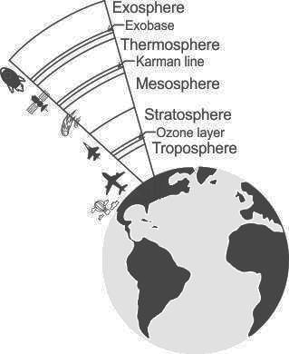
  • Troposphere
    • The troposphere is the lowest portion of Earth’s atmosphere and contains approximately 80% of the atmosphere’s mass and 99% of its water vapor and aerosols.
    • The average depth of the troposphere is approximately 17 km in the middle latitudes.
    • The characteristic features of the Troposphere are its great density.
    • In addition to nitrogen and oxygen, carbon dioxide, and water vapor (nearly all of the water vapor contained in the atmosphere is concentrated in the troposphere) and numerous particles of various origin
    • It thickness of the Troposphere is maximum at the equator, deeper in the tropics, up to 20 km, and shallower near the polar regions, at 7 km in summer, and indistinct in winter.
    • In India, it is taken to be around 16 Kilometers.
    • The thickness of the troposphere and consequently the atmosphere is maximum at the equator.
    • Almost all clouds are found in the troposphere.

Additional Information

  • Stratosphere
    • It is the second layer of the atmosphere found above the troposphere.
    • It extends up to 50 km in height.
    • This layer is very dry as it contains little water vapour.
    • This layer provides some advantages for flight because it is above stormy weather and has steady, strong, horizontal winds.
    • The ozone layer is found in this layer.
    • The ozone layer absorbs UV rays and safeguards the earth from harmful radiation.
    • Stratopause separates Stratosphere and Mesosphere.
  • Mesosphere
    • It is the coldest of the atmospheric layers.
    • The mesosphere starts at 50 km above the surface of Earth and goes up to 85 km.
    • The temperature drops with altitude in this layer.
    • By 80 km it reaches -100 degrees Celsius.
    • Meteors burn up in this layer.
    • Mesopause separates Mesosphere and Thermosphere.
  • Thermosphere
    • This layer is found above Mesopause from 80 to 400 km.
    • Radio waves that are transmitted from the earth are reflected by this layer.
    • The temperature increases with height.
    • Satellites occur in this layer.
  • Exosphere
    • It is the outermost layer of the atmosphere.
    • The zone where molecules and atoms escape into space is mentioned as the exosphere.
    • It extends from the top of the thermosphere up to 10,000 km.

TS SET Paper 2 Mock Test - 10 (Geography) - Question 5
The concept of ‘Ecological niche’ was introduced by _______.
Detailed Solution for TS SET Paper 2 Mock Test - 10 (Geography) - Question 5

Correct Answer: J. Grinnell.

Key Points

  • The ecological niche of a species has been defined by the resources it requires and by its role or function in the environment. The concept of the ecological niche when introduced by Grinnell (1917) focused on the habitat requirements of a species for it to survive and reproduce.
  • The concept of the ecological niche was first introduced by Joseph Grinnell in 1917. focused on the environmental factors that determined where a species could survive rather than interactions between species. Around the same time, an English ecologist named Charles Elton was developing his own ideas about niches. In his definition, a species’ niche was determined by its interactions with other species—namely its relationships with food and predators
  • A plant's or animal's niche, or more correctly, ecological niche, is a way of life that is unique to that species. Niche and habitat are not the same. While many species may share a habit, this is not true for a niche. Each plant and animal species is a member of a community. The niche describes the species' role or function within this community.
  • Almost 40 years later, in the late 1950s, English ecologist G. Evelyn Hutchinson blended these two versions into a broader definition. This definition considers all abiotic and biotic factors that influence a species in a quantifiable way. This definition is still used by scientists today. It is important to keep learning about species’ niches today because it can help us understand how organisms will respond to environmental changes caused by humans.

Additional Information

  • In ecology, a niche is a term with a variety of meanings related to the behavior of a species living under specific environmental conditions. The ecological niche describes how an organism or population responds to the distribution of resources and competitors. The ecological niche concept expresses the relationship of an individual or a population to all aspects of its environment. Studies on the relationship between the human population and environmental resources have employed a niche concept. The ecological niche comprehends all conditions necessary for an organism to exist.
  • In ecology, the term “niche” describes the role an organism plays in a community. A species’ niche encompasses both the physical and environmental conditions it requires (like temperature or terrain) and the interactions it has with other species (like predation or competition).
  • For example, the rare Kirtland’s warbler (Setophaga kirtlandii), a small songbird of North America, has a very limited niche. It nests only among young jack pine trees (Pinus banksiana), which require periodic wildfires for their seeds to germinate. In this environment, one of the species interactions it must contend with is nest parasitism by the brown-headed cowbird (Molothrus ater). Cowbirds lay their eggs in nests built by other bird species and these host birds then incubate and raise the cowbird’s young, often at the expense of their own babies.
TS SET Paper 2 Mock Test - 10 (Geography) - Question 6
The Chaudhary Charan Singh Airport is located in
Detailed Solution for TS SET Paper 2 Mock Test - 10 (Geography) - Question 6

Chaudhary Charan Singh International Airport is located in Uttar Pradesh and serves Lucknow. It was earlier known as Amausi airport.

TS SET Paper 2 Mock Test - 10 (Geography) - Question 7

The …………….. clouds are vertical clouds

Detailed Solution for TS SET Paper 2 Mock Test - 10 (Geography) - Question 7

Although it is usually a low-based cloud, it actually forms most commonly in the middle level of the troposphere and then spreads vertically into the low and high levels. Nimbostratus usually produces precipitation over a wide area. Nimbo- is from the Latin word nimbus, which denotes precipitation.

TS SET Paper 2 Mock Test - 10 (Geography) - Question 8

Given below are two statements. One is labelled as Assertion (A) and the other is labelled as Reason (R).

Assertion(A) : Unsupervised Classification normally requires only a minimal amount of input from the analyst.

Reason(R) : A priori knowledge of the scene or training sites are required to run this classification.
Select the correct answer from options given below :

Detailed Solution for TS SET Paper 2 Mock Test - 10 (Geography) - Question 8

Unsupervised classification is a process whereby numerical operations are performed by the computer system itself that search for the natural groupings of the spectral properties of pixels in the multi spectral feature space. This method doesn't require much initial output and a priori knowledge of the scene as clustering does not involve training data.

Thus, the Correct answer is C.

TS SET Paper 2 Mock Test - 10 (Geography) - Question 9

What is the correct sequence of occurrence of various atmospheric layers from earth's surface?

1. Exosphere

2. Stratosphere

3. Troposphere

Choose the correct answer from the options given below

Detailed Solution for TS SET Paper 2 Mock Test - 10 (Geography) - Question 9

The correct answer is 321.

Key Points

  • It envelops our world, keeps us warm, provides us with oxygen to breathe, and is the source of our weather.
  • The six layers that make up the Earth's atmosphere are troposphere, stratosphere, mesosphere, thermosphere, ionosphere, and exosphere.
  • The troposphere is our atmosphere's lowest layer. It rises from the ground to a height of around 10 kilometres above sea level.
  • The stratosphere is situated 50 kilometres above sea level.
  • The mesosphere is located above the stratosphere. It reaches a height of around 85 kilometres (53 miles) above our planet.
  • The exosphere is the outermost layer of the atmosphere.

Therefore, Troposphere⇒Stratosphere⇒Mesosphere

Additional Information

  • The ionosphere is not a discrete layer.
  • The ionosphere is a succession of zones in the mesosphere and thermosphere where high-energy solar radiation has thrown electrons lose from their parent atoms and molecules.
TS SET Paper 2 Mock Test - 10 (Geography) - Question 10
Given below are two statements- one is labelled as Assertion (A) and the other is labelled as Reason (R):

Assertion (A)- Spykman argued that the Heartland theory appeared less important than the Rimland.

Reason (R)- Mackinder presented his model at the end of the railway age and did not mention about the superiority of air navigation as well as the railways.

Choose the correct option:

Detailed Solution for TS SET Paper 2 Mock Test - 10 (Geography) - Question 10

One of the serious faults of Mackinder's Heartland theory is that, though he had presented his model during the railway age, he never mentioned the presence of this huge transport facility. During that time railways had almost dominated quite several years. He also did not make any attempt to elaborate the impacts of air mobility on his newer versions of the model. However, during his model the role of technology had a major impact on the power potentials. Mackinder failed to recognize the effect of the role of changing technology. The Rimland theory by Spykman tends to cover up these weaknesses that were present in the Heartland theory.

TS SET Paper 2 Mock Test - 10 (Geography) - Question 11

Given below are two statements. One is labelled as Assertion (A) and the other is labelled as Reason (R).

Assertion (A): There is high density of population in Chotanagpur plateau.

Reason (R) : Various minerals are found in the Chotanagpur plateau.

Select the correct answer from options given below:

Detailed Solution for TS SET Paper 2 Mock Test - 10 (Geography) - Question 11

 The Chotanagpur plateau of Jharkhand has abundance of minerals such as iron, coal, copper, bauxite, etc. The area thus provides employment opportunities in mining and other heavy industries. This has led to high density of population in the Chotanagpur plateau. Thus, both (A) and (R) are true and (R) is the correct explanation of (A).

TS SET Paper 2 Mock Test - 10 (Geography) - Question 12

Through which state do the rivers Chenab, Ravi, Beas, Sutlej and Yamuna flow?

Detailed Solution for TS SET Paper 2 Mock Test - 10 (Geography) - Question 12

The correct answer is Himachal Pradesh.

 Key Points

  • Rivers in Himachal Pradesh:
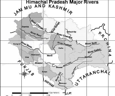
    • The perennial rivers found in the Indian state of Himachal Pradesh are Beas, Chenab, Ravi, Satluj, and Yamuna.
    • Beas river arises from the Pir Panjal range near the Rohtang pass.
      • It covers a distance of approx. 256 km in the state.
      • The tributaries of the river Beas are Parbati, Hurla, Sainj, Uhl, Suheti, Luni, Banganga, and Chaki.
    • Chenab is the largest river formed by the two streams named Chandra and Bhaga.
      • These two meet at Tandi in Lahaul (Lahaul and Spiti district).
      • It flows for a distance of approx. 122 km in the state.
    • Ravi river rises from Bara Banghal of Kangara district, Himachal Pradesh.
      • The river covers a distance of approx. 158 km.
    • Satluj river originates from Tibet, crosses the Indo-Tibetan border, and joined by the Spiti river.
      • The river emerges from the mountains at the Bhakra and has a catchment area of about 20,000 sq km. in Himachal Pradesh.
    • Yamuna river originates from Yamunotri in the Uttarkashi district of Uttarakhand.
      • The tributaries of the river are Tons, Giri, and Bata, and the catchment area of about 2,320 sq km.

Additional Information 

  • ​Beas river has a total length of 470 km and is home to the Indus dolphin.
    • The river passes through Himachal Pradesh, Punjab, and Pakistan. As per the Indus Water Treaty, the water of the river Beas is allocated to India.
  • The river Chenab flows through Himachal Pradesh, Punjab, Jammu and Kashmir, and Pakistan. 
    • As per the Indus Water Treaty, the water of the river Chenab is allocated to Pakistan.
    • The major dams found on the river are the Salal Dam, Pakal Dul Dam, etc.
  • The river Ravi flows through the Indian states of Punjab, Himachal Pradesh, Jammu and Kashmir, and Rajasthan.
    • It also flows through Pakistan. As per the Indus Water Treaty, the water of the river Ravi is allocated to India.
    • The Ranjit Sagar Dam is built on the Ravi river.
  • The river Satluj is the longest of the five river systems of Punjab.
    • The river passes through three countries viz China, India, and Pakistan. 
    • As per the Indus Water Treaty, the water of the river Satluj is allocated to both India and Pakistan.
    • Bhakra Nangal Dam, Karcham Wangtoo Hydroelectric Plant, Nathpa Jhakri Dam are built on the river Satluj.
  • The Yamuna river the longest and the second-largest tributary of the river Ganga.
    • The river has a total length of approx. 1,376 km.
    • The river flows through states like Uttarakhand, Himachal Pradesh, Haryana, Delhi, and Uttar Pradesh.
    • Important tributaries of the river are Tons, Hindon, Ken, Chambal, Sindh, Sasur Khaderi, and Betwa.​​

TS SET Paper 2 Mock Test - 10 (Geography) - Question 13
Which of the following statements are true about John Friedmann’s Matter of the Centre Vs. Periphery?

(a) The theory is similar to Growth Pole Theory by Francis Perroux.

(b) Development poles are urban centers with many economic activities which are diversified in nature.

(c) The central town is the supplier of commodities for consumption.

(d) The central district provides raw material to the peripheral towns.

Select the correct answer from the codes given below:

Detailed Solution for TS SET Paper 2 Mock Test - 10 (Geography) - Question 13

John Friedmann presented his theory in 1966 about the difference central town and periphery. The theory makes two parts of developing town, as given by Francis Perroux. The theory divides a developing towns/poles into f types: Central cities, growth poles, development poles and integration poles. The development poles are urban districts which have diversified economic activities. The central town or pole is centre of development. The finished product is available here for input into tertiary activities and for consumption. It takes the required raw materials from towns in periphery.

Thus, the correct answer is A.

TS SET Paper 2 Mock Test - 10 (Geography) - Question 14
Which of the following is not an example of spatial data?
Detailed Solution for TS SET Paper 2 Mock Test - 10 (Geography) - Question 14

The correct answer is option 3.

Concept:

Spatial data:

Spatial data is any kind of data that refers to a certain geographical region or place, either directly or indirectly. Spatial data, also known as geospatial data or geographic information, can quantitatively represent a physical item in a geographic coordinate system.

Example of spatial data:

A common example of spatial data can be seen in a road map.

A road map is a two-dimensional object that contains points, lines, and polygons that can represent cities, roads, and political boundaries such as states or provinces. A road map is a visualization of geographic information.

The location of cities, roads, and political boundaries that exist on the surface of the Earth is projected onto a two-dimensional display or piece of paper, preserving the relative positions and relative distances of the rendered objects.

Hence the correct answer is times of particular events.

TS SET Paper 2 Mock Test - 10 (Geography) - Question 15
Consider the following statements on application areas of remote sensing and choose which amongst them is true:

i. Remote sensing is used in crop acreages estimation

ii. Different methods of remote sensing are used in soil categorization.

iii. Remote sensing is used in lithological discrimination

iv. Various methods of remote sensing are also used in major river valley projects. .

Detailed Solution for TS SET Paper 2 Mock Test - 10 (Geography) - Question 15

Remote sensing is used to acquire the data of remotely sensed areas. It is used in the fields like crop acreages estimation, lithological discrimination, coral reef mapping, forest cover mapping, loss of biological diversity, wealth of oceans, oil fields detection, major river valley projects, management of wild rivers, environment impact analysis amongst many others.

Thus, the Correct answer is D.

TS SET Paper 2 Mock Test - 10 (Geography) - Question 16

Given below are two statements, one labelled as assertion(A) and other labelled as reason(R).

Assertion(A)- Aerial photographs are more useful when spatial detail is more critical than spectral information.

Reason(R)- Aerial photograph’s spectral resolution is generally coarse.

Detailed Solution for TS SET Paper 2 Mock Test - 10 (Geography) - Question 16

Aerial photographs are most useful when fine spatial detail s more critical than spectral information, as their spectral resolution is generally coarse when compared to data captured with electronic sensing devices. The geometry of vertical devices is well understood and it is possible to make very accurate measurements from them.

TS SET Paper 2 Mock Test - 10 (Geography) - Question 17

The word ‘Map’ derived from Mappa of

Detailed Solution for TS SET Paper 2 Mock Test - 10 (Geography) - Question 17

The word "map" comes from the medieval Latin Mappa mundi, wherein mappa meant napkin or cloth and mundi the world. Thus, "map" became the shortened term referring to a two-dimensional representation of the surface of the world.

TS SET Paper 2 Mock Test - 10 (Geography) - Question 18
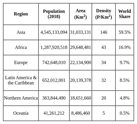
Which of the following Regions has the highest population density?
Detailed Solution for TS SET Paper 2 Mock Test - 10 (Geography) - Question 18
TS SET Paper 2 Mock Test - 10 (Geography) - Question 19
Which of the following methods may be used to input paper maps into a GIS?
Detailed Solution for TS SET Paper 2 Mock Test - 10 (Geography) - Question 19

The correct option is (3)

Concept:-

Scanning, Manual digitizing and Automatic digitizing are the methods may be used to input paper maps into a GIS.

Key Points

  • Paper maps are static depictions of land features as they existed at the time they were made.
  • A digitising tablet, which is a manual pointing device that creates an equivalent vector map on the computer screen, specifying the vertices, points, line data, and so on, is used to manually digitise directly over the raster.
  • GIS was created as an enhancement to the usage and analysis of traditional paper maps.
  • A geographic information system (GIS) is a computer programme that captures, stores, checks, and displays data about locations on the Earth's surface.
  • In a GIS, digitising is the process of converting coordinates from a map, photograph, or other source of data into a digital format.
  • Scanning is the process of converting paper maps into a digital format that can be read by a computer. It's used to turn an analogue map into a scanned file, which is then traced into vector format.
TS SET Paper 2 Mock Test - 10 (Geography) - Question 20
The last decade of 19th century and early 20th century were focused on
Detailed Solution for TS SET Paper 2 Mock Test - 10 (Geography) - Question 20

In the last decade of 19th century and early years of 20th century, social Darwinist thought was prevalent. It was reflected in Ratzel ad his contemporaries’ thought. Geography rejected physical geography and environmentalism and focused mostly on environmental determinism that was Darwin’s thoughts.

TS SET Paper 2 Mock Test - 10 (Geography) - Question 21
In case of a remote sensing system, which of the following factors does NOT affect the property of a reflected incident radiation?
Detailed Solution for TS SET Paper 2 Mock Test - 10 (Geography) - Question 21

Explanation

When the energy from an external source enters Earth's atmosphere, it interacts with the atmosphere and gets

Refracted-> Scattered -> Absorbed .

The radiant energy from the Sun, after passing through the atmosphere reaches the Earth's surface, and three things happen

i) some portion of the energy is reflected by the
earth surface,

ii) some portion of energy is transmitted into the surface

iii) and some portion of it is absorbed and emitted by the earth’s surface later on

Talking specifically about the reflectance property of the earth's surface which affects the reflected rays

  • The reflection intensity depends on the surface roughness, absorption coefficient, and the angles of incidence and reflection.
  • Surface roughness is a function of the wavelength of incident radiation
  • Depending upon whether the surface is smooth or rough, the reflection can be either specular or diffuse.

we can answer the question with this knowledge

TS SET Paper 2 Mock Test - 10 (Geography) - Question 22
The heights of any place on the land are measured from,
Detailed Solution for TS SET Paper 2 Mock Test - 10 (Geography) - Question 22

The correct answer is mean sea level.

Key Points

  • The heights of any place on the land are measured from mean sea level.
  • This is because sea is a continuous water body and its surface tends to seek the same level throughout the world.
  • Mean sea level is an average surface level of one or more among Earth's coastal bodies of water from which heights such as elevation may be measured.
  • A common mean sea level standard is the midpoint between a mean low and mean high tide at a particular location.

 Thus, we can say that the heights of any place on the land are measured from the mean sea level.

Additional Information

  • A plain is a broad area of relatively flat land.
  • A slope is the rise or fall of the land surface.
TS SET Paper 2 Mock Test - 10 (Geography) - Question 23
Trough and ridge are
Detailed Solution for TS SET Paper 2 Mock Test - 10 (Geography) - Question 23

The correct answer is option 1.

  • A trough is an elongated area of relatively low pressure extending from the centre of a region of low pressure.
  • A ridge is an elongated area of relatively high pressure extending from the centre of a high-pressure region.

Key Points

  • Troughs and ridges are pressure field qualities that can be noticed on a weather map.
  • Troughs are found in low-pressure locations, whereas ridges are found in high-pressure areas.
  • Troughs are elongated areas of low pressure that generally occur before a cold front. A trough is sometimes a sign of impending clouds, precipitation, or a change in wind direction.
  • Ridges are extended areas of relatively high pressure in the weather. As a result, the area around them becomes dry. They can also bring onshore breezes, which can cause coastal rains.
  • Troughs are notorious for providing cool, cloudy weather, whereas ridges typically offer warmer, drier weather. This phenomenon occurs when the air in a high-pressure area or ridge compresses and warms as it falls. When this happens, cloud production is slowed, therefore sunny skies are more frequent in high-pressure areas. When it comes to low-pressure areas, the opposite is true.

TS SET Paper 2 Mock Test - 10 (Geography) - Question 24
Which fault line is the most active fault line in Himalaya system?
Detailed Solution for TS SET Paper 2 Mock Test - 10 (Geography) - Question 24

 The Main Central Thrust (MCT) lies between Greater Himalayas and Lesser Himalayas. Many earthquakes have occurred along this fault line. Some of these include earthquakes at Srinagar in 2005, Kandla in 1905, Uttarkashi in 1993 and Kathmandu in 2015. It is the most active fault line in Himalayan mountain system.

Thus, the correct answer is A.

TS SET Paper 2 Mock Test - 10 (Geography) - Question 25

Match the List - I with List - II and select the correct answer from the code given below :

Detailed Solution for TS SET Paper 2 Mock Test - 10 (Geography) - Question 25
  • Cleveland lies in the North American Industrial region. It has many steel and manufacturing industries. The other centers in this region include Detroit, Boston, Baltimore, etc.
  • Kazan has petrochemical, mechanical engineering, chemical, light and food industries. It belongs to Central European and Russian industrial region.
  • Busan is a logistic hub and financial centre in South Korea. It belongs to Central Asian industrial region.
  • Frankfurt is in Germany and belongs to western European industrial region. Essen, Dusseldorf, etc. are other centers in German province. A variety of financial industries are present in Frankfurt.
TS SET Paper 2 Mock Test - 10 (Geography) - Question 26
A passive sensor uses:
Detailed Solution for TS SET Paper 2 Mock Test - 10 (Geography) - Question 26

Explanation:

There are two types of sensors in remote sensing:

1) Passive remote sensing (Sensor):

  • It depends on a natural source to provide energy for data collection. Sun is the most commonly used source of energy for passive remote sensing.
  • However, passive remote sensing can be done in absence of the Sun. In this case, the target material itself is the source of energy, and the sensor records primarily emitted radiation.
  • Examples: Return bram vidicon, Electro-optical scanner, and Electro-optical radiometer use light as the primary source.

2) Active remote sensing (Sensor):

  • It uses a man-made source of energy. In this case, humans can manipulate the nature of source energy (wavelength, power, duration).
  • Examples: Radar
TS SET Paper 2 Mock Test - 10 (Geography) - Question 27

Which of the following states is sole producer of agate, chalk, and perlite in India?

Detailed Solution for TS SET Paper 2 Mock Test - 10 (Geography) - Question 27

Gujarat is the sole producer of agate, chalk, and perlite and is leading producer of fluorite (concentrate), fireclay, silica sand, lignite, laterite, petroleum and natural gas and bauxite in the country. State is the sole holder of country’s resources of perlite, 66% of fluorite, 28% of diatomite, 18% of bentonite and 12% of wollastonite. [Ministry of Mines]

So, the correct option is C.

TS SET Paper 2 Mock Test - 10 (Geography) - Question 28
Given below are two statements. One is labelled as Assertion (A) and the other is labelled as Reason (R).

Assertion(A)- According to Anthony Giddens human agency and social structure are not two separate concepts.

Reason(R)- Structure is a continuous process which is carried out in a flow.

Select the correct answer from options given below:

Detailed Solution for TS SET Paper 2 Mock Test - 10 (Geography) - Question 28

Structuration theory was majorly propounded by Giddens and Bourdieu. According to Giddens human agency and social structure are not two separate concepts or constructs, but these are together produced by social action and interaction. He states it as an outcome of a continuous process or flow of process.

Thus, the Correct answer is A.

TS SET Paper 2 Mock Test - 10 (Geography) - Question 29

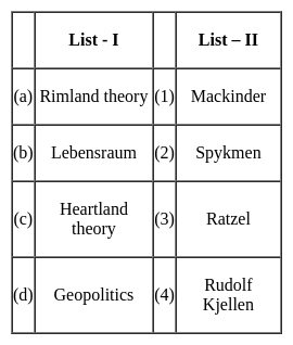
Match the concepts (List - I) with their proponents (List - II) selecting correct answer from the codes given below :
Detailed Solution for TS SET Paper 2 Mock Test - 10 (Geography) - Question 29

The correct answer is (a) - (2), (b) - (3), (c) - (1), (d) - (4)

Key Points

  • Heartland theory was given by British political geographer H J Mackinder in the year 1904. "The Geographical Pivot of History" is an article submitted by Halford John Mackinder in 1904 to the Royal Geographical Society that advances his heartland theory. In this article, Mackinder extended the scope of geopolitical analysis to encompass the entire globe.
  • Heartland theory believed that whoever controls the heartland( Siberia and part of central Asia) will control the world islands whereas rimland theory believed that whoever controls the rimland (Inner marginal crescent) comprised Europe, North Africa, West Asia, India, South East Asia, and part of China will control the world islands
  • Spykeman propounded the Rimland theory in opposition to the Heartland theory of Mackinder. Spykman proposed a theory that countered Mackinder's Heartland Theory. According to his rimland theory, the coastal areas or littorals of Eurasia are key to controlling the World Island, not the Heartland. As per Spykman, landlocked states usually faced security challenges from their immediate neighbors.
  • The ideology of Nazism Party workers and also Adolf Hitler was Lebensraum which meant that the living space or territory area extended to enable the material resources and the power of the German Nation and also established the new territory for their people settlement.
  • The term Lebensraum was coined by the German geographer, Friedrich Ratzel (1844-1904). During the last two decades of the 19th century, Ratzel developed a theory according to which the development of all species, including humans, is primarily determined by their adaptation to geographic circumstances.
  • Geopolitics, analysis of the geographic influences on power relationships in international relations.
  • The word geopolitics was originally coined by the Swedish political scientist Rudolf Kjellén about the turn of the 20th century, and its use spread throughout Europe in the period between World Wars I and II (1918–39) and came into worldwide use during the latter.
TS SET Paper 2 Mock Test - 10 (Geography) - Question 30

The cadastral maps, topographical maps and the city plans come under the category of

Detailed Solution for TS SET Paper 2 Mock Test - 10 (Geography) - Question 30

Topographic maps are based on topographical surveys. Performed at large scales, these surveys are called topographical in the old sense of topography, showing a variety of elevations and landforms. This is in contrast to older cadastral surveys, which primarily show property and governmental boundaries.

View more questions
Information about TS SET Paper 2 Mock Test - 10 (Geography) Page
In this test you can find the Exam questions for TS SET Paper 2 Mock Test - 10 (Geography) solved & explained in the simplest way possible. Besides giving Questions and answers for TS SET Paper 2 Mock Test - 10 (Geography), EduRev gives you an ample number of Online tests for practice

Top Courses for TS TET

Download as PDF

Top Courses for TS TET